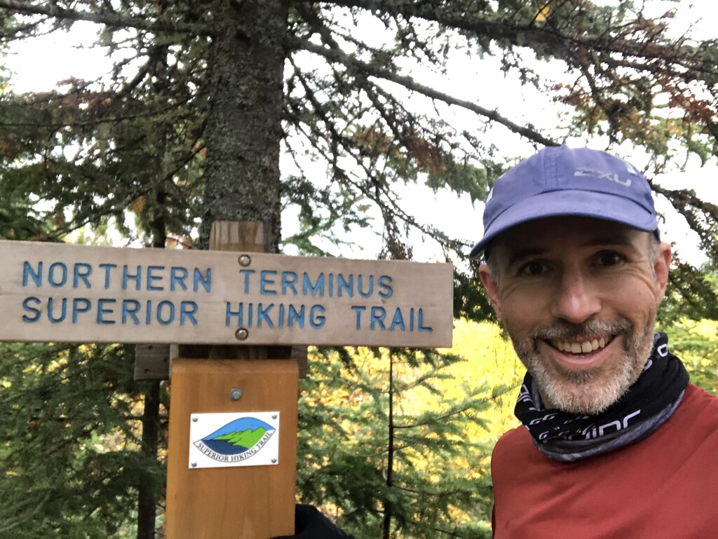

Superior Hiking Trail (SHT)
Unsupported FKT Attempt
Jeff Rauenhorst (user id: jeffrauenhorst)
Start: September 28, 7:55am
Finish: October 4, 1:54am
5 days, 17 hours, 59 minutes
Overall:
- I carried all my own food and everything I needed from start to finish, including garbage.
- I only got water from natural sources.
- I did not receive any external support.
- I did the trail southbound.
Data sources
- Garmin inReach Mini
- I turned off the inReach at night
- Note: some mornings I forgot to turn on the inReach when I left. Luckily I also have the watch/Strava data
- https://share.garmin.com/jeffr
- Garmin Fenix 6X GPS watch – posted to Strava
- https://www.strava.com/activities/4155877646/overview
- https://www.strava.com/activities/4155886694/overview
- https://www.strava.com/activities/4155896749/overview
- https://www.strava.com/activities/4155904867/overview
- https://www.strava.com/activities/4155914354/overview
- https://www.strava.com/activities/4155924076/overview
For FKT Verification: Note two reroutes on the trail. See sections below labeled ***Reroute Notes***
September 28 - Day 1
270 Overlook to West Devils Track
After fumbling around with my technology, I started at 7:56am. Since both Strava and Garmin say 7:55am, that’s easier to verify. Let’s go with a 7:55am start.
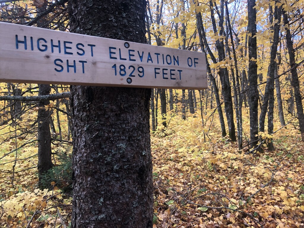
Incredible fall colors. Sensory overload. First day felt easy. Initially flatter than other sections I hiked. Highest and lowest point on the trail today. 1.5 mile walk on the beach (harder than it sounds) during the sunset! Logical place to stop for the night since the next campsite was in 10 miles.
50.2 'official' miles (from the SHT guidebook)
September 29 - Day 2
West Devils Track to Springdale Creek
Got into the heart of the trail where the climbing starts. Through Lusten ski resort. Just truckin. Another logical place to stop (10 miles until next campsite).
47.1 'official' miles (from the SHT guidebook)
September 30 - Day 3
Springdale Creek to West Kennedy Creek
Hardest day. Always going up and down.
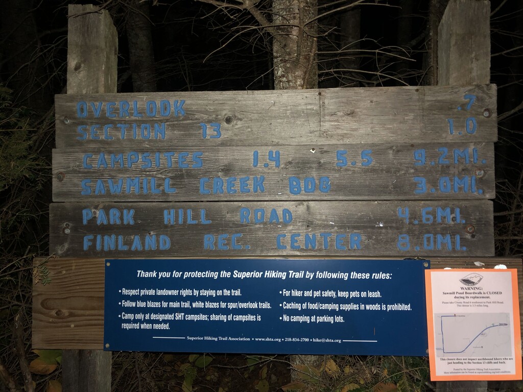
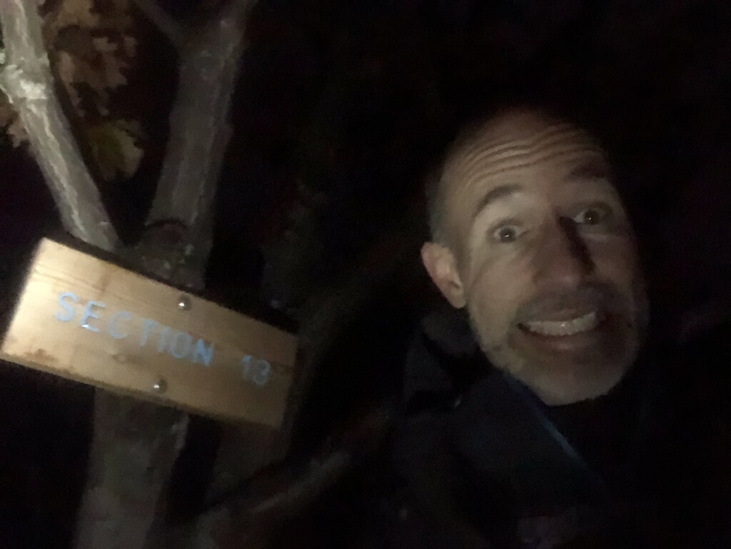
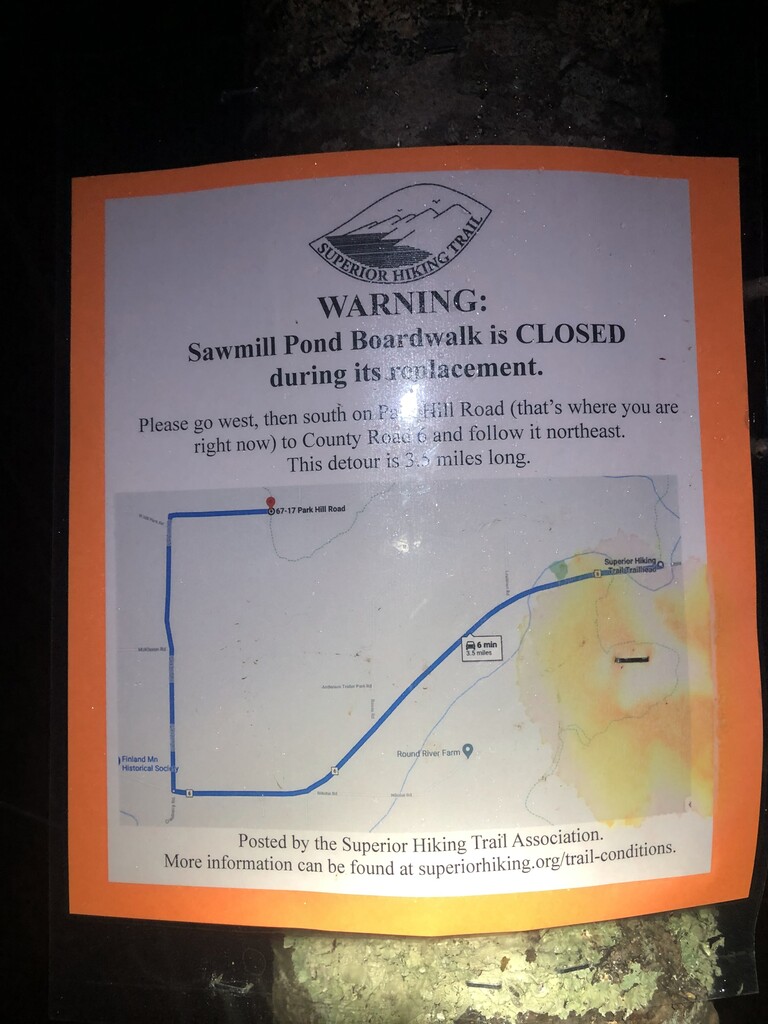
***Reroute Notes***
A section from Park Hill Road to County Road 6 (heading southbound) was closed to a Sawmill Pond Boardwalk being out and getting repaired over a bog.
I walked the reroute. Then I chose to backtrack (head north) and go up Section 13 peak to be 'true to the SHT’. After climbing to the peak, I retraced my route back and then continued on the trail. I did this as the Section 13 peak is one of the ‘iconic’ peaks on the trail and it should get me approximately same elevation gain as normal trail.
The SHT 'Sign' distance to Section 13 is 1.0 miles. I believe this is to the first rock outcropping. I went to the peak. My GPS watch indicated the distance to the Section 13 peak was 1.33 miles. It was the exact same distance down. Round trip 'extra' distance to Section 13 = 2-2.66 miles. Total extra distance traveled = 0.9-1.56 miles.
Park Hill Road to County Road 6
Normal Route
Distance: 4.6 miles
Reroute
Distance: 3.5 miles
1.0 – 1.33 up to Section 13 peak
1.0 – 1.33 back down
Total = 5.5 – 6.16
Extra miles: 0.9 - 1.56 miles
The reroute was required. To be true to the spirit of the trail and to be respectful of the other FKT holders, the extra ~.9 – 1.6 miles outweighs travel on the road.
53.9 'official' miles (from the SHT guidebook)
October 1 - Day 4
West Kennedy Creek to Crow Creek Valley
Got through the hardest, hilliest section of the SHT. Hiking pole broke (fixed with tape). Right knee pain started ~60% of the way through the day. Next campsite was 10 miles.
46.6 'official' miles (from the SHT guidebook)
October 2 - Day 5
Crow Creek Valley to Bald Eagle
Flatter section. Just cruised. Stopped even less. Right shin splints flared up again. Right knee felt better. Left knee started to hurt (overcompensation?). Navigation started to get harder because more trails. At ~12:30am, it took me 15 minutes to figure out how to cross a road intersection. I was disoriented from the dark with the moon behind the clouds ... and I might have been a little tired. Pushed to one of the last campsites before Duluth. Glad I did or else an under 6 day finish would have been very tough.
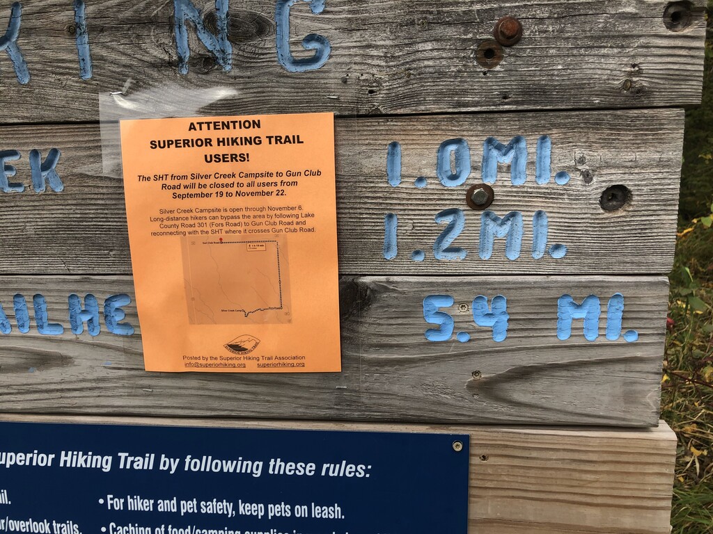
**Reroute Notes**
The section from Silver Creek Campsite to Gun Club Road (24) was closed due to hunting. So at the SHT intersection with Fors Road (301), there is a reroute to head north on Fors Road and west on Gun Club Road.
Note, what I actually did was follow the SHT trail from Fors Road to the Silver Creek Campsite, 1.2 miles down the trail. Then I realized that you could not go any further and backtracked to Fors Road. (I was a little tired, so I thought there was another trail at the campsite that I would have to take. I was mistaken.)
from Silver Creek Campsite to Gun Club Road (24)
Normal Route
Distance: ~4 miles
Reroute
Distance: 3.9 miles
1.2 miles – to Silver Creek Campsite
1.2 miles – from Silver Creek Campsite
Total = 6.3 miles
Extra miles: ~2.3 miles
Thus, I walked ~2.3 extra miles due to this reroute. Whether you call this a mistake or extra miles on trail to compensate for traveling on a road, I think this extra mileage keeps me true to spirit of the trail and to be respectful of the other FKT holders.
56.7 'official' miles (from the SHT guidebook)
October 3 - Day 6
Bald Eagle to Southern Terminus
Through God, all things are possible!
Glad I didn't push farther yesterday because the closer to Duluth, the more trails. Going through the city was a pain as I frequently got lost, backtracked, and found the trail. Before Spirit Mountain was the low point as the trail has some brutal ups and downs. I wasn't yet at the bottom of the ski hill, which was 28 miles to the finish. Got through it and after some flatter stuff (and a podcast), my energy was renewed. There is nothing easy about the last section of this course.
Today was all about pain. Every step had some type of sharp pain from my knees down. I started breathing like my wife did during childbirth! So amazing to have my wife and dad at the finish line! ...and a beer!
55.2 'official' miles (from the SHT guidebook)
NOTE: I have videos of the start and finish that show my watch. I haven't posted them anywhere that is publically available yet, but I can if needed.