Location
Ontario,
CA
Distance
88.4 km
Description
GPS Track
Avon_Ontario_Hatt.gpx19.57 KB
FKTs
Male
Mixed-gender team
| Ryan Flint | 13h 59m 49s | |||
| Jamieson Hatt, Casey Thivierge | 17h 14m 0s |
| Clark Zealand, Ryne Melcher, Monica Scholz | 14h 36m 15s |
Images
Comments
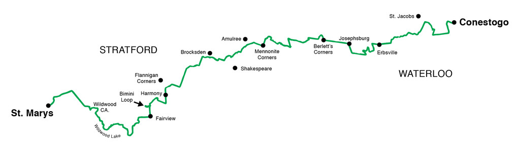
Jamieson Hatt and Casey Thivierge are attempting a self supported fkt of the Avon trail. We will start June 9th(Saturday) at around 4am. We have chosen to start in St Marys and finish in Conestoga. We are stashing some food and water at the halfway point since there isn’t too many opportunities for that near the trail. We may stop at St Jacobs market if need be, but we’ll be close to finishing at that point. We have arranged a ride from Conestoga back to our vehicle in St Mary’s upon completion. I am carrying a Delorme Inreach and I’ll also take date stamped pics. Here’s my live tracking link https://share.garmin.com/JamiesonHatt
Congratulations men! We met you at your water break near Amulree. Best wishes for future endeavours.
Good evening,
As I do not see a women’s FKT, I’d like to take this moment to announce my intention to run this trail end-2-end beginning on June 29th (supported).
Thank you
Chantal Demers
My error - I have since learned that although Monica Scholz covered the distance in a mixed-gender team, she gets the FKT with her time of 14hr36m.
Here is my trip report:
June 29, 2019
5:50AM Start (Sunrise 5:46AM)
Eric D’Arcy and Melanie Boultbee
Start: St - Mary’s
Weather: 26C, feels like 32C. Mostly sunny with some clouds in the morning.
The beginning of the day was fairly uneventful. The run began on a bike path, crossed the main street in St-Mary’s and headed out of town. I had map #1 in my trustee ziplock bag, some fluids and nutrition in my UD pack and I started conservatively, knowing it was going to be a long hot day in the sun. Our plan was simple. I would meet Eric and Melanie every 10ish kilometres at our pre-determined locations. They swapped my water bottle, gave me some food and changed my map, as required. They’d also give me a quick breakdown of what I was to expect in the next section of the trail.
The first 10km were simple, and I rolled through aid station 1 in less than two minutes. The Wildwood Conservation Area was stunning!! Forging ahead, I had a moment of confusion at the 32km map marker on a random loop, but all was well once I figured re-oriented myself. However, the trail conditions got worse pretty much from this moment on. As you could see on the pictures, many sections of the trail were very overgrown. The blazes were often difficult to find and running was slowed to a hike a lot of these sections.
At map marker 45.8, the Avon Trail website stated there was a reroute using a side trail. However, when I arrived at this location, there was a No Trespassing Sign and another sign explaining that this trail was closed. I photographed the signs, informed my crew and then turned around to follow the original trail down the street. Shortly after this, it was PIZZA time! Yummy!!!
Refuelled, and back on the trail, I continued trucking away in the fields and grass of the County. Eric jumped in to run with me at the 72.5km map marker. It was good to share to fields and mosquitoes with him ;) He ran through 2 aid stations with me, skipped one leg and finished the Avon Trail enjoying my singing I’m sure. (total of approx. 37km of pacing duties). We made one navigational error on map #5, but all in all, it was a fun adventure. :) We rolled into the finish at 10:36pm! Kissed the rock and celebrated a 120km (with mandatory reroutes) in 16hrs and 46min. A HUGE thank you to Melanie and Eric for helping me on this rugged trail. Their support was seamless! Big sweaty hug for each of you!!
Verification links
Chantal Demers
On the morning of September 5th, 2020 I will be initiating my self-supported attempt on the Avon Trail. I have arranged for a ride to the western trailhead starting point in St Mary's and will utilize 2 or 3 caches as I move eastward towards the finish in Conestogo. I will have my satellite gps tracker showing my journey in its entirety with live updates throughout the day - link to follow closer to the date.
My progress on this attempt can be tracked at https://share.garmin.com/runraggedrhino