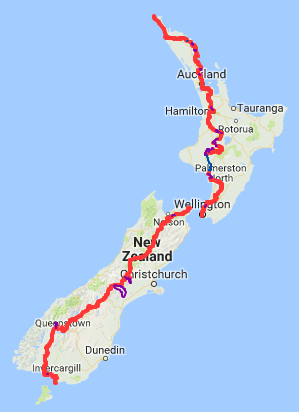
Location
New Zealand
Distance
3,000 km
Description
GPS Track
Te-Araroa.gpx618.26 KB
FKTs
Male
Mixed-gender team
Female
| George Henderson | 49d 14h 27m 0s | |||
| Jez Bragg | Multi-sport | 53d 9h 1m 0s |
| Tim Wright | 69d 20h 37m 0s |
| Tom Bartlett, Madison Wait | 54d 13h 58m 26s |
Images
This route on the old FKT site
Comments
I will be attempting to set a new self-supported FKT in the coming days, starting at Cape Reinga. I will play by the self-supported rules (no outside support, no hitching etc) and will aim for a ~65 day hike. Due to the nature of the trail and official TA guidelines it will however be necessary to use publicly-available transport as follows:
-Ferry from Opua to Okiato, road walk detour due to starting late in the season and no kayak operators willing to rent kayaks to single persons.
-Ngunguru river crossing via James, as per the official TA route and trail notes (tide dependent)
-Marsden Point river taxi via Blair, as per the official TA route and trail notes
-Kayak section starting from Whakahoro rather than Mangapapa due to kayak rental availability as a single persons. This is in line with what the current FKT holder did.
-Water transport from Picton to Ship Cove
-Rakaia braided river bypass, via Shuttle
-Rangitata braided river bypass, via Shuttle
-Lake Wakitapu hazard zone/not officially part of the TA trail, via shuttle or taxi
TBC locations that I’ll send a box to once in Wellington:
St Arnaud
Boyle River
Arthurs Pass
Birchwood
I will track the hike on my public Strava account, using a Coros Apex Pro 2 watch:
https://www.strava.com/athletes/40506007
I take that all back - ha! I already knew this trail absolutely wasn’t for me after day 4. Preserving the body for some other fun adventures. I know there’s a couple others attempting an FKT right now, so best of luck to them!