Hidden Falls Canyon Loop - 3A III - (5 Rappels, Longest Rappel 120 feet.) - is a fun technical canyoneering loop in Red Rocks Natural Conservation Area outside of Las Vegas. It involves some fast moving road miles, steep technical trail, routefinding, and technical canyoneering skills for 5 rappels and downclimbing in a canyon. This FKT is for the TH-TH loop route, no car shuttle or hitchhiking.
TL;DR: This is not a casual trail run. Starting into this canyon without proper skills and gear could lead to being stranded without communication, injury, or death. Know before you go. For a prepared and skilled person this will be a fun obstacle course.
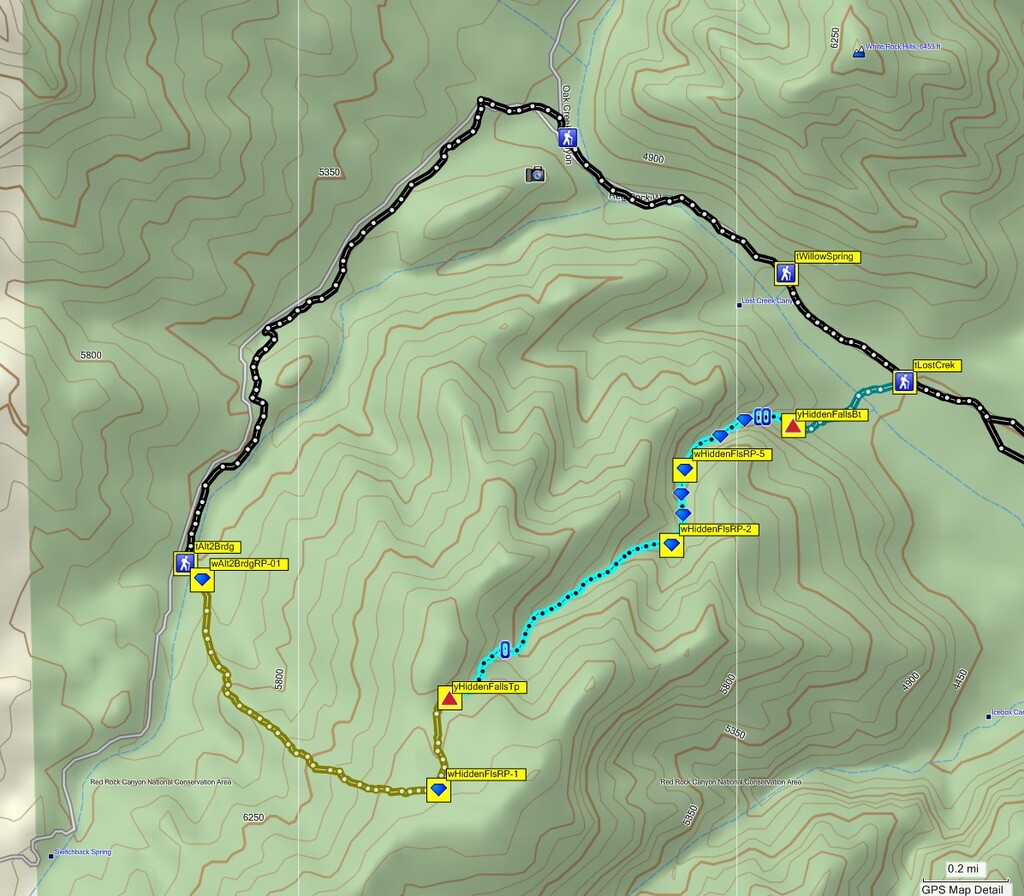
Route Directions (Adapted from Blue Gnome):
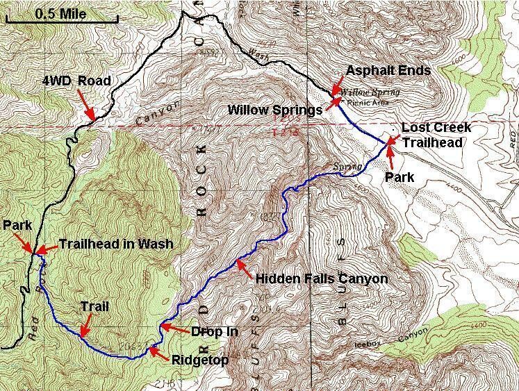
From the Willow Springs parking area / trailhead, run 2.4 miles on Rocky Gap Road to the start of an alternate route to Bridge Mountain. At this point a wash crosses the road coming in from the right (west) side of the road. A few feet before this wash will be a faint use trail leaving the road to the south east. The trail is sometimes marked by a cairn and is where your route leaves the road. The path is hard to see from the road and becomes more apparent a short distance from the road.
The trail leaving the road, leads to a wash running parallel with the road and crosses the wash. Just after crossing the wash the trail becomes wide and starts to follow what looks like the remnants of an old dirt road. You will not follow this wide path very far. Just over 250 feet from leaving Rocky Gap Road, the trail leaves the wide path and turns left to start up the ridge line.
Follow the use trail up the ridge to the west. The use trail has seen a lot more traffic in recent years and has become well worn and easy to follow. The path is easy to follow but is far from being a standard trail. On the way up there is one well traveled path and a few not so well traveled paths and they all tend to go to the same place. Before reaching the top of the ridge, the path is no longer dirt but instead travels up wide open but steep sand stone. Follow the cairns that lead to the top of the ridge.
As you get close to the top of of the climb you will drop slightly as the route up crosses over a wash. This is the top out of the climb if you plan to go directly over to Hidden Falls Canyon. It should take about an hour to travel From Rocky Gap Road to the this wash IF you keep moving. The elevation gain on this section is a little over 1500 feet in about one mile so it is steep. Plan on a slow but continuous pace. The wash you are in now leads directly down into Hidden Falls Canyon to the north. The canyon is easy to spot with a large white wall near its head.
From the wash you have the option to drop your packs and walk over to a great overlook of the area. Walk about 500 further south east to a saddle. From the saddle you will be able to see the top of Ice Box Canyon in front of you to the south east and Bridge Mountain farther in the background. Just below the Bridge Mountain peak is a large natural bridge. It is easy to see but also easy to over look, take a moment to spot it. After you have enjoyed the scenery, walk back down to where you left your packs in the wash.
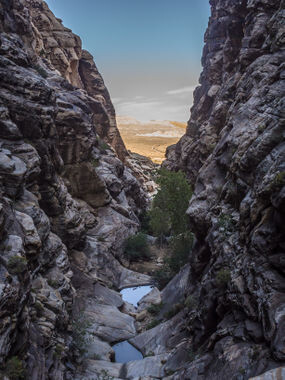
Follow down the wash about 0.2 miles toward Hidden Falls Canyon until the walls of the canyon close in a little and you are in a defined sandstone drainage. The route down the slope starts turning to a rocky wash with desert vegetation. As you get closer to the mouth of the canyon you will start seeing less vegetation and more flat sand stone. The entry for the canyon is where you start finding almost no debris and you begin walking on sandstone as the walls start to rise around you. This is the top entry at the head of Hidden Falls Canyon.
The Canyon / Technical Section:
From the head of the canyon walk a little over 100 feet down canyon to a short down climb followed by Rap 1.
Rap 1: is anchored from a small tree LDC and drops about 25 feet but looks a lot further because the ground below continues to slope downward. Optionally rap 1 can be anchored RDC by threading the webbing through a long tube in the wall about chest high. From the top of Rap 1 you can see Hidden Falls Canyon stretched out in front of you and the Red Rock Scenic Loop in the distance.
Rap 2: is about 0.2 miles down canyon of rap 1 with a few easy down climbs along the way. Rap 2 is anchored from a tree LDC and drops about 120 feet and is the longest rappel on the route. The rap starts out down a steep slope then turns vertical as you work down the rappel. Be sure to look down canyon while on rap 2, the view is great! If you happen to be there when there is still water flowing in the canyon you will be rapping close to a trickling fall to the side of the rappel. After rap 2, put the ropes back in your pack or anywhere that will make them easy to travel with. You will not need ropes for a quite a while.
From the bottom of rap 2 continue down canyon about 0.5 miles where you will find a drop off of about 40 feet that looks like a bad idea to down climb. Along the way is a fair amount of down climbing, nothing too difficult but lots of it. While at the top of the drop, take time to enjoy the rocks LDC of the drop that look like they were stacked into the mountain. By pass the 40 foot drop by climbing up and over RDC to an easier route down a chute. Just below this drop is what looks like another canyon joining in from RDC (south).
Down canyon after the drop is where all the fun begins. The next 0.5 miles is full of down climbs more challenging than what has been done up canyon as well as 3 more rappels. The last bit of the canyon from here may take a few hours to complete depending on the skill level of the team.
From the drop that was bypassed continue down canyon along slick rock about 200 feet along a series of down climbs along ledges. The series of down climbs are spread out along open sections of rock and looks kind of like a skate park would work well for this area except for all the ledges you will be down climbing of course.
About another 200 feet down canyon is a drop of about 50 feet down a series of steep ledges. This drop is a long down climb. It is possible to down climb right down the center on a series of rock ledge that looks a little like a fin of ledged rock working its way down next to the water flow. A better option for some people is to down climb the first 10 feet or so down a crevice to a small ledge to the top of the fin then traverse RDC about 7 feet to a chute to continue the down climb. The chute is still a bit sketchy but offers better foot and hand holds. Up canyon of this drop there is a small shrub and a piton set as an anchor if your party decides it would be a good idea to rap instead.
About 250 feet farther down canyon is a large drop. This is not a rappel and can be climbed around RDC. To get around the drop off, stay high on the right side. Keep working your way around a series of wide open slick rock ledges to find a spot to down climb to the wash below the drop near a large bush / tree.
After several more down climbs over about 300 feet is a drop of about 15 feet under a huge boulder hanging over the drop. A hand line is usually set up there to assist descending the featureless drop. This drop is easily bypassed by climbing up and over the boulder to find a hole that goes under the huge boulder with easy scrambling down to the bottom of the drop.
A little over 500 feet further down canyon is a large drop of about 60 feet. This drop is not a rappel although there is sometimes webbing tied to a small shrub just LDC of the drop so it can be rappelled. Instead down climb a series of ledges LDC to about half way down the drop. Then work over to the center of the watercourse and down climb a shallow crevice that has a lot of features and small ledges to assist in getting to the bottom. At the bottom of the drop is a large pool. If the pool has water the shallowest place to get around is LDC where rocks can be placed as stepping stones.
After more down climbs and about 300 feet farther down canyon is a down climb LDC along the wall that looks difficult from the top. The first 12 feet of the down climb looks difficult but is very easy with lots of ledges large enough to sit on to get a foot down to the next.
About 100 feet further down canyon is another drop of about 30 feet to a pool below if there is water in the canyon. The first 8 or 10 feet of the drop is a little sketchy and all but the last person down should be given a meat anchor. The last person down can hand their pack down and down climb. The start of the down climb is LDC along the wall and is awkward since the angle of the dihedral above leans out making it difficult to lean over to look where your feet are going. A spot from below is a good idea. After getting down the first 8 or 10 feet it is a simple traverse over to a chute to finish down climbing back to the floor. Alternatively you can continue all the way down to the pool and traverse a sloped slick ledge there with the risk of slipping in.
Rap 3: is about another 200 feet down canyon with a short down climb just before reaching the top of the rap. Rap 3 does not drop directly down the water course to the pool below. Instead traverse LDC along a flat ledge up to the anchors. Along the ledge to the anchor is a narrow spot where you will need to be careful as you cross. Rap 3 is anchored from 2 pitons and drops about 60 feet down the side of the canyon to the bottom of the pool below. Optionally rap 3 can be downclimbed scrambled down and is much easier than it looks. A meat anchor can be provided for all but the last person to downclimb if desired. Rap 4 is about 100 feet down canyon.
Rap 3 used to be anchored from a small bush in a crack in the rock LDC of the water course and would drop next to the pool below which then needed to be carefully traversed to get around. In the past bolts had also been added and later removed.
Rap 4: is found by scrambling up and over the ledge on the LDC side over to a chute about 50 feet down canyon to a medium sized tree anchor and drops about 50 feet. There is a crack running over the top lip of the rap that can catch a rope when pulled. The last person down should note this and place the rope well out of the crack. In the past bolts had been added and later removed from rap 4.
Down canyon of rap 4 is a series of small pot holes to walk around LDC before dropping to the gravel wash and a short walk to rap 5.
Rap 5: can be anchored from one of many large boulders in the wash and drops about 70 feet. Extending the webbing over to teh lip will help with a smooth rope pull. In the past bolts had been added and later removed from rap 5.
At the bottom of rap 5 is marked the bottom of the technical section. This is where you may encounter a few hikers since this is end point for the Lost Creek Children's Discovery Trail.
The Exit:
From the bottom of rap 5, follow the Lost Creek children’s discovery trail about 0.3 miles to the trailhead on the road. Once at the road turn left (northwest) and run about 0.4 miles to the Willow Springs trailhead to complete your route.
Resources:
Submitted by Jason Hardrath (IG)
FKTs