From http://greatlaketolaketrails.org/:
The Great Lake-to-Lake Trail offers Michigan’s trail users a unique opportunity to experience quiet rural pathways and urban excursions as it winds its way across the southern lower portion of Michigan from shore to shore. Whether a day listening to the birds chirping is on the docket or grabbing a burger and a quick ride is on the agenda, the trail offers something for everyone. Use our interactive maps to explore the trail or search by region to discover what trek awaits us as we embark on a journey following Michigan’s destination trail.
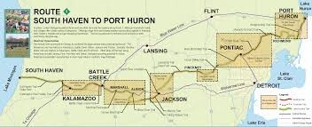
The original Lake Michigan to Lake Huron variation is about 280 miles.
----
Origins of the Great Lake-to Lake Trails Route #1
The catch phrase “Rails to Trails” is a concise description of the components of the Great Lake-to-Lake Trails Route #1. From the Kal-Haven Trail in the west to the Macomb Orchard Trail in the east, abandoned railways provide the basis for the creation of one the most iconic trails in the United States.
1840 – The Michigan Central Railroad was completed from Detroit to Kalamazoo.
1869 – The Kalamazoo South Haven Railroad company was formed.
1870 – The Michigan Air Line Railroad, owned by the Michigan Central Railroad, was completed from Niles in the west to Richmond in the east as a short line from Chicago to Buffalo.
1871 – The Kalamazoo South Haven Railroad company was sold to The Michigan Central Railroad.
1937 – Passenger service from Kalamazoo to South Haven ceased.
1970 – All rail services between Kalamazoo and South Haven and between Jackson and Niles ceased.
1990-2000 – The remainder of the Michigan Air Line Railroad ceased operations.
Today the old Kalamazoo South Haven Railroad is now the Kal-Haven Trail and the original Michigan Air Line Railroad is now the Falling Waters Trail, Mike Levine Lakelands Trail State Park, Huron Valley Trail, Michigan Airline Trail, West Bloomfield Trail, Clinton River Trail and Macomb Orchard Trail. As new railways were built, groups like the Michigan Trails & Greenways Alliance worked to build trails on the ideally flat, abandoned rail corridors.
The old Michigan Central Railroad is still active as a part of Amtrak, serving southern locations from Detroit to Chicago.
Lake St. Clair variation
Editor's note: John Adams submitted this variation and made the case that the existing GLTL route is designed for bicyclists and is not appealing to runners because of substantial mileage on busy roads without safe space for people on foot. He created and ran this variation that crosses the state in less distance and with better routing for runners. This route is approximately 215 miles.
My initial idea was to follow the GLTL trail that’s available online for bikers. A huge thank you to those folks who provided an excellent basis from which to design a do-able route which would be safer for running, and cuts over 40 miles in total. The GLTL folks have an excellent website I would recommend checking out @ https://www.gltltrail.com/
Another substantial difference is the eastern section. The GLTL route follows a rail trail from Wixom to Richmond and then it’s all roadside from Richmond to Port Huron. I did not feel safe with that road section as a runner. It might be fine for a biker, but we are out there much longer. Anytime I could omit road, and replace it with sidewalk, I did, and I was able to omit a substantial amount of road by running the sidewalk (12 Mile Rd) from Novi to St Clair Shores. Problem solved. Sections I was not able to get to in person were analyzed via Google Earth, many times over. The GLTL map provided RED sections which meant potential danger to me. My job was to eliminate the danger from each section, or at least get much more comfortable with it. In most cases, I was able to re-route it to include sidewalks or paths. In sections that have no sidewalk options, I was sometimes at least able to find safer roads. I kept the likelihood of dogs in mind as well.
Comments
Can this be done either direction?
Yes
I am planning to do this trail eastbound.
Give it a go!
Hello!
I plan to try out this route in July 23-30th. I just wanted to get clarification on the route mileage... Looks like the original route was 277.7 miles, but the new "runner friendly" route to Lake St. Clair is about 215. Does that sound correct?
Thanks!
Sarah, yes, 215 miles appears to be the approximate distance for the Lake St. Clair variation.