The AHT (Adventure Hiking Trail) definitely lives up to its name. If you’re looking for a straightforward, runnable trail, you should look elsewhere. If you’re looking for adventure, route finding, obstacles and the pure joy of running in some crazy natural elements (at least, when the trail is runnable), this might be your new favorite run!
A note to start. This is a very hard trail to follow and I would think a GPS is mandatory. There are a lot of markers and the trail is well marked but it’s still very difficult to follow in my opinion. If it weren’t for my GPS, there is no chance I’d have stayed on trail. Especially during lower traveled seasons, there are times when the trail is so faint, you feel like your just running randomly through the woods (which is SUPER fun but you should be prepared). There are also a ton of fallen trees and brush which make it feel a little like bushwhacking at times and makes getting off course a little easier. I managed to stay pretty much on course except for a few times where I quickly realized I was on the wrong trail and backtracked. There are a lot of trails and the AHT isn’t always the predominate one. The hiking project has a GPX track you download. I used it and it worked great.
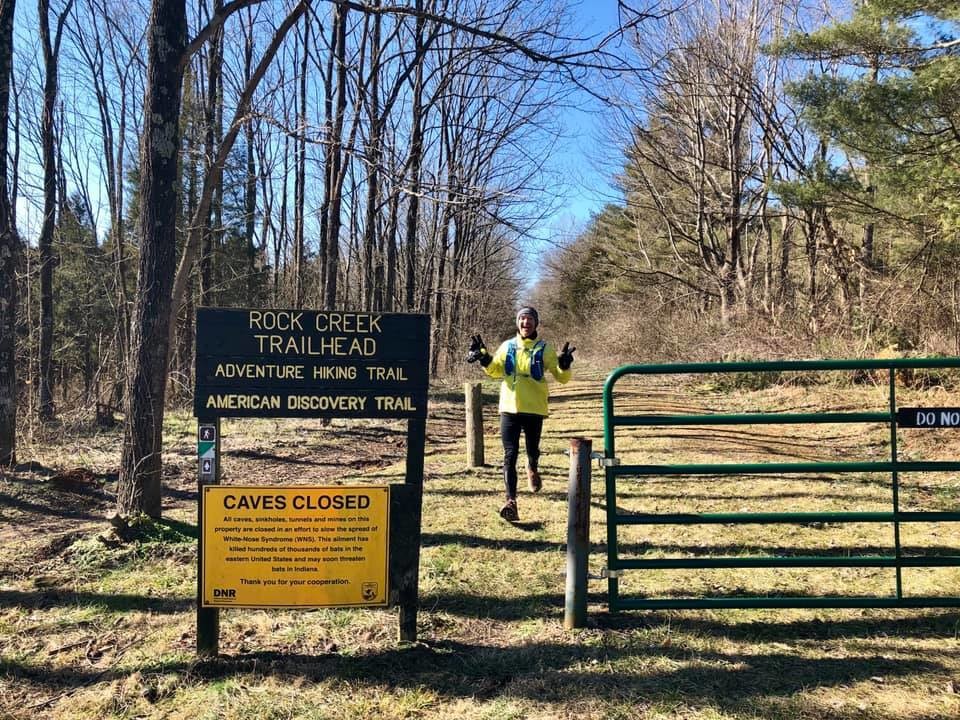
Where I ended up losing over a mile and getting frustrated was the out and back to reach the official AHT. Troy & Mike set the original FKT starting at the Rock Creek Trailhead (sometimes called the disabled hunters trailhead). I assumed it would be straightforward to the actual AHT but it wasn’t. Here is the right route for anyone attempting to break this in the future: You start running and within a few minutes will come to a spot where the Blue trail starts to your left. Turn here, don’t continue down the trail you’re on. That trail will head down to a dead end with a sign for “horse camp” indicating going to the right. Go right. The trail will initially start heading back the wrong direction, which caused me to second guess and run back the other way. Just keep following it and you’ll go the right way. The third navigation error I made was the follow the next sign to the horse camp. When you get to a spot where it tells you the horse camp is to the left and it follows essentially a dry rocky creek bed left, don’t follow that, stay straight. Once you hit the AHT, the GPX file will keep you right on or very close to the trail.
I ran this FKT completely unsupported on a Friday in January with a temperature of 8 degrees at race start. It was a beautiful sunny day with light winds but good gravy was is freezing. My hydration pack lines froze within 15 minutes, which was less than idea. My handheld hydration froze eventually too, and 8 miles in I had to stop for 3-4 minutes to rotate using my tongue and finger to melt the ice in the nozzle. It had also rained/snowed a ton in the preceding days, so the trail was frozen mud and occasionally you’d actually hit a spot that wasn’t frozen and my feet would sink to the ankles. I ran counter-clock wise and about mile 6 or so you get into some lower elevations and if it’s rained recently, there is a good amount of standing water. I tried as much as possible to keep my feet dry since it was 8 degrees out but it proved futile.
The trail itself is amazing. When it goes up, it often goes straight up a dry creek bed or area of runoff. The terrain can be very rocky and downhills are often straight down. It a blast for a Michigan flatlander to have this kind of terrain. I underestimated the terrain. The vistas however, were worth it. I want to go back when I’m not in a hurry. There are several times you run up a bluff and get expansive views of the Ohio River or tributaries running the length of a valley. It’s really a stunning place to run and I’m so glad I got the experience to be here. The tributaries cut into the rock and create some really cool rock formations that ice over in the winter, just stunning.
The first two miles of the run, I was really frustrated with route finding the terrain being more than I expected but once I just embraced what it was, it was one of my favorite runs ever. I wanted to hit a good time but you almost have to let time go and just have fun. There are so many downed trees and sections of straight up rock where you have to hike instead of run, that you’ll enjoy this so much more if you just relax, breathe it in and have fun. I’m definitely encouraging those in search of an epic adventure run in the Midwest to head out here.
I ended up with a time of 5:27:02, a little over 11 minutes faster than Troy’s time. It probably would have been sub 5:10 If I hadn’t gotten so off course a few times in the beginning and constantly have to backtrack (you can clearly see the 3 biggest backtracks in the GPS file). I have the Jackpot 100 in 3 weeks and was using this as a serious long run to get time on my feet and toughen up. I gave a good, hard effort but didn’t “race” it. Someone with an adventurous spirit can definitely come in here and go sub 5 and I hope more people do.
Comments
Josh, nice run and great write-up! It takes a bit of work to love this trail, and you clearly put in the work.
For those tackling this route in the future, a few words of advice:
Great work Josh, and thanks for helping to raise the profile of this route. I think it's a Midwest jewel.