


I had initially told myself I’d take it easy after running Eastern States 100 in August. That lasted about six weeks before I started getting bored and looking for a new project. I checked my calendar and my wife’s, and managed to carve out an eight-day block in late November. A friend had thru-hiked the Pinhoti Trail the previous year, and I’d had my eye on it for a while since it falls into my 300-mile range. Late November felt like the perfect time to give it a go. The Sunday before I was planning to leave (four days before my start), I came down with a pretty serious viral infection. High fever, chills, severe lethargy. My watch showed my HRV was through the floor, and my resting heart rate was elevated. I was tempted to postpone the trip, but my flight was non-refundable, so I figured worst-case scenario I’d just leisurely backpack as far as I could and then head home.
As a disclaimer for all of my FKT trip reports: this is essentially a stream of consciousness from what I can remember. I’m usually still in recovery mode while writing these, so gathering my thoughts is a challenge. I also don’t go back and proofread—so please forgive any grammar, sentence structure, or tense inconsistencies.
Day 1
Distance: 62.18 mi
Elevation: 8,829 ft
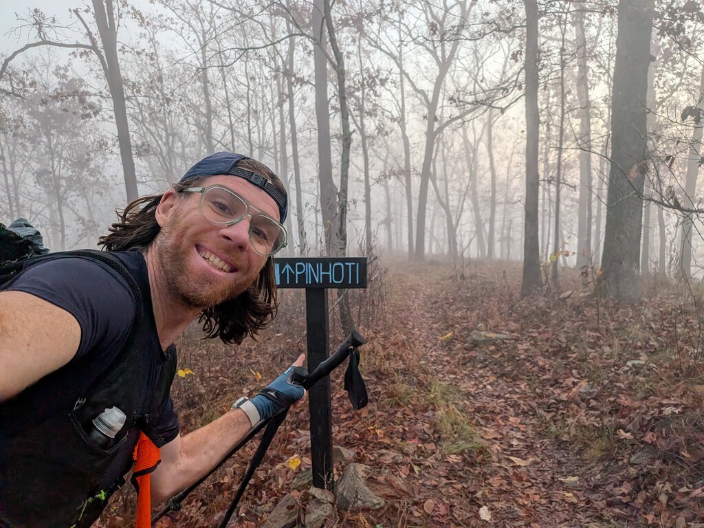
I got a ride from my motel to the Southern Terminus at Flagg Mountain by Nathan at Pinhoti Outdoor Center. Nathan had helped me tremendously with planning the logistics of my attempt and it was great to finally meet in person. It was a quick ride and I wished it was about 10 times longer because we could have chatted forever. Nathan dropped me off on top of the mountain in the fog just before sunrise, wished me luck, shook my hand, snapped a picture and sent me off.
I walked the trail to the top of the mountain, snapped some pictures of myself at the tower and quickly started walking. I immediately noticed that the forest here smelled different. It's impossible to describe smells, but it was a dry pine unlike anything I've ever experienced before. It was much different than then my previous Superior Hiking trail FKT ithis past June with moist boreal pines of Northern Minnesota. The sun began to peak over the mountaintops and shine through the foggy mist. It was beautiful.
I quickly had my first encounter with a giant spiderweb and bright yellow spider. Apparently the invasive Juro spider has infested the area and is weaving its web all over the place. I cannot count how many of these webs I encountered on the trail. The tensile strength of the web is so strong that it almost springs you backward. I developed a technique of breaking the bottom right web to sneak through, and then using the momentum from the large spider to swing it away from me. By now I'm used to eating lots of spiderwebs on the trail, but these giant spiders were admittedly a bit terrifying.
I made great progress down the mountain and was running quite a bit through the woods. Easy tread, pretty flat. I eventually hit the road and was on that for about 11 miles. Jogged as best I could when I could. Lots of dogs barking, some would run over to check me out, none bother me or come within 10 feet. No aches, no pains, no serious blisters. Everything was going as planned.
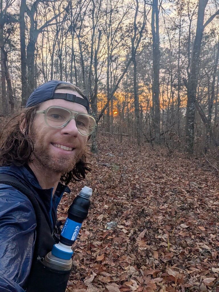
The sun set early at 4:40pm, and I knew I was going to have a lot of time night hiking on this FKT. Sunrise wasn't until 6am so a full 13 hours of darkness.
The only challenge for day 1 was the long 27 mile water carry. Nathan had scouted out a spring at mile 40 that was dry, so I knew I'd need alternate plans. I reviewed a topo map before I left and saw a spring just East of Bulls Gap. Once I reach the gap, I dropped my pack, ran the 1/3 of the mile down the road, found the spring, filled two liters and ran back. I passed about 10 water caches, but obviously I couldn't use those on this FKT.
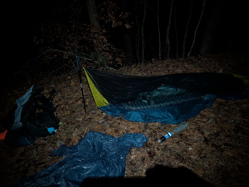
Made it to my planned camp and set up for the night for my 1 hour nap. Somehow I stopped for a full 2 hours and 10 minutes, which was 30 minutes longer than I had planned.
Day 2
Distance: 45.36 mi
Elevation: 8,133 ft
Sleep previous night: 1 Hour
I woke up quickly and wasn't too confused. I started walking and felt alright. However, as soon as the sun came up, which is when my brain normally switches back on, something wasn't right. I felt a weird malaise, down, depressed. I just didn't have any energy. This isn't normal for a 2nd day of an FKT. I pushed through it, but I think it was related to the viral infection I was recovering from. My body just wasn't at 100%, which it needs to be for an exertion like this.
I eventually started to hit the rocks as I approached Cheaha Mountain. They were much more intense than I was expecting and quite relentless. I think it was at least 10, maybe 15 miles of rocks on the same level as the Pennsylvania Appalachian Trail. This is not my strong suite, and my pace was incredibly slow. I kept seeing it tick slower and slower. 24 minute miles, 25 minute miles, 26 minute miles. This was the slowest pace I've ever had on any FKT. I just couldn't move fast.
I was frustrated and my mood was extremely down. I was tempted to quit and just stop for the day but I didn't really have anywhere to go, my flight home was booked a full week away, so why not just keep moving for now.
To make things worse, I checked the weather and a huge storm was headed my way. Lots of thunder and lightning. This weighed on me for hours as I was along a ridgeline the entire time. However, the storm somehow split and half went North of me and the other half South, completely missing me. Such luck.
I finally exited the rocks almost exactly at sunset and I was MANY miles behind schedule. I had planned for 22 minute miles this day, so I was a full 2 hours behind. I decided to stop 3 miles earlier than my planned itinerary. I knew day 2 and 3 would be the roughest because they had zero road miles where I could make up time. Of course, right before I reached camp it started to downpour so I had to put on my rain gear and everything got soaked.
I stopped at 3 Magnolia's Camp, set up my tarp and lied down for 3 hours.
Day 3
Distance: 46.30 mi
Elevation: 6,978 ft
Sleep Previous Night: 3 Hours
I woke up, packed up my gear and of course the second I started walking it started to rain. It downpoured in the darkness. I crossed the interstate I drove the few days prior. As the sun rose, the rain stopped which was great. Very pretty walking next to some streams and rivers and around some lakes. The tread was much easier today. Pine straw and much less rocks.
I was making better time, but not great. 24 minute miles. I just couldn't move fast. I felt like something was wrong but couldn't put my finger on it. I just didn't have the energy.
Fortunately Nathan had warned me that Dugger Mountain Wilderness area wasn't blazed well, so I anticipated that. Up and over the mountain in the middle of the night, down the other side. It felt like it took forever. I somehow always manage to be up along ridges or mountains in the middle of the night.
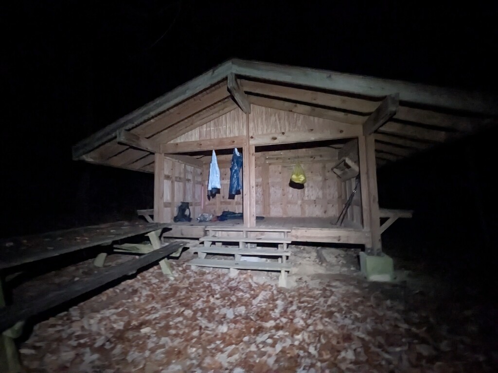
I was originally supposed to go all the way to Oakley Mtn Shelter but I just couldn't do it, so I stopped at Dugger Mountain Shelter. The sign said 1/4 mi to shelter. I was bummed because I thought it was right off the trail. I took about 50 steps and bam, there was the shelter. That was not a 1/4 mile and I was fine with it.
I set up my stuff in the shelter and lied down. I was in the absolute middle of nowhere and it was pitch black. All of a sudden I could hear the bass from some serious sound system. Someone, somewhere, out in the forest was having an EDM party. It was a super subtle bass, but I could feel the rhythm. The shelter was only 1/4 mile from the dirt road so I really hoped they didn't mess with me. I was only there for 2 hours, so I didn't think they would.
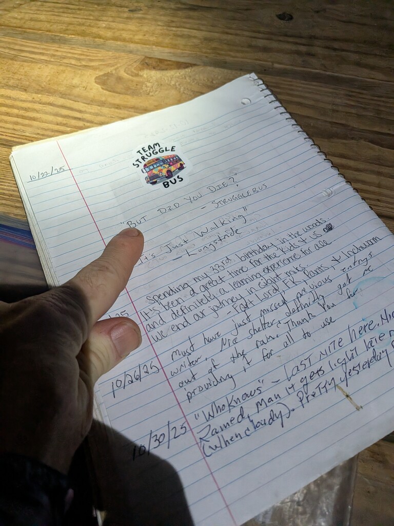
I wrote an incoherent entry into the log book and immediately fell asleep.
Day 4
Distance: 58.17 mi
Elevation: 7,379 ft
Sleep Previous Night: 3 Hours
Woke up, taped some sore spots on my feet, popped some blisters, lubed up. Started walking in the dark and was making pretty slow time. Some pretty decent elevation in this section of trail. Made it to Oakley Mtn Shelter at sunrise so it was good I stopped when I did. Kept pushing on and making the best time possible. Lots of unmemorable miles for some reason.
Popped out at a road, short road walk, back into the woods and hit a short wildfire burn section. Finally hit my first sign with a distance to the end of the trail - 171 miles. over halfway! Up over a mountain with lots of rocks. Very excited to get this over with. Down the backside and much easier walking.
Finally crossed into Georgia! Snapped a few pictures. Sun set and I knew I was approaching the long 23 mile road walk. Right before the road, I hit one of those bigs signs that shows you the distances to all different points of interest. North Pole, Key west, Mt Katahdin, etc. It was pointing to the Benton MacKaye trail in the wrong direction, South of where I was standing. I was confused. Hallucinating? Not yet. I still can't answer that one.
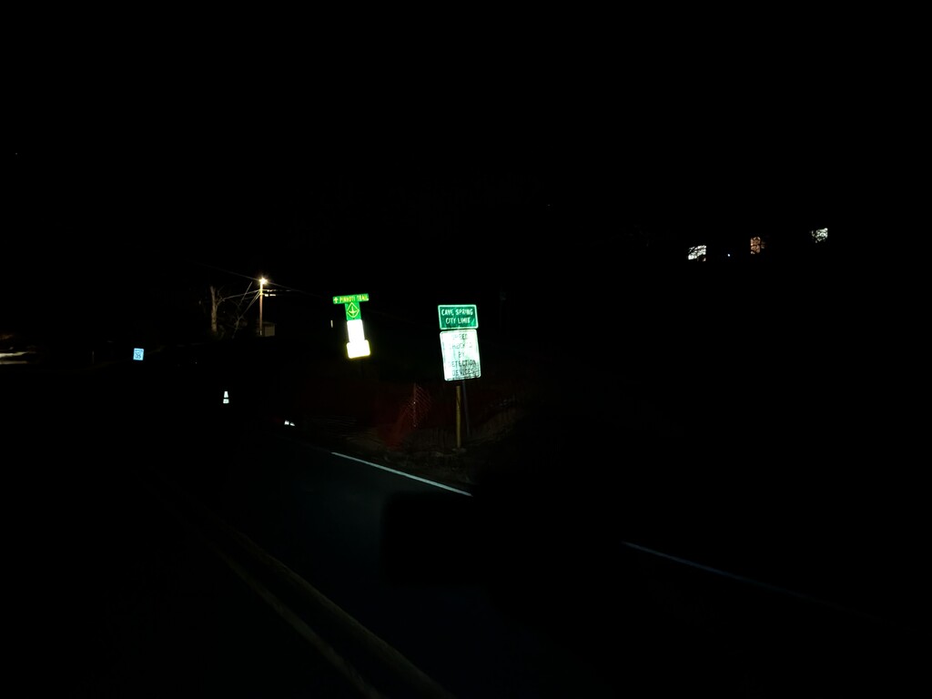
Hit the road and realized it was going to be a pain. Lots of switching sides of the road, jumping off the side. It was dark and rush hour, 6pm, so not idea. I finally made it into Cave Spring, filtered some water, cold soaked food and quickly left. Pretty town, decorated for Christmas. Made me wish I was on a normal thru hike and got a zero to chill in town. Not this time.
I eventually ended up on this insane 4 lane highway at like midnight. Trucks raging past at 70mph. It was rough. I heard sirens in the distance. Kept walking on the shoulder. Out of the corner of my eye, I see a car with 'Sheriff'. Here it comes...how am I going to get out of this one? Am I even doing anything wrong?
He swings around and turns his lights on. Yells across the median. "Hey, whatcha doing over there?" "Oh, I'm hiking a trail" "You're on a trail?" "Well, I'm trying to get to the trail" "You want a ride?" "Nope, I'm good, thank you" "Ok, well, you be safe, alright?" "Yes, thank you for checking on me. Have a safe night!" Easier than expected.
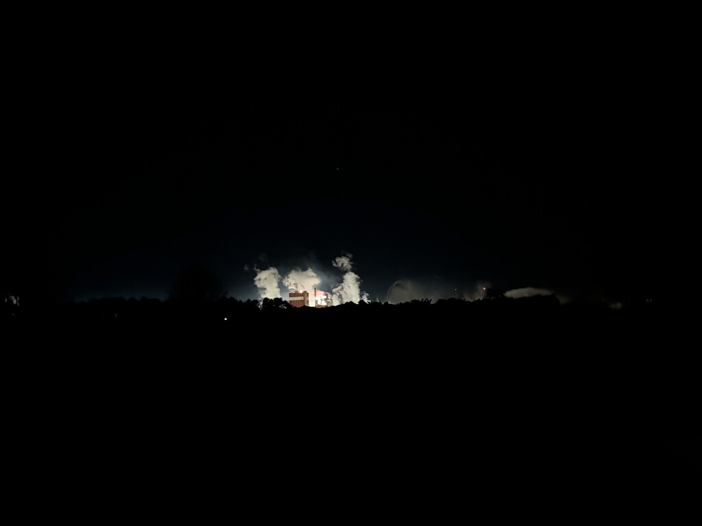
Next encounter was with a giant paper mill. This thing seemed post apocalyptic. It was bright white glowing with steam billowing, sounds crashing, all sorts of chaos. It was terrifying and I just wanted to get past it. All of a sudden, a shooting start streaks across the sky. That was real.
Finally I'm down off this insane highway onto a surface road in a town. I see a person out of the corner of my eye so I avoid looking that way. I start trying to cross the street but a car is coming. I finally look and it's me - my 3D shadow is following myself. First hallucination of the FKT. I just sort of watch it float along in front of me. Not sure where the shadow is coming from, but it's definitely there. I really wasn't in the mood to hallucinate this FKT so I did a pretty good job of avoiding it.
I turned off the main road onto a smaller road. Lots of dogs barking, none bother me. I finally reach the rail trail. My feet are aching from the 27 miles of road. I know I have another 12 miles of crushed stone rail trail in front of me. I've been walking for 21 hours and it's 1:15am. I figure I'd make better time if I got some sleep. Quickly set up my bivy, fall asleep within minutes.
Day 5
Distance: 52.10 mi
Elevation: 6,644 ft
Sleep Previous Night: 2 Hours 30 minutes
12 cruisey miles on the rail trail to start the day. "Pancake Flat". Many more miles, not a lot of memories for some reason. Up on a ridgeline for most of the hiking, very easy, lots of leaves, flat and cruisey. Making really good time, 21 minute miles. I just sort of turned my brain off this day and banged out the miles.
Finally came down off the mountain to a stream and saw a car campsite. All of a sudden the people sort of scattered. I walked past and the fire is going, cooler is open, stereo is turned on, I'm a bit confused. I start road walking and about a 1/2 mile down the road I see a headlamp IN the creek. I shine down to see what's going on and a 12'ish year old kid yells back "Hey, Mister, are you a hunter?"
I laugh. "No, I'm a hiker". "Oh, okay, well, I'm sorry!" "No need to apologize! Have a great night!" Still not sure what that was about.
Short road walk, back into the woods. Feeling really good at this point, approaching my weird euphoric states. Trail is super smooth and easy to traverse. Up and over Johns Mountain lookout tower. Down the mountain, which is a bit rough but not unbearable, made it to Pilchers Pond, headed up the trail a bit to get out of the wind, threw down my bivy and fell asleep immediately.
Day 6
Distance: 90.37 mi
Elevation: 12,694 ft
Sleep Previous Night: 2 hours
My alarm went off and it was pitch black. I had no idea where I was, or what I was doing. Took a few minutes to get my bearings. Assessed my feet, popped some blisters, taped a bit, applied desitin because I was expecting rain. Starting hiking and as expected, torrential downpour started right at sunrise. I got soaked and was up on a ridgeline while it was downpouring but fortunately no thunder/lightning. I'm 90 miles from the end. I text my shuttle driver Ron "I'll be there at 2pm tomorrow. See you then". Pretty confident estimate...
The rain eased but still misting and drizzling until I made it to the 27 mile road walk into Dalton, Ga. Started the road walk and the rain stopped. Took off the rain gear. Rain started again, put rain gear back on. This cycle continued about 7 times along the road walk.
My headlamp battery was fully charged, so that was good to get me through the final night along with my watch and my Garmin inReach, but my phone was critically low and I had no battery bank left so I decided to stop at the Brookward Park to fill water and charge my phone. My water filter has also been slowing, so I decide to do some vigorous backflushing. I meant to spend 20 minutes there, but somehow spent about 45. Not awesome, but it is what it is.
I re-taped my feet but when I started walking they felt weird so I had to keep stopping. Wasting more time stopping when I should be making up time on the road walk. Frustrating. At least I'm on a sidewalk. So many great smells from fast food joints. It's torture. I'm so tired of consuming my cold soaked food. I just want a burger.
Eventually I leave the sidewalk and start walking on a very busy, very narrow road with absolutely no shoulder. It's 5pm, so rush hour on a Tuesday. Every few minutes I have to jump off the road to let the car pass. Not only am I not making up time, I'm losing time because I'm stopping so frequently. It becomes dark and now it's raining, so cars can barely see me. This is an absolute nightmare I endure for hours.
Finally I reach Chief Vann Historic Site and finally filter water for the first time since Brookward Park. When I start filtering, I notice there's air coming out of the threads in my Sawyer Squeeze. I unscrew the filter and realize the gasket is missing. It must have popped out when I backflushed at Brookward Park. Fortunately, I have a spare gasket in my first aid kit. I pop in the new gasket and realize it's somehow a little smaller than the previous, so I can't screw it down completely or else it gets sucked into my water bottle. Annoying.
More wasted time... Whatever, only about 40 miles to go, I can't deal with this now. I'm starting to zig zag all over the road and finding my direction is tough because I'm so tired. I just need to make it to where the trail gets back into the woods so I can lie down for a minute. I finally make it, take about 5 steps off a very quiet country road where I haven't seen a single car in 40 minutes, throw down my bivy and of course, a car shines its lights right on me as it drives by. Again, whatever, I'm lying here for 30 minutes. It doesn't matter.
I lie down and set a timer for 30 minutes (alarms are too confusing so I'm just using timers now) and no quilt so I'm not too comfortable. 30 minutes passes, alarm goes off, I snooze for 10 more and grab my quilt for 10 comfy minutes, get up and pack up. It's the final 40 miles all on trail. I've got this.
I start moving and say over and over "I'm going to be fast. No 25 minute miles. I need to meet Ron by 2pm" The trail is super cruisey, wide and flat. I'm seeing the splits tick off my watch... 19 minute mile, 21 minute mile, 20 minute mile, I'm maintaining the pace I want to and I'm super happy. The fog is so thick though, I can barely see 3 feet in front of myself. It's now about 4am and I'm starting to get tired again. I'm falling asleep while walking. I'm losing spatial orientation because of the fog. Am I going uphill or downhill? I feel like a pilot flying a plane in a cloud. Which way is the earth?
I decide to lie down in the middle of the trail, on the cold wet dirt and I set a 3 minute timer. Back up and moving, feeling slightly refreshed. an hour later, I'm falling asleep walking again. Then, all of a sudden, my watch is buzzing telling me I'm off course. I look up and I can see blazes right in front of me. The GPX track must be wrong. I keep walking. It keeps buzzing.
After about 10 minutes I look at my watch and I realize that I'm somehow walking in the WRONG direction. I zoom out on the map on my watch and I've been walking in the opposite direction for over a half mile. HOW DID THAT HAPPEN?!?! I start running North, the correct direction and finally reach the spot where I turned around. It's just a typical switchback. Did I sleepwalk off the trail into the brush, turn around, see the trail going uphill and then take the route that I came down because I didn't remember walking there?! I have no idea, but I'm really annoyed because I wasted at least 25 minutes of this back and forth.
At least now I'm wide awake. The sun eventually rises and sort of jog walking as fast as I can. My pack feels like, I can actually move. I realize how absolutely beautiful this section is and I enjoy the last few miles. I continue making good pace and push on through the final miles. Of course, these final miles are the toughest with not a lot of maintenance and three good elevation gains, with the final 1400' being the single largest gain on the entire trail.
I reach the final summit and start heading down. I've got 2 miles to go. All of a sudden, my watch which had 4% still left dies. Whatever, I've got my Garmin inReach tracking me. I run the remaining 2 miles downhill and reach the final sign for the Pinhoti Trail Northern Terminus. I take a screenshot of my phone clock to mark the time. I'm at the spot where I was less than a year ago when I attempted the FKT on the Benton MacKaye Trail. It looks familiar. I sit down, take a breath, smile and pause for a minute. I then start walking back up the trail to the road.
Exactly 90 miles prior I had texted with Ron's AT Shuttles to meet me at the Pinhoti Trailhead at 2pm. I'm impressed with my punctuality. I hate being late. I pop out of the woods at 1:51pm and I can see Ron coming down the hill in his 4Runner. He splashes through the creek, jumps out and says hi! I immediately love his energy. I'm ready to sit down and chill for a bit, chatting with Ron if I can stay awake. My brain is scrambled and I'm ready to just stop pushing onward. I warn Ron that if I stop talking and my chin is on my chest, it's okay.
Ron is the best. He got me to the hotel at the Atlanta airport at 4:30pm. When I arrived, the hotel staff announced that my wife Lara had ordered two pizzas, a dozen wings, a tray of brownies and two 2 liter soda's for me. I brought them up to my room and instantly ate one of the pizza's. I took a shower and passed out by 7pm. Woke up at 4am for my flight, was on the plane at 7am, back in Philly by 9am, Lara picked me up at the airport (such an amazing feeling seeing my family pull up, my little girls huge smiles) and we were at my inlaws for Thanksgiving at 10am.
Special Thanks
My wife, Lara
Training for these FKTs takes an enormous amount of time, and she shoulders so much when I’m gone for eight days at a time caring for our two girls. This one demanded even more—she was working, juggling everything right before Thanksgiving, and still managed to coordinate care and keep everything running smoothly at home. I truly couldn’t do any of this without her support.
She’s also the only one who knows exactly what to say to walk me back from the edge—and during an FKT, I find myself on that edge more often than I’d like to admit. I’m incredibly grateful for that.
Pinhoti Outdoor Center – Nathan
Nathan was instrumental in helping me get the logistics dialed in. He even scouted a ridge-line water source a few days before I started—something that turned out to be incredibly important. I can’t say enough about how grateful I am for his help. I wish our drive to Flagg Mountain had been four times longer.
Ashlie Ithurburn
Thank you for taking nearly an hour to talk through your epic supported FKT and for sharing your insights. I relied heavily on that wisdom out in the woods.
Jason Wish
Thank you for being a sounding board and offering guidance on all things FKT, and for sharing your experience from your Pinhoti thru-hike last year. Your input made a real difference.
Matt Benefield
Thank you for sharing updates and encouragement in the group throughout the attempt. It was incredibly motivating to see the community so involved.
Luke McCrae
Thank you for creating an amazing website that allowed the community, friends, and family to follow my progress. Truly appreciated. Check out Corsa.run!
Will Daniels
Your day-by-day breakdown of the route—what to expect, what to watch out for, and how to be mentally prepared—became my Pinhoti Compendium. I read it twenty times. Thank you for all the guidance, encouragement, and patience with my endless questions.
Ron’s Appalachian Trail Shuttle
Thank you for getting me back to my family in time for Thanksgiving. I needed a reliable pickup window, and Ron delivered—even shifting the time from 11 a.m. to 2 p.m. on short notice. Our ride back to Atlanta was a delight, even with my barely functioning brain. Grateful for his flexibility, kindness, and good company.
If I forgot anyone, I sincerely apologize. My brain is still operating at about 60% after this effort—names, dates, basic vocabulary all floating somewhere out on the trail. If I missed you, please know it wasn’t intentional, and I appreciate you.