Thanks to my wife Anne and my children Mira and Maisie and all the friends that supported me to make this dream become a reality. This was my first through-hike attempt.
Some brief background: last July my friend Chris Fisher connected me with Jason Hardrath. I was finishing the Colorado 14ers and Jason was doing the Rocky Mountain Slam - all of the CO 14ers, the WY 13ers, the MT 12ers. We spent 3 days together doing the 7 Elks 14ers outside of Aspen. Along the way I also met and hiked with Nika "Early Bird" Meyers (Long Trail, CT FKTs) and Josh Perry (Long Trail, AT, PCT FKTs). I talked with them a little about fast packing through-hikes and I was completely fascinated. Multiday FKT attempts had never appealed to me but I was intrigued. Fast forward many months and I became determined to make a speed attempt on the CT. Before the attempt I also talked to Kyle Curtin (supported FKT on this route) and David Ruttum (self-supported FKT in the opposite direction).
Here's my recap while it's still fresh and not completely garbled.
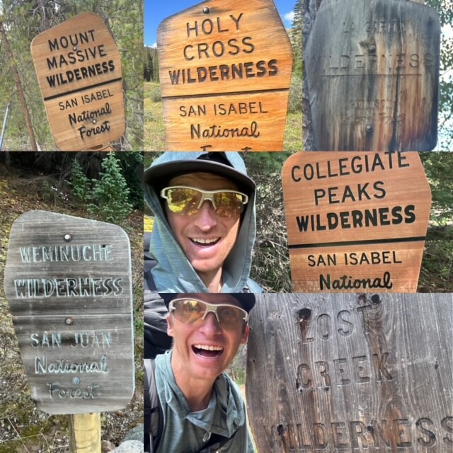
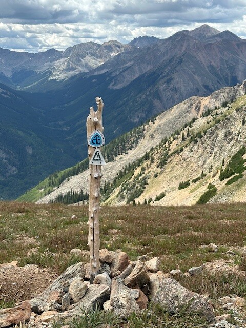
Day 1 (Aug. 11): Waterton Canyon to Lost Creek Wilderness, Segments 1-4
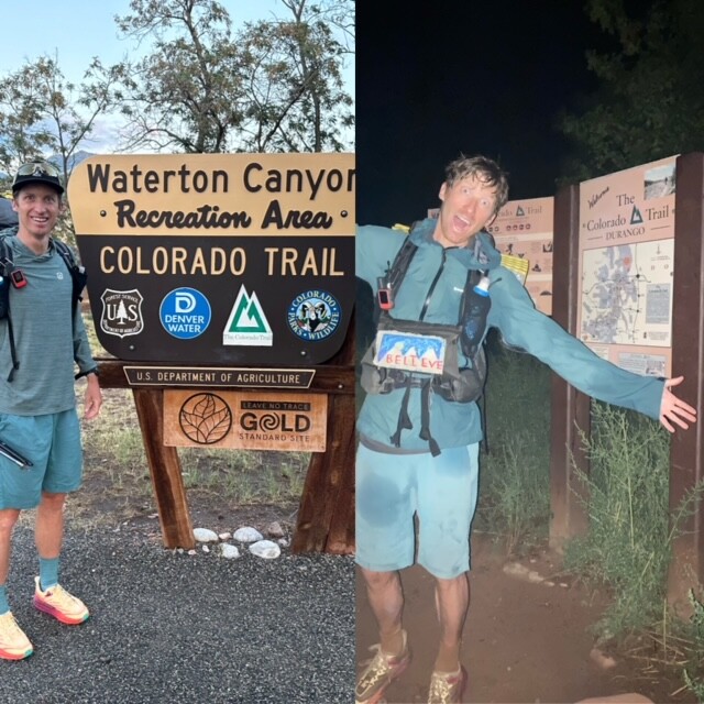
Like a doe-eyed freshman, I didn't really know what to expect but I was as ready as I'd ever be. My friend Mike dropped me at the Waterton TH at 6 and I was on the trail at 6:13. I cruised on this day. The weather had been overcast but dry ideal for stacking miles. And I probably stacked too much. 51 miles in, shortly after midnight I decided I should try to sleep even though I wasn't tired. I was through the first section of Lost Creek Wilderness and just threw up my shelter on the side of Brookside McCurdy because I thought it might rain.
Day 2: Lost Creek Wilderness to Summit County, Segments 4-6
I had trouble sleeping because although it never rained, the wind was howling and so my tarp shelter kept flapping. I was moving again by 330am. Bit of a mistake to go like this at the outset but the miles were flying by. I came to my first cache at Kenosha Pass midday. I unburied it and sat down to enjoy some calories when I realized I was profoundly exhausted and it was only noon. I tried to sleep for 20 mins and got back on the trail going for Georgia Pass. On the way there, the high sun and late day heat started to drain me. By the climb up Georgia Pass, I was near some hike-a-bikers (doing the CTR) that I was jockeying with on the climb. Normally that would be fun for me. Instead it just annoyed me. I knew I was getting cranky and grumpy from the sleep deprivation. I laid down on the trail halfway up the climb. After a few minutes I got up and finished the march up to the pass. On the way down I still felt profoundly exhausted and it wasn't even 4p. I got to the bottom of the climb and setup camp in an unoccupied campsite and just laid there. I'd made little progress for the day compared to the previous and was unmotivated to move forward. I texted my doubts on doing the rest of the trail with my wife on my inreach. She basically said "You got this. Get up. Now." That worked. I threw everything back in my pack and soldiered on. I climbed over West Ridge (east Breck area) in the dark at 9p but after that I was ready to sleep. Immediately. Instead of finding a campsite I just found a small flat area at the edge of a switchback. Threw down my ground sheet and sleeping pad and conked.
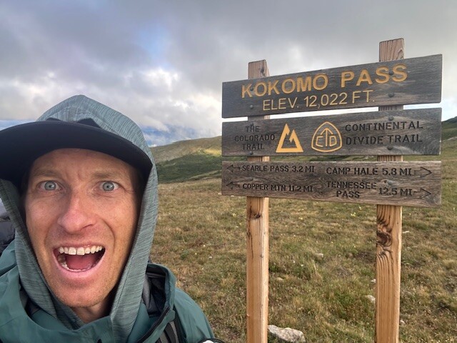
Day 3: Summit County to Tennessee Pass, Segments 6-8
First I was awoken shortly after midnight by one of the CTR racers lights. Because I was on the edge of this switchback practically on the trail I sat up and yelled "Please don't hit me!" to which he just casually replied "I see you brother." I passed out again. Around 3a I was awoken by light rain and a star filled sky. Weird. Instead of scrambling to throw up my shelter I just tossed my ground sheet over me and slept another 3 hours. 8 hours of sleep was all I needed to start moving well again. I made my way down to Gold Hill, over the Tenmile and into Copper where I made a stop into civilization for a giant bowl of pasta from the one of the generic ski village restaurants. Already my electronics were all running low on power. I sat next to an outlet to recharge everything and realized I'd be battling the constant power deficit for the rest of the journey. I felt elevated after eating real food and charged over Kokomo Pass. I met some hike-a-bikers along the way on Searle Pass and stopped at their campsite after dark to share a meal and charge electronics of course. They offered to let me stay there for the night but it was only 9. Even though that was late enough for me to crash the night before I decided I needed to get closer to Tennessee Pass and my next cache. I continued into the Camp Hale area. Around 11 I decided I wanted to sleep. However, the area has a steep grade to it and campsites are at a premium. I passed 3 occupied campsites cursing more loudly with each one I passed. Finally I emerged from the sloped section of trail to a flatter area. I just threw down my ground sheet to sleep under the stars.
Day 4: Tennessee Pass to Mt Massive Wilderness, Segments 8-10
Again, it rained that night. Harder this time. Did I scramble to erect my tarp? Absolutely not. I threw that ground sheet over myself again and made do sleeping until 6 despite the rain. I reached my cache at TN Pass that morning by 8. Since I hadn't been using it, I left my tent with this cache. I continued into Holy Cross Wilderness and it completely arrested my steady forward progress. Steep, rocky trails abound. By the time I eased into Mt Massive Wilderness later that afternoon my feet were thrashed. The CT portion of Mt Massive is all below treeline and fairly unremarkable offering little in the way of distraction from pain. I stopped repeatedly to soak my feet offering only fleeting reprieve. I aspired to make it to Twin Lakes but that was a pipe dream. Instead I crashed at sundown in the campsite at the southern side of Mt Massive Wilderness.
Day 5: Mt Massive Wilderness to Lake Ann Pass, Segments 10-CW02
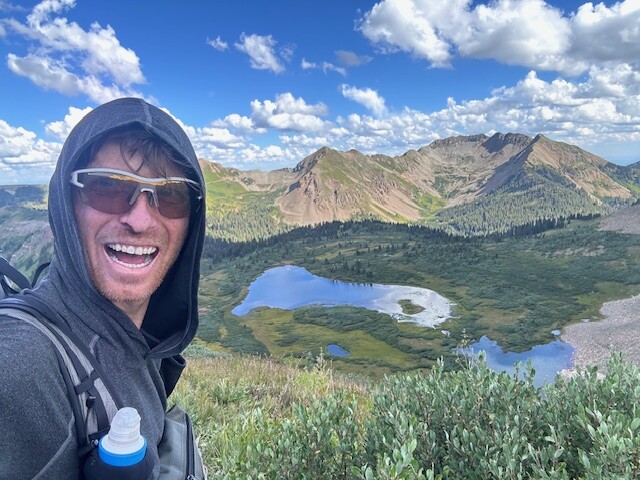
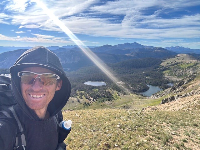
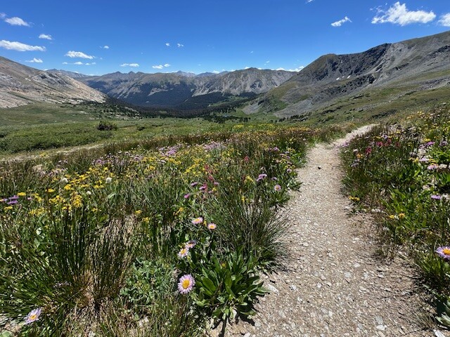
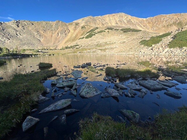
This might come as a shock but... it rained. I had grown tired of rolling my ground sheet over myself with the nightly rain because I couldn't cover my head with that. I adapted by tying para-cord between two trees as insurance for nightly rain. When it happened at Mt Massive, I draped the ground sheet over the cord creating a tent of sorts. This worked pretty well. I woke up despite that shortly after the rain began and started hiking about 3a. I wanted to make up for some of the progress I'd sacrificed with my sore feet the day prior. I traced my way through part of the LT100 course passing the occasional Mt Elbert "mountaineer" asking "Already done?" No, dude... I still have a few hundred miles left. "Huh? You didn't go up Elbert?" Since the official CT route doesn't go through Twin Lakes but rather AROUND the lakes, I forewent the opportunity to resupply at the town of Twin Lakes that morning and started making the stroll around the lakes. Surprise, surprise most of my electronics were low on juice. As I was passing by the Colorado Fourteeners Initiative compound I saw a guy emerging from a yurt holding a power jack. Tyler kindly allowed me to interrupt his morning and sit there in the CFI parking lot to charge my gizmos and make an oatmeal breakfast. I continued on around the lakes coming to the CT Collegiate East/West split and a section where the regular CT was rerouted because of the Interlaken Fire. Perfect excuse to hop into the well preserved Interlaken Historic Resort House. Such a cool spot at the lake's edge. I toured the house feeling more invigorated to continue on to Hope Pass. As I started up Hope Pass I realized I only had about 1500 calories remaining for my remaining trip to my next cache at Cottonwood over 30 miles away. A friend texted, 'should be no lack of hikers to mooch from along Hope Pass'. This proved right. I asked several randos if they had any calories to spare. One man crewing the LT100 provided me a gel but I really hit pay dirt with some women on their way to Twin Lakes for a wedding who were finishing a section hike from Cottonwood Pass. Since it was their last day they gave me everything they had which amounted to two full bags of trailmix and several protein bars. Moving on with a heavier pack I made it into the Collegiate Peaks Wilderness and the basin below Ice Mountain. This is easily one of the prettiest places in the Sawatch and Colorado. I started up toward Lake Ann Pass with low energy levels (probably directly tied to my 3a start). I ate a bunch of the trail mix and took a short nap. When I woke I realized my right foot was in agonizing pain and looked down to see a massive blister on my right pinky toe. It came with hiking in the rain over the previous days. I gave it a half-assed wrapping job but I still had to basically hobble as I hiked. I encountered two women coming down the trail and asked if they had neosporin. Not only did they have neosporin but they were both nurses in possession of a tricked out first aid kit. They took a look at my toe and just said it was heavily inflamed, not infected, needed to be dried out and needed to have separation from the adjacent toe while hiking. This choice encounter helped me to continue on to Lake Ann Pass shortly before sun down. I made it onto the new section of the CT there at sunset high above Texas Creek below. It's a pleasant trail that contours the alpine along rock bands and high meadows. Here I made camp beneath a large old growth pine around 10p.
Day 6: Lake Ann Pass to Boss Lake, Segments CW02-CW05
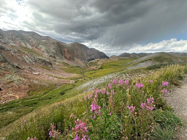
NO RAIN. Or maybe it did rain? I'm not sure but the giant old pine provided enough protection that I slept great. I arose at dawn after 8 uninterrupted hours of sleep. I continued on along the new trail as it dipped down to Texas Creek. There I made the stout climb up to Cottonwood Pass and my third cache. I had it hidden in a heavily trafficked area full of tourists. One man asked, "where'd you find them goodies?" Told him I had placed them here for a through-hike and he could not comprehend this concept at all. Then he departed in his giant SUV rental. After the much needed refuel I started into the highest segment in the Collegiate West. And it's breathtaking. Views for days on superb (i.e. not much loose scree) trails winding through big mountains, fields of flowers and tranquil streams. I loved this segment and the Emma Burr area in particular. I continued on to Tincup Road and made the climb into Wildcat Gulch. This segment was pleasant but just didn't pack the same awe-inspiring punch as CW03. I descended from Wildcat down to Tunnel Gulch - where the CT runs flat along an old railroad. Each of my inreach, watch and phone were low on power so I was contemplating how I was going to deal with this when I happened upon a group playing cards right in the middle of the trail. I told them there was no need to move and they said they weren't planning to anyway. Sounded like a group whose company I'd enjoy. I implored about a battery bank and they kindly obliged. I made a meal and hung out with them for awhile. They were a father-mother-son trio from Minnesota and doing the Collegiate Loop. When they asked how long I had been through-hiking and I told them a few days they thought I was insane. The mother, trail name Goose, asked my trail name. I explained I hadn't been out there long enough to receive one and without skipping a beat she said, "You're mooching battery banks and hard charging through mountains... Charger?" Fitting double entendre. They invited me to spend the night there but I charged ahead over Chalk Creek Pass in the dark through some shifty talus and down to Boss Lake where I made camp above the dam beneath some aspens.
Day 7: Boss Lake to Sargents Mesa, Segments CW05-16
No rain. It was a heavenly night of sleep under the Milky Way. I slept late after the big day prior finally landing on the trail around 7. The sun was shining and the lakes were shimmering. I made a quick hot breakfast at a lake beneath the Banana Mountain cirque and then gained the ridge. The soft morning light made this an idyllic ridge run to Monarch. True to form, my electronics batteries were low (I never had time to fully charge everything). The top station of the Panoramic lift was unlocked so I discretely let myself in and spent the next 30 mins in this shack with my gadgets. I continued to the long awaited resupply at Monarch Pass Crest restaurant. This oasis completely elevated my spirits. I was already riding high but after having 2 burritos and a coffee, I felt like I was starting day 1 again. I began the gradual ascent up the crest trail not initially realizing it was Saturday. So many bikes. Even a few dirt bikers. I played leap frog with the folks hiking bikes through steeper sections. After a few hours I reached the apex of the climb where the Collegiate West route rejoins the East. I talked briefly with another through-hiker who was proud of his low pack weight. He claimed a dry pack weight of under 7 lbs. Asking mine, I explained that I'd guess 10 lbs give or take. Told him I had already jettisoned my tent to save weight but still had a stove. He couldn't understand how I was doing a speed hike with such a "heavy pack". Or how I was averaging 45+ miles per day. He said something like "that can't be right." We started hiking together but he dropped off after a little while. I made it to Marshall Pass where I had another cache hidden beneath a tree. But unlike the others, this cache included a massive 1 pound battery bank. Originally I was going to just charge a few things at the cache. Instead I decided the tradeoff in peace of mind was worth the weight penalty. I continued on toward Sargents Mesa. The rain came but it was fine. I don't remember much of this portion of the hike. I had an audio book on. The monotonous yet meditative pine forests seemed to continue forever. As the sun was descending over the horizon I went to turn on my headlamp but it was dead - odd since I'd been charging it. I thought maybe the battery bank was incompatible with my battery. I had backup AAA batteries but this was a wrench. I made camp in the dead forests of Sargents Mesa after continuing well into the night looking for a workable campsite. I laid down shortly after midnight beneath some propped up deadfall on a lightly rainy and windless night. But at 2am I was awoken by whistling wind shaking the sparse living trees in the vicinity. Dead trees don't bend, they just break catastrophically. There were silhouettes of widow makers in all directions. I tried to shake off the thought of getting smashed by a dead tree but it was impossible. By 230a I was back on the trail. I happened upon a biker around 3:30 with lights brighter then Data's chest lights in Goonies. I asked if he could plug my headlamp battery into his setup. It wouldn't charge. It was definitely dead. Shit. I'd need to mooch batteries. I continued on until around 4:30 when I collapsed in an area removed from dead trees. But then it started raining around 5. WTF. I did the routine burrito fold over with my groundsheet and slept another hour.
Day 8: Sargents Mesa to Eddiesville Trailhead, Segments 16-19
I awoke to an overcast sky. I was sore. I was tired. And I was unmotivated. I tried to change that with hot oatmeal. The previous night had been a debacle and I didn't get enough rest but I did hike a bonus 10 miles in the middle of the night. I had no idea where I was in relation to my caches. I just knew I had to make it through these creepy forests to CO-114 (Cochetopa Pass). Water is sparse in this area. Not necessarily because of the lack of streams but because of all the cattle tainting the few water sources that are available. I crossed streams twice deciding to continue on. Growing desperate, it wasn't until I descended off the mesa down to the Lujan Pass trailhead that I found a usable water source. I followed the trail along dirt roads for a few miles. Soon I was on pavement at CO-114 and my next cache. Shortly after the resupply, my collapsible pole shattered at the joints. I had duct tape in my repair kit patching together a workable walking stick. I was not confident I'd be able to talk a stranger into letting me borrow his poles for another couple hundred miles. The CT follows dirt roads for many many miles after 114. A storm rolled in a few miles past 114 and it continued raining for the next several hours. Trail magic with ice-cold canned seltzer was left along the dirt road where the La Garita CT bike detour splits. Standing there shivering in the rain with gloves on, I decided to pass. I found an old growth pine along one of the roads to shelter under that afternoon. I was over the rain and really sleepy. I took a 20 minute nap to reinvigorate me. With the second wind, I punched my way through the dirt road death march and started into the La Garitas. I found this area to be one of the prettiest in Colorado. It's remote, not often visited, and peaceful in that pastoral kind of way. The trail curves through aspen groves down into the Cochetopa Creek valley then follows oxbows full of beaver dams. I decided to have dinner along one of those when I saw moose chomping on willows on the other side of the creek. This was one of the highest highs of my trek. Reluctantly I continued on in the fading daylight into the Eddiesville Trailhead. At the small camping area, the current residents (also through-hikers) looked at me like I was an idiot upon announcing I'd be cowboy camping and waking up at 3a. Then one of them suggested I sleep in the warm privy. I agreed. And did. No shame. I needed a roof over my head after all the rain.
Day 9: Eddiesville Trailhead to CT Highpoint, Segments 19-22
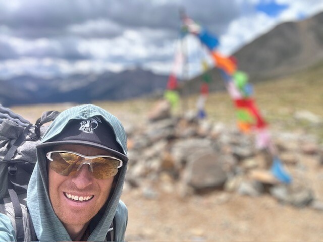
I slept for 9p to 3a in that privy. And it was such a peaceful night without the background fear of rain. I started in the cover of darkness up the trail toward the remote 14er San Luis catching a beautiful sunrise at the saddle. I ditched my stove at CO-114 so I ate some cold oats halfway down to San Luis Pass. The La Garitas have a unique remoteness to them that I don't think you can find anywhere else in Colorado. I rolled through high mountain passes and wound along ridges lost in my thoughts. But then I came crashing back to earth when I began the long Snow Mesa walk toward Spring Creek Pass. Not sure if it was it was the cumulative lack of sleep, food or general fatigue but I could barely gather the energy to traverse this mostly flat featureless surface. I took a dirt nap and it did nothing for me. Eventually I limped my way down to Spring Creek Pass and another of my caches. Then the skies opened up with a fury. I took shelter beneath a pine tree and managed to sleep again. This time it perked me up. I departed Spring Creek in the rain making the slow climb toward Jarosa Mesa. Soon the skies cleared and a light fog began to materialize. I hadn't seen anyone for awhile when a runner in shorts and a tee suddenly emerged. Something clicked in the back of my head - "Jeff!". Jeff Browning briefly stopped for a chat before continuing on in the opposite direction in his own FKT pursuit. I continued on in the golden hour light above treeline toward the CT High Point. Somehow I thought I'd get it before sundown but the many false summits interrupted by ridge walks did not lend itself to this. I finally reached the top around 930p then started down the backside of Coney Peak. When I realized I was not going to make it down to treeline, I took a short detour toward an old roofless mining cabin and crashed within its protective walls.
Day 10: CT Highpoint to Cascade Creek, Segments 22-25
At close to 13000 feet, the night prior was one of my colder, more uncomfortable nights of sleep. But it never rained so there was that. I overslept not starting my day until a little after 7. Descending from Coney and surveying my surroundings it was apparent I was out of the La Garitas and entering the real San Juans. The peaks just feel more imposing with complex cliffs and sharper profiles. I snaked my way over to Stony Pass under a cloudless sky before entering the Weminuche Wilderness. The clouds started building with thunder exploding on the surrounding ridges as I proceeded toward the quartzite Grenadiers. I approached Hunchback Pass fully expecting the storms to close in on me but it never happened. I descended into Elk Creek canyon where my dry luck ran out and it poured with a vengeance on and off for the entirety of my descent through the canyon. The trail turned into a series of lakes and streams. Climbing out from the Animas up to Molas Pass was tortuous; death by a thousand switchbacks. I finally made it to my last cache at the top of the pass at nearly 8p. I started the last 72 miles that night on flat, fast trails fooling myself into thinking these final miles would somehow be easy. There was some light rain around 11p but it subsided and I made it just past Cascade Creek where I decided to setup camp beneath some large pines at 3a.
Day 11 (August 21): Cascade Creek to Junction Creek Trailhead, Segments 25-28
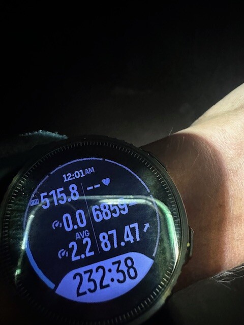
Just before my phone alarm sounded, the skies opened up at 5a. The trees proved as useful for shelter as a burned down house. This was the hardest night rain I had yet to experience on my journey. There would be no folding over my groundsheet for protection. Instead my sleeping bag, my clothes, my shoes - everything became completely saturated and at least 25% heavier. It was like the universe was conspiring against my finishing this thing. I tossed everything in my pack soaking wet and disorganized and just started moving. As light befell the day the rainfall slowed. I stopped and shook everything out. My sleeping bag looked like a dog shaking off as the moisture ejected from it. Forward. There was no other option with 50+ miles to go. I couldn't stop now and I definitely could not spend another night out. I started incorporating downhill running into my hiking and the Blackhawk Mountain area actually went by quickly until the start of the long climb up to Indian Trail Ridge. I bonked hard. I was becoming delirious. Time felt distorted. I kept experiencing deja vu. And auditory hallucinations like the sound of people partying kept occurring. And my equilibrium was off. Napping did little. I ate and drank more then finished the traverse of Indian Trail Ridge and dropped down to Taylor Lake. One last segment and 20 miles to go. But they were no gimme. The descent from Kennebec Pass was smooth but the Junction Creek canyon bottom was not. I cursed the shifty river rocks with almost every step. My inreach finally died at the start of the climb out of the canyon and I asked a camper named Blaze if I could charge it with her battery bank (I left mine at Molas Pass to save weight). She found the trail name "Charger" rather amusing at that moment. I got 1% on the inreach and started the 2000 foot climb at dusk reaching the highpoint 1.5 hours later in the dark. The only thing that could make this finish more challenging would be rain. And sure enough it started pouring until I hit the river below Gudy's Rest. The final couple miles out were a slog. I wanted to be done. I needed to be done. My emotions completely released during that walk. I reached the trail terminus at Junction Creek at 12:01 am with my wife and cousin were there to greet me. I took a quick photo in front of the sign as it started to rain again. What an adventure. The sort I'll always think back on nostalgically yet have no desire to ever do again.