La Grande Boucle des Hauts Sommets (Unsupported)
J’ai débuté au stationnement du Mont Ouareau à 7H11 le matin. J’avais 2 flask avec des filtre XA de Salomon, ce qui m’a permis de prendre de l’eau dans des ruisseaux tout le long du parcours. J’avais rempli ma poche de 2L de Tailwind pour mes électrolytes, des barres Naak, des Fruit2, des jujubes avec des canneberges, du riz dans un sac ziplock, ma lampe frontale dans l’éventualité de finir à la noirceur, et mon cellulaire avec LiveTrack au cas où (je suis seul il faut un minimum de sécurité).
KM 0 à 18
Section sauvage, beaucoup de framboise j’étais en short alors mes jambes ont soufferts. Au Km 8 j’ai pris le mauvais embranchement j’ai dû revenir sur mes pas pour prendre le bon, même chose au Km 9 a ce moment j’ai remarqué que ma montre le GPS étais décaler de quelque mètre. J’ai regardé mon tracer on dirait je cours à quelque mètre du sentier, sans être directement dans le sentier. J’ai rempli mes 2 flask 1 fois chaque dans cette section.
Km 18 à 34
Monter le mont Sourire super bien dégager, par la suite en haut en route pour le Mont Garceau ensuite Pimbina les pieds dans la flotte sans couvert forestier. Juste avant la descente du Mont Pimbina remplis de nouveau mes flask tout en me versant de l’eau sur la tête pour me rafraichir.
Km 34 à 39
De l’asphalte, j’ai couru sur le bord de la route à l’ombre.
Km 39 à 47
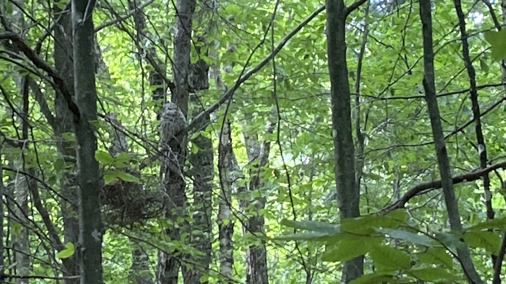
Au Cap de la Fée j’ai rempli mes flask de nouveau et me suis asperger plusieurs fois avec de l’eau pour me rafraichir puisque je suivais le ruisseau. J’ai croisé un Hibou dans le sentier – WOW en plein jour c’est le seul moment où j’ai arrêté pour prendre une photo. Rendu au petit pont de la rivière saint-michel j’ai pris quelque minute pour bien m’hydrater et me rafraichir avec l’eau de la rivière.
Km 47 à 65
Montée de la Montagne Noire, le long du trajet il y a plusieurs petits ruisseaux ou j’ai rempli mes flask et m’asperger d’eau pour me rafraichir. Rendu au Lac Lézard il y a un banc je me suis assis quelque minute pour manger et me masser les jambes. Dans la descente de la Montagne Noire on voit toujours les ravages de la tempête du 21 mai.
Km 65 à la Fin
La nutrition était moins facile, plus de difficulté a manger donc j’ai ralenti beaucoup. Autour du Km 72 lorsque j’ai glissé dans la boue j’en ai profité pour sortir ma lampe frontale. Je suis arrivée à la fin 13H20Min plus tard.
Ma nutrition a super bien été avec le Tailwind et j’ai alterner entre les Fruits2, Naak, jujubes canneberges séché, et le riz (ma blonde avait raison ça passe bien et donne plein d’énergie). Avec mes filtre XA j’ai plus rester hydrater tout le long.
La Grande Boucle des Hauts Sommets (Unsupported)
I started at the Mont Ouareau parking lot at 7:11 in the morning. I had 2 flasks with Salomon XA filters, which allowed me to take water from streams all along the route. I had filled my pack with 2L of Tailwind for my electrolytes, Naak bars, Fruit2, gummies with cranberries, rice in a ziplock bag, my headlamp in case I had to finish in the dark, and my cell phone with LiveTrack just in case (I'm alone, you need a minimum of security).
KM 0 to 18
Wild section, lots of raspberry I was in shorts so my legs suffered. At Km 8 I took the wrong turn I had to come back on my steps to take the right one, same thing at Km 9 at this time I noticed that my GPS watch was off by a few meters. I looked at my track it looks like I am running a few meters from the trail, without being directly in it. I filled my 2 flasks once each in this section.
Km 18 to 34
Climb Mont Sourire really nice, then up on the way to Mont Garceau then Pimbina with my feet in the water without forest cover. Just before the descent of Mount Pimbina filled my flask again while pouring water on my head to refresh me.
Km 34 to 39
Asphalt, I ran on the side of the road in the shade.
Km 39 to 47
At Cap de la Fée I filled my flask again and sprayed myself several times with water to refresh myself since I was following the stream. I passed an Owl on the trail – WOW in broad daylight it’s the only time I stopped to take a picture. When I got to the small bridge over the Saint-Michel river, I took a few minutes to hydrate myself and refresh myself with the water from the river.
Km 47 to 65
Ascent of the Montagne Noire, along the way there are several small streams where I filled my flask and sprayed myself with water to refresh myself. Once at Lac Lézard there is a bench I sat down for a few minutes to eat and massage my legs. In the descent of the Montagne Noire you can still see the ravages of the storm of May 21st.
Km 65 at the end
Nutrition was less easy, more difficult to eat so I slowed down a lot. Around Km 72 when I slipped in the mud I took the opportunity to take out my headlamp. I arrived at the end 13H20Min later.
My nutrition went really well with the Tailwind and I alternated between Fruits2, Naak, dried cranberries gummies, and rice (my girlfriend was right, it goes down well and gives a lot of energy). With my XA filters I stayed hydrated all the way.