


Around the Mountain FKT Run-Hike Report
Charlotte Clews
Supported by Jerome Lawther
5/28/2023
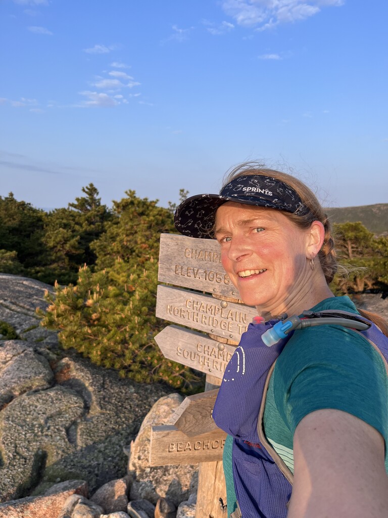
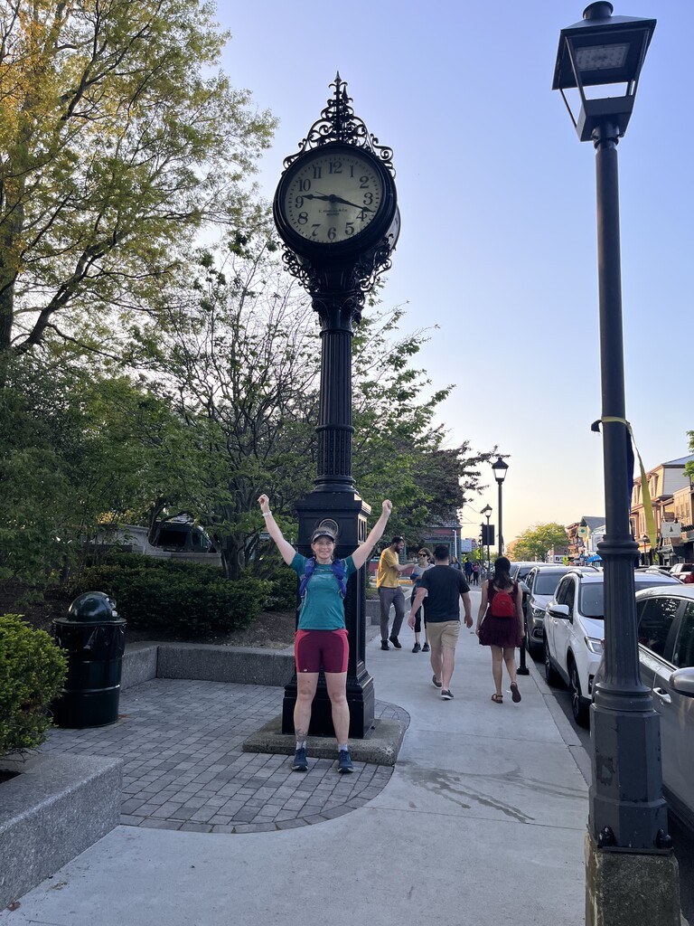
I had planned on a 4:30am start, but last minute decided we needed to water the seedlings because it was already 50º and gearing up to be a hot day. Thus, we got to the Bar Harbor green at 4:35am and made a final pit-stop at the conveniently located public bathroom (open 24-7). I officially tagged the clock tower and started running at 4:45am, just as a town sanitation worker was emptying the adjacent trash can. It was a totally gorgeous morning, and I could see the sunrise through the trees as I headed down the Schooner Head Trail; the song birds were in full swing and there was a pleasant offshore breeze. Just three miles in, Jerome met me on the Park Loop Road to give me my running backpack (ahh, the luxury of support). I headed up Champlain on the Orange and Black trail, which I’ve never been on before, and was greeted by the exuberant song of an Indigo Bunting and an insistent Eastern wood-pewee. The east face of Champlain Mountain was bathed by golden sunrise and I was filled with that particular early-morning-run feeling that All is right with the world. I passed the summit of Champlain and headed down the south ridge trail looking out toward the open ocean, around the Bowl, and over the newly built boardwalk where I encountered my first fellow-hiker of the day. There were several more people making their way down the backside of the Beehive, presumably having hiked up the ladder trail to watch the sunrise from the summit. After tagging the Beehive summit I headed down and across to Gorham Mountain which has one of the most stunning views, looking nearly straight down on to the open ocean and across to Sand Beach. Notably, even though this was the last legal Sunday of the season for lobstering, there was not a single boat in sight.
Jerome met me halfway down Gorham, having run the route in the opposite direction from the Fabbri parking lot. He continued this pattern throughout the day and accumulated 15 miles and 3,000’ of gain for his efforts! We ran to Fabbri, made use of the bathroom and water fountain and I had my breakfast – a thermos of oatmeal, which really hit the spot. Then I was off, running a short stint on the Park Loop Road around Otter Cove – a beautiful spot filled with tons of cultural history (too much to go into depth here, but here’s a quick smattering: https://giftmdi.com/blog/exploring-otter-creek). From there I banked south onto the Quarry Trail which I have never been on! How is that possible? It’s a gorgeous trail built on top of an incredibly well-constructed historical road that leads from the Village of Otter Creek to the shore of Otter Cove. The route then veers through the campground proper, which was full of bleary-eyed campers just crawling out of their tents. Somewhere in the middle of the campground I missed a turn and had to double-back. Lots of bathrooms and water available here too. Then a sharp left out of the woods and onto the blacktop of route 3. I only ever run this section when I’m running the MDI Marathon, and it was fun to reminisce about all the times I’ve danced with the MDI XC team kids who volunteer at the aid station here. Despite the fond memories, I’m glad this section of running on cambered pavement was short-lived! I veered left onto Cooksey Drive, and then left again onto the Hunter Beach trail, another one I’ve never been on.
Part of what made following this pre-determined route so fun was getting to know a bunch of new trails. I love the fact that even though Acadia National Park is so small and even though I grew up in the area, and have worked several seasons as a Park Ranger here and I still run in the Park year-round, there is still so much I haven’t seen. Which brings me to Hunters Cliff Trail – a pretty, though not super-well marked section of trail, where once again Jerome found me. We ran back up to the Day Mountain Parking lot where he’d parked the car, and I re-filled with water and snacks before heading up Day Mountain. Again, I’ve never taken the trail from that trailhead, and it was a pretty one. I ran into my first large group of hikers at the summit marker. Looking around for the trail down, I asked the group if they knew where it was and they shrugged, pointing in the direction I’d come from. I wandered around for a bit, genuinely confused until I finally got brave enough to step amongst them and their coffee cups and saw that they were sitting right in the middle of the trail enjoying their breakfast. Ah hah. As I apologetically picked my way through and around the merry-breakfasters, I caught my braid on branch and got so stuck that one of them had to untangle me.
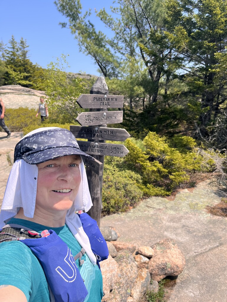
Onward down Day Mountain and up the Triad. Which is a leafy, sometimes hard to follow trail that I often find myself on when there’s still snow on the ground. Hence, I call this area the Triad Triangle, and can’t be alone in how many times I’ve gotten mixed-up on the trails around the Triad. But today I nailed it – phew! And amazingly, Jerome found me right smack in the middle of the Triad-Triangle. We ran down to Jordan Pond, dodging the growing holiday weekend throng (leave your dryer sheets at home people!). I refilled with water from the water fountain, sympathized with the couple that had locked their keys in their car, and the park ranger trying to help them, and then headed back out. Surprisingly, there was nobody else on the Asticou Trail, and I enjoyed the peaceful, shady run down to the Amphitheater Trail. I’ve never been on the lower section of this trail, and probably for good reason. It meanders back and forth across a small creek and was a little hard to follow. It was slow going on this section because rocky-rooty terrain is particularly hard for me due to issues with my vision and visual processing. Finally, I crossed over to the familiar Sargent South Ridge Trail, which is a really lovely trail with good views and plenty of shade. I tagged the summit of Cedar Swamp but for the sake of time, did not pay my respects to the nearby plane wreck. Jerome met me half way down the ridge and we happily ran the soft piney trail down to the carriage road and Brown Mountain Gate House where he was parked. More water and snacks and I sent him on a mission for cold ice tea while I headed over to Lower Hadlock Pond and up Norumbega Mountain. I’d been on the move for six hours at this point and I still felt really good and as long as the terrain was somewhat smooth, my running and hiking felt fast and efficient. But now, at 11:45am, the temperature was climbing. Jerome said the car thermometer read 83º on his way back from Northeast Harbor (ice tea attained), and I’m guessing it hit 88º by mid afternoon. I slowed my climb up the south ridge of Norumbega to keep my internal temp from rising, and to make sure I could still digest, knowing the biggest part of the day was still to come. I had just started down the ridiculously steep Goat Trail when Jerome met me – drenched in sweat having just climbed up as fast as he could in an attempt to beat me to the summit – he was so close! Going down the Goat Trail my legs started to feel wobbly for the first time. We found his car parked on Route 3 at the bottom of the trail and I gulped down my cold ice tea, soaked my bandana in water and crossed over to head up Bald Mountain. More rooty-rocky trail, and I took the slow-down as an opportunity to eat, knowing I would need the calories for what lay ahead. The climb up Bald Mountain and over to Parkman Mountain is pretty, but the descent from there is brutal – a steep drop, into a muddy ravine with way too many obscure trail intersections which led to some navigational confusion. After I climbed my way out and up to Gilmore peak I followed a group of highly-visible tourists the wrong-way (of course), and made a u-turn back uphill toward Sargent Mountain. There were several cold streams to dunk my bandana in, which helped as I headed up the side of Sargent with the full-blast of sun on my back and reflecting off the granite onto my face.
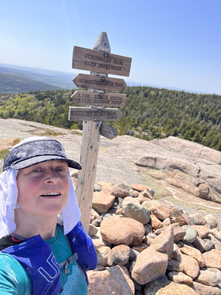
Sargent peak was mobbed as it usually is on a sunny summer day. I caught up to a group of about 20 college-age kids on their way down to Sargent Pond, where they all promptly parked themselves and started stripping down to swim. I stopped just long enough to re-soak my bandana in the pond, squeezing between several bodies to access the water. At this point I was sweaty and dirty enough to be standing out amongst the more well-groomed day hikers and I was getting way more side-eye than offers to take my summit photo. I tagged the summit of Penobscot Mountain and headed down the Jordan Cliffs Trail, where to my surprise, Jerome was on his way up to meet me. He hiked with me all the way down to Jordan Pond (so many people!), up the Bubble Divide Trail which is a steep climb up a boulder field that really is the equivalent of climbing a viewless mountain, and through Bubble Mountain parking lot. This parking lot is always mayhem in the summer and often has at least one Park Ranger and one local cop trying to keep people from spending all day driving in a slow tight circle waiting for a parking spot to open up, and thus their one big chance to be the person who finally pushes Bubble Rock off its lofty perch.
In contrast, heading up the steep east face of Pemetic was peacefully calm with no other hikers in site. At the split in the trail, I always take the steep face, maybe it’s wrong but I’ve never gone into the ravine, it looks like perfect troll habitat and I’m not one to tempt fate. There was one other couple at the summit of Pemetic, and they were full of helpful advice like “Careful, it’s really windy up here!” and “There’s a great view point just over there!”. I might sound snarky, and it’s true that sometimes I have a hard time being super-friendly when I’m offered unsolicited trail advice for the umpteenth time in a day, but I do actually love that people feel a sense of belonging here and want to share that feeling with others. Happily for him, Pemetic was Jerome’s last climb of the day and we headed down the North Ridge together, reminiscing about our disastrous climb up this trail just a couple months ago when we found ourselves post-holing through thigh deep snow because “someone” didn’t want to “just run on the boring carriage road back to the car”. My hyper-extended knee is still recovering from that debacle.
Jerome’s car was parked in the Bubble Pond parking lot and I refilled with water and snacks for my final time before heading up the West Face Trail. I had been anticipating the steepness of this trail all day with some amount of anxiety, but I crushed it! I thought it would take me an hour to get to the summit of Cadillac but it only took 40 minutes and I was still feeling good. I think this success is a testament to all the calf work and lunges I’ve been doing lately to rehab my thru-hiking injuries.
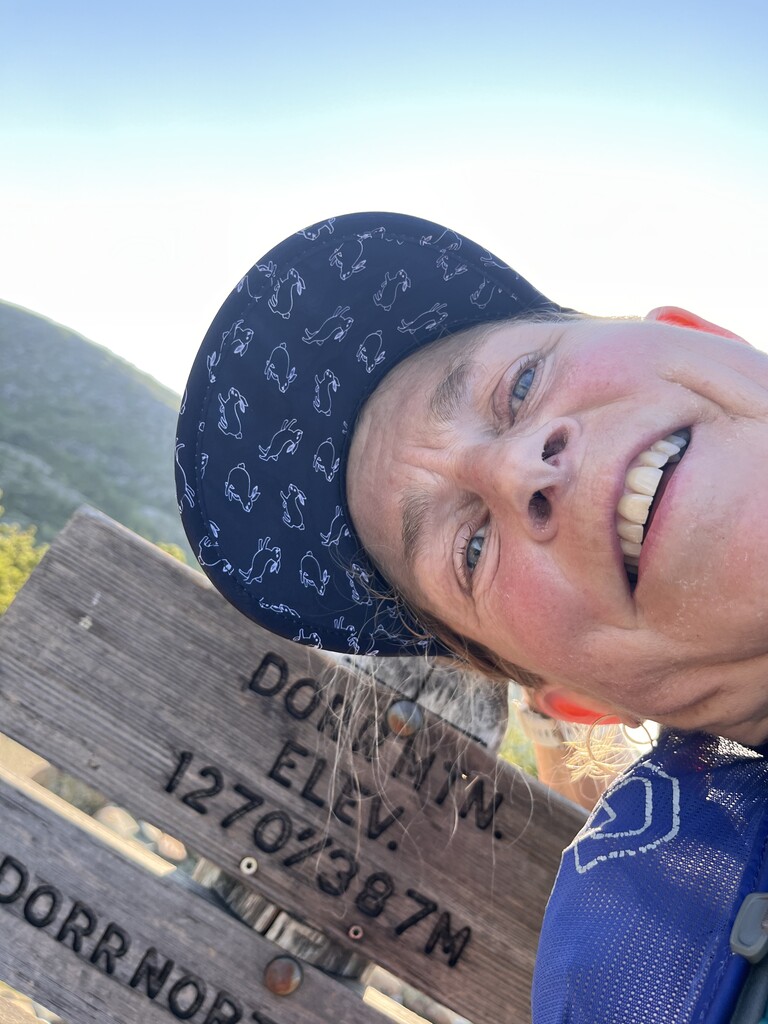
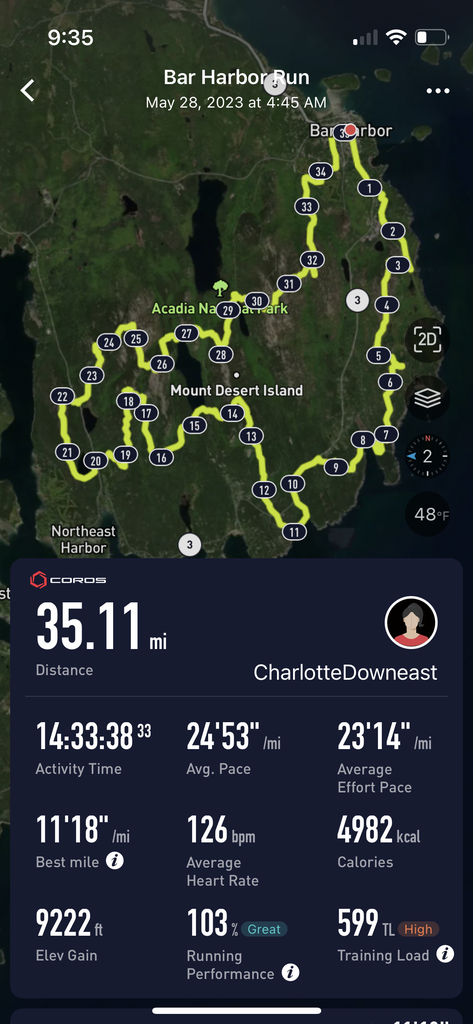
Cadillac summit was packed with its full allotment of cars and people. I love how many different languages are spoken up here during tourist season. As I crossed the summit I only heard one English-speaking family amongst a sea of Mandarin, Cantonese, Hindi, Spanish, French and plenty more I couldn’t recognize. I headed down the trail toward the gorge, passing by a couple of dudes smoking-up who noted my ability to “run a lot faster than they ever could”. And then up the last steep trail of the day to the summit of Dorr. I turned around and started down the north ridge trail, running into the glowing afternoon light and feeling deeply satisfied as I gazed down at the little village of Bar Harbor below. That was before I was reminded of how long the trail up and over Kebo Mountain is. Yes, it’s a pretty trail, dappled by sunlight filtering through the fragrant pitch pine, but it’s also interminable. And the summit is not where you think it is, oh no, it’s further on, up another little rise, and then another. And then finally, I reached the last summit of the day. I headed down the short, steep trail to cross the Park Loop Road, and then ran the Kebo Trail past my old house and the golf course where I lived when my first baby was a baby and we spent many hours walking together up and down the golf course at sunset crying and not falling asleep. Even after 14 hours, 34 miles and 9,000 feet of climbing my legs were feeling good and I ran all the way into town, a little slower because of the hyper-extended knee, but otherwise comfortable and happy. I turned onto Mt. Desert Street which was filled with tourists dressed up and searching for food and I hit the clock tower with Jerome cheering me on. Several families watched from nearby, simultaneously bewildered and disinterested. I love the way ultrarunning adventures are so deeply personal in that way.
No amount of writing can convey all the moments of joy, drama or satisfaction that I feel throughout a day like this. The goofy looking wild turkey who stuck her head out from behind a tree, the tourist dressed head-to-toe in day glo orange spandex on gray granite summit, the puffs of yellow pine pollen blowing off the trees as I brush them, the beautifully crafted stonework (by humans and glaciers), the white tail deer pausing mid-chew to stare at me with a leaf sticking out of her mouth, the smell of sun on granite, huckleberry flowers, mountain cherry, and rhodora. My best response to the question “Why?” is that days like this fill me with the gift of so many memories and for at least a brief moment, I am reminded that at my essence, I am capable, healthy, strong. That is all.
Huge thanks to Jerome who absolutely nailed the logistical support and made the whole day a lot of fun. I am beyond lucky and filled with gratitude that I have partner that thinks this kind of thing is as fun as I do.
Thanks to Jeremy Dougherty and friends who conceived of this beautifully choreographed route and inspired me to get out and see new parts of the island. If you have to pick one 50k to run around Acadia, I highly recommend this one.