We were the first people to complete the Northern + Long Range Traverse in two years, as the route was closed due to the Covid-19 pandemic. For this route you need to obtain a permit from Parks Canada and complete a safety briefing. Typically, they do not issue permits in early-June due to snow cover in the mountains and the annual June bird breeding season (the traverses usually open in late June). Due to low snow cover this year, Parks Canada made an exception and released our permit.
We set out with the goal to run the traverse in a day, but came prepared to spend 1-2 nights in the backcountry if necessary (we packed a tarp, bivvies, Merino thermals, lightweight rain gear, medical kit and around 5000-6000 calories of nutrition each in the form of Tailwind, gels, bars, pita wraps). I used a 15L running backpack that wasn't quite full, and John used a 12L running vest. We used poles, and I used filter caps on softflask bottles for water filtration. For navigation we used GPS tracks on our running watches (John had a Garmin Fenix 5 and I used my Suunto Baro 9). John had a full sized Garmin Inreach with waypoints and a GPS track loaded for safety and navigation purposes, and I had a Garmin Inreach Mini for safety purposes (+ GPS track loaded in maps.me app on my phone). We also carried a waterproof topo map of the route with waypoints pencilled in and a compass in the event our GPS navigation devices failed.
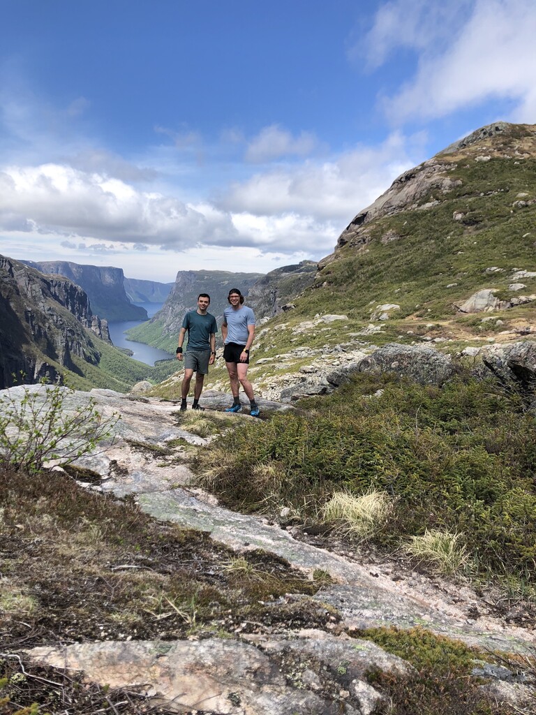
The start of the route was a relaxed gravel path for about 2 km until we hit the snug harbour trail mud fest. We encountered high water level at Western Brook around 3-4 km into the run. The river was about 15-20m in width and water level was up to our thighs-waist. Crossing with poles was manageable, but would be difficult without. The remaining trail to snug harbour was extremely muddy and wet, and the morning was quite foggy. From snug harbour we climbed onto the northern rim of the western brook pond fjord, where the fog broke and the views were expansive. The climb was marked with flagging tape in the trees, and there are old boards that have rotted away with rusty nails protruding out. Upon gaining the fjord rim, there is no trail for the next ~50 km until reaching the base of Gros Morne mountain. The next several km were through the 'tuckamore tangle', where we needed to find the most optimal leads through the dense tuckamore trees, but it is inevitable to travel through the brush at times and our legs were constantly scratched and cut. The northern traverse reaches from the end of Snug Harbour trail to the tip of the western brook pond (WBP) gorge, where the long range traverse then begins until its confluence at the base of Gros Morne mountain. Navigating the first half of the northern traverse was manageable as we hit natural leads through the tuckamore and followed gullies to split hills, however, we stayed high along triangle pond where we should have skirted the ponds shore for easier travel. It was rough going around triangle pond through our travelled route. During the second half of the northern traverse there was more climbing than expected, and we were longer than expected in reaching Gillie's pond. There was a significant climb where we took a direct, more technical route which was also more fun to travel over. We saw a caribou along this point, which was the only large wildlife we encountered during the run. He was curious about us, but kept his distance when we got close. After we finally reached Gillie's pond, getting out was difficult due to tuckamore and uneven dense terrain. After finally breaking the terrain we were able to follow a decent game trail up a gully and between two hills to the outskirts of the large cliffs of WBP gorge. Upon reaching the WBP gorge we had a phenomenal expansive view of the fjord, where we stopped to re-group for food and photo taking. It should be noted that there is ample opportunity for retrieving water along the route, but it is wise to fill up at snug harbour before embarking on the northern traverse, as there is a large gap in water sources in between leaving snug harbour and arriving at triangle pond. Additionally, the northern traverse is more difficult terrain than the long range traverse due to tuckamore cover and less game paths to follow. We were around 30km to the WBP gorge.
After leaving WBP gorge there was 3-4 km of solid running on game trails to reach little island pond and continue travelling to marks pond. At marks pond we forded a small river to travel on the left side of the pond, while the traditional hiking route goes around the right side where the camping platforms are located. We opted to take the shorter route, as Steve Wheeler also did during his FKT in 2015. During this time, one of John's poles unfortunately broke, leaving him with one pole for the next 20-25 km. From Mark's pond we travelled towards Hardings Pond via a middle waypoint known as the boulder. We traversed down to the wardens cabin at Harding's pond, but it is likely possible to save significant time if you travel straight through the country, wide around Harding's pond, towards 'the notch', cutting to the right of two other ponds instead of dipping down towards Harding's pond. The notch is the next navigation waypoint after Harding's pond, and is notoriously the most common navigation blunder during the traverse. Coming out of Harding's pond was a reasonable climb into the hills and then we dipped down into the notch, which cuts a narrow rock bridge between two ponds. When I hiked the traverse in 2014 we got lost here for several hours, ran out of water and then arrived to find a beaver dam upstream of the water travelling from pond to pond. The travel between Harding's pond and Green Island pond was difficult and long, over very saturated terrain. While travelling over this area we both fell several times, and my shoes were almost sucked off my feet from the mud. During this stretch we received our first view of Gros Morne mountain which was quite rewarding, but it was still very far off into the distance. Green Island Pond is likely the nicest campsite along the route, and I remember spending a fantastic evening here in 2014. The second most difficult river crossing of the traverse was upon leaving Green Island pond. It was a very wide crossing, however, with lots of rocks to traverse along. After leaving the pond we gained elevation via a solid game trail onto the last plateau, and moved along small dips and rises until we eventually reached Bakeapple pond with phenomenal views of Gros Morne and ten mile pond. After leaving Bakeapple pond we eventually split two ponds and then reached a small pond at ferry gulch. At this small pond you stick to the left shore and then keep low to hit the new ferry gulch exit, which is easier than the old ferry gulch exit. We accidentally stayed high through this terrain which brought us to the slightly treacherous old ferry gulch exit. It is not so bad descending through this exit wearing running vests, but I remember it being difficult in a 60L hiking pack in 2014. We encountered some mossy rocks and ice on the descent here, which made the going more tough. After exiting down ferry gulch we gained the Gros Morne mountain trail for approximately 7 km to the parking lot. After 3 km of scree running on this trail we reached the newly created 4km valley trail, which is undulating, wide and quite runnable. We ran these last 4 km at a ~5:30 pace for a strong finish.
Overall the day was absolutely fantastic. John and I worked well together as a team in navigating and keeping motivation high, and it was helpful in switching the lead between us. We found whoever was in the lead would push the pace which would help carry the follower along at a higher pace than they may have travelled solo, additionally it was nice to have the mental break in not having to navigate while following. There are definitely some route optimizations that could be taken on the route (mentioned above), and we hope others will come attempt it. Thanks to Steve Wheeler for putting this route on the map. It was a great adventure