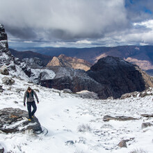
The Cape Fold Belt is a series of ridge lines of sandstone rock that hugs the southern tip of Africa. They once were the foothills to the Falklands plateau what stood higher than Everest before continental drift. The range gets its name from the unique way the rock has been bent like clay in places from the force of continents pushing up agains each other. This is also home to the Cape Floristic region which is the most biodiverse place in the world, holding 20% of Africa’s flora in 0.5% of Africa’s land mass. This was my inspiration to traverse the land on foot - to visibly witness the landscape change before my eyes as I move across it.
This is a gate-to-gate run. Starting at the Pakhuys Pass gate in the Cederberg, and ending at the Groendal Reserve gate near Uitenhage, 1136km east, with approximately 46 000m to cover. Very large portions of this line are off trail and self navigated, with the objective being to follow the purest line across the top of the ridgelines. It can be quite technical in sections, but at no point did I need ropes.
I started on 1 September on recommendation. This may have been too early as I hit bad storms in the Cederberg that threatened hypothermia, and snow in the Hex. That said, by the time I hit the Outeniquas temperatures were going into the 30’Cs, so any timeframe would have had its challenges.
I ran the entire route solo with the exception of the start which my friend Armand du Plessis joined for, and then a photographers, Simon Pocock and Jared Paisley joined me for a couple of days in the Hex and Langeberg. Gerry Noel and Timmy Hampton joined for a couple of hours in the Outeniquas, hung over after a wedding. With 1000km in my legs, it was questionable who was the worst company at that point.
I did the route supported by Marian Penso who managed the trip. We allocated meet up points where roads dissected the mountain range. The general strategy was to meet, travel to nearby accommodation, resupply, sleep, and then return to the same place to start again the next day. On average these were 10-12hrs running apart, with the longest stretch being 48hrs without contact. This was necessary as access is minimal and to carry enough food and supplies to traverse the full range would have been the weight of a standard hiking backpack, forcing slow movement, and running into towns to resupply would have required 2day detours. Self supported just didn’t seem viable.
Water was often scarce or non existent on the ridge lines. At the worse I went 36hrs with only 4L of water with me, in temperatures that went into the mid 30’Cs. Where I ran in valleys, and further east it was better.
Access in some places can be sensitive and a little homework is recommended around this topic. Some areas also have wild animals on them, as I learned when I ran into a heard of buffalo at 22:00 at night. Not ideal, but one of the best experiences of my life.
I was probably a bit undercooked when I started and got tendonitis after a week of running. Physio said this would be fucking sore but it wasn’t going to do any permanent damage and that if I push through it will eventually go away. She was right. It was fucking sore, and with a week to go the pain started to ease.
I spent a year planning for this trip, and it does take an immense amount of prep work. It is not a conventional or groom trail by any means. Expect tricky navigation in sections, slow going through thick bush, wild weather, and long hours with no one in sight. But it is one of the most beautiful and diverse lines you’l ever explore.
Im happy to answer any questions if you are curious to look into projecting this.

