I worked off of Mike Wardian's original route from 2020. When I saw it posted, I had to do it. Though I don't live in the area now, I grew up around DC—this was like a running hug to my hometown.
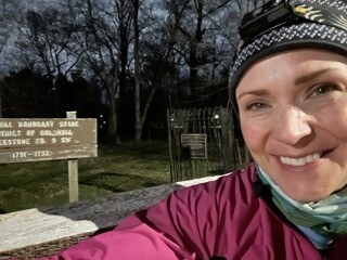
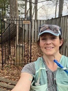
Beginning at SW9 (Benjamin Banneker Park), I worked in a counter-clockwise direction. My journey began at 4:54 am on 3/28/25, and I closed the loop after 14 hours and 25 minutes.
I had to take a Lyft to the start; there were no bathrooms at Benjamin Banneker Park. Also, during the week, you can't park nearby without a permit (restrictions due to the proximity to the East Falls Church Metro).
I ran southeast to SW8, then to Dunkin' to grab a bagel and use the toilet—super nice folks. From Dunkin', I ran to the SW7 at the elementary school before getting to SW6 in the median. More folks were out than I expected, but it wasn't like I had to dart into the street every ten feet, either—lots of folks waiting for buses and walking their dogs.
Once on Route Seven/King Street, most markers are just off the road. I stopped at the Starbucks just after SW4 to get a new bagel (the one from Dunkin' tasted off—bad batch), and I went to the BR again just in case one of the ones I planned on wasn't available.
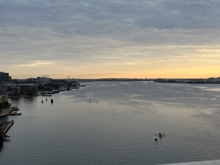
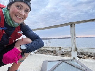
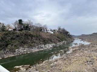
There were a few turns after passing the train station in Alexandria, but the navigation was fairly easy to the Jones Point lighthouse, where the southernmost boundary stone is. There is supposed to be an open bathroom under the Woodrow Wilson Bridge in the Jones Point Park area, but I didn't test it.
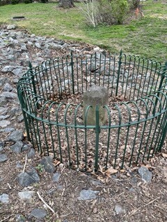
I tagged the South Boundary stone, then crossed the bridge. There was a port-a-potty on the other side of the bridge after coming off the ramp. The hill up out of National Harbor past MGM is a good one! I talked to a gentleman at the top of the hill while waiting for a light. He had done the boundary stones by bike before and shared they had a heck of a time getting to SE9, similar to what others I had contacted about the route had said.
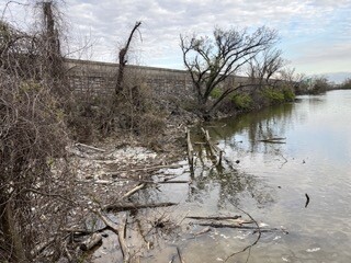
SE9 is tricky. I was running by myself and at the time I approached this stone, it was Friday morning during rush hour. The only real option would be to take the Potomac Heritage Trail (PHT), then break left to follow the water line from Oxon Hill Farm/Oxon Cove Park to go under the 295 bridges and to the boundary stone. After reaching the rock wall that surrounded the walls that supported the freeway, the growth, and seeing the water crossing, I decided to turn back as it wouldn't necessarily be safe nor wise to continue considering my main objective was to complete the loop.
I returned to the PHT, followed it to DC Village Drive, and turned left toward the concrete plant. Upon entering the plant property, I asked permission to cross to the other side to view the stone. The gentleman I spoke with said he could not let me go because I did not have a hard hat, and he didn't want to get in trouble. This was totally understandable but also disappointing. But again, the main objective was the loop.
I ran back to the PHT and went to the Eastover Shopping Center. I would get a bagel and banana and use the bathroom at the Giant. I also tried to find chocolate milk for a new friend outside the supermarket, but the only one I saw looked like it fell off the truck. So I had to give him a Gatorade instead.
I met my dad in the parking lot, changed my shoes, clothes, and vest (I fell in one of the creeks on the way to SE9), got more water, and replenished my fuel. The stop was way longer than I wanted, but it was worth it to be dry.
SE7 sits across the street from the shopping center but was hit by a car last year and is still being repaired. From there, I headed NE along Southern Ave. Lots of friendly folks. One response I got was, "Have a blessed weekend."
SE6, SE5, SE4, SE3, SE2, and SE1 are all on Southern Avenue and fairly easy to spot, though the trek isn't a straight shot. Southern Ave has a gap just after SE4, where you need to navigate around an apartment complex and through the Naylor Road Metro Station. Additionally, before SE1, the road has a kink around the National Captial Hebrew Cemetery, where you need to make a turn to stay on Southern. It bummed me out to see so much litter in this part of the city.
There are no real opportunities to go to the bathroom between SE7 and NE8. But, if in a pinch, three metro stations—Southern Ave, Naylor Rd, and Capitol Heights—have bathrooms (though you usually have to ask the station manager for access). Also, Fort Dupont has a visitor center with a bathroom (between SE2 and SE1), but it is only open during certain times of the year.
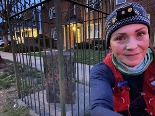
At the end of Southern, I took a short path to the Eastern Stone, then headed northwest along Eastern Ave. NE9 is on the right side of the road along the fence line of a house.
For NE8, I continued along Eastern until it stopped at the intersection of Kenilworth Ave. I crossed Kenilworth and stayed to the right of the fence of the retirement home until I got to the end of the property (it's like a right of way that utilities would have used but has filled in). A path becomes visible and takes you to another fence further to the right. Along this fence line, you find NE8.
From NE8, you need to make your way to the Kenilworth Gardens and the Anacostia Riverwalk Trail. You can bushwhack behind the retirement home and apartment complexes (at some point, there was a trail, but it wasn't obvious when I was there), or you can go back to Kenilworth Ave and take side roads to the gardens. I took the side roads after encountering a marsh area.
Kenilworth Gardens is a free National Park with bathrooms if you arrive during operating hours. If you arrive during non-operating hours, I believe the gate will be locked, and you will have to find a different way to access the trail.
I met my dad in the parking lot, ate some food, changed my shoes and also my shirt since it had started to get warm. This is about halfway (just over 30 miles) through the route.
The Anacostia Riverwalk Trail is the shortest way to cross the Anacostia River by foot when following the boundary stones. It's a beautiful trail and nicely maintained. I was on it for just under 2.5 miles.
After crossing the footbridge, I made a left on Bladensburg Road. There are several fast food restaurants here if one needs quick access to the bathroom or a snack.
NE7 is well into the Fort Lincoln Cemetery (about 0.8 miles) at the far end of the columbarium. I walked the entire time I was in the cemetery out of reverence. Although I'd add that running there would also be uncomfortable because the hills are very drastic. If I were visiting by car, I would've explored more of the cemetery. I'll probably come back.
After leaving the cemetery, I headed NW on Eastern Ave, finding NE6 within the fencing of a house on the right. I got to NE5 a mile later, then cut across the road to connect with Eastern, which changes names before I needed to turn right and then left to get back on Eastern (classic Northeast road navigation!) Following the left to get back on Eastern is NE4 on the right side of the street.
On the way to NE3 is a Giant Food, which would be a great place to restock if doing the run unsupported. A little further down is NE2 on the right at the back corner of a McDonald's parking lot.
From NE3, you take Eastern until it T's and make a left on Carroll Ave, then an immediate right onto Maple, where NE2 is on the left. This is a great area to get a sandwich from one of the restaurants or a drink from Starbucks. I met my dad at Starbucks, got a Dragonfruit Lemonade (which totally hit the spot!), used the bathroom, filled my water, got more gels, and then headed NW to NE1. NE2 is at close to 41 miles into the route.
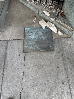
NE1 has a plaque instead of a stone. It sits in front of an entrance to a restaurant. From there, it's a lot of downhill to the northern stone (it's on the left side of the road—East-West HWY is a busier road with the sidewalk on the opposite side of the stone).
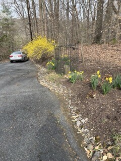
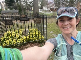
You have to go through Rock Creek Park to get to NW9. It isn't terrible to navigate the park, but having GPS or a map will be helpful. Before leaving Rock Creek Park, a port-a-potty was in the parking lot. NW9 is off of a shared driveway (and was super cute with daffodils all around). From there, it's SW on Western Ave.
NW8 and NW7 are in private yards. You can see both stones from the road, but if you want a picture next to the stone, you should knock on the door to ask for permission.
After NW7 is a shopping center with several places to find a bathroom (Friendship Heights). NW 6 is in a little park strip on the right after passing the shopping areas.
NW5 is on the property of the Dalecarlia Reservoir. I tried to contact the Army Corps of Engineers about whether there are ever opportunities to access the stone but didn't hear back. Maybe they'll have special showings at some point. Either way, I couldn't add it to my list of boundary stones visited. I continued to Little Falls Stream Valley Park, where I hooked up with the Capital Crescent Trail, which takes you by NW4, though it is forty yards behind the reservoir fence.
I had read the map wrong and thought the Capital Crescent Trail crossed Macarthur Blvd and suggested meeting my father at the nearby Exxon to refuel and go to the bathroom, but in reality, the trail goes under the Blvd, with steep inclines on both sides, making it impossible to climb. I didn't want to backtrack, so I met him further down the trail after the reservoir. At this point, I was at 50 miles.
Off of the Capital Crescent Trail is a connecting trail (very rugged in comparison) down to Clara Barton Hwy, over the C and O Canal, and across the Chain Bridge. On some maps, it looks like you can't go straight past the parking lot on the other side of the bridge, but you can, and it's the safest by far. You connect with Old Glebe Rd and take it to the end before navigating North Arlington and Falls Church neighborhoods to get to the remaining stones.
At NW3, you need permission to access it as the stone is in the owner's backyard. NW2 is off of Old Dominion, a busy road with no shoulders. It looks like you can climb the hill in pictures, but you can't (I learned this the hard way). You can see the stone fencing when looking at it from the driveway across the street (when there isn't growth—it might be different by May), or you can get permission to go in the backyard. NW1 is one you need to obtain permission to see, as it is fairly far back on the property. The folks are pretty used to people coming to their houses. The gentleman on N Tazwell said it was why he bought his property.
After NW1, it's just a few turns to Williamsburg, which is mostly downhill. After going under Route 66, you make a left onto N Arizona, and the Western stone is right there (surrounded by daffodils when I visited).
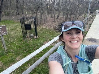
A few more turns and about 1.3 miles later, I was back where I started at Benjamin Banneker Park!
Gear:
I used the Salomon Adv Skin 12 for the first 20 miles, but after I fell and it got soaked, I changed to my Salomon Adv Skin 8 (women's). I had extra clothes and food for the first 20 miles but met up with my Dad every 10 miles after that, so the smaller vest was perfect.
I used a Camelback 1.5 L bladder (water) and a 500 flask (Skratch). I replenished the Skratch at each stop, but the water only at 20 and 40 miles. I probably should have had more water, but then there's the whole bathroom thing.
I started just before 5 am and used a Nitecore headlamp for the first hour and forty minutes. Luckily I didn't need it again in the evening.
I started in Altra Torin 7s, then went to Topo Ultra-Flys at 20 miles, and switched back to the Torin 7s at 30 miles and stayed in them. Love the Ultra-Flys's room, but the Torins had less than 100 miles on them and felt more springy. When I put them on at 30 miles, the moisture from falling in the water wasn't a big deal.
I wore Injinji socks that went over my calves because I knew it would be in the 40s to start and because I was going through the brush at Oxon Hill. I changed to Injini crew socks at 20 miles. My toes were in great shape except for one little blister on my right middle toe.
I used Squirrels Nut Butter in the classic chafing spots and Aquaphor on my lady parts. The only place that chafed was on my back under my sports bra, where I had forgotten to put the butter.
Fuel:
I started with the plan to have a gel (Precision, Marteen, SIS, or GU Roctane) beginning at 3 miles and repeating every 6 (i.e., 3, 9, 15, etc.), and then I would eat real food (bagel, crackers, fig newtons) at 6 mi, 12 mi, 18 mi, etc. I would supplement with little snacks, my Skratch and electrolyte chews.
Instead, after ten miles, I ate real food each time I stopped at a boundary stone and had gels in between as I felt hungry or had a gel and a small bite of bagel.
At the stops with my dad at 20, 30, 40, and 50 miles, I would have a little protein drink (like 1/3 of a Fairlife), a Vitamin Water, and something significant like salted potatoes or orange slices.
I did a really poor job of counting carbs and calories, but this was the first time I didn't feel sick after twenty miles. I usually have to force-feed, so I'm pretty excited to implement the eat-a-little-something-every-mile strategy moving forward.
Overall thoughts:
This run was pretty awesome. The only negatives were SE9 and SE8 and the bathroom situation.
If I lived closer, I would have been able to scope out the bridge situation around SE9 better and figure something out. When I planned my trip for this run, I worked in two run days to play with, Friday and Saturday. Saturday was my primary because there would be less traffic overall, and also so I could enter the concrete plant when it was safe. But when the temps started to solidify at 60s for Friday and 80s for Saturday, and considering most of my training in Massachusetts has been in subfreezing temps over the last three months, 80s was going to be too hot—I had to go Friday.
The bathrooms. It's funny how as you get closer to a city, the number of bathrooms increases exponentially, but the number of available bathrooms decreases.
There are only a few public restroom options, a few gas stations with bathrooms, and the coffee and fast-food places have codes on the bathrooms for public use (if they have any at all). Running on trails...well, there are more options. Doing the same thing in the city will get you arrested.
There is a lot of stop-and-go during this route because of traffic lights and if you plan to take pictures at the stones.
For a fun run, this is a great route. I did it alone because of my circumstances at the time, but it would be a blast to run it with friends, too.