
Last summer I poured a lot of energy into attempting the Georgia Appalachian Trail FKT. I completed the route, but in a time that only (nearly) "tied" the historical supported record, leaving me unsatisfied. What to do next? I couldn't really imagine going back out and trying GA AT all over again anytime soon. I got a late entry into the covid-delayed Fall 2020 Georgia Death Race, and in training for that found myself enjoying many miles on the Benton MacKaye Trail. I remembered seeing other parts of this trail in the Cruel Jewel 50-miler a few years earlier, and after completing GDR, I figured it might be fun to start exploring the other portions of it that I'd not yet seen. Eventually I realized that the total mileage and elevation change across Georgia's BMT appeared almost identical to those of Georgia's AT. As many other athletes went out to attempt GA AT in 2020-21, I thought "why not GA BMT?" I hoped that maybe by doing it, I could inspire others to think similarly...
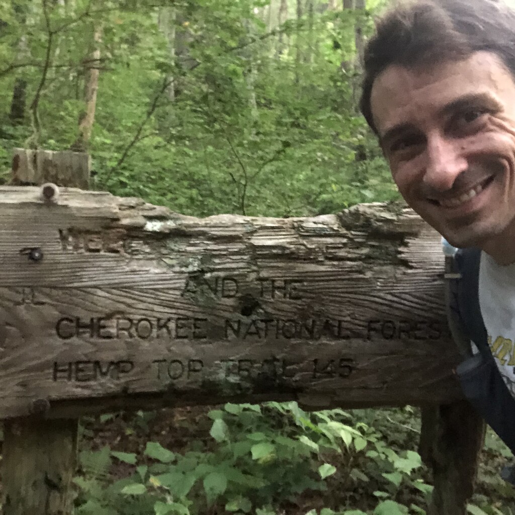
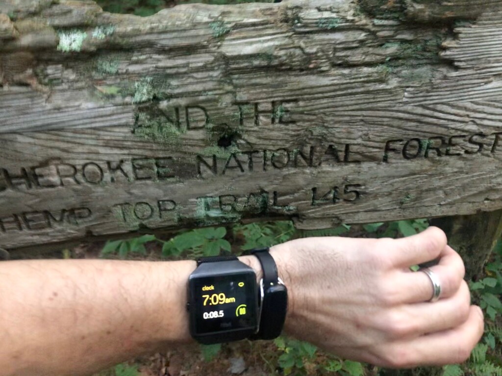
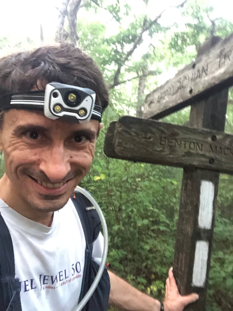
The BMT crosses from GA into TN at Double Spring Gap, several miles from any trailhead (again, similar to the AT's Bly Gap at the NC-GA border). And so once again my wife Maggie and I stayed at a hotel in north GA (Blue Ridge) the night before, then drove before sunrise to the closest possible drop point, Dally Gap. Arriving around 5:30, from there I had a ~5.3-mile hike to the border, along the Hemp Top Trail (which merges with the BMT ~1 mile north of Dally). I ate breakfast but also slow-jogged a little on the flat or downhill sections of this hike-in, eager to get to the start. For the official start point, I figured a good landmark was the "Welcome to Tennessee and the Cherokee National Forest" sign (rendered partly unreadable by...bears, probably?) So I took photos there and started my trackers at 7:09 AM Saturday.
The first ~26 miles, down to Bushyhead Gap--all on single-track and some very old logging roads--were beautiful and felt absolutely great. I saw Maggie once during this portion at Watson Gap (~8.5 miles in) for a quick resupply. South of that the BMT intersects the Pinhoti Trail at its remote northern terminus, a fun landmark for Georgia and Alabama ultra-runners. There is one substantial climb during this segment, up Flat Top Mountain south of Dyer Gap, but it felt fine on fresh legs. Flat Top, and the clearing at Double Hogpen Gap ~1.5 miles farther south, are very neat spots to visit -- they feel so remote today, but had a community living here, albeit a century ago. I'd made a note of where water was available in this section and carried a filter with me all day, but also carried enough fluids with me (~3L most of the day, and nearly 4 on this one section) that I ultimately never needed to filter between crew stops.
After Bushyhead Gap there are 2.6 miles of paved road, where I met Maggie again. I was feeling good, still averaging under 13 minutes/mile, but now the temperature had climbed into the upper 80s and with little cloud (nor tree) cover out on the roads. I stuffed ice in my hat and was grateful to head back into the woods off Boardtown Rd, although the next few miles contain several more intermittent road segments. It's a beautiful area though, featuring creeks and ponds and cabins I'd have loved to stop and stay in. This area also has the BMT's one shelter within Georgia, where most full-BMT adventurers have stopped for the night, rendering the previous speed record on the Georgia section (to my knowledge) a beatable ~30 hours or so.
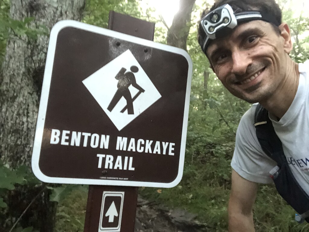
The trail next intersects US-76, a 4-lane highway the crossing of which is an "exciting" moment in any BMT traverse. Just before this I met my first pacer, Hunter Leininger. Hunter is somewhat of a hero of mine, after his FKT set on the full BMT earlier this year, among many other endurance feats. So I was surprised and thrilled when he offered to come out and run with me, a stranger before today. We were honked at but made it safely across the highway amid moderate afternoon traffic, and back onto a mix of roads and trail up to Weaver Creek.
In retrospect, this was a turning point. I'd overestimated how long it would take us to reach Weaver, so my wife wasn't quite there when we arrived. We called her and she was 13 minutes out. In the interest of speed, I decided to forego the sandwich and water refill I'd been wanting here and press onward. Hunter had extra water and I had other food to eat. But if I had paused in the shade here to cool down from our hot road miles, I might have taken out my elevation profile (or I should have studied this more closely beforehand) and noticed we were about to embark on what is actually the biggest sustained climb of the entire route. Instead I plunged into it naively, and quickly felt outmatched. Hunter had brought hiking poles and, noticing my struggle, offered them to me. I've never raced nor really even trained with poles, but I had some in the crew car in case I felt I needed them later in the evening. Hunter gave me some pointers and I definitely started moving faster using his poles, but still had to stop entirely mid-climb once or twice as my left quad seized up. Hunter offered some Tiger Balm for it (he sure came prepared!) which did seem to help at least temporarily.
We made it over the top and down to the Fall Branch Falls trailhead, ultimately spending ~90 minutes on this ~10k section -- slower than my earlier pace but really still OK given the topography, though at the time I felt quite sobered by it and fearful of what it might portend for the many remaining climbs. Here we met Maggie and did some trouble-shooting of gear issues: my soft flasks kept coming apart, my phone wouldn't charge, and my secondary tracker (Fitbit) had somehow already died. We ditched the Fitbit (Garmin would have to suffice), swapped out the soft flasks for plastic water bottles, and left the phone with Maggie to charge. (We quickly realized that my sweat was corroding the charger cables and thereby ruining them; in the future I guess I need to put the whole phone+cable+battery in a ziplock if I want to run with it in conditions like this. Thankfully, Maggie had a third unspoiled cable to use in the car.)
Hunter stayed with me for the next 3.4 miles on roads to Shallowford Bridge, where Maggie was again waiting along with my next pacer, Kat Schuller. Kat is another incredibly generous runner friend whom I also met for the first time when she paced me, in a previous race. She also knows and loves the Georgia BMT more than anyone else I know! And on this day, I may never have finished without her.
I felt pretty overheated at this point, and yet ALL the "easy" (road, or net downhill) sections were now behind me. Thus followed a series of embarrassingly slow segments: the <2 miles from Shallowford to Old Dial Rd took nearly 40 minutes; the ~6 miles from Old Dial to Wilscot Gap took 2 hours. Some part of this was me lingering longer at the crew car between each segment, but it was mostly just slow hiking on these net uphill sections as temperatures remained in the 80s even close to sunset. Kat was fantastic throughout this time, offering salt tabs to try to help my still cramping-quads and now side stitches, helping me find the most efficient rhythm with my poles (and carrying them for me where it was flat enough to run), and generally distracting me from my relentlessly growing misery.
Kat said goodbye at Skeenah Gap, where I took a look at my pace chart for the first time in ~8 hours. The good news was that I had "only" ~25 miles remaining, which felt like surely I had come too far to quit. The bad news was that I'd been averaging close to ~20-minute miles for awhile now. At 15 hours elapsed, it now seemed impossible that I would speed back up enough to come close to matching my GA AT time of ~21.5 hours, and if I slowed further then I could easily exceed 24 hours. I decided to mostly ignore the time and just keep moving as best I could.
Between Skeenah and lower GA-60 was when I first felt truly nauseous, gagging on foods that I eat all the time in training and racing. From then on I ate just a couple energy gels and chews, and a few Oreos, but mostly survived on calories from Tailwind and Coke... though definitely not at a rate sufficient to replenish what I was burning. We had hoped it would cool down in the mountains at night, but I saw temperatures in the 80s even at 4am, and it never dropped below 75. Nonetheless at times I could see my breath condensing due to the equally high dew point. (Read: humidity... although I never got a drop of rain all day!) So every time I would try to push at what would normally be an "easy" pace, my heart rate would redline and I'd be dripping sweat again. These hours worth of sweat running into my socks gave me the worst blisters I've had (and cuts from small rocks stuck in there; I never changed shoes or socks), making every step increasingly painful. I resorted to using my poles to ease the impact on my feet and quads while shuffling downhill, which of course by definition further slowed me down.
I knew it would be quite the spirit quest from GA-60 to the finish, 18 slow miles during which I'd see Maggie only once, at Three Forks (and no one else along the way either). It was cool to cross the Toccoa Swinging Bridge alone under a full moon. It was more nerve-wracking than cool to navigate the narrow cliffside portions with a crippled body (I had a 35-minute mile in there), and to see many pairs of eyes reflecting my headlamp light, at least 3 of which (in the large field ~1 mile north of Long Creek Falls) were not deer... maybe wild boar, or bear cubs?
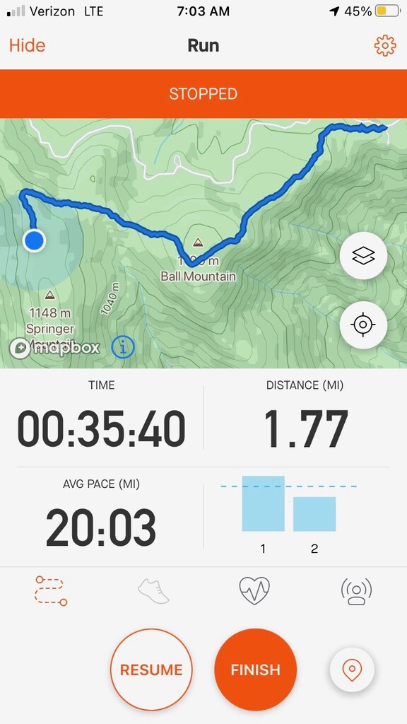
At Three Forks, with 6 miles and 1800' of gain remaining, as sad as it sounds, I knew it would take everything I had to finish in the 2 hours left before the 24-mile mark. I felt reluctant to even retain that as a goal, and Maggie encouraged me not to; I was returning to Springer Mountain in part for redemption after last summer's bittersweet finish there on the GA AT, and part of me felt certain that if I let myself get attached to another time goal, I would have my heart broken again, missing it by just a few minutes. But I just couldn't help but try. And so I ran, really ran again, on the flat portions and tried to just keep moving no matter what, even when both my headlamp and Garmin died(!) at Big Stamp Gap where I crossed FS-42 onto Ball and Springer Mountains, which were veiled in morning fog. (I quickly started a Strava segment on my phone to track from there until the finish.) I was frankly surprised, and of course relieved, when I indeed arrived at the BMT terminus at 7:03 AM Sunday. I took some photos, unwrapped a candy bar I was too tired to eat, and began the slowest downhill 0.7 mile hike of my life, back to Maggie in the Springer parking lot.
It should go without saying that I think this route could be completed faster. The most obvious tweak would be to attempt it in a cooler season, or at least on a less hot and humid day. The season also affects the trail condition and, although the BMTA does wonderful maintenance work (thank you!!), some portions were inevitably still overgrown. I knew the trail well enough to not get lost, but the overgrowth still scraped more skin off my legs and arms than I've ever experienced, undoubtedly slowing me down at least a bit in the process. I also think the reverse direction should at least be considered; starting at Springer would make the overall route net downhill (slightly), with some easier sections in the second half, and cut the hike-in from 5.3 to 0.7 miles so that you start on slightly fresher legs (one could then camp at the state line to postpone the painful hike-out).
I do also wonder if I could have pushed just a little harder in the later miles if I'd had a prior time to chase. Being the first to try an FKT route is easier in the obvious way ("all you have to do is finish!") but harder in terms of motivating yourself to hit any particular pace. I hope that by putting up this time, I'm providing a helpful target for others. As much as I suffered through parts of this effort, I truly adore this trail; it has the GA AT's mountain views but also grassy meadows, historic bridges, quaint towns and cabins. If you've read this far then I hope you will give it a look, and when you do, please let me know how I can help!