


*Thank you God for giving me the ability to accomplish a feat like this. I am truly blessed!*
day date distance elev gain approximate locations
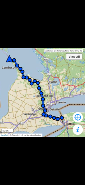
Day 1 April 28 35.01 mi 3537 ft Queenston to Ball’s Falls
Started at 8 am sharp. Parents were kind enough to drop me off at the start after spending the night in St. Catharines. The day went well overall. Just went easy and enjoyed less gnarly terrain. Ball’s Falls is really pretty and the climb out of there was tough with the heavy pack.
Day 2 Apr 29 29.03 mi 3776 ft Ball’s Falls to Felker’s Falls
Terrain starts to get more rugged today. There are a lot of wineries in this area. I also got a nice view of the Toronto skyline. Short detour in Grimsby around a pedestrian bridge that is being repaired. I ended up just outside of Hamilton.
Day 3 Apr 30 33.88 mi 4669 ft Felker’s Falls to New City Park
I saw more people this day than any other. There’s always a lot of people climbing the escarpment stairs in Hamilton. Enjoyed some easier terrain along 2 different rail trail type sections. So far things are going well!
Day 4 May 1 35.60 mi 3999 ft New City Park to Speyside
Went through Mt Nemo in the morning. Crossed under the 401 highway later. Got to see some remaining snow at the ski hill in Milton. Starting to get in the groove. Having no problem with finding water so far. Lots of streams.
Day 5 May 2 32.61 mi 3192 ft Speyside to Forks of the Credit
Speyside area is really rocky in certain parts. Hard to get in any type of rhythm. Going through Limehouse was really pretty. Got through Forks of the Credit before finding a good sleep spot for the night.
Day 6 May 3 35.46 mi 6227 ft Forks of the Credit to Mono Cliffs
Let the rain begin! And that it did. Started off with some smooth terrain which was really nice. Got into Hockley Valley eventually. Not technical but it sure is up and down. Sure glad I had good rain gear on this day. Set up camp later in the pouring rain.
Day 7 May 4 37.30 mi 5449 ft Mono Cliffs to Noisy River
Everything was still pretty wet for the morning. The sun came out in the afternoon and it was glorious! Took the time to dry my gear out for later that night. It was worth it. Got to the Noisy River area which is really beautiful!
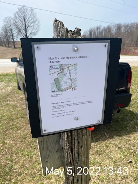
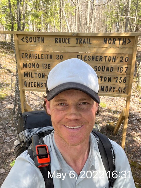
Day 8 May 5 37.47 mi 5341 ft Noisy River to Scenic Caves
Really starting to get my trail legs now. It’s giving me confidence that I can actually do this! Long way to go though. Anything can happen. Got through Devil’s Glen which was really muddy in areas. Put my feet in the river but it was really cold. Made it to the top of Blue Mountain.
Day 9 May 6 39.68 mi 5390 ft Scenic Caves to Eugenia Falls
Went across the beautiful Blue Mountains in the morning. Got the first views of Georgian Bay today. The weather has been terrific! Made my way through the beautiful village of Kimberley and climbed up Old Baldy. Tough climb! Heading south towards Eugenia now.
Day 10 May 7 39.42 mi 5738 ft Eugenia Falls to Rocklyn Creek
Saw Eugenia Falls bright and early. Then Hogg’s Falls. Hit the southern point of the Beaver Valley section and then started heading back up north. Really feeling great and loving how things are going.
Day 11 May 8 40.28 mi 3885 ft Rocklyn Creek to Sydenham Forest East
Got to go through my least favorite part of the trail today. Bognar Marsh. Super muddy. Feet got soaked on the boardwalk. The sections of boardwalk go down half a foot or so when you step on them. Really the only time your feet have to get wet on the entire trail though.
Day 12 May 9 40.99 mi 2723 ft Sydenham Forest East to Kemble Mountain
Sydenham section. Tons of rock and technical terrain. Inglis Falls is a really beautiful spot. Still feeling pretty good. It pays to take care of yourself! Lots of crevices today. Some you actually walk down in between. Pretty cool. Headed north up towards Kemble mountain.
Day 13 May 10 44.68 mi 2946 ft Kemble Mountain to Sydney Bay Bluff
Made my way through Skinner’s Bluff and then headed by Colpory’s Bay towards Wiarton. I was so excited to make it to Wiarton. I love this area! Went by the beautiful waterfront before heading up the famous spiral staircase. Then headed to Chippewas of Nawa First Nation area.
Day 14 May 11 45.33 mi 4170 ft Sydney Bay Bluff to Dyer’s Bay
Went through beautiful Hope Bay. Weather is heating up big time and water sources are becoming scarce. So I really have to be careful and make smart decisions. Went through the very tough Lions Head peninsula section before going by the waterfront. Made it up to Dyer’s Bay for only a quick nap. Getting close now!
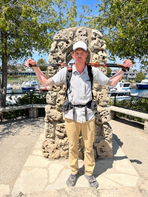
Finish May 12 32.13 mi 2612 ft Dyer’s Bay to Tobermory
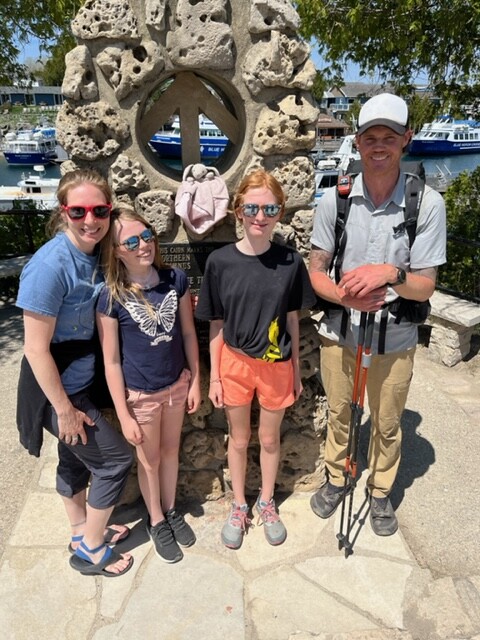
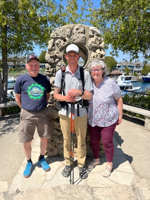
I pushed fairly hard today. Lots of easier road, snowmobile trail stuff in the morning. Then crazy technical, rocky stuff later in Bruce National Park. Loved going by the Grotto. One of my all time favorite spots. A hot day and ready to be done. Extremely proud of myself for getting it done! My family waiting for me at the cairn in Tobermory was the absolute best!
14 days 5 h 20 m 558.87 mi 63654 ft End 2 End Unsupported!
average mileage per day: 39.30 mi
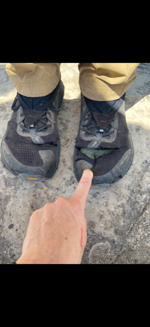
Note: All distances are from my watch which may not be 100% accurate. Also, these distances do not reflect the exact distances of the trail. These distances include wrong turns, going off trail to fetch water, etc.
Unsupported: I started with all of my food to get myself to the end. I drank water only from natural sources. I carried all of my gear from beginning to end. No pacers.
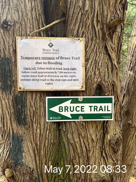
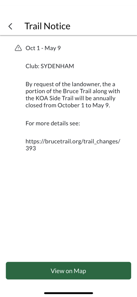
Navigation: The Bruce Trail is blazed and maintained extremely well. You could literally go end to end without a map. Unfortunately, their app and website isn’t always up to date. My plan was to follow the blazes and trail postings on site, not go by the untrusted website and app(they still had winter closures showing as of May). The first few reroutes went accordingly to plan with the reroute being well blazed. Perfect. The largest reroute was in Dundas where there is a bridge out and it is rerouted through town. There was a posting of the reroute(see pic) and once again, the reroute was blazed. The first issue was Kelso. Going by the app and website, Kelso was closed due to wet conditions. Although when I got to that section there was no trail closure posting, there were turn blazes going in and there was no blazed reroute. Since I can’t trust the online stuff, I followed the blazes and did the Kelso section. The only other issue was the KOA campground. The website and app said that the KOA section was closed until May 6 but then got extended to May 9. I ended up at that section on May 9. Once I reached the section, there was no posting on trail. There were no turn blazes to go into the section. There was just one blaze signifying to stay on the road. The road section(reroute) was blazed throughout. At this point I felt like if I did the KOA section, I’d be trespassing. The last thing I want is to disobey a private landowner and ruin it for everyone else. So I stayed consistent and followed the blazes(which I felt like I could trust). I would have loved to do that short section. I wanted to do the entire trail. I also have to follow the blazes and regulations. I know I did the right thing and feel confident about my choices. The Dundas reroute was quite a bit longer than the original section, so the overall distance might have ended up roughly the same regardless.
Blessing in disguise: I originally started this journey on April 10. I was pumped and ready to go. First 3 days went really great actually. Then on day 4 I started feeling horrible. Didn’t know what was going on. Then the vomiting started. Couldn’t keep any food or liquids down. Barely had energy to move forward at all. It all ended when I called my friend Steve from the side of a road to come pick me up. I wanted and needed off that trail. I was super disappointed. I didn’t feel like myself for about a week. Originally I thought it was bad water perhaps, but I really think I caught a bug before I started the trail. After a week or so I felt much better. I started getting lots of encouragement to give this another go. Part of me wanted to but the other part of me was still traumatized. What if I fail again? I had to find out though and I was keeping my fingers crossed the first time was just bad luck. So I made a few small adjustments and waited for a good weather window. Then on take 2, it all went so well. I truly believe that I needed to fail the first time. I think I would have ran into bad weather. I started pretty early the first time. I also believe that the few changes I made for my 2nd go, really helped me out also. Got my pack weight a little over 5 lbs lighter which is huge. And I’m sure the 3.5 days of trail time 2 weeks earlier made me stronger also. So in the end, it was all good and it all worked out. I was so blessed to have the opportunity to give it another try!
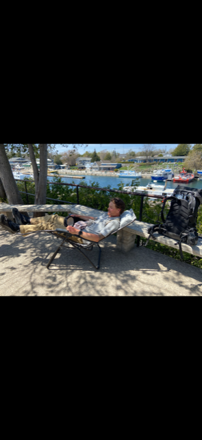
Challenge: I had been doing some unsupported FKT’s. The longest being about 5.5 days. These are tough! I had this idea to do The Bruce unsupported, but deep down I really didn’t know if I could do it. I obviously thought it was possible, but a lot has to go right. So I went into this knowing the chance of failure is extremely high. And I was right because look at what happened the first time! I will say, it’s an amazing feeling when you really challenge yourself and pull through. I started believing that I could finish this even before the halfway mark. My body was responding well. Mentally I was in a good spot. I also knew not to get overconfident because anything can truly happen. One wrong step and it could be all over. One small mistake. One piece of gear failing etc. Even the last day it was really hot and I was hurting. It wasn’t until I hit the stone path near the visitors center in Tobermory until I knew I actually did it. I said to myself out loud…you did it, you did it. I got super emotional because I had beaten those demons. I had overcome so much. I trained so hard for this. I put myself out there. I couldn’t have been more proud! Then when I hit the sidewalks in town and saw my family, it’s really hard to describe the feeling. We all took pictures and they had a nice chair waiting for me. It was a beautiful sunny day out. I just sat there with my loved ones around. They were asking me lots of questions. I was so incredibly happy just to be doing nothing. For almost 14 and a quarter days, I had been go go go. To sit there and bask in it all is a feeling I will never forget!
Unsupported support: Thank you Chantal for giving me a ride to the start for Take 1. Thank you Steve for picking me up when I got sick and taking care of me. Thank you Chantal for picking me up at Steve’s. Thank you to all who encouraged me to give it another go! Thank you mom and dad for offering to take me to Queenston to give it another go. Thank you mom, dad, Chantal and the kids for meeting me in Tobermory at the end. Thanks mom and dad for bringing me back home after an amazing day and night in Tobermory. Thanks Casey and Chantal for helping out with the Facebook posts. All these may sound like little things. But when you add up all the drive time and general effort to help me out, it’s a lot! I will be forever grateful! I’m so lucky to have the support system that I have. I truly could not do this stuff without that.
Facebook page link with more info: https://www.facebook.com/groups/236098290546890
Starting bodyweight(morning on empty stomach): 180 lbs
Finishing bodyweight: 166 lbs
Morning after FKT bodyweight(empty stomach): 169 lbs
Starting pack weight with no water: 52 lbs
End pack weight(a little food left over): sub 20 lbs