Josh's phone broke early on but he got a few photos from hikers he met along the way.
June 7th – 13th 2019 - 6 days 9 hours 45 minutes
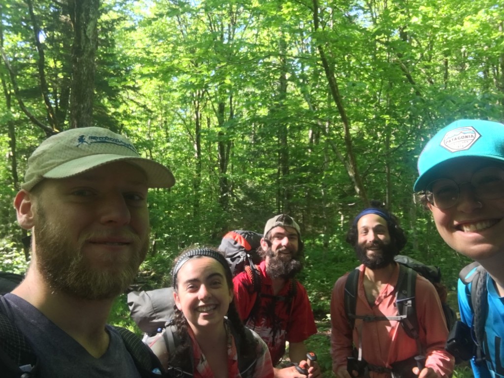
I arrived in New York on the 4th and stayed with a friend, Milkshake, who the next day would drive us up to Williamstown, Mass, so I could start my long trail hike. My tarp hadn't arrived yet, but Milkshake was getting sick and didn't want to take any risks, so I borrowed his bivi and resigned myself that I’d just have to go shelter to shelter, the same way Travis did. I planned to hike the trail in 7 days anyway, and I was umming and ahhing over whether to actually attempt the record right up until the day prior. I rounded off my most consistent training period ever in April, with an 800 mile fastpacking trip across the UK, rounding out a training block which included 2000 miles, half a million feet of ascent, and nearly 500 hours of training in 4 months. Thanks to Training For The New Alpinism. I decided to trust my training and go for the record. Resupplying nearly entirely out of the Dollar General in town, I went back to my motel room and repackaged all my food in to 6 different bags, approx. 3lbs and 6-7000 calories per day, just barely squeezing it into my pack. I had an extra bag I planned to carry in my hand for the 10 mile hike to the trail the night before. The night before in my motel, I read Travis' write up a couple times and watched Finding Traction to get myself stoked for the next week. In the morning, I bought more food on my way to the trailhead. It already wouldn't all fit in my pack but I was nerve buying for what would be my longest food carry ever, having previously carried about 210 miles worth on the CDT. I hiked up to the shelter 2.8 miles past the Mass/VT border, where I ran in to a bunch of AT hikers, and was able to relax a bit in a familiar environment and doled out some of the extra food I’d carried up as trail magic.
Day 1 - 48 miles Mass Border to William Douglas Shelter
I woke up at 4:30am along with 2 other AT hikers, packed up quickly, and back-tracked the 2.8 miles to the border. I sat on the rock opposite the sign that starts the long trail at 5:52am waiting for my inreach mini to send its first ping so I could start hiking. After filming myself saying "I’m about to start my Long Trail FKT attempt. The time is 5:55am, I have until 11:20pm on Thursday 13th to make it to Canada", I put my phone down on the rock so I had a free hand to slap some mosquitoes. Seconds later I watched it slide down the rock and into the mud. My inreach pinged and I left. 100 yards into it, I went to check my phone and the screen was cracked and none responsive. It wasn't even 6am yet and I’d already run in to my first major problem. I hiked onwards debating whether or not I should even continue, and if I did, would I even be able to have it verified if I didn't have any pictures? But I’d made a post online saying I was doing it and I couldn't bring myself to not start/quit 5 minutes in to it and look like such a moron quite so publicly. I decided my best option would be to ask other hikers to take pictures for me and email them to myself.
At Congdon Shelter I ran in to some of the AT hikers I’d stayed with the night before, borrowed their phone and took notes from Guthooks of the locations of the shelters until Maine Junction, and planned to do the same again once I got passed with other LT hikers. We took a picture together at the shelter, they wished me the best as I went on ahead. The rest of the day was pretty uneventful. It was interesting to see which areas looked familiar from my AT thru hike in 2016. Mainly it was the road crossings and shelters. The road crossing that leads into Bennington was familiar, and the next one north of there as well where I got trail magic donuts and coffee when I was here last time. Normally, after only a few hours I’m able to get into my routine of eating every hour and start getting the hunger before the end of day one on most trips. For whatever reason, that wasn't happening this time. I just wasn't eating. I kept thinking about the passage in Heather Andersons book where she went through a similar thing on her PCT FKT hike. I was trying to force food down, but was struggling to stomach it.
I got to Stratton pond Shelter before dark, and spend 10 minutes convincing myself to push further. My shoulders were sore already, and I was realizing a frameless Simple pack, with only a thin seat belt webbing hip belt was not the right choice with a starting weight of approx. 28lbs. I knew Travis' mileage for his last 2 days, my first 2 days, so knew he did 57 miles over this stretch. I continued, pushing into the night for about an hour until I got to William Douglas Shelter. It was off trail, and not wanting to do any bonus miles, I set up my bivi on trail and lay down.
Day 2 - 46 miles William Douglas to Governor Clement Shelter
Up at 4:50am, I was on the move before the alarm on my watch went off. It's not the loudest alarm and I stressed every night of the trip that I’d sleep through it, which resulted in my not sleeping that much for the first couple nights. Donning my pack that morning, my shoulders were pretty sore, but I put it down to bruising from jogging some of the flat/downhill sections and pushed on. The day started down a gentle dirt road for about a mile, which I spend brushing my teeth and messing with the fit of my pack. Travis did the last day as a big push, and assuming I’d do the same, thought if I could get close to mile 98 today (his last 2 days mileage) without pushing too much then that would be a pretty big mental boost. Without Guthooks or the trail guidebook though, I was often unsure how far or fast I was going. I worked off the basis of 3 miles per hour, which generally seemed to put me at the shelters at around the right times, so I could confirm my pace and assure myself it was all going okay. Before I started, I looked at what Stringbean and Karel Sabbe did over the LT/AT section on their FKT hikes, and hoped I’d be able to do something similar not counting for the excessive weight on my back.
Weather was good, and miles ticked along nicely. Peru peak was the first hurdle. Not so much physically, as I was still strong there, but mentally I was really struggling to find the point of all this. I wasn't thinking about quitting, but I was telling myself I could quit once I made it half way point, at least that wouldn't seem quite so pathetic. But the only reason I could find to keep going was because I’d said publicly on Instagram I was doing this. That's not true, I’ve wanted to attempt some of the bigger FKT's on different long trails since my CDT hike 2 years ago. But part of the reason I said I was doing it publicly was definitely to hold myself somewhat accountable. It ticked through my head about how thru hiking the long trails generally has a success rate of around 30%, and in Ultrarunning there's races that take pride in even lower finishing rates. Yet the reason I kept coming back to was because I didn't want to be seen as a failure, a loser, or a poser by a few friends I’ve made over the years on various trips, but in reality they're people I barely know. I knew I could explain what went wrong to friends back home, but not so much to some of those I rarely see. I was struggling with why was I continuing to push myself towards something I didn't think I’d actually be able to do, at least not this time having made a handful of critical gear mistakes, to prove something to people I barely even really know. These thoughts persisted all through the day, and deep into the next day too.
After Peru Peak Shelter, I pulled my headphones out of my shoulder strap pocket and put them in, searching for my phone to listen to a podcast. It dawned on me the real damage not having a phone would do for my hike. I knew the trail was blazed well enough that I wouldn't need it to navigate, and could get the shelter information from other hikers. But being stuck in my own head with my own negative thoughts, struggling to find the why, for upwards of 15 hours a day for 6 days whilst pushing myself so much physically. That's the real damage not having a phone did.
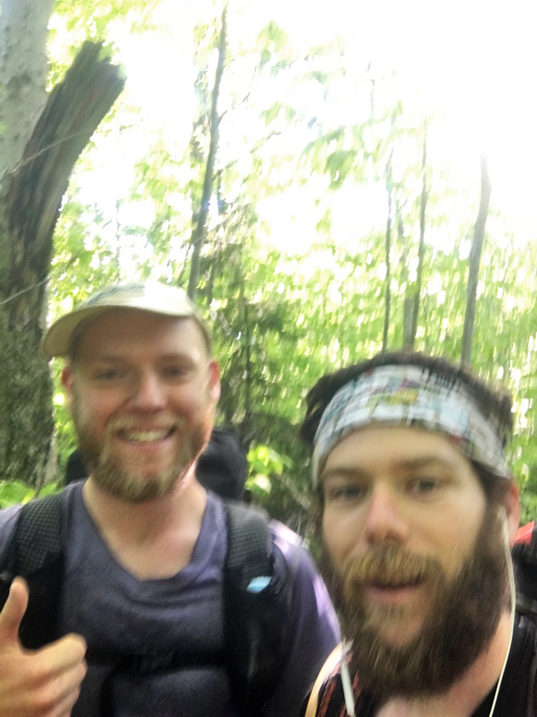
The realization sent me further in to a bonk and I didn't really pay much attention to what was going on around me the rest of the day until I arrived at Minerva Hinchey Shelter. I stopped there doing a really good job feeling sorry for myself. I was surrounded by AT hikers who, once they found out I was going for a record, were all super stoked about it and their support helped pull me out of the slump. Everyone asked if there was anything they could do to help, but unsurprisingly nobody wanted to hike to the next shelter that far into the evening. One of them went by Nemo, or Neemor, and also had a palante pack, but in the moment I didn't stop to ask if it was Neemor from youtube. We took a picture, I forced myself to eat something, despite still not wanting to, and I went on. I was being weirdly intense with my approach to everything . I knew Killington was coming up at some point soon, but wasn't sure if it was before or after the next shelter. Luckily it was after. I cross a bridge, and get to a road right around the time I thought I’d be getting to the shelter assuming normal 3mph pace. The shelter wasn't here and it was dark now. I'm much better starting my day in the dark than finishing it in the dark. I know I slow down a lot hiking into the night, so was hoping to not do too much of it until the latter stages of the trail. But this shelter just wasn't there, and I was beginning to convince myself I’d missed a sign for it in the dark, and I’d have to bivi on the trail somewhere and just hope it didn't rain. I gave myself to 9:30pm before I’d just pitch up on the side of the trail. Right at the last minute I arrive at the shelter. I'm the only one there. Sitting under the porch I force down a bag of chocolate coated nuts. I’ve eaten maybe 2lbs of food, a third of the amount I’d expected to have eaten by this point. With my shoulders hurting so much, this was not good news.
Day 3 - 44 miles Governor Clement to Boyce Shelter
Before I begin the climb up Killington, I rub hand sanitizer between my legs and on shoulders, as what I thought was just bruising was actually pretty bad chafing. Touching them, my shoulders had been bleeding at some point, and this is all I had to clean it and dry it out. I don my pack again, and noticed my hips are chafed as well, probably from pulling the webbing hip belt too tight, to try and relieve the pain from my shoulders. They hurt so much, and my pack weight just isn't going down fast enough. I pause and put some hand sanitizer on the new tender spots. I decide to force myself to start eating to my normal pattern, at least every hour when my watch beeps. I've got a surplus of at least 4.5lbs of extra food. But I can't stomach the peanut butter flavoured things, or the crushed up oatmeal pies, which make up a good chunk of my food. I've always pride myself in not really having stomach issues, and being able to eat anything, whilst thru hiking and during ultras. But for the first, and worst, time in my hiking career - I’m being a picky eater. At each road crossing I spend an extra couple minutes looking around for a trash can so I can dump out some of the extra food and lighten my pack that way. There aren't any.
At around 11am I reach Maine Junction, where the LT and the AT split up. Two hikers were ahead of me, but I couldn't catch them in time to take a picture at the junction. A few hundred feet past the junction, I sit on a rock and take 5 minutes to force down some oreos and think about the fact I’m now on completely unknown terrain. It's well known that the northern long trail is the harder section, but I had no idea when the hard part properly started.
The trail all looked very samey for the next few hours, and you could easily be mistaken for thinking it's just winding round in circles. Sucker Brook Shelter comes and I meet a family section hiking the LT, with their packs in a circle on the ground. I get talking and ask if they've got a list of shelters, map, or guthooks. I borrow the Husbands phone and spend the next 20 minutes making detailed notes of all the main features for the rest of the trail. Wasting time, but at least then I’ll have some reference for where I am and how far I’m going. They mention where they're going, and in a passing comment I mentioned I was there yesterday. They're shocked, and it comes up that I’m going for a speed record, though I still don't really think I’m going to make it so am trying to not to tell anyone to avoid further embarrassment. As I hand his phone back, I notice his Wife is filming me, excited to meet someone going for a record I guess, and I avoid looking directly at them as I wish them the best and go on my way. On the AT everyone seemed to think I was stupid for "hiking fast" at 22 miles per day, but on the LT, with the mention of a record everyone gets totally behind it.
Since I’m not eating my pack weight down, I’ve been avoiding carrying water to compensate for it, and as such I’ve not been drinking enough. The last climb of the day around Kirby Peak I was pretty dehydrated. Having not had any water for the whole climb, I was sucking drops out of my bottles to moisten my throat a bit at least. Again, I get to Boyce shelter in the dark and have the shelter to myself. There's a gallon jug in the shelter, so I fill that up along with my 2 bottles and purposefully drink extra that evening.
I woke to a steady drizzle around 2am, went to the toilet, drank more water, and went back to sleep hoping this rain wouldn't last.
Day 4 - 36 miles Boyce to Montclair Glen Shelter
On my handwritten list of shelters, I had Cowles Cove and Bamforth Ridge. I was aiming for the latter, but given the looming threat of bad weather was realistically expecting to stop at the former. The day began with a slap in the face. And another. And another. And another. I'm getting hit in the face by a tree every couple minutes now. The trail is totally overgrown and with a number of blow downs, in places feels like straight up bush whacking.
After just over an hour of this, I get to this fantastic vista. But as I’m looking for the way to go, a little ways back down the way I came, I spot a blue blaze. Shit. How long have I been going down a side trail? Backtracking I see what looks like a trail with a downed tree and bushwhack round it, only to not find a trail on the other side. I'm looking around for close to 15 minutes carefully retracing my steps trying to find where I went wrong. I hit a spot were the trail forks, two white blazed trails, neither obviously heading north. I think for a minute, and remember I hadn't done any major climbing so far this morning, so take the left fork that heads down hill, and luckily, not long after, hit skyline lodge, where I see another hiker just waking up for the morning.
I'd promised myself I wasn't going to stop for a break until I got to Cooley Glen shelter at the very least. I had no idea where Travis would have been at this point and was starting to stress over the thought of having a shorter day. Bamforth Ridge would be a big push given the terrain, and it still would have only been 41 miles. I needed to do another big mileage day, and stop this decline of 2 miles per day. There wasn't a spring on the way down to the road crossing, so I was dehydrated again going up Mt Abe. At the Ski resort not far from the summit, I lost the trail again, and ended up dropping about 1500ft in height by going down the ski trails around Lincoln Peak. It didn't feel right at all, but I debated continuing all the way down to the bottom. Taking a wrong turn and dropping off the mountain would be a really easy out for all of this, an easy excuse to quit, plus I was still partly thinking the couple blazes I saw did actually sent me down this way. But if I quit now, the past 4 days have been for nothing. It's no longer about proving I’m not a poser, it's about not wanting to waste all the effort I’ve already put in to this. I climbed up by the track straight under the ski lift, and picked up the trail again, which headed in the opposite direction to the way I turned off. I blamed this stupid mistake whenever I felt weak on a climb for the rest of the day.
I reach Cowles Cove just before 6pm, lay down on my back, and stick my legs in the air letting the blood drain out my feet a bit. Still laying on my back, I read the sign in the shelter saying this next 5 miles over burnt rocks to Montclair Glen Shelter could take 4-5 hours and get super motivated by it for 2 reasons. I remember Travis stayed at Montclair Glen, and I’m not taking 4 hours to do 5 miles. After 5 minutes of putting my feet up, the race is on and I’m mentally doing the best I've done all day knowing I’d now be at the same shelter Travis stayed at and since I knew I wasn't a whole day behind or ahead, I must be on his pace. It's already pretty windy, and feels like a storm is coming, I didn't want to get caught out of Burnt Rocks in the dark, and I was determined to prove that sign wrong. I start flying along and do the first mile in 21 minutes. I've got to do the next 4 miles in under 3h40m. Can they really be that hard? I start up some of the more scramble-y sections, running where I can. On top of the first exposed rock section, the wind is howling now, and I start feeling the first few drops of rain. I eat 5 snacks from my bottom pocket while walking atop the rocks. When it rains my hands go totally white (Reynauds) and I lose most of their functionality so eating becomes a very difficult task. I made it to Montclair Glen in about 2 hours 15 minutes, finishing the day before 8:30pm. The first time I stopped before dark. I want to keep going, but was hopeful by spending the night the storm would pass and camels hump wouldn't be quite so wet. I took advantage of the opportunity to do some basic chores and maintenance. Cleaning the mud off my legs, shoes, arms. Washing my face, and cleaning off odd bits of dry blood all over my body from all the tree slapping that morning. Reapplying hand santizer to all the sensitive areas, and use an antiseptic wipe on my blisters.
Day 5 - 32 miles Montclair to Taft Lodge
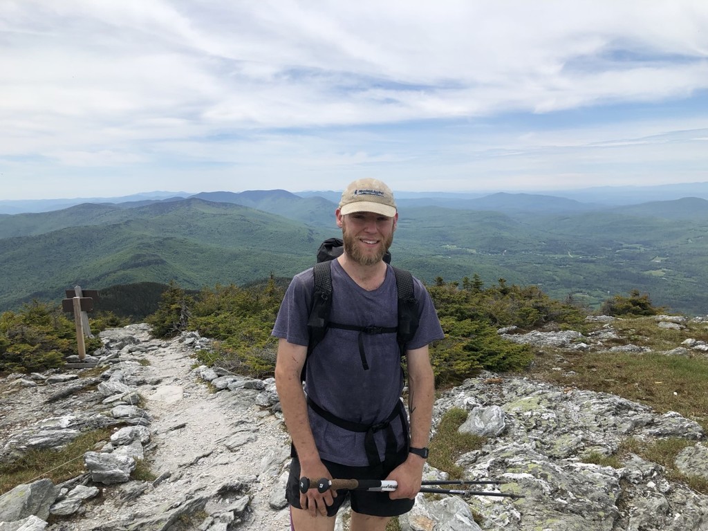
Days 2 and 3 were the mental crutch days, with struggling to figure out why I’m actually doing this and not knowing where I was in relation to the record pace, today was the physical crutch day. I still can't find my way, but I’ve put so much effort in now I’m not going to see it wasted by quitting. At the very least, today I have to do Camel’s Hump and Mansfield today. If not back up the other side to Sterling Pond Shelter as well. And the weather is still storming. Both myself, and the couple there were planning to get an early start that day, heading opposite directions. But neither of us could get ourselves out the shelter at 5am. We were dry, it was cold, wet, and windy and I had Camels Hump to climb. I get out the shelter at 6:30. The weather hadn't got any better, but I was getting stressed and forced myself out. As I get up to the alpine zone, and the wind starts to properly throw you around, I realize why the record is set southbound now. Best case, you can pick your start date around the next 3 days or so of weather. So if you can only confirm 3 good days of weather, you want the north to be the dry part. The southern part being wet is annoying, and the mud puddles suck up a lot of energy. But they do that up north as well. The exposed rock sections, and the big slabby rocks and huge roots slow your pace down so much anyway that when they're wet, you're reduced to crawling speeds. At the summit of camel’s hump, my lower half is soaked to the bone. I notice a slight relief around my thighs, as my blood crusted shorts liner softens up a little. For a few miles, the descent goes down treacherously slippy rocks and ankle-deep mud until it hits a nicely graded stretch of wide, groomed trail until it reaches parking.
There's 4 miles on paved roads and flat farmlands, crossing a bridge over the river and under a tunnel. That lets me make up a bit of time moving 3.5mph, whilst further soaking everything I’m wearing in the long grass. Bamforth Lodge and Duck Brook shelters go by, and my feet are starting to feel like I’m walking on cheese graters. They've been consistently damp for the past 4 days, but now they've been totally soaked all of the 5th day so far, and I can feel more blisters are coming quickly. I need to stop at the next shelter and do something about my feet before they get worse. The next shelter is Buchanan Lodge. 0.3 miles downhill on a side trail that had turned in to a bit of a mud slide. Carefully making my way down, it was a 10-minute detour each way, so I stopped for an extended break to make it worthwhile, and so I can dry my feet out. Sitting out on the porch, I pull my socks off and start to panic slightly. It's too late. The damage has already been done and my feet are not looking good. The middle toe on my right foot is a balloon. The maceration makes it look much worse, but the new blisters are obvious. Safety pin meets flame as I get to work draining them and taping them back up, trying to mitigate further damage. Going to put my shoes back on is tight. I have to totally slacken off all the laces now, as my feet have swollen up so much and my toes are so tender getting them back in shoes that are now too small is painful. I get back to the trail a full 50 minutes later, still hobbling a bit from the pain of new blisters and start climbing again.
Towards the end of the day the worst of the rain has passed, but as I head over from the Forehead to the Chin of Mansfield the wind is still howling. My water bottles get blown out the side pockets of my pack and I have to run to grab them, stepping outside of the roped pathway through the alpine zone. Hiding from the wind behind a couple boulders in between some small trees, I stow my poles, grab my fleece, rain jacket, buff and gloves to get warm again, and put my water bottles inside my pack to keep them safe. It's not unsafe conditions to be up here, but it's not like you want to be hanging around in this weather either. The clouds break for a moment as I summit the Chin, just enough to let me know all the climbing is behind me, and I start the descent down to Taff Lodge, arriving at an awkward time. Too early to call it an end for the day, but too late to make it to Sterling pond without arriving late in to the night. So I use the extra time at the end of the day to tend to my wounds again with hand sanitizer, dangle my feet in the air to let the blood flow out of them and eat. For the first time I’m actually feeling the type of hunger I expected, and manage to eat a couple pounds of food weight of my pack.
Day 6 - 44 miles Taft Lodge to Tillotson Camp
It took me nearly 90 minutes to make the 2 miles down to the road crossing at Smugglers Notch. I walk back and forth along the boardwalk a couple times, unable to see the blaze on the north side leading back up the hill towards Sterling Pond. My feet were in total agony. I used the rest of my tape and bandages to wrap up the blisters the best I can, but I’m struggling to tell where toe ends and blister begins on at least 4 toes. I know it's a pointless endeavor anyway, since as soon as they get submerged in a mud puddle, the tape starts slipping off. But mentally it helps to know I’m doing something. Around 8 miles into the day, some time before I get to Sterling Pond Shelter, my feet are close to numb again. Scared of having to go through the same thing again tomorrow, I start to convince myself to just push straight through to the end, it's a little under 60 miles to go. Travis pushed 57 miles in the final stretch, so I expected to do something like this anyway.
I don't really remember much of this day terrain wise. It wasn't a comfortable day. The terrain is so uneven, with blistered feet, you have to so carefully watch every foot placement. The section around Morse and Sterling Peak really kicked my arse, and the 0.4 my climb up Whiteface took about 25 minutes. Grabbing on to rocks and roots to get up and down the wet slabs. I've always strongly believed taking ibuprofen/NSAIDs for a thru hike is the completely wrong approach, and you need to address what’s causing you the pain, not just cover it up. On the summit of Whiteface I broke my golden rule. Took down 4 ibuprofen and chugged some water. If my feet weren't in such a state, this would have been the last real obstacle of the trail. But my feet were in the worst shape they'd ever been in, so every uneven step was proving to be a much bigger obstacle than it should have been.
Towards the end of the trail, the shelter names change from being called shelters to camps. I didn't know this, and thought there was a 25 mile gap between shelters, from Roundtop to Atlas Valley. Luckily, arriving at Corliss Camp to find a 4-sided wooden hut I realized it was just a name change. I'm struggling with dealing with the pain in my feet. I expected this to hurt physically, but more in the muscular sense. I didn't expect the pain to be actual hurting pain from blisters and scabbed over chaffing.
The climb up Belvidere Mountain, I have this incredible red sun set shining through the trees. I try to get to the summit before it totally sets, but miss it by 15 minutes. At around 11pm I finally arrive in Tillotson camp, exhausted. I hadn't forgot I was going to push through this, so as to not have to go through the pain of warming my feet up again, but I needed a bit of rest. The compromise I find is to set my alarm for 2am and to push out after a couple hours sleep.
Day 7 - 23 miles Tillotson to the border
I just had no motivation to get going as my alarm went. I'd done the math, and knew I had to make 23 miles in 19 hours in order to break the record. In that moment, all motivation of pushing it goes out the window. I don't want to push the pain anymore. I couldn't bring myself to get up at 2am to push onwards like I’d originally planned. Or at 3am. Or 4am. At 4:30am I got myself up and started hanging my feet off the side of the bunk letting blood flow to them for ten minutes before I put any weight on them. The next step is to slowly apply pressure on the worst of the blisters to get them used to the pain again. I've been wearing compression socks as sleep socks, but couldn't bring myself to take them off for the last day. I didn't want to see my feet again. I rolled them down just enough to expose my ankles, and duct taped them up over the spots where my latest blisters are forming, then pull my hiking socks on over my compression socks so I can begin the final death march. Every step hurt enough to make me question if I could actually finish. It was about 4.5 miles to the road from Tillotson, and I kept telling myself if I don't make it there in 3 and a half hours, then I’ll hitch into town and call it quits. I made it in 2 hours 30.
I'd been told Jay Peak was the last hard stretch of the trail, but didn't know how long the hard stretch would last. To keep my mind occupied and stop focusing on the pain in my feet, I try to figure out how much hard stuff could be left. I remember something I read on Alicia Hudelsons write up from her attempt, that the last 4 miles were surprisingly easy. At the road crossing, the hard section around Jay Peak could be at most 15 miles. At the road crossing just before Jay Peak, I think I’d had it that the hard section could be at most 8.5 miles long, before I get to those last 4 easy miles. I climb the south side of Jay Peak at the same 2mph pace I’d been going for most of the day. Dreading the hard section that is to come on the north side, but reassuring myself that it can only last 6.5 miles now. On the decent, I’m waiting for the hard section to come. I'd been dreading this bit since I got told about it at Montclair Lodge days prior, and all that worrying did a good job of taking my mind of my blisters, but it never really got any harder than it was the rest of the time. Every step sucked, but that was because of my feet and the continuously uneven terrain, but there wasn't any more throwing yourself down wet, slabby rocks or knee-high roots. And I didn't fall on my arse once on the descent of Jay Peak. I'm still moving slowly though, laughing at the irony that I’m about to become the fastest person to hike the long trail, yet I’m currently the slowest moving person on the Long Trail. That is, until I see the back of another hiker, Adam. His 1mph limp due to knee pain is suddenly making my 2mph hobble look like I’m flying down the trail. We trade a few words and I gave him the rest of my Ibuprofen, hoping it will get him to the shelter at the end of the trail, so I can have some company that evening and use his resources to figure out what I’m going to do after I finish. I walk straight past Laura Woodward shelter. 8 miles to go, I’m not stopping now. I get to the last road crossing, and so begins the longest 2.6 miles of my life. I was totally unable to judge my pace, so after 1 hour had past, I was filled with hope as I’d round every corner. Knowing round one of these corners I’ll see the monument. I get my hopes up at least a dozen times, and turn my inreach on preemptively, so it can get a signal and send my final message out as soon as I get to the sign
I reached the sign at 3:39pm on June 13th.
Comments
Kudos. You rocked it.