

Jenny Abegg and I (Kaytlyn Gerbin) completed this route in just under a week, starting in the evening of Saturday 7/16 from Silver Creek Camp and finishing the following Saturday morning 7/23 at High Bridge. Upon finishing, we hopped on a shuttle and went straight to the bakery, followed by an evening relaxing and laughing with friends in Stehekin.
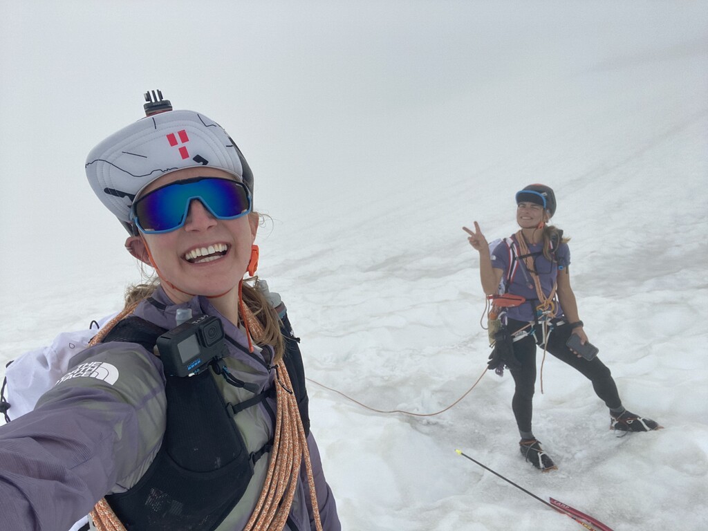
We linked up a continuous push of the following established traverses: Redoubt-Whatcom, North + South Pickets, Isolation, and Ptarmagin traverses (over Dome and Gunsights). Just one of these alpine traverses takes people anywhere from 3-7 days, in total covering ~120 miles and ~60,000 ft gain. Over 100 miles of this is off trail and full-on Cascadian: bushwhacking (from steep wet heather to vertical forests to alder swimming), rock/talus/boulders (including some 5th class), steep snow, glacier travel, etc. I've been scheming about this route for almost 3 years, and it's occupied the free space in my mind ever since. This trip was the culmination of a lifetime of mountain experience, perfectly weaving together skillsets of ultra endurance, mountain saavy, and technical alpine skills. Jenny and I found ourselves to be perfect partners – skillset wise we blended and supported each other perfectly, and our trust and communication was dialed. I’m so grateful for this week together :).
We did this in both the supported and unsupported style (FKT is "supported"). For the northern section (Silver Creek to Sourdough TH), we were unsupported. We carried all of our gear needed for 3-4 days in 27L packs (food, overnight kit, stove, 2x rad lines, glacier kits, light alpine rack, crampons/axe, etc). It was important to us to complete this section without any aid, being by far the most challenging, technical, and remote terrain in the entire trip. For Isolation and Ptarmagin (mellower terrain we were both very familiar with), we had friends join for camera footage and stoke, which made the second half a lot of fun. After the first section, our partners Ely Gerbin and Michael Hutchins offered to meet us after we came out of the Pickets, along with Steven Gnam who was taking photos/video. At the trailhead, Ely made us burgers, and we napped and resupplied gear. Jenny and I ran across Diablo Dam over to Pyramid Lake TH (including a private escort from WSDOT as they had that section of hwy closed!), where we reconnected with the guys. They joined us for the hike up to Colonial Glacier, camped for the night at the base of the glacier, and then Ely carried our overnight gear back down to the car. We did the rest of the Isolation traverse with Steven and Michael. We met Ely at Eldorado TH where he again made us dinner and kept everyone organized. Tara Fraga and Nick Danielson met us at the TH that evening, and the next day, Tara and Ely joined for the first few miles hiking up Cascade River Road (road is closed – if it was open they could have driven up while Jenny and I hiked up). Nick hopped in for additional camera footage and the 5 of us (Jenny & I, + Steven/Michael/Nick) completed the last leg of the trip (Ptarmagin Traverse over Dome and out Agnes Creek to the PCT). We were both very familiar with this section until crossing over Dome - Jenny and I led the team across the Chikamin and to the Gunsights where we shivered our way through a freezing overnight bivy before finishing the final stretch the next morning.
We are far from the first people to cover this terrain, and we poured months of research into maps, trip reports, and conversations in order to pull this off in the time that we did. Thank you to all of those who helped! The only sections that we did not recon in advance were the start and finish: Silver Creek to Whatcom Pass (Chilliwacks/Redoubt-Whatcom HR), and Gunsight Col down towards Agnes Creek. We've both done the Ptarmagin Traverse numerous times (including Jenny's first at age 11!!!), we skied the Isolation Traverse as recon in May 2022, and have been up Stettale/Colonial/Eldorado numerous times. Just 2 weeks prior I completed a recon trip of the North + South Pickets traverse in 3.5 days (from Little Beaver to Sourdough TH, with Ely Gerbin and Steven Gnam). Recon of this section was crucial-- navigation is complex and objective hazard is high.
Entry/Exit points:
While there are numerous examples of people crossing the border into Depot creek to access the Chilliwacks, this is technically illegal. Given our desire to document and share our traverse, we opted for the Silver Creek approach staying in the US (thanks to Jason for the beta). In retrospect, this approach is logistically much easier, and I’d do it again this way (despite horror stories, we found Silver Creek to not be that awful, at least this early in the season).
At the time of our trip, Downey Creek (end of Ptarmagin) has been closed since the wildfire a few years ago. We also really liked the idea of finishing in Stehekin at the end of the park boundary – and would recommend this route. Crossing the Chikamin and bushwhacking down to Agnes creek both add some spice to the end, which helps keep the final (and comparatively very mellow) section more interesting.
A few fun facts:
- We were in a complete whiteout from Silver Lake to Challenger Arm (1.5 days) which made navigation full-on. This unfortunately means we’ll have to brave the bushwhack again sometime to see how beautiful the area is.
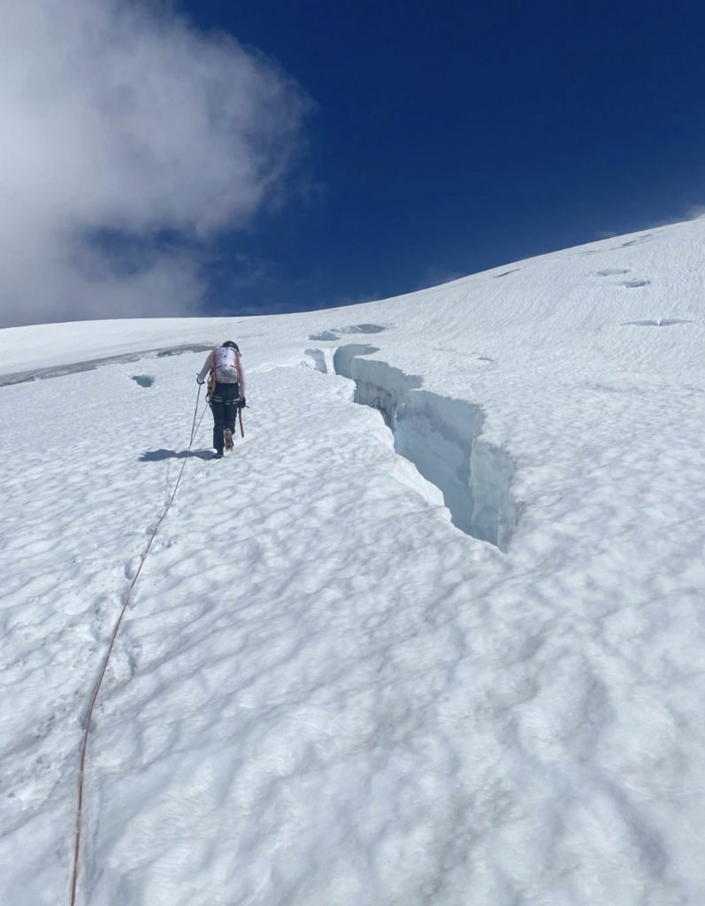
- Despite the recon 2 weeks earlier, I’d estimate over 30 feet of snow melted in the Pickets between trips. Everything looked different, some lines were out, and to top it all off somehow my gps track from this recon trip never made it over to our phones. Then (fortunately after the whiteout cleared), our phone cable broke with the phones nearly dead. We navigated the Pickets by memory and reading terrain, which was a rewarding experience.
- We each had a crampon break in the Southern Pickets. Numerous repair tricks worked for awhile, but eventually mine was just dead. The single crampon on a downhill foot may actually be the preferred style of travel in the Pickets, give it a try when moving on/off snow and heather/scrambling.
- This year's mega snowpack threatened to derail the whole trip, as we kept pushing our dates back from end of June to mid-July. However the snow coverage was welcomed and allowed for efficient travel in most places.
- The only other known continuous completion was by Don and Natala Goodman in 1990. We are so grateful for their documentation and inspiration to connect these traverses. While the style of travel was different, it's fun to read their report and see how the terrain allowed us to share a lot of the same experiences, 32 years later
Total trip stats: 123.6 miles, 58,850 ft gain, 163:38:28 elapsed (6 days, 19 hrs, 38 min), 97:03 total time moving in between camps generally from sunrise to sunset every day.
Day by day breakdown:
- D0: head start on Silver Creek. 4:52pm start, 3.8 miles, 1700 ft, 2:52
- *we had planned to just sleep at the boat drop at Silver Creek and start the following morning, but with thunderstorms in the forecast and a long bushwhack ahead, made a game-time decision to get a head start on the 'schwack to get in a better position for a high camp the following night.
- D1: Silver Creek to saddle above Indian Creek. 4:54am start, 15 miles, 8,100 ft, 14:23
- D2: Saddle to (just past) Luna Col. 5:06am start, 15.3 miles, 9,700 ft, 16:24
- D3: Luna col to Stettale Ridge. 5:09am start, 16.4 miles, 9,200 ft, 19:16:03
- D4 (part 1, our “rest day”): Stettale Ridge to Sourdough TH, 6:39am start, 7.7 miles, 1,200 ft, 3:00
- D4 (part 2, our “rest day”): Sourdough TH to Colonial Glacier Lake, 3:39pm start, 7.5 miles, 5,700 ft, 3:54
- D5: Colonial Glacier to Eldorado TH, 4:56am start, 20.0 miles, 10,000 ft, 14:58
- D6: Eldorado TH to Gunsight slabs, 6:09am start, 24.7 miles, 12,800 ft, 15:10
- D7: Gunsight slabs to High Bridge (Stehekin shuttle), 5:24am start, 14.1 miles, 2,000 ft, 7:06