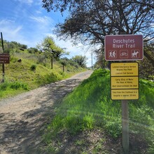
I made the attempt to lower the Deschutes River Railbed Trail FKT on the morning of Friday, April 11th. I ran from the north trailhead, out & back, unsupported. The north trailhead is adjacent to a state recreation area, so there's a gravel parking lot at the trailhead and a campground restroom for last minute preparations. I started the run just before 0625 with overcast sky, mid-40s and relatively little wind.
Gear and Fuel: My approach was to filter water along the route rather than carry the weight of a bladder. I started the route with a full 500mL UD hard flask and a water purification compression flask. I filtered water at five stream crossings, so I consumed just under 3 liters of water. I used a mix of gels and waffles along the way, eating every 30 minutes.
Overall, I'd describe the railbed as "mixed surface". There are portions which are very runnable, being a mixture of fine gravel and sand, but other sections have rockfall and loose stone cobbles which require some fancy footwork. The first 19 miles or so are railbed/unimproved-road, then comes a lovely 8-mile section where the old railroad trestle bridges crossing ravines were removed and there is some scrambling involved. There are 5 total ravines each way, for a total of 10 crossings if doing the out and back. Since I was planning to filter water, I scouted the route on a mountain bike a few weeks before this attempt and found streams at miles 3.5, 11.5, 14.5 and 21. Several streams appear seasonal, be safe and verify availability if you plan to filter water. The south end of the trail is decent ankle-rolling terrain and is also the most remote (unreliable phone service), so have a plan to be safe if something unanticipated happens.
Lastly, and the really cool part, along the route there were 3 deer, 4 bighorn sheep, 2 grouse, 4 pheasants, 1 massive eagle, and 1 tiny lizard. Cool to see so many critters along the way.

