The Portuguese Institute for Sea and Atmosphere issued severe weather warnings for storm Ingrid. Code Red for coastal events with waves of 6-8 m high, maximum up to 15 m. Code Orange for wind with wind speeds up to 100 km/h. Water crossings were high for all 3 days: both from all the inland water flowing to the ocean and the waves crashing into the coast. This information is necessary for the described detours I had to take.
Day 1 – Friday 23 January 2026
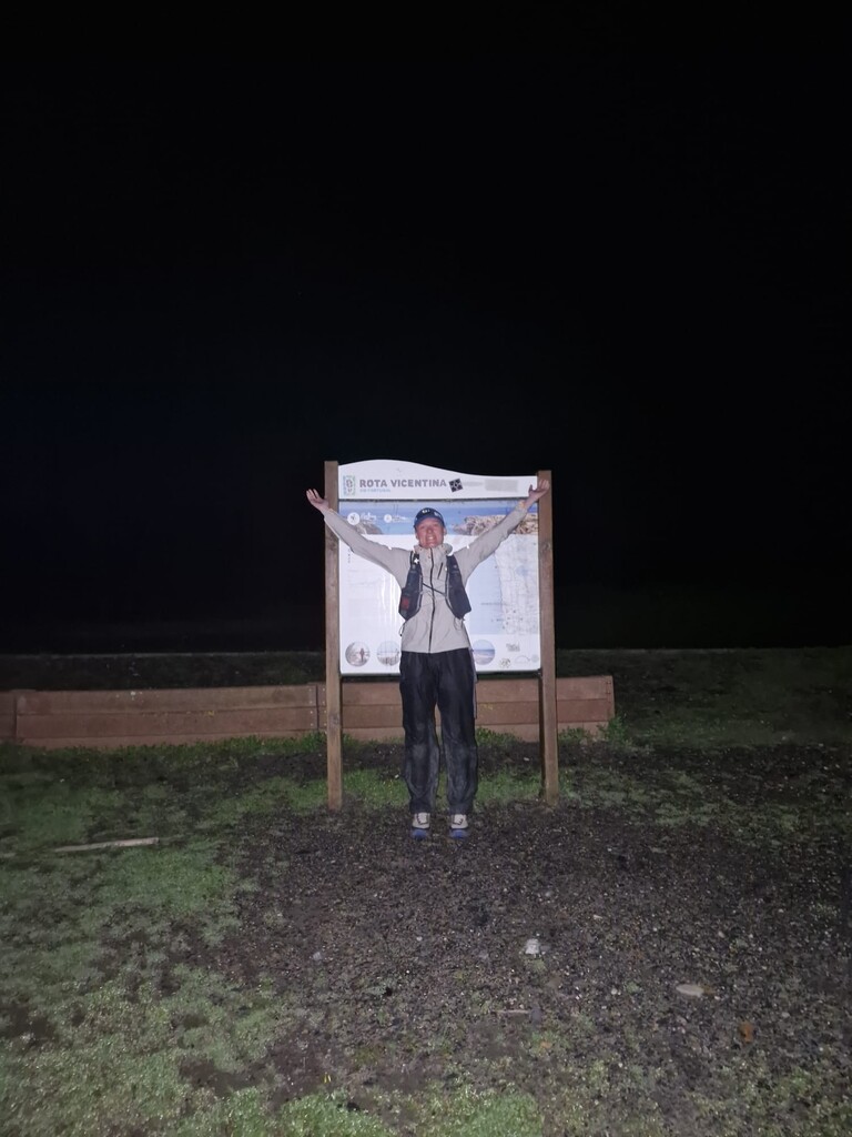
I started at 5:14 a.m. from São Torpes. Although not keen on running in the dark along cliffs, I decided on an early start because there was a pause in the chain of storms hitting the whole west coast of Portugal. Although windy, the first stage to Porto Covo flew by.
The route to Vila Nova de Milfontes was exciting when it was still dark: you hear the ocean far below while running along cliff edges, but you can’t see it (the darkness indicated the edge). As the sun rose the stunning landscape showed itself. This stage had many loose sand paths. In Vila Nova de Milfontes I had my first pastry break.
The stage to Almograve was easier to run, along fields and some sand roads. Here I stocked up on more pastries. I was enjoying the weather for as long as it lasted.
The wind was strong from the start but picked up significantly in the late morning. Hell opened up coming out of Almograve, on the road that led to the dunes and cliffs south of town. Here it crossed my mind to turn around and sit out the weather, but I also knew from the forecasts that there was no such thing as sitting it out, because this weather would continue for the rest of the day and night. It got really bad with bashing horizontal rain and hail that was very painful. Close to the cliff edge, I was thrown off the path into the bushes a couple of times. I was very thankful to reach a forest section that could break the wind.
In Cavaleiro I warmed up in a café, soaked to the bone, and fueled up with… yes, more pastries! After lots of ‘cuidado’ from the staff, I set off again. The route to Zambujeira do Mar had a bit of vegetation to stay out of the wind and the path wasn’t right on the cliff edge so that was great. The last few kilometers before town were on a road away from the coast. I had a longer pastry and warming up break in Zambujeira do Mar and I was seriously considering what to do as the wind now reached a constant 70 km/h with even higher gusts.
Coming out of Zambujeira do Mar, a worried local offered me a ride before I hit the trails again. It was tempting, but I thought, I got this far, surely, I can make it to Odeceixe. Shortly after, the first issue I came across was the Cascata da Praia dos Alteirinhos, usually a gentle stream dropping off a cliff, but now a raging water body that was far too wide to cross. One misstep and you are dragged off the edge, no thank you. I made a detour on inland roads to get back to the trail at one beach north from Praia do Carvalhal. The detour is about 1 km longer than the original route (detour #1). Later at night I learned that other people on the trail also took this detour.
I continued on the trail and followed the recent official detour at Praia da Amália due to the unstable cliffs. South from this location, 1 km away from Azenha do Mar, as the trail winded closer to the cliffs, I couldn’t set a step forward without getting thrown off my feet. I evaluated my options behind a tiny bush, and found a trail behind a row of trees leading to Azenha do Mar (detour #2, same distance as original route).
From Azenha do Mar the trail leads ~3 km very close to the cliffs, and then on a dirt road along the Rio Seixe to Odeceixe. To avoid more life-threatening situations balancing on cliff edges, I took inland roads, that eventually joined with the Historical Way to Odeceixe (detour #3, same distance as original route). This route also wasn’t without challenges because several roads were blocked from traffic by very recently fallen down trees I had to climb over. Inland the wind wasn’t any better, but at least I couldn’t fall off a cliff. I arrived in Odeceixe in the dark at 18:55 and stayed the night.
Day 2 - Saturday 24 January 2026
The storm continued through the night and morning, and therefore I could not start early. I started at 9:38 from Odeceixe. The route to Aljezur had some nice dune and coastal sections, but was dominated by inland dirt tracks along farmland. In Aljezur I found more delicious pastries, and batteries in case I needed to run in the dark tonight with the late start this morning.
From Aljezur it was mainly on dirt roads and tarmac back to the ocean at Praia da Amoreira. Then the route followed through dunes along the coast and low vegetation, before entering a forest section. A knee-height river crossing led to Arrifana. The whole day there were lots of short and sudden cold rain bursts (saw a rainbow), and it was very windy still but luckily nothing close to cliff edges so far.
The route to Carrapateira was mostly on dirt tracks and through forests (some reminding me of Kenya) and some farmlands. There was one interesting river crossing at Praia do Canal where the water came up to my belly button! Luckily the water was nearly stagnant. The last kilometers before seeing Praia do Bordeira were back in the dunes. I had to take the official alternative route (2 kms longer), because the river and sea conditions at Praia do Bordeira did not allow for a crossing.
When entering Carrapateira it got dark. I stocked up on more pastries and drinks. The shop owner and their friend gave advice that the river crossings at Praia do Amado may be impossible due to high water levels (rivers and ocean). When I got there, I saw they were right. The first river crossing may have been possible (not without danger, potentially swimming conditions and moving water), but the beach got almost completely eaten by the crashing waves. I didn’t dare to come so close to the ocean with the potential to be swept away. I took some time to find a detour that would only bypass that section of the trail. I found myself on very steep and unstable tracks doing so, and made the call for a longer detour from the route. The topography didn’t allow for short detours, and I had to go to the ER268 road. The original route also joins this road, but later in the stage than I had to (4 kms earlier along the road). I followed tracks parallel to the road when they existed, and joined the original route again 3 kms before the end of the stage (and my day) in Vila do Bispo, arriving at 21:07. Detour #4, and luckily the very last detour, was about 1 km shorter than original route, but with plenty of elevation change.
Day 3 – Sunday 25 January 2026
I left Vila do Bispo at 6:49. The start was easy along dirt roads towards the coast. At the coast it got much harder because the trail was a field of pointy rocks. Already just outside of Vila do Bispo I could see the light from the lighthouse of Cabo de São Vicente, the most western point on this trail. I seemed so far away, but I got closer with every step. With blasting headwind I reached the lighthouse, also knowing that soon I would have the wind in my back (for the first time!) heading eastward. The remainder of the route to Sagres was not very pretty, although impressive to get sprayed with ocean water while the ocean is 75 m below.
In Sagres I needed a proper food break, I didn’t have dinner last night because I was too late and a few soggy pain au chocolats didn’t do the trick. With new energy I headed to Salema. From Sagres to Lagos I saw the most people hiking on the trail so far. The route to Salema is very beautiful with small coves and beaches, but also demanding in terms of steep ascents and descents on not so easy terrain. I was running a continuous calculation in my head if I could be on time for the train in Lagos. Salema looked touristy but almost everything was closed. I found a small shop for more pastries and took off running with a popsicle.
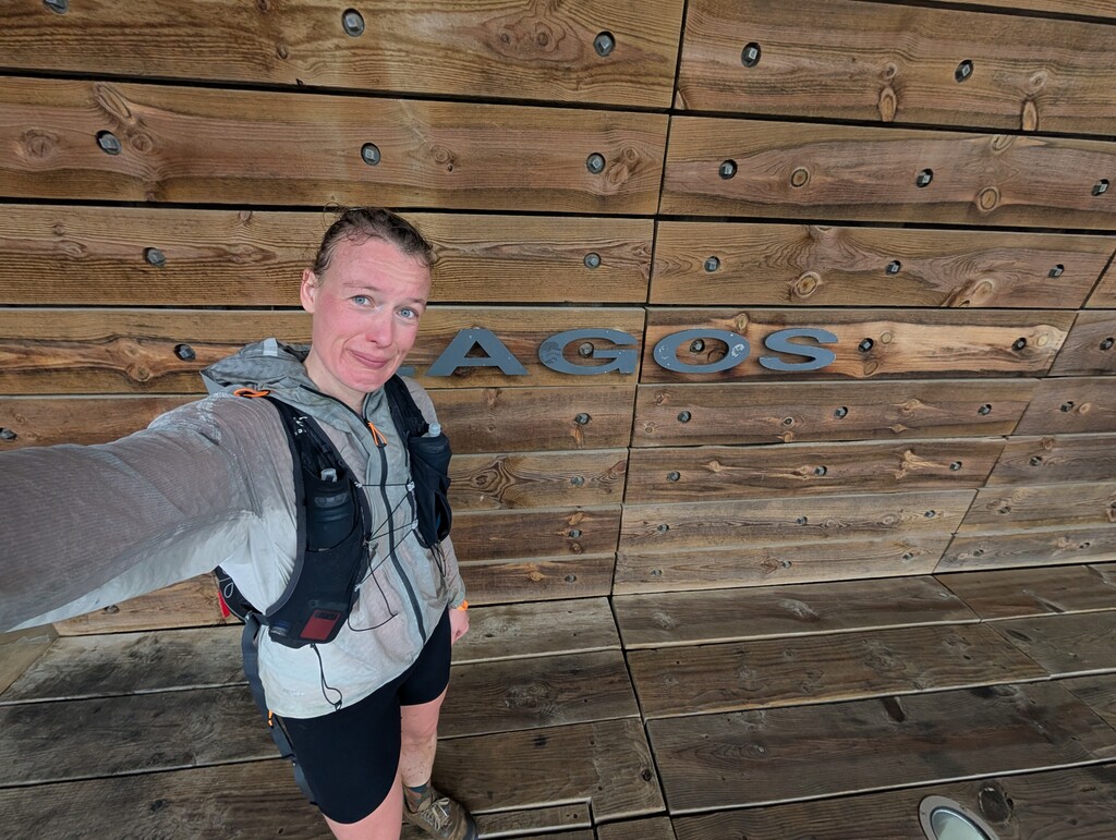
The route to Luz was also beautiful, and more runnable than the previous section. Entering Luz I knew I would make it to the train leaving at 17:20. Already earlier in the day I could see the land outcrop with the lighthouse of Ponta da Piedade at the edge of Lagos. The last section involved one main climb out of Luz, then a wide track along very unstable looking terrain, followed by nicely built boardwalks to protect the vulnerable landscape around Ponta da Piedade. Of course, another absolutely pissing rain episode came over to finish the Fishermen’s Trail in style. At 16:41 I reached the train station, which also marks the end of the route.
2 days, 11 hours, 19 minutes.
228 km, 5060 m D+.
Self-supported and solo.
I definitely got an adventure, and I am happy with my decision-making in difficult situations. Proud tears at the end, but also a bit broken mentally due to the risky situations I had to navigate.
A link with more photo and video material will follow. For now, I added the start and finish photo.
https://www.instagram.com/reel/DULizYyjbUY/?igsh=bXNremV5OG5rM2gx