


Introduction:
Ever since my first trip to the Adirondacks in November 2016, I was completely fascinated by these mountains. After ascending Marcy for the first time, I knew I wanted to complete all 46 high peaks. In the summer of 2018, I decided to attempt to get my 46 over the course of 5-6 weekend backpacking trips. This was going smoothly until I developed IT band syndrome and had to abandon the project after getting 26 or so of the peaks. It was around a year later, in the Fall of 2019, that I started learning about ultrarunning and ultralight backpacking, and I realized that by traveling fast and light, I could cover 30, 40, even 50 miles a day rather than just 20. I quickly did the math and realized that I could do all 46 peaks in around 5 days, which would be significantly faster than the current FKT. With this as my goal, I started shifting my training towards ultra-distance trail running, accumulating ultralight backpacking gear and skills, and also practicing hiking “big days” of more than 10,000 ft of elevation gain. Unfazed by the pandemic, I was on track for an attempt on the High Peaks FKT in August 2020, but I got derailed by injuries and was forced to postpone to 2021. I think his turned out for the best, because in the last year, I’ve improved my training even more, focusing more on steep, technical mountain running and more and more vertical, and today I am just a much better trail runner than I was a year ago.
In the last year I also developed a new strategy for the High Peaks FKT to play to my strength as a runner. Basically, my plan was to move my “base camp” (consisting of tent, sleeping bag, bear canister, and future days’ food supply), as little as possible for the entire trip, making out and back as well as big loop excursions from the base camp. In some ways this is kind of obvious, and no one is going to carry their full backpacking kit up Seymour Mountain, a short 3 mile out and back with 2000 ft of climbing, for example. However, I made some bolder decisions along this line of reasoning. For example, I decided to start at the East River Trailhead (near Upper Works), rather than at the more traditional starting point of Corey’s Road. This means that the Santanoni and Seward ranges must be done as a loop rather than “one way,” but the net result is a huge trade-off of about 20 miles of “full pack” hiking for 30 miles of “day pack” running. The rest of my route is similarly structured around a few carefully chosen base camps (near East River Trailhead, Lake Colden, Wedge Brook) with big 30-40 mile loops around these camps. The end result is a slightly longer total distance, but with fewer miles spent lugging a heavy 20+ pound pack, and most miles spent with just a light day pack that weighs a few pounds.
Style:
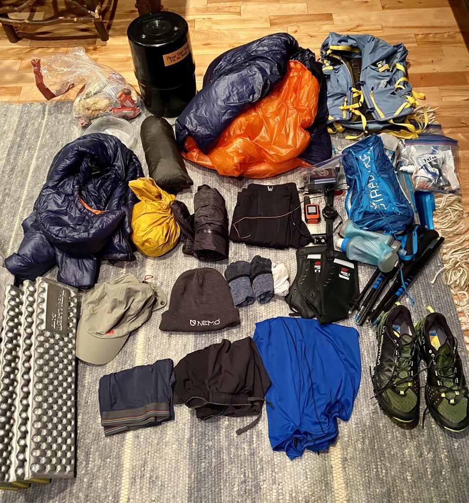
I wanted to do this FKT unsupported. This generally means carrying all of the food and supplies I need for the entire trip, taking water only from natural sources, and always traveling under my own power. In the Adirondacks, this adds an additional challenge because bear canisters are required for overnight food storage. In addition, I opted not to use any free and publicly available “amenities” in the Adirondacks, such as privies and lean-to shelters.
It was also important to me to plan my own route, which I spent many painstaking hours on fine-tuning. I did have my wife’s help in making decisions on gear and food that I ultimately packed for the trip, as well as her love and support (and food) waiting for me when I finished.
Day 1:
-
Santanoni, Couchsachraga, Panther, Seymour, Seward, Donaldson, Emmons
-
Approx. 44 miles, 13000 ft of elevation gain
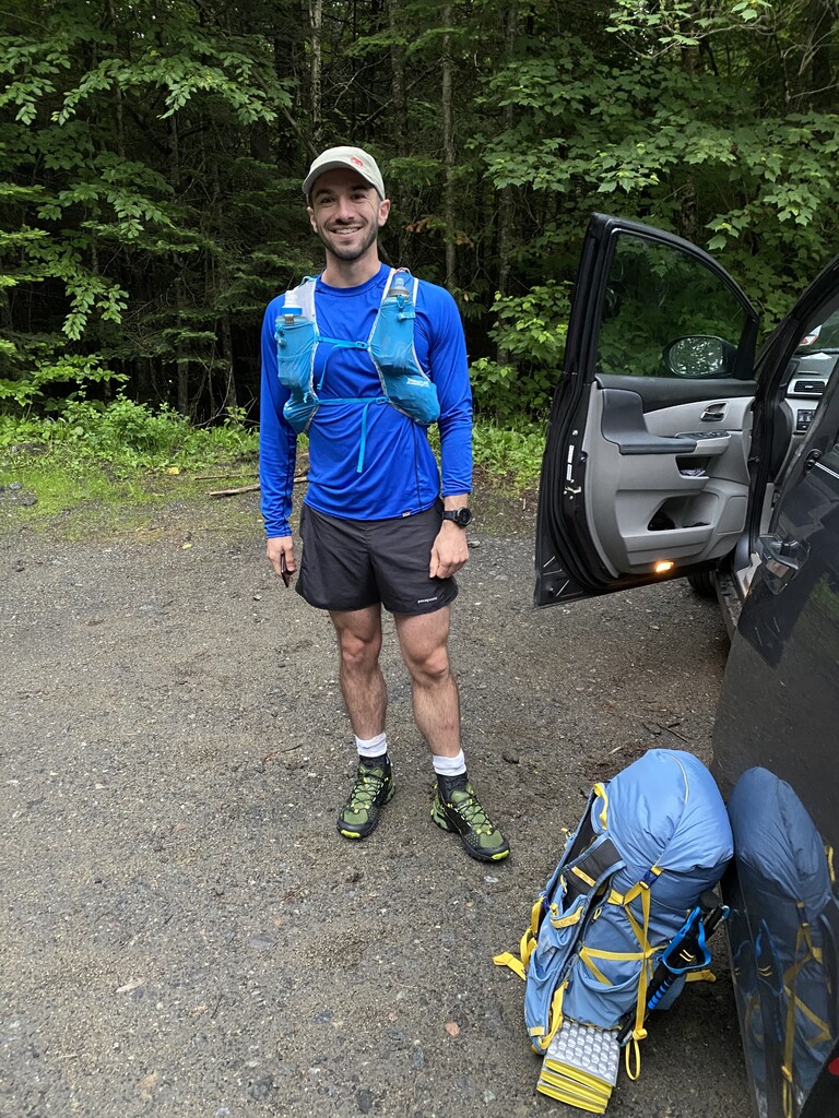
I started around 5:50am from the East River Trailhead near the Upper Works parking lot. I left my base pack at the trailhead and headed for the Santas with my lighter day pack. Weather was cool and cloudy and quickly started raining for the first several hours. I was cold and wet all day, and the herd paths were rough and generally pretty miserable, but I was moving at more or less my goal pace. My feet were wet all day which set the stage for later issues with blisters. I made it back to the starting point around 9:00pm, and carried my full pack about a half-mile from the parking lot to camp on the shore of Lake Jimmy. I slept for almost 8 hours the first night.
Day 2:
-
Allen, Marshall, Iroquois, Algonquin, Wright, Street, Nye
-
Approx. 39 miles, 13000 ft of elevation gain
I started around 6:30am from my campsite at Lake Jimmy. Carried my full pack to the Allen herd path, ran out and back, and then carried my pack to base camp at Lake Colden. From there, I traversed the MacIntyre Range (Marshall, Iroquois, Algonquin, and Wright) and sumitted Street and Nye. The weather was warmer and sunnier and I was feeling pretty good, but moving well behind my goal pace. I had intended to also summit Phelps, Tabletop, and Colden before dark, but the sun had set by the time I descended Street and Nye. I stopped for a 20 minute nap, and when I woke up I decided that I didn’t want to try to ascend Phelps, Tabletop, and Colden on my way back to base camp, as I had originally planned. So I headed straight back from Heart Lake to my base camp by Lake Colden via Avalanche Pass, returning around 1:00am and managed to sleep for about 4 hours.
Day 3:
-
Cliff, Redfield, Phelps, Tabletop, Colden, Gray, Skylight, Marcy, Haystack, Basin, Saddleback, Sawteeth, Gothics, Armstrong, Upper Wolfjaw
-
Approx 35 miles, 18000 ft of elevation gain
I started around 6am from Lake Colden. The weather was beautiful but my feet were starting to show signs of pounding. My left ankle in particular was really swollen at this point, which made it hard to run on the flats and downhills, but I still felt fine on the ascents. After making up Phelps, Tabletop, and Colden with an out and back (which probably added 6-10 mostly flat miles to my total distance), I lost my phone somewhere between the Gray herd path and Four Corners. I was relying solely on my phone for navigation, so this would completely derail my trip. I doubled back for my phone and slowly scoured the trail as I worked back toward the Gray herd path. I didn’t see it on the first pass, but after I had just given up hope, almost miraculously, I found it lying on the side of the trail. I returned to Four Corners and carried my full pack over Marcy and the entire Great Range. I had originally intended to do this in the daylight, but I was running so far behind schedule that the sun set by the time I reached Basin, and most of the Great Range was in the dark. Moving in the dark definitely slowed me down, and I had to stop to power nap and recharge my headlamp battery on the summit of Gothics, which was a challenge with the cold and wind. After Upper Wolfjaw, I skipped Lower Wolfjaw for another day and headed straight down to my intended campsite near Wedge Brook, where I slept for about 2 hours.
Day 4:
-
Colvin, Blake, Nippletop, Dial, Dix, Hough, South Dix, Macomb, Grace (East Dix), Giant, Rocky Peak Ridge
-
Approx. 40 miles, 17000 ft of elevation gain
I got a slow start around 7am from my Wedge Brook campsite, the sleep deprivation was starting to hit me, but I was excited to not have to carry my heavy pack today. Although I was behind on sleep, I was only an hour or two behind my intended pace. Once I got moving, I was feeling okay walking, but my ankle swelling had not improved, I was starting to develop some blisters, and I could not run without pain. Moving as slowly as I was, I quickly fell further behind my target. It was a hot day and managing heat and hydration on the high ridges was a challenge. I had a surprisingly easy, though long, bushwack descent from Dial to the Dix trail, and the Dix range passed uneventfully. The descent from Grace via the Bouqet River herd path really dragged on, though, because I wasn’t able to run the beautiful gentle descents. It was fully dark by the time I reached Route 73 and I walked along the road and ascended Giant and Rocky Peak Ridge in the dark. It was cold, windy, and exposed up there, slow moving in the dark, and even slower on the descents with my injured feet. I passed some sunrise hikers ascending Giant as I was descending and it was just getting light again by the time I made it to the St. Hubert’s parking lot at the AMR.
I was walking through the AMR to return to my base camp at Wedge Brook, when I was stopped by a parking official who informed that if I did not have a reservation I was not allowed to enter the AMR trails from this location. I was confused by this because I had obviously entered the AMR from the opposite direction almost 24 hours ago. I knew that in the last couple of years, the AMR had started requiring reservations, but I had thought that this was only for the parking lot, not the actual entry onto the trails. Tired and confused, I ultimately just kept walking without any further problems; I decided that since I wasn’t taking up space in the parking lot, was just passing through AMR property for a mile or so, and it was 4am with no other hikers around, I wasn’t hurting anyone. If I had decided to turn around, being low on sleep and supplies, I would likely have been forced to abandon the entire attempt. For any future attempts, I would recommend communicating directly with the AMR prior to starting, or just avoiding the private property entirely.
Day 5:
-
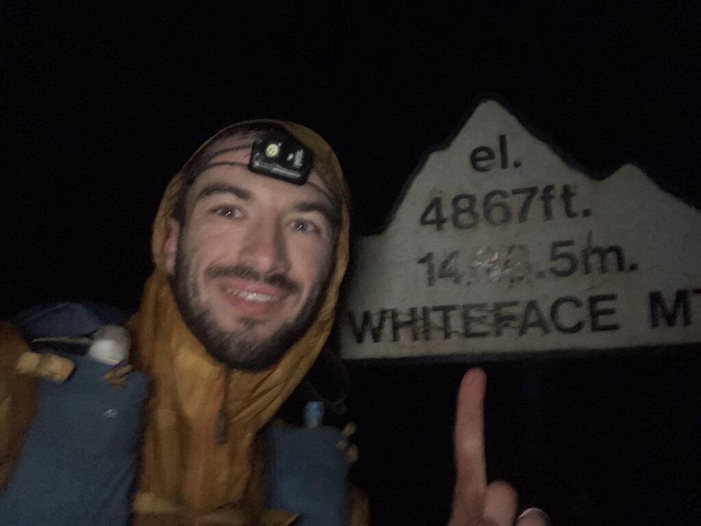
Lower Wolf Jaw, Big Slide, Porter, Cascade, Whiteface, Esther
-
Approx 34 miles, 10000 ft of elevation gain
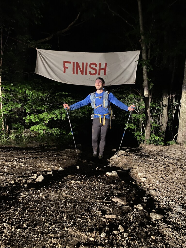
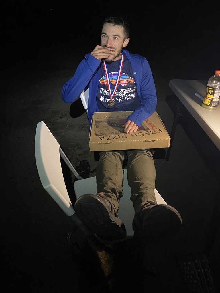
Before I started I took stock of my remaining food supplies. Over the last few days, I had been allowing myself to get ahead of my daily rations, eating into the next day’s food supply each time. While I had brought five days worth of food with me, at the start of day five, I only had about 1200 calories left (8 gels, 1 packet of Tailwind, and 1 powdered protein shake). In the previous days, I had been struggling to limit myself to about 4500 calories a day, so I knew this last day would be a new kind of challenge. Fortunately, I knew my wife was going to meet me at the finish with lots of food, so that gave me a little extra motivation. I started moving around 7:30am. The blisters on my feet had gotten worse, but I was still able to walk with reasonable comfort, and managed to summit Lower Wolf Jaw and Big Slide without too much trouble. I descended Big Slide in some light rain via the Brothers Trail and cut North to bushwack towards Porter, avoiding the trail closure on Little Porter. Unlike the previous bushwacks that I’d done on this trip, there was no semblance of a herd path through Railroad Notch. The going was extremely slow and thick, and my feet were soaked from wet underbrush. After a few hours, I finally made it up to the summit of Porter, my blistered wet feet had already gotten dramatically worse since the morning. I stopped briefly to patch up the worst of the blisters, but needed to keep going. I managed to summit Cascade in extremely windy conditions and descended to the Cascade trailhead on Route 73 slowly and with a lot of foot pain. The next 11 miles were all on roads, and went by as kind of a blur. I was starving and nearly delirious with sleep deprivation. I remember wanting to finish a half-eaten Spring Energy gel that had been discarded by the side of the road but knew it would disqualify me from an unsupported effort. At this point, I had 2 remaining gels and the packet of Tailwind, all of which I was saving for after dark and the ascent of Whiteface, when I figured I would need the energy and caffeine the most. I think I managed to walk about 3 miles per hour on the roads, making it to Connery Pond around 8:30pm, just as twilight was starting to hit. In the gathering dark, I started the ascent of Whiteface, which wasn’t so hard (my climbing legs were still strong and not causing me any pain) except for the wet trail conditions (which exasperated my already macerated and blistered feet) and some mild hallucinations. I stopped to take a 40 minute nap about 1/3 of the way up Whiteface, then continued the ascent and finally summited around 12:30am in very cold and windy conditions. From Whiteface, I slipped and stumbled down the wet trails and herd paths to Esther and then finally, sensing the imminent conclusion of my journey, “ran” (more of a quick, ungraceful stumble) down the extremely rocky trail to the Marble Mountain trailhead, where I was greeted around 3:40am by my wife, her parents, a finish line banner (shoutout to High Peaks Cyclery, apparently), and a table full of Gatorade, pizza, pasta, chicken tenders,brownies, donuts, and Pop Tarts. Never has food tasted so good!
Conclusions:
Although my “A” goal going in was 4 days, I still managed to beat my “B” goal of 5 days. I’m very proud of this performance, but I also know that it could be improved upon. I look forward to seeing this record improve in the coming years.
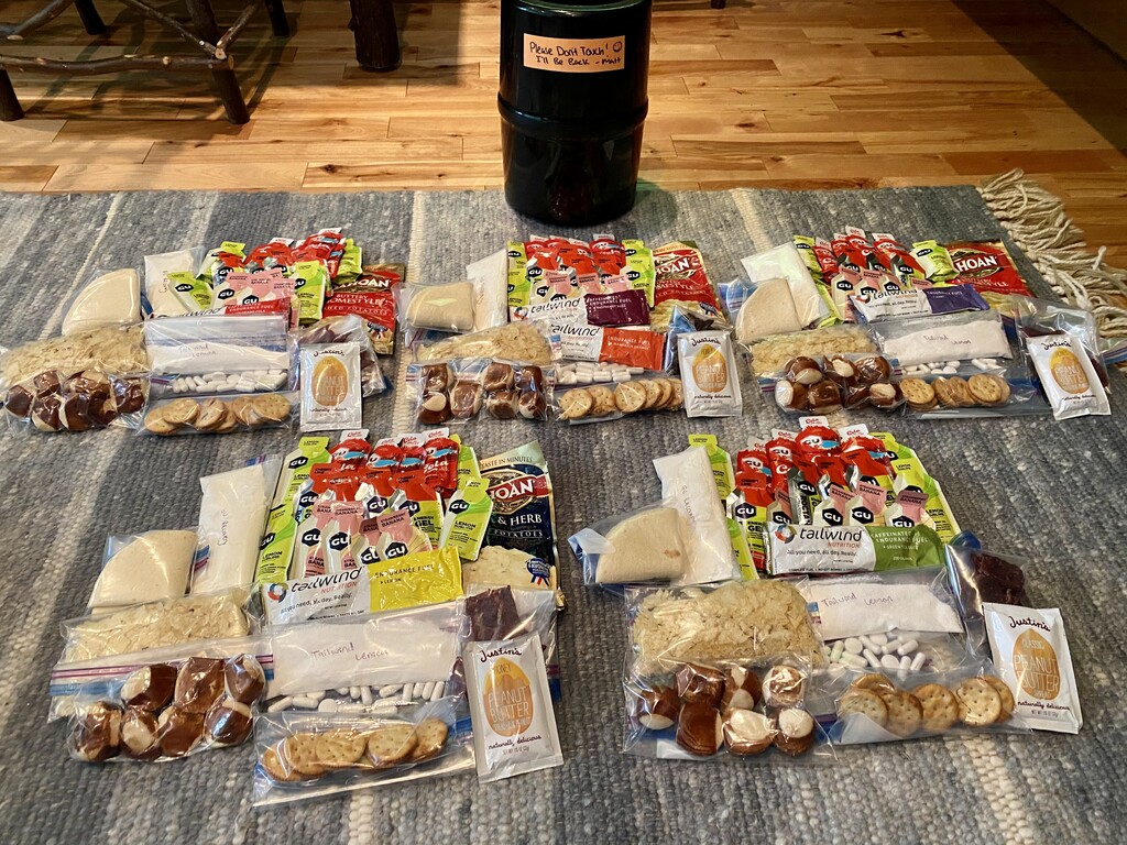
There are several things that I would have done differently based on this trip. First, I would have packed more food! Although I had essentially filled my Garcia bear canister to maximum capacity, I needed more food, and I would have considered either eating more on the first day (thus avoiding the need to fit more food in a bear canister) or bringing a second (or one larger) canister.
Second, I would have been more proactive in taking care of my feet. I should have taken more time to ensure my feet were dry in the first few days, thereby preventing some of the pain and frustration from blistering in the latter few days. Also, my snug-fitting trusty La Sportiva Bushidos, which I absolutely love for mountain runs of up to one day, did not accommodate my swollen feet well, which further added to the pain.
Finally, I would reconsider the bushwack from Marshall to Iroquois that I did on Day 2. I was under the impression that this was a seldom-used route and that my impact would be minimal. However, I found a fairly distinctive herd path all the way from the Cold Brook trail to the Iroquois summit. Upon speaking with an ADK Summit Steward on Algonquin, I learned that the DEC is aware of this herd path and is planning to close it. In retrospect, I should have descended Marshall and ascended Iroquois from Lake Colden, staying on established trails. Preserving the wilderness of the Adirondacks is more important than speed for its own sake. There are many additional points along this route where more bushwacking could save time (or at least miles), however, I encourage any future FKTers to be mindful of the impact that they are having on the area.