On May 11th Byron and I packed up and drove to the Wisconsin/Michigan border to camp in preparation for my Unsupported Attempt to run the 210-mile North Country Trail (NCT), Wisconsin segment. We stopped for a quick lunch in Ashland at the Food Co-op and then took a short walk across the street to the bakery for dessert. I drove about half way and pulled over in a Dollar Store parking lot and Byron finished the drive to the border. We had never been to that part of the state, so it took some time to find an area where we could set-up a tent that was close to the Wisconsin-Michigan border. We settled on a spot just ¼ mile from the Superior Falls. A short trail led down to Lake Superior where the local people were fishing. One of the fishermen said it would not be a problem to camp there for the night.
At that point Byron discovered his cell phone was missing. We had only stopped twice so we knew it probably dropped out of his pocket at one of the two places. We called the Co-op to find out if it was there. Unfortunately, no one had found it. So, I grabbed all the camping gear and set up our camping site and Byron drove back to Ashland with my phone. He called his phone at the places where we stopped and did not get a response. After over a hundred miles of extra driving and no luck in finding his phone, we finally settled in for the night at ten o’clock. As I lay there, I thought the irony is that we are sleeping just hundreds of feet from Lake Superior and tomorrow I will attempt a Fastest Known Time (FKT) to raise funds to help save this great body of water from permanent destruction.
Wednesday May 12th,
We got up around 4:45 a.m. and cooked a breakfast of eggs, sausage, toast and hot chocolate. We drove a mile to the bridge that separates Wisconsin and Michigan and had a short debate about which side of the bridge I should start from. We decided that a start with one foot in Michigan would be a safe choice, considering FKT guidelines. The bridge was only 50 feet long so this decision had very little impact on the finish time. The first stretch was 14 miles of road which gave me time to think of what I had just thrown myself into. I find that quite often when I first contemplate why I am doing an adventure like this, the reason changes as training and planning begin. At the beginning I question my ability to do the precise planning that is required and wonder how I’ll react to being totally alone for almost five days. Now that I was in the midst of it, I wondered if I could help make an impact on saving Lake Superior and finally, would I be able to stay mentally strong at every moment when necessary.
My goal for the first day was to make it to Copper Falls and camp just south of the park. That meant 39 miles with a full 40 lb. pack. Actually, I completed 41 miles because of getting lost. I stayed on Loon Lake and true to its name Loons do live there. As much as I love the wild sounds of a loon’s various calls, I found out they are noisy all through the night which made for interrupted sleep. I rose at 4:30 every morning, ate granola, had hot chocolate, packed up everything and was hiking by 5:30.
This was a 41-mile day.
Thursday May 13th,
I knew that this was going to be the most challenging day. I needed to complete 44 miles with a very heavy pack and hopefully make it to Lake Owen. Most of this day would be on trails with only 2 miles of road. The day before was nearly an even split between road and trail. Trails are, of course, much more interesting and one’s mind is very occupied with the task of maneuvering down the trail, but they are slower. Roads are much faster and other tasks become primary such as voice texting, checking emails (mostly deleting the junk). Also, there is very little cover from the sun. I learned that this part of the state is abundant with hemlocks. They were cut down for harvesting the bark which was sent to tanneries. The trees were left to decompose on the ground.
One thing I noticed was that water sources in Northern Wisconsin are not nearly as plentiful as in Northeastern Minnesota. I was carrying a 24 oz. bottle on my waist belt and a 50 oz. bottle with a filter cap on my vest. There were times when this was not enough water to make it to the next stream or lake. Many streams in northern Wisconsin have clay banks which makes the water full of silt. This would make a water filter inoperable in short order. I was a bit obsessed with finding drinkable water. It also caused me to consider the importance that water has, or at least should be, to everyone. It’s also why I chose WaterLegacy as the organization to support during this adventure.
I did not make it to Lake Owen, but put in 40 miles for the day.
Friday May 14th,
This was the only day of all trails and like I stated they are slower. These trails were muddy even though it had not rained for 1 and ½ weeks. This was the day I’d go just beyond the half way point, which I found very discouraging because of fatigue setting in. Also, there was very little water along the way, so I had to dip into some very questionable water sources. My goal for the day was to get to Winneboujou Bluffs.
I ran out of water an hour before reaching the bluffs. You can imagine my disappointment when I got there and didn’t find water. I had pulled a tendon in the bottom of my right foot so now I was limping. This was after 9:00 at night and it was getting dark. At this point I called Byron and asked him to check the web site to identify a water source nearby. He said Paul School Camp which was five miles away had an artisan well with a small PVC pipe sticking out of the ground. With the lack of rain, it was possible that there would be very little water coming out of the pipe. I pushed on in the dark to the camp site. All these camp sites are very primitive and designed for back packers. So, when I reached Paul’s at about 10:30, I set up camp and looked around in the dark for the well. I didn’t find it. All my meals are dehydrated so water is vital to eating. That night I had a dehydrated ice cream bar which was a 100-calorie dinner. I went to sleep with the thought that I would wake in the morning and leave without breakfast, then hike for who knows how long before finding water. This could be the end of my FKT attempt. Once again, finding drinkable water became my greatest priority! Without drinkable water, my FKT attempt would come to a dangerous end. Without water, I would dehydrate and could suffer organ failure. “water is life” took on a new meaning to me. It became clear to me that hiking in support of WaterLegacy was so appropriate and important! If you can see the value of clean water like I do consider making a donation. It was also the day that my tracker turned off for an unknown reason.
https://waterlegacy.salsalabs.org%2Fgokoppy
This was a 44-mile day.
Saturday May 15th,
The next morning, when I woke up, I looked around and saw a faint white stripe on a tree. Blue stripes mark the trail and white stripes are a spur to somewhere else. The white stripe led me to the PVC pipe with tons of water flowing out of it. I had a good breakfast, filled my water bottles to the top and started down the trail with new energy. My goal today was to make it to Mouse Branch Flowage which would leave me with the remaining 44 miles. I could feel that my pack was much lighter by now and this helped my energy even though I had a slight limp from the tendon injury. It would hurt a lot when I first started walking but after a few miles it seemed to numb out and I could move faster down the trail. I had dinner at Scott Rapids which was one of the most pleasant areas I stopped at. There was an old historic abandoned house with the river flowing in front of it and a welcoming picnic table to sit at for dinner. I knew the upcoming 44 miles would mean some late-night hiking to get to the flowage so I ate dinner earlier to keep my energy up for the hike ahead. I arrived at the Brance Flowage around 10:00 pm. I thought this would be a primitive camp site like the other, but was disappointed that it was not a camp. I found a small creek and set up my bivy just off the road and went to sleep.
This was 44 miles for the day.
Sunday May 16th,
I had 44 miles left to the finish but was doing an alternate route because a bridge was out across the Nemadji River. I didn’t know how many more miles this alternate route would add on. Two weeks prior I had done this hike for training. I started from the southern Superior Hiking Trail terminus, hiked 42 miles out and back. I didn’t know the bridge was out then so when I got to the river, I waded across with a 40 lb. pack in waist deep water to get to the other side. This was very dangerous. I called Byron and he told me of the alternate route which I took on my way back. Because of not making it all the way to the Branch Flowage two weeks earlier, I was unsure of the exact mileage to the finish.
I knew that this stretch started with 23 miles of road, 1 mile of trail, and another 12.5 miles of road. It would be hot on the pavement. I decided to get up at 1:30 in the morning and start hiking. I was wearing all my clothes because it was so cold and the fog was thick. I hiked until 6:00 in the morning and then knew I was starting to sleep walk. The dew was so heavy I could not lay down on any ground without getting wet. I kept my eyes open for an abandoned building that was close to the road where I could take a nap. I spotted a home with a cable across the drive and several outbuildings. I knew no one was home because of the cable. One of the buildings was 6 x 8 feet with no visible lock. I opened the door and saw it was a two-seater outhouse. I laid down across the seats and fell asleep immediately for 20 minutes.
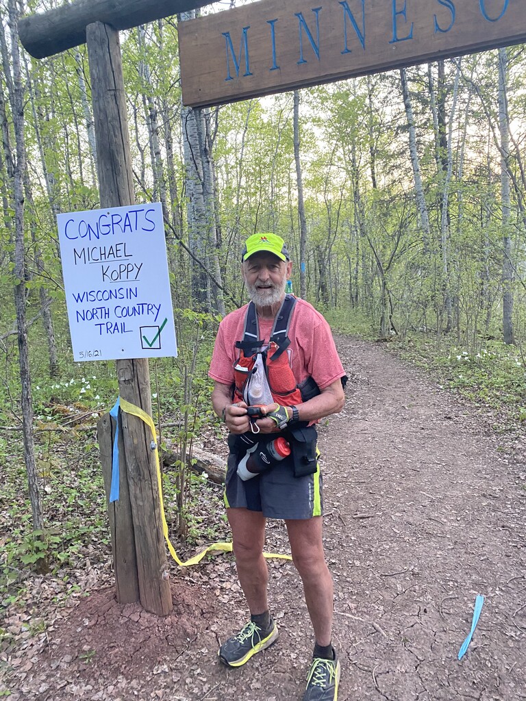
The next 6 miles to Patterson State Park were spent swatting black flies. The mile hike through the park allowed me to get water and take a lunch break with some shade. Then it was back on the road for 12.5 miles in the sun. Just before I reached the trail again a couple driving a side-by-side stopped and offered me a bottle of ice-cold water out of their cooler. I surely would have drunk that whole bottle down but told them I could not receive any outside assistance and thanked them just the same. I finished the FKT with Byron, Becky, Sue, Diane and Connie greeting me at the Minnesota border. It turned out that the alternate route was two miles longer and had the two biggest climbs in the whole hike.
My mileage was 46 miles for the day.
Each day averaged about 15 hours of hiking and slow running, except the last day was about 20 hours. The total mileage for the NCT WI segment was 212.5. My total time was 4 days 14 hours and 31 minutes.
The garmin inreach file has three of the four days but it malfunctioned on the 14th so I added the gpx file from my watch.