
Totally get if this doesn't go through because I wasn't exactly trying for any kind of fast time, but for some reason there isn't a self-supported woman's time for this trail yet, so why not. I just walked casually at a normal pace for me during daylight hours and would have been unsupported, but I bought ice cream and snacks that I didn't need, just wanted.
Porcupine on the STS
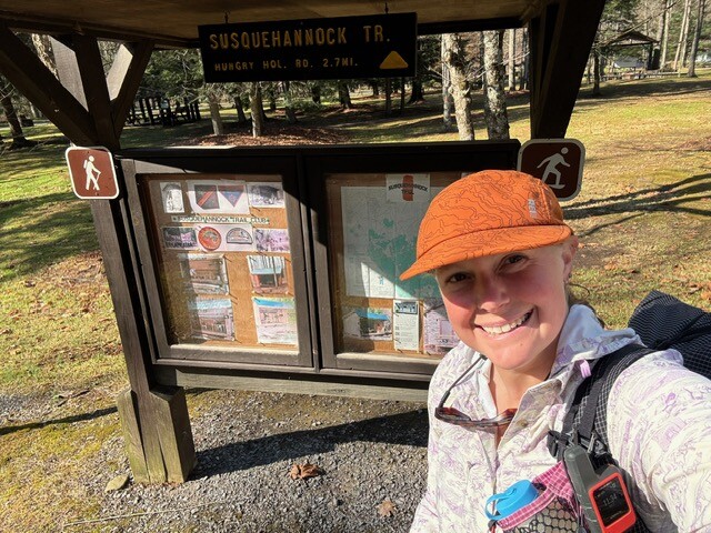
An 84-mile Susquehannock Trail System Circuit
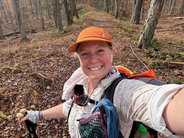
By Misty “Porcupine” Nielsen
Nov 7, 2025
November 1, 2025
It was kind of a last-minute plan to hike this trail (and by that, I mean 12 hours before I left). I had planned to do the Standing Stone trail, but my shuttle plan fell through so a loop made sense for self-sufficiency. I downloaded the Far Out map and quickly planned out the approximate campsites for a counterclockwise attack leaving the notes with my spouse. I also made a gpx file for my Garmin watch as well for backup navigation. My pack was largely packed from the last trip, so all that was left was to gather the food. I had a couple new backpacker meals I wanted to test out that were claiming 1000 calories a packet. Alarm set, clothes picked out, off to bed.
November 2, 2025
I woke up at 0630 and realized I didn't take into account the time change. Nooo! I'm going to lose an hour of daylight hiking. I got dressed, grabbed my pack and breakfast, then ran out the door. I grabbed the safety vest from the other car since it's hunting season and then began the 4-hour drive from the Baltimore area to Ole Bull State Park where I'd begin my quick trip around the loop. I chose this as the starting location since it was a touch closer to home, but more importantly to me, I could actually find information about parking here long term. The drive was pretty boring, which is always a good thing. I got to the park a little after 1100. Stopping at the office, I signed the clipboard that I was beginning my loop. After a bit of waffling on whether to wear shorts and bring rain pants or just wear pants, I made a final trip to the toilet and got underway at 1135. I chose to wear pants, good choice too because the next day was cold.
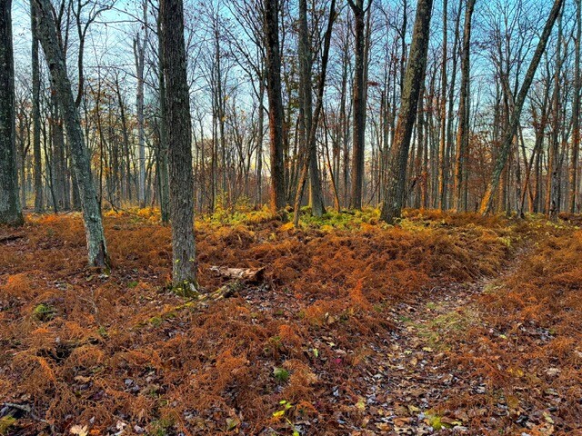
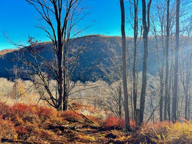
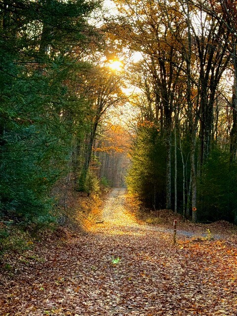
The climb out from the park was pretty casual and steady following along a nice reentrant. One nice thing about East coast hiking is the climbs end much sooner than out West, though they are often quite a bit steeper. Luckily, this one was not one of those steep climbs. At the top, I walked along the ridge for a small bit, crossing Hungry Hollow Road before dropping again to walk along another stream in a reentrant. I remember thinking this trail wouldn't be so bad to do as a hard fastpack push with running when there's more daylight. Headed down alongside Cherry run, across Yochum Run, and alongside Cross Fork Run with a road in sight for a while. I didn't expect so much of the trail to seem like it's on old fire roads. It was enjoyable. I was deep in thought when I got to the Bolich Run Shelter. I kept on past it up the wrong old road for a bit. The trail is very well marked, so it was kind of embarrassing that I went up Bolich Run as long as I did before turning back to make the turn that continues up the hill. It was a decent little climb that was very pretty and leveled off a few contours up from another stream. I made it up the climb to where the fire tower stands. I wanted to go up, but it was already 1640ish and the sun was due to set. I had to get a little farther to where I wanted to camp. I crossed 44 and passed the Cherry Springs shelter. Seemed nice, but as a woman traveling alone, I really didn't want to stay right next to a major road. I kept on along the ridge for a short bit before stopping before the Winguard/Borrous/STS junction at 1715. I found a nice spot sufficiently off trail to pitch my tent. I had dinner in the dark, tied up my Ursak, and called it a night early. I only read for maybe half an hour before I fell asleep at 2000.
Daily totals
15.53 miles
2514' gain
1366' loss
5:40:47 hours hiking
November 3, 2025
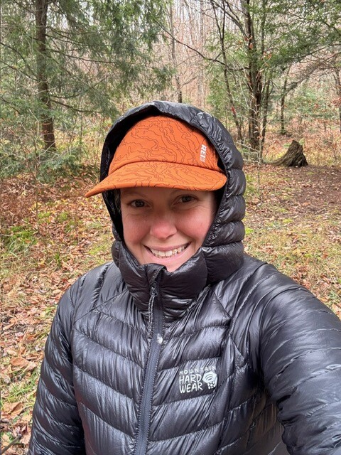
I had woken up a few times in the night to the wind picking up outside my dyneema walls. It didn't seem like a concern, and I did a pretty good sweep for widow makers before setting up where I did. I had my alarm set for 0545 to maximize daylight hiking time. I woke up then but was too cozy and didn't start packing until light started appearing. I was on trail though not too long after I wanted to be. It was still a hair before sunrise, 0634. I finished the ridge walk with the wind from the night continuing on through the day. The drop down to the W Branch Road was the typical East coast hiking I so remember. Halfway down I saw a sign saying this was Cardiac Climb. This led to a nice internal debate while I scrabbled and slipped down the rocks and wet leaves as to whether I'd rather have a steep up and switch back down or vice versa. Jury's still out on which is better for me, but I will say the best is when both are a nice grade. It was very cold down in the valley and across W Branch Road. I was glad to have camped on the ridge. Frost glistened on the grass and leaves around me. Climbing back up to the next ridge was a relief from the cold. The rest of the morning wasn't overly memorable, but still enjoyable. The forest was very pretty despite being a week or two past its fall prime. Steep down then slow up eventually crossing Ridge Road and Thompson Hollow Road where I saw the first bit of human life since starting. A car was parked on the road. A short bit later I reached the spot marked as a vista. I took the short path over but was mildly disappointed to not have much of a view. Really, it was similar to what I had been seeing. I turned back and carried on up the trail. A little later, I ran into the owners of the car, Two guys out bow hunting. We exchanged pleasantries where I said I'd be hiking at least 10 more miles, though in actuality it ended up being 17 more miles from that point. I wasn't just being cagey for my safety; I hadn't actually decided where to stop for the night. Not long after, at 1111, I came across my first trail register at the standard starting location for this hike. It's completely possible there were others, but I didn't see them. I signed in as Porcupine, my trail name bestowed upon me during the PCT where I continuously had holes in my inflatable gear. Therm-a-rest eventually just gave me a new pad since I had so much tape around the valve. Carrying on, it definitely felt like it could be a busier area with more trail junctions. I didn't see anyone. It was a cold late fall day where my mittens came off for a total of 10 minutes all day, well maybe 30 if I include lunch time.
The highest point on trail (2563') was the next high point of the day around 1140. It wasn't obvious, but I enjoyed it being marked on my map. It was reminiscent of the high point of the OR/WA sections of the PCT, just a random spot in the woods without a view. Following any high point means a drop in elevation. Heading down what's marked as Leave Hollow on Far Out led to a larger open area and stream. It was quite pretty looking out over the water. The trail followed along the stream where I saw a large number of beaver dams and pools and a few lodges, no beavers though.
I stopped for lunch around 1230 where the trail turned across the stream. I put on my puffy and heated up a scrambled egg backpacker meal. It exceeded expectations in flavor despite adding too much water. I still question the posted calorie count though.
After lunch, I found out I didn't actually cross the stream yet, but just a little branch of it. Unfortunately, there wasn't a bridge or rocks to hop on and the log chunk I used rolled when I stepped on it. Wet shoes for the rest of the day. I almost regretted only bringing one pair of socks. I packed as UL as I could for this trip. My pack with 3.5 days of food and a liter of water came in at 19lbs before I left. I followed the stream a bit and crossed another, again slipping off a log and getting my shoe newly wetted, but my feet stayed warm in their wool socks despite being wet.
Up one reentrant, across a ridge, down another reentrant, following a stream was the theme for the rest of the afternoon. I listened to some podcasts to keep my mind occupied. I crossed 44 again around 1345 and made use of the pit toilet located at Patterson State Park. Down steep grades, up steep climbs. I signed another register at 1535 after coming down from Prouty Lick Road. I followed the stream for a bit before crossing one last time and beginning the climb back up. It wasn't too long before sunset and I was hoping to find suitable camping on the ridge sometime before Rock Ridge Road. Parts of the climb were steep, but I chugged along until I got to the top right before sunset, probably 1645. Looked like lots of nice places to set up. I wandered off to the right of the trail out along the spur. Plenty of good spots! Unfortunately, the wind was starting to really howl, and the trees were bending quite a bit. There weren't many widow makers to be worried about, but it was windy enough to worry about the living trees. After wandering the ridge for 15 minutes, before finally calling it. I knew I wouldn't sleep well worrying all night about being crushed in my tent. The Wild Boy shelter wasn't all that far away, maybe an hour more of easy looking hiking to get there. The trail was nice without too many steep ups and downs. It stayed light out for a good while. I pulled my headlamp out shortly after sunset but didn't need it for most of the transit to the shelter. The moon was huge and nearly full, giving enough light to cast shadows. Eventually it was full dark as I walked downhill along an old road above a stream. I tried to take some pictures of the moon, but I can only ask so much out of a phone camera and alas, the photos were terrible. Shortly after making the turn around the spur and heading up Wild Boy Run, my headlamp glinted off a pair of white eyes across the stream. No idea what the animal was, but it was gone shortly after. Most likely it was a deer. Soon I saw something else glinting in my headlamp light. I reached the shelter! It was about 1830. I started rehydrating my food and set up my sleeping area while I waited for it to heat up. Dinner was a lentil soup meal followed by rice in coconut milk for dessert. I completely read the instructions wrong on the rice dish and added twice the amount of water. It was probably for the better since I was likely dehydrated and filling my belly with hot sugary, milky water is a nice way to end the day. After cleaning up and tying up my food, I climbed into my quilt for a little bit of reading before falling asleep.
Daily totals
27.86 miles
4512' gain
5011' loss
10:58:20 hours hiking
November 4, 2025
The alarm went off at 0545 and I immediately turned it off and went back to sleep. If I have to night hike again so I can lounge in the morning, so be it. I eventually got up, packed, and on the trail by 0650. Today is town day! Always a day to look forward to when on trail. It means new snacks and a sugary drink. I made the climb out of the Wild Boy Run area and up to another ridge. The forest of ferns was glowing green and gold in the morning light.
Down to Stony Run was a bit slippery with the frost the lower I got. It didn't seem as cold as the morning before, but it was still in the 30's when I left the shelter. I walked along the stream for a bit before a long and steady climb up another old road, just to drop right back down. It was a steep little section and then a gradual descent to E Fork Road and a populated valley. I was wrong about it not being as cold. Even at 0900 in the morning, there was ice and frost over everything in this area.
I added another layer to my face and walked quickly to keep warm. The trail was pretty flat and fast in this area until a quick steep climb to where the Gravel Lick Shelter stood. Around noon shortly after crossing Hammersley Fork on a log (no wet feet today!), I stopped at a small stream that led into Hammersley Fork to filter some water and eat all my snacks.
I don't remember much more of the morning and early afternoon since my goal was town for snacks. I listened to a few more podcasts while walking a little above the very pretty waterways and along the slopes. Even the flatter areas on this trail aren't typically fast. There are a lot of rocks and roots hidden under all those leaves. There was one ridge that stands out a bit more since it had a lot of conifers which contrasted to the largely deciduous forests I had been traversing. On the descent down to Cross Fork, I came across three guys. I stopped and chatted briefly, finding out that they started at the same place as me but were going clockwise. They were hiking it together and going to be out for I think 5 days. They congratulated me on my near finish. I still had a bit to go, but would be back at my car in less than 24 hours. Town was very shortly after meeting them. Four cars passed by on my way in and at 1430, I eventually reached the spot I'd been looking forward to, the little shop, and it was open! I wandered around looking at all the souvenirs I wouldn't be buying, before grabbing some salt and vinegar chips, a sweet tea (my go to town drink), and of course, ice cream! The one scoop of brown butter bourbon Hershey's ice cream was massive in its waffle cone. I sat out front for maybe 10 minutes and ate my ice cream in the sun, though I'd eat ice cream in any weather. The day had warmed up nicely and there wasn't much wind.
I got my chips and drink in my bag and began the short climb out. I didn't get far up before I remembered my trekking poles out front of the shop. I dropped my pack and with ice cream in hand, went to retrieve them. Luckily it was a quick trip and back up the hill to my pack to continue on.
The afternoon was lovely. I finished my ice cream on trail and enjoyed the beauty of the woods and comfortable hiking temperature. It was a long steady climb up to Shepard Road. There were so many leaves on the ground, I would have stacks of them collected on the pointy bottoms of my poles. I crossed the pipeline track and walked on the other road for a short span before the trail veered off again into the woods and along Porter Branch and then Osborne Branch. I was aiming for somewhere near the Scoval Branch Shelter to call it a night. It was pretty easy-going elevation wise, but parts were overgrown. I reached the shelter just about at sunset. Good timing today and I didn't leave too many miles to finish up the next day. Like the day before, I got dinner hydrating as I set up my sleeping area. I snacked on the chips and drank my tea while I waited as well. Dinner was a chicken pot pie meal that was quite tasty followed by a bunch of gummy candies for dessert. After cleaning up, I crawled into bed to watch a movie I had downloaded. I had a few things on my phone since I thought it'd be early nights with nightfall at 1700. Sleep was intermittent with the noises of coyotes occasionally waking me. They were far off though and I would fall back into sleep.
Daily totals
26.8 miles
3983' gain
4336' loss
10:27:31 hours hiking
November 5, 2025
Again, the alarm went off at 0545; again, I turned it off and went back to sleep. I promise I usually have more discipline, but it really didn't matter, I didn't need to get up early. I only had 16ish miles to go to the car. I started hiking at 0705. Pretty easy going along the pipeline path. I did misinterpret a turn though. I saw a red spraypainted band around a tree as an arrow. I realized pretty quickly that I had turned way too soon and was back on track. From the pipeline the trail turned onto another road. The forest was aglow in gold and green and made a perfect sight.
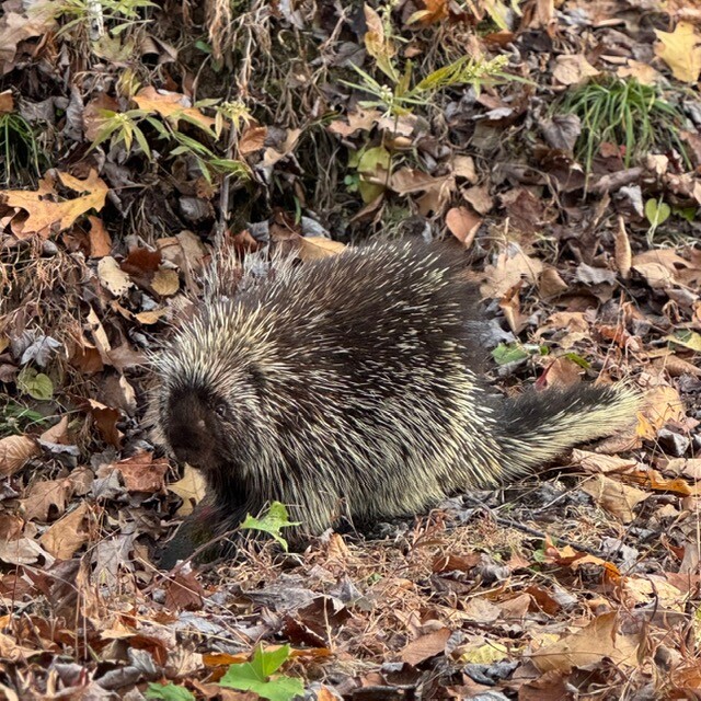
I was starting to pull out my breakfast when I heard a rustling and looked up. I was about 7 feet away from a porcupine! I was hoping to see one on this trip and had high hopes since the only other time I've seen one in the wild was also in PA, not too far from this area. I backed up a bit and got a bunch of photos. It was completely unconcerned that I was there.
The day was shaping up to be a great last day on trail. The easy road walking soon ended with a very steep up, followed by a very steep down. I stopped at the new shelter at Young Woman's Creek. I perused the media in the mailbox where I saw on the flier for the trail system the Circuit Hiker award. I didn't realize this was a thing until only a handful of miles from the end.
After the shelter followed a climb that was quite steep. The climb was so beautiful and felt like I wasn't even on a trail, just straight up a rocky reentrant. It was reminiscent of a path I'd take on an adventure race. I really should learn how to capture the steep grades on camera. Somehow, they always turn out flat looking.
The walking got easier and I cruised through the woods at a pretty fast pace. I put on some happy music to enhance the experience and enjoyed the walk fully. I got to a really cool coniferous hollow which I learned once I exited was called Spook Hollow just before noon. The shelter there was cute and decorated accordingly.
Shortly after, I got the final climb before my descent to my car. It was a long one, but at a grade that I quite enjoy. I kept up my normal pace to the top. Again, the woods were lovely and I began the descent back down, crossing the road and reaching my car at 1345. I signed out at the clipboard, took some final photos and drove on home.
Daily totals
17.13 miles
3565' gain
3930' loss
6:39:55 hours hiking