


Statistics:
Total miles 108
Total vert 19531 feet gain
Total time 2 days 7 hours 26 minutes
Files of proof:
Photo Album: https://photos.app.goo.gl/Wf9LvsqyYbG9JR1L8CoTrex map: Rainbow trail # 1336 https://trails.colorado.gov/trails/rainbow-20055
Spot tracker map: https://maps.findmespot.com/s/89M4/RR#history/assets
Strava Day 1: https://www.strava.com/activities/15544616615 Start time 3:43 am, total time 18:20:09, 50.25 miles (51.75 minus 1.5 extra), elevation gain 7290 feet
Strava Day 2: https://www.strava.com/activities/15557019988 Sart 4:00 am, total time 18:36:57, 40.23 miles (41.43 minus 1.2 extra), elevation gain 8911 feet
Strava Day 3: https://www.strava.com/activities/15561641036 Start 3:52 am, total time 7:17:03, finish time 11:09:03, 17.47 miles, elevation gain 3330 feet
Description: the trail is a good 75% rocky - all kinds of rock, bigger, imbedded, lose, chunky, baby heads, and a lot of fine pulverized dust - this is what you get when traveling on multi-use trail, which is intended for horses, ATV's (under 52") and motorbikes. The only good long stretch is the final 11.5 miles after crossing Hwy 50. There are basically no good views but a few openings in the second half for the mountains, and a number of open vistas on the flat ranches to your right (especially in the first half). Plus, the trail being carved into the side of the slope below the Sangre de Cristo mountains, with no basically no flat spots to set a tent on and only a handful of official "campsites" in the first 30 miles, where there are side trails coming up for hikers. Lastly, there are plenty of creek crossings in the first 50 miles, none of the reroute portion after creek crossing (about 10 mile stretch all the way into Hayden creek), and then no water between 90 and 105 (a few in the last mile). I'm providing this information in case anybody else wants to go for it in any style and needs to plan better. As a side note, the approach to either end - South and North terminis - is pretty bad: winding one lane bumpy unmaintained dirt road for 3 miles at Muddy creek winding between private properties, and 4 miles a very chunky seriously mountain approach 4WD rocky one lane road on the Marshall pass side.
Trail history: it is the OLDEST continuous long trail in US - 1912 (older than AT and PCT, and even Long trail in VT which started in 1912 and finished in 1930)
My connection: I stumbled upon Rainbow trail in the various few hikes over the last 4 years, as connecting pieces to oher trails. My husband Larry, who always digs into information, found out that it is, indeed, a long stretch of a trail, over a 100 mile long. I went on the FKT site and found out that only 2 people completed the trail in supported manner - Cory Linfield in 2014, and Rachel Merling in 2023, plus a report from just regular hikers in 2019 (http://www.catjonesfilms.com/meowza/hiking-the-rainbow-trail). ALL of them talked about the trail being collapsed right in the middle, and having to either scrambling in and out of the wash out (Cory), or taking a detour via vehicles on a dirt road and reconnecting. This summer, I met a gentleman who is a member of Central Colorado Mountain Riders (motorbikes) https://www.facebook.com/centralcoloradomountainriders/, and he told me that his club got a grant a few years ago to add the portion inside the National Forest boundary (the BLM portion has already being done), which they did last year (2024). Per his information, a few riders and one woman on the horse were the only completers of the newly rerouted FULL trail. I decided I should go for it in an unsupported style and piece the GPX together. The man also assured me that CoTrex app has updated its' files to the latest available information, which was true and invaluable - since the GPX file I uploaded onto CalTopo from the FKT, as well as Strava and Coros apps still have old trail route. Besides the reroute in the middle - which added about 4 miles per my trek - there were 2 switchbacks added in the last stretch after Hwy 50, making it 11.5 instead of 10 miles (see Strava files compared between mine and Cody's).
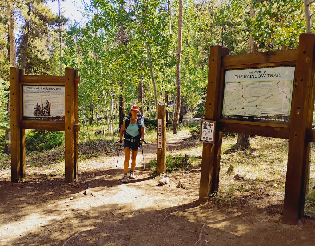
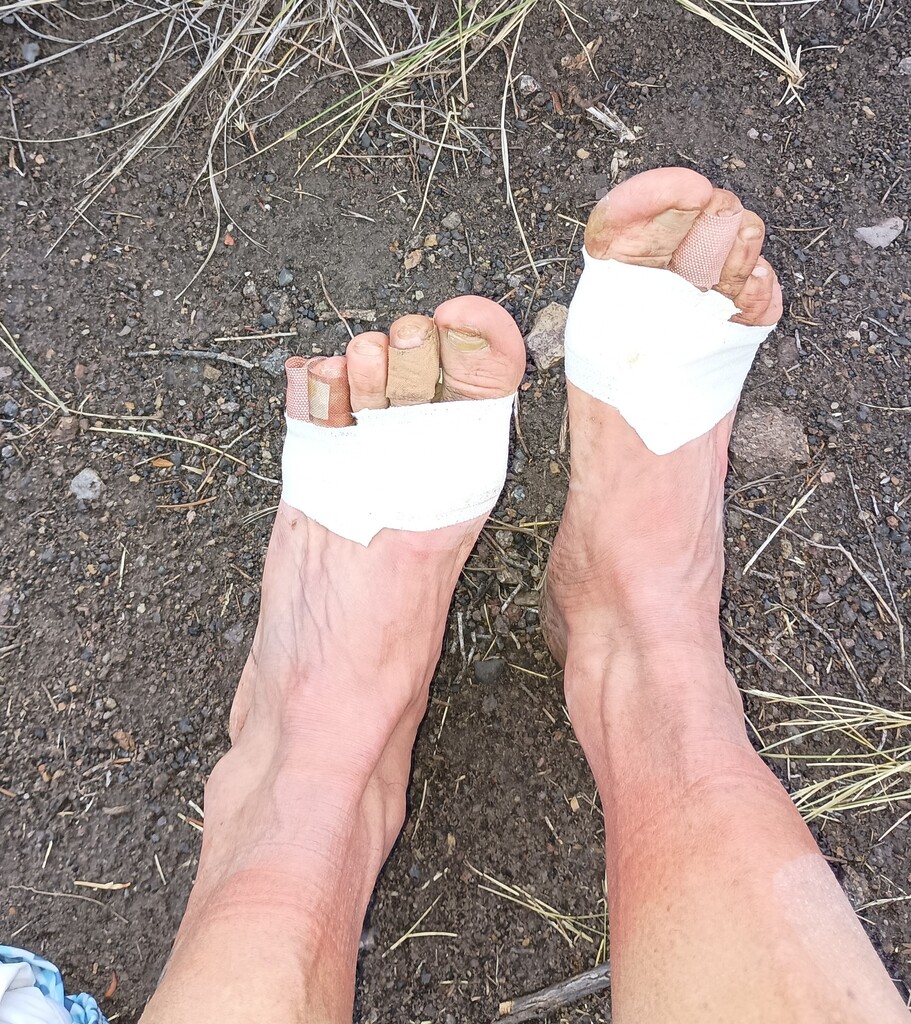
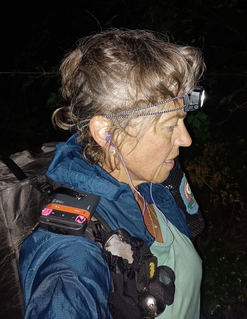
Trip report: I was able to squeeze out 3 days inside my August racing schedule, starting 4 days after the 50K I ran in UT. My husband drove me to the South end on Wednesday night after work, where we set up the camp (which allowed me to keep my backpack intact in the car and an easier morning). I started at 3:43 am on Thursday 8/21/25. At mile 16.5 I realized that I dropped my phone somewhere, and crudgidly had to backtrack - luckily "only" 0.75 miles, making it an extra 1.5 M round trip (trust me, I was staring at my watch). I was clicking 3 miles an hour on the dot for exactly 36 miles, when my feet, that were throbbing since mile 15 on all the rocks, got really bad. At mile 37 I took a break and changed socks. It was a bad realization that I'm looking at ruining them, and it rattled me (I still had a number of races coming up, one being RRR 50M in a mere 3 weeks). I almost bailed, but I already had an emotional breakdown in my (different) long trail FKT attempt(s), and decided to push through. It took a while after I planned to stop for the night to find a tiny flat spot on top of the ridge at mile 50. Second day involved navigating a new detour (again, grateful for CoTrex). The beginning of the detour was the most confusing. At first I was circling for a bit around an old trail being decommissioned and having brush and logs over it, then finally figuring out this is where 2 folks mentioned the trail closure. The new trail was making me cross the creek 3 times in the first quarter mile (it did have wooden signs!). Finally, I hit a dirt road connector, then a long single track of a newly carved out trail inside a burnt area and a new growth. This stretch climbed forever (not steep, just non-stop long for 6 miles and no water), inauspiciously finally clicking into the original Rainbow trail. I specifically kept checking the GPX on CalTopo (from FKT) and CoTrex app against each other (I added 2 snap pics to the album). I took my one break a day at Hayden creek to soak my feet, and then kept going. The whole day involved much slower miles than the first day, likely due to more climbs per distance, accumulated fatigue, and my screaming feet. As the darkness was just setting in, I managed to take a wrong turn off the Rainbow TH at mile 36.5, and make an extremely streep horrible (which I labeled "suicidal stretch") of 0.6M on black dimanod bike trail (Gutz trail). My save was that Larry (my husband) was tracking me closely, and texted me "Are you going down? Wrong way!". I had to climb back up (making another 1.2M extra for the full trip on top of 1.5M in day 1), and navigate a connecting dirt road to the turn-off Rainbow trail, fighting tears in the dark. Another search of the flat spot for my tent took me almost to a dirt road tune-off, where I settled at mile 90 total (40 for the day) under a tree before that intersection. Third day I just had to make "an exit". It started with a steep climb of 1.7M/1300 ft, then a long steep descent to Hwy 50 crossing. That descent was what did my feet in for good. The balls of my feet were on fire, and once I crossed the road, I took my shoes off and sae that 5 toes had burst blisters (don't care for those), and both front of the bottom of my feet had those excruciating deep under-calluses blisters that were also filled up. I poked all of those with a safety pin, wrapped them with a new tape, and turned to Dr. Advil load for the final stretch. Ironically, those 11.5 miles were the best of the whole Rainbow trail - a buttery single track that I could have jogged, yet I was wincing in pain. I did make a good time on this last leg, though, just telling myself I'm almost done. I was getting ticked off that the finish is not coming soon enough (as I mentioned before, the trail added extra 1.5M). Finally, I heard a woop, and my husband, who drove to the North end, was there to greet me, and take me home. I wasn't planning to get emotional, as I mostly felt dumb for not bailing out and destroying my feet in doing the the full trail, but seeing him was such a heart-filled moment, I broke down. He is definitely my hero in supporting all my insane adventures, weather simply agreeing to it, listening about it, driving around, worrying and following the tracker and watching the weather, and giving hugs. Speaking of the weather, it was a hot one (mid-90's), and the forecasted storm for the second day never came. Also have to add, at least during the weekdays, this is THE loneliest trail I've ever stepped on. On the first day I saw 8 people - 4 hikers and 4 cyclists all between miles 20-25 (where the side trails were connecting to Rainbow). On day 2, there were 3 people - 1 hiker at Hayden creek, and 2 motorcyclists at the top of the climb after it. And on the last day, I had 5 cyclists in the final mile. That was it!
Good luck to anyone brave enough to beat up their feet! I am barely walking, and am very concerned about my Fall racing season, but otherwise, completely intact.
Comments
Correct link to photos:
https://photos.app.goo.gl/Wf9LvsqyYbG9JR1L8
Also it's hwy 285, not 50, that you cross before final 11.5 miles on the north end