

26 miles into my first day, I stood, staring up at East Pecos Baldy standing 1100 vertical feet above me. I was exhausted, my back spasmed and twinged in pain, and I was unsure if I could even make it 4 miles back to camp, much less climb this peak. We had already summited 5 peaks that day, doing over 8000 ft of vert, all while loaded down with a 25-pound pack. Overwhelmed by a mix of anxiety and a creeping sense of defeat, I made the tough decision to bail. Each step back to camp, heavy with the day's toll, echoed my internal struggle: had I given up too soon? The darkness around me seemed to mirror my mood as I trudged back into camp. The first day was done and already things weren’t going as planned.
The idea for this project started after learning about the “Rocky Mountain Slam” in 2020 and wondering why that route left out the New Mexico portion of the Rocky Mountains. I’d done plenty of New Mexico peaks and knew we had a lot of remote terrain over 12,000 feet. Doing some research and looking at different lists and websites, I settled on a list of 37 peaks over 12,000 ft in New Mexico, three of which are over 13,000 ft. Since 8 of those peaks are not accessible to all, the final list is of 29 peaks.
Day 1: The NM Highest Peaks started On Saturday Aug 12th, at the Santa Barbara Trailhead. I had camped there overnight, and my friend Brad Higdon joined me at 4:30 am. We quickly sorted out some gear and at 4:45 am we started up the Indian Creek Trail with roughly 25 lb packs. This portion of the northern Pecos Wilderness has a lot of 12 and 13k peaks with very little access so we decided to fastpack, and camp for one night to link a bunch of peaks in one go. The trail was decent up to Jicarita, with some deadfall to keep things interesting. We summited Jicarita around 8 am and descended off the peak towards the south on a nice trail. At the Serpent Lake and East Fork trail intersection we continued south on the ridge on rocky ground without any real trail to follow. A few miles took us to the summit of Trouble Benchmark, a mellow peak that was bathed in clouds. On the way off of Trouble, I took a step in some talus on what appeared to be a large stable block, the next thing I knew I was upside down in a hole in the talus. Thankfully I only sprained some fingers and stubbed my big toe, along with some nice scrapes on my leg. We then descended into a large saddle above treeline, where the east fork trail meets the ridge. A rugged thunderstorm was moving towards us but appeared to be heading north so we climbed up to Santa Barbara Peak, our third peak of the day. The peak was wide, flat, and foggy and it wasn’t very clear where the summit was, so we tagged all of the high points on the north and south of the summit plateau just to make sure.
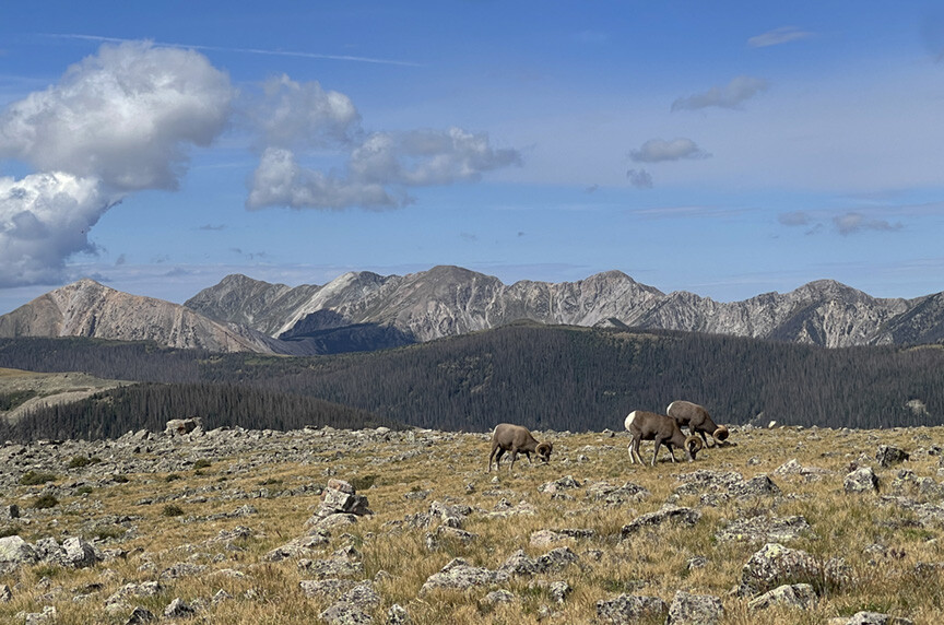
We dropped down into another saddle along the skyline trail now to the intersection with the Middle Fork trail and the Pecos Trail. We then climbed again on a nice trail along a beautiful ridgeline. After another mile or two we split off the trail up to the summit of Barbara Peak, a nice summit in the shadow of Chimayosos Peak. More storms were quickly brewing over the Truchas peaks to our west so we hurried down the ridgeline towards our next peak. Down in the saddle the rain overtook us so we huddled down under some trees and Brad found a nice rock outcropping to hide under. I took this as a chance to eat some food but unfortunately, I was out of water. Once the rain passed we thought we were in the clear and took off up the steep flanks of Chimayosos. Out in the open and above treeline we got hammered by hail that then turned into rain. It didn’t seem like there was lightning so we continued up to the summit. The rain cleared and the sun came out as we got to the top where we were greeted by at least 20 bighorn sheep ewes and their lambs. I wasn’t sure if they were threatened by us and were going to charge or if they were just curious and wanted food. We hung out on the summit for a little while eating and enjoying the view North into Santa Barbara Canyon and the impressive Truchas Peaks to our west. It was one of the most magical summits I’ve experienced, we’d done 19 miles with already 7000 feet of vertical gain.
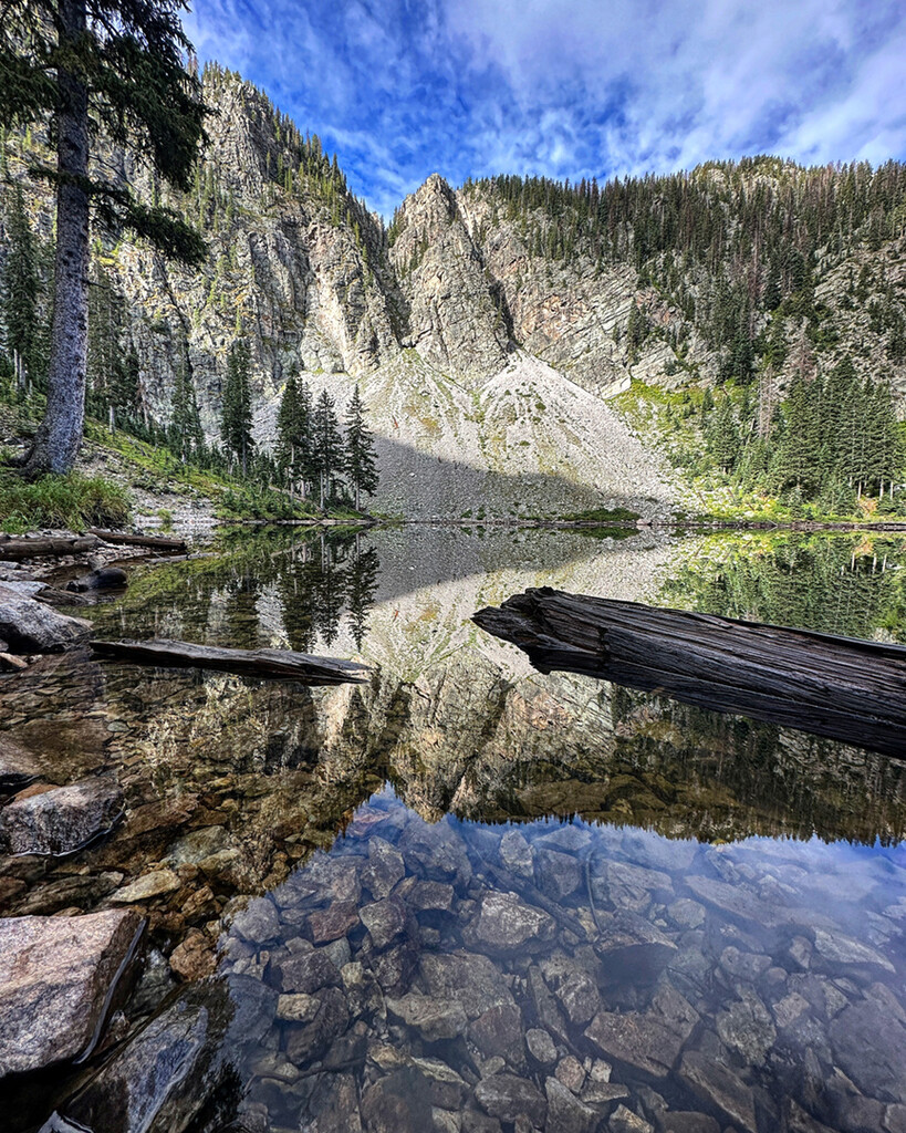
With sun and plenty of wind we dried out as we descended into the saddle where the West Fork Trail climbs out of the canyon to the north of us. We headed south joining the Skyline trail again and heading towards the Truchas lakes. I was finally able to fill up water in a small stream before the lakes, I had a Katadyn water filter bottle that I used for most of my days out, refilling my flasks. The Truchas Lakes have great camping but were pretty busy so we continued south until we found a small flat area among some boulders to set up camp. We brought a fly and footprint plus the poles from a UL Nemo tent, which total weighed about 1.5 lbs. We set up the tent, ate some food and stashed our packs. 22 miles and 5 peaks into the day and we still had one more on our schedule. I stuffed two water bottles and some food in my pockets and we headed south. The trail traverses below South Truchas Peak and climbs up onto the Trailriders Wall, a gorgeous grassy ridgeline that eventually connects with East Pecos Baldy. The trail first descends down to Pecos Baldy lake, and that is where I found myself 26 miles into the day, almost having a panic attack while staring up at the Peak, before bailing. Ultimately, I have thought about that day a lot, and I am happy I turned around and we made it back to camp easily. We did 31 miles the first day with around 8000 feet of vertical gain.
Day2: After slugging down some ibuprofen and enduring a sleepless night, we packed up camp, filled water in a cold stream, and immediately started straight up a steep slope to summit South Truchas Peak, 1700 ft above our camp. South Truchas Peak stands at 13,102 ft and has the largest prominence of all the NM peaks. It was a brutal way to start the day, climbing straight up a 40 degree slope with our packs. We reached the saddle at about 8am, less than an hour after leaving camp, and quickly climbed to the summit of South Truchas Peak. I will say it is the most beautiful and impressive peak in NM with 360 degree views. We cruised back down into the saddle towards the north and took a small detour over to Medio Truchas Peak, or what is sometimes called West Truchas. Even though the West summit is not technically a peak because it lacks prominence, it is a worthy summit. The entire North face of the two middle truchas peaks are massive cliffs, dropping straight off into an alpine cirque.
We headed back to the east and followed the ridge down from Medio Truchas Peak towards North Truchas. You have to zig-zag a bit towards the east on loose talus to stay away from cliffs but route-finding isn’t that difficult. I stuck to the direct ridgeline, scrambling through some fun terrain until we hit the saddle above the Truchas Lakes. Some easy fourth or fifth class scrambling took us up to a steep ridgeline leading to the summit of North Truchas. At this point in the day some heavy clouds had formed rapidly and were starting to move in. We hurried to the northwest following the ridgeline towards Sheepshead but were stopped by some very loose, crumbly cliffs. I found the downclimb but with heavy packs on our backs, tired muscles from two long days, and the rapidly deteriorating weather we decided to abandon our effort to climb Sheepshead. We hurried back up and over North Truchas and dropped into the West Fork Saddle to head back towards our cars at Santa Barbara trailhead. About 30 minutes down the trail we got hammered by a typical New Mexico thunderstorm. Intense rain lasted for over an hour which soaked me through all my layers. This is where I discovered that my lightweight wind jacket couldn’t hold up to actual rain. We just kept moving to try and stay warm and eventually the rain stopped about 5 miles down the trail. I thankfully had a dry shirt in my pack and changed clothes and we finished up the last 5 miles to the cars. We had cokes and snacks at the cars and Brad headed home. I soaked in the cold river, ate a bunch of cookies and headed home myself to rest.
Day 3: Monday, I woke up to heavy cloud cover and rain. Looking at the map it seemed like the lightest part of the storm was to the north, so abandoning my original plans I drove up to the Valle Vidal to climb Little Costilla Peak. I parked on the side of the road just west of the corrals and headed up cross country until I found an old trail along an old fence line. The first mile is steep and then the ridgeline mellows out. It was raining and there was some lightning but it seemed like the lightning wasn’t ground strikes so I pushed through. This ridgeline has the largest stand of bristlecone pines in the US and is quite beautiful. Above tree line the visibility was near zero with clouds and horizontal rain. Even though I had been up there before I had to keep checking the maps on my phone to make sure I stayed on course. I eventually reached the summit after a few false summits and quickly turned around. I was able to run most of the way down and got back to my truck quickly for a total of about 7.5 miles. The weather was still crap so I decided to call it a day. I stopped to fish the Costilla for a bit and ate a ham sandwich that was questionable…….
I rested the rest of the day and tried to plan out the remainder of my week. The forecast for the whole week was bad, rain and thunderstorms everyday through Friday. After an exceptionally dry summer the rain was nice, but it was not looking good for doing all of the peaks in my original timeline.
Day 4: Tuesday morning, I woke early and hit the Bull of the Woods Trailhead at about 5:30 am. It was spitting rain and was very cold. About 2 miles up on the Long Canyon Trail my stomach started to churn and I proceeded to dry heave badly for the next 3 miles or so (weird ham sandwich from the day before….?). I tried eating and drinking different things but finally gave up on fueling and just started to question my sanity and wonder why the hell I was doing this……. I pushed on through the clouds to the Gold Hill ridgeline where the wind got pretty gnarly. On the ridgeline I could see silhouettes of Big Horn Sheep off in the mist and I ended up walking through a whole herd of them right near the summit. After a quick stop I turned around and headed out on the ridgeline towards Lobo Peak. The rain stopped and I even got some sunshine right before summiting peak 12,040’ (or 12060’ depending upon the map). I descended to the Gavilan Saddle and without much thought I threw in the towel and started running down the trail towards the ski valley. Of course, the sun came out and it was a gorgeous day, for a while. On the way down I passed an older gentleman who looked at me and immediately asked “Are you doing all the peaks?” I was a little thrown off as I replied, “Yes, I’m on day 4 of linking all the 12,000 ft peaks.” He got a big smile and told me his story about doing the exact same thing over a long summer many years before. It was an unlikely bit of trail magic as I usually just run past most people with only a quick “hello”. We chatted for a bit about New Mexico and Colorado mountains, about remote 13ers we had both done, and how he was working on completing the Colorado Centennial Peaks. Eventually I took off running again and made quick work of the few miles back to my truck and headed home. I was feeling beat up at this point from lack of fuel and didn’t think I could push up any more peaks, especially with thunderstorms building everywhere.
Day 5: Wednesday, my fifth day, the weather looked pretty good to the north, so I headed up to park at Cabresto Lake to tackle the Latir Group of peaks. It was rainy and cloudy to start but cleared up as I approached the Heart Lake trail Intersection. At this point I headed off trail going due north to the saddle just east of Baldy Cabin Peak. It was a quick easy ridgeline up to the Peak and I then backtracked to the saddle and headed due west along the ridgeline. This seemed shorter than following the trail to Heart Lake. It was steep but did prove to be a shorter and more direct path. The sun was in full force at this point and I cruised over to Latir Peak first and then followed the trail down to Venado and over to Virsylvia. I was feeling pretty good this day and made quick work back up and over from Virsylvia and made it back to the trail heading south. At this point I was out of water and thunderstorm clouds were moving in quickly which gave me a little extra push to run faster on the trail to Costilla peak and then over to Peak 12,456. A steep descent took me down to a saddle and up to the ridgeline that went up to Bull Creek Peak. I was thirsty as hell, so I hurried down towards the Bull Creek trail. The springs that had been flowing nicely early in the summer were all dried up but about a mile down, the stream started flowing again and I finally filled up my water flasks and ate some good food. I ran the rest of the way down to my truck at the lake. I was pretty psyched to have ticked off all of the Latir peaks, 7 in total for the day! I soaked in the cold lake and headed home. This day felt like a big win and really helped to encourage me along on this adventure.
Day 6: Thursday was rainy again, so I headed south to at least get one small peak ticked off. I drove down through Chamisal and up a forest road to the flanks of Truchas Peak. I had summitted Truchas Peak earlier in the Summer via Santa Barbara and had spent hours crawling over and through deadfall, so I was game to try any other route. I followed a GPS I found on Peakbagger which was steep but short and took a steep ridgeline straight up to the summit. It was nice on the summit, intermittent clouds and only a little rain. A quick and uneventful return down my descent got me back to my truck and I headed home.
Day 7: Friday had rain in the forecast again and I knew Saturday was going to be a big day with my buddy Brad Higdon joining me in the Santa Fe area so I took the day off and rested. So far this week I had done twice the mileage and about 4 times the vert of any week in my life yet.
Day 8: Saturday morning I picked up Brad at about 5 am and we headed south to the Santa Fe Ski Area. About 7 am we left the trailhead and headed up the Windsor trail. At the top of the ridge we turned east up the trail to Lake Peak. It was a bit slow going but we hit the ridgetop of Ski Santa Fe and traversed over to Lake Peak. Not knowing that there was a trail I followed the rocky ridgeline direct through some fun easy scrambling that was not at all necessary. We descended the saddle to the east and climbed up Penitente Peak. The trail heading north off the peak and down into Puerto Nambe was wonderful and we ran the whole way down. At the saddle we were already out of water so we took the Windsor trail down about ½ mile to a spring and filled our flasks. We returned up the trail and headed up the switchbacks to Santa Fe Baldy. The trail was nice but I was fatigued and it was pretty slow going up the steep ridge. We tagged the summit and headed north along the ridgeline which would take us to Redonda Peak. Along the way we saw a pack of four of the biggest coyotes I have ever seen in New Mexico…. As time passes I’ll just say it was actually a pack of wolves. The ridgeline was about 2 miles to Redonda Peak and wasn’t hard but without a trail it took longer than I had hoped. We tagged the summit of Redonda finally and stopped for a quick lunch. Back up and over Santa Fe Baldy to the trail and we were finally heading back! We ran back down to the spring, refilled water, and booked it out. At this point I tapped into some reserve of energy and we were able to run the Winsor trail all the way back to the trailhead. 22.5 miles and over 6000 feet of vert made for a good day, the longest leg of the whole adventure. Burgers and large cokes fueled us and we headed home.
Day 12: Unfortunately, I had only been able to take a single week off of work so my plan for one continuous push to summit all the peaks was thrown out. I rested Sunday because I was beat up and the rain was intense. I worked three long days of work and the next Wednesday I left work at 4pm and drove east to the town of Eagle’s Nest to bag one peak that evening. Touch-Me-Not is the one peak on the list that you can drive close to. Wanting to give it a fair effort I parked 3000 feet below the summit on a 4-wheel drive road and headed up the road with my dog Kona as my pacer for the day. I ran a few miles up a forest road where you then you descend off trail into a saddle to find a nice but steep trail up to the summit. It’s a steep rocky stair stepping trail and I hit the summit with beautiful light sifting through the clouds as the sun was getting low in the sky. I booked it down the trail and decided to try my luck on an old logging road to traverse back to the main forest road. A little bit of climbing got me back to the road and I ran the last 3 miles in the dark down the road to my truck. It took just over three hours to do 10.6 miles and 3400 ft vert.
Day 15: Two more long days of work got me to the end of the week and back to finishing up my adventure. Saturday was a rainy and windy day but I headed south anyways to summit Sheepshead. Driving down through El Valle I parked at the San Leonardo lakes trail and headed out. A nice trail takes you up to some amazing lakes in a rocky alpine cirque. From there I headed up an avalanche chute to a saddle southeast of the lakes. I followed the rocky ridgeline through the clouds and got to the final ridge up to Sheepshead Peak. Through the clouds and rain I was able to get glimpses of the Truchas Lakes and North Truchas peak. It was a beautiful day out. I returned back by my same route and slowly made my way back to the trailhead. I went and picked up my partner Malia and we headed to Santa Fe for a big dinner. We then drove up the Pecos River valley to Jack’s Creek trailhead and camped in the campground.
Day 16: On Sunday morning I took off about 6:45 am towards East Pecos Baldy. Time to redeem myself after failing to summit it on the first day of the adventure. The Jacks Creek trail is beautiful and well-traveled, so I was able to run almost the entire way to Pecos Baldy Lake. Staring up towards the peak was not as daunting as before and I cruised up the skyline trail and then up the summit trail. I spent about 10 minutes at the summit just taking in the amazing views on a nice clear day. It was cool to look back north at all the peaks I had already summited. I jogged down from the summit and found a sunny rock to stop at for a moment as I ate a brownie and had an iced coffee (the weight that was well worth carrying!). I ran all the way back down the trail, making really good time where I ran into Malia and Kona a few miles from the trailhead, they had come up to join me on the last bit. We ran and walked a bit and made our way back to the truck. It was a total of about 17 miles for the day, 3800 feet of vert, and took just about 5 hours. I must say, it was the most enjoyable day I had out with easy running and good weather (and the brownie was amazing).
Day 17: Monday morning I had to go to work but I woke up early and headed a few minutes up the ski valley canyon to the Manzanita trailhead to summit Lobo Peak. It was a nice easy day, good weather, and quick travel. I was at work at about 9:30am.
Final Day: At this point I only had 4 peaks left, Wheeler Peak, Sin Nombre, Lake Fork and Vallecitos. They had all been closed for the past week due to religious ceremonies happening on the other side of the ridge at Taos Pueblo. This happens in the end of August and the forest service closes all the trails in that area to provide privacy to Taos Pueblo. I took Tuesday off work for my final day. My friend Grace and her dog Alder joined me, and we started at the Williams Lake trailhead and headed up the easy trail to Wheeler peak and over to Mt. Simpson. Grace turned around at this point to go to work and I took off on the technical ridgeline over to Sin Nombre Peak. The terrain on the ridge is so much fun and so beautiful, but my body was hurting and even pushing hard it took some time. Descending from Sin Nombre takes you through a little bit of technical terrain, but it was much faster and got easier on the final ridgeline to Lake Fork. The Lake Fork summit is one of my favorites to ski from in the spring. After tagging the peak I headed back to the south and descended a different ridge towards Vallecitos Peak. There is a beautiful saddle that you travel through and then the ridgeline up the summit is easy. Along this ridge I got hit with bad nausea though and another episode of dry heaving. I managed to push through to my final summit, my favorite peak in all of New Mexico, Vallecitos Peak. I have stared up at this peak almost everyday of my life living in Taos, and most mornings I drink coffee while watching the sunrise come over Vallecitos from my house. It’s a special Peak and was a fitting one for my final summit. I opted to descend into Arroyo Seco instead of back tracking as this would give me the opportunity to travel a beautiful steep rocky ridgeline and descend through the incredible Canoncito trail. I moved slowly at this point as I was feeling the miles. I had also ran out of water and soon found out I had left half of my food and fuel in my truck that morning. I finally got to the trailhead and my truck at 1:57 PM for an elapsed time of 17 days, 9 hours, and 12 minutes since I had started. In total it was 12 days of effort, 72 hours of moving time to complete 176 miles and 53,639 feet of vertical gain. I should have been able to do it much faster but as all plans go awry, I was glad to just have gotten it done. Part of me was embarrassed by my slow effort and it took me a long time to sit down and write this and submit my FKT. (or an Only Known Time as this is a “new” route, at least on the FKT site. I know many people have done all the peaks but i couldn't find any timed record out there.) Part of me was proud of my work. I’ve never been good at sports, was only ever a benchwarmer on the soccer team, a mediocre climber, and at 6’4” and 195 pounds, I never fit the picture of being an athlete. Through an intense year of working 50 to 60-hour weeks, I found time to train harder than I ever had before and made this adventure a reality. I can’t wait to see what times people put down on this route in the future, and most of all I’m psyched for other people to go experience these New Mexico Mountains whether it’s an FKT or not.
A huge thanks to mountain Ninjas Brad Higdon and Grace Powell for their support out on the trails, and most of all to Malia Reeves for supporting me on this whole adventure and keeping me well fed when I got back home.
Link to full album: https://imgur.com/a/4cBAks0