I set out at 0645 on 9/2/23 to complete the Rainbow Trail starting at the southern terminus and ending at the northern terminus. I was supported along the way by my husband and a few friends. I ran solo for the first half, then picked up pacers for the remaining legs at Hayden Creek, Bear Creek, and Poncha Pass. I encountered an unexpected trail closure around mile 55, but I was able to catch a ride off CR 40 over to Hayden Creek to resume the trail from there. Total, I missed about 4 miles of the trail. I realize this may not qualify me for the true FKT, but I wanted to try just in case!
The trail is overall in pretty good condition, but lots of loose rock made footing trickier for me, especially at night. I utilized Infinit nutrition as my primary fuel throughout the course, and I supplemented with real food at my crews aid stations: Alvarado CG, Duckett Creek, Hayden Creek, Bear Creek, and Poncha Pass. I experienced some pretty painful IT band pain starting around mile 60, so I had some significant slow downs because of that with frequent stretching and some pain relievers to get me through. My feet fared surprisingly well, with only a couple minor blisters creeping up around mile 80 that I was able to address and keep moving. This was my first 100 mile endeavor, and I am really glad I got to do a local route through some beautiful country. Weather or not this will qualify as an official FKT, I have still shared my Strava link in the comments on the route page, because it was hard to find good trail beta for this course as very few people have done a large majority of this trail, and it is typically more of a motorized trail use along the southern half of the trail.
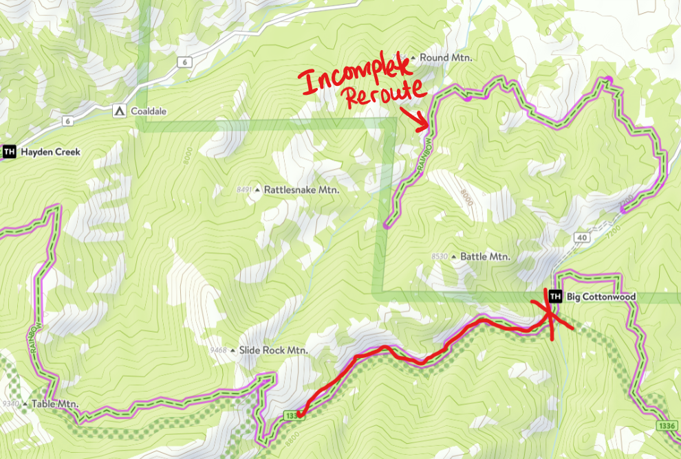
Editor's Note: A portion of the trail was closed, and the reroute is not yet completed. The athlete paused their effort at the dead-end, and picked back up at the next logical starting point. Attached is a screenshot from CO Trex, which has the most updated progress on the new trail reroute off of CR40. The red "X" correlates to mile 54 on her Strava track where she dead ended then backtracked to the road and paused her track at the new reroute (that doesn't connect).She then restarted her garmin tracking at the Hayden Creek TH off CR 6. The new trail reroute is in progress and completed on the BLM property side, but dead ends at the National Forest boundary with no current ETA for completion.