
The Guadalupe Ridge Trail. Trip Report
Prologue: As you may know, I have been one of the strongest proponents on this subreddit for the “stay the f*ck home” policy. As such, during my time in quarantine, I keep reliving what will probably be my last trip for a long while, given the current escalating Covid-19 situation. I hope this trip report brings you joy as you laugh at my dumb ass, and in no way inspires you to “wunderlust” and endanger anybody else’s life or waste finite medical resources.
Where: The Guadalupe Ridge Trail (GRT)
When: March 13th - March 15th
Distance: 66 miles, End-to-End
Conditions: Rain every gosh darn day, low 40’s to mid 60’s
Lighterpack: https://lighterpack.com/r/50hxyw
Useful Pre-Trip information:
Overview.
The Guadalupe Ridge Trail (GRT) is a National Recreation Trail that was established in 2018, and connects Guadalupe Mountains National Park (GUMO) with Carlsbad Caverns National Park (CAVE) through a series of equestrian graded backcountry trails. As a result, there are few trip reports on it, and it’s seldomly hiked. You can find the map of what I initially intended to hike here, as well as what I actually hiked here. More on why I changed my plans later, but as you can see, you can extend the trip up to 100 miles by adding the official Sitting Bull Falls Alternate. The Northern Terminus is “the Big Room” cave system in CAVE. The Southern Terminus is Guadalupe Peak, the tallest mountain in Texas (8749 ft).
Permits.
In order to hike the GRT, you will need two backcountry permits. One for each of the National Parks, and both are free of charge. Backcountry permits for GUMO can typically only be reserved in person and one day in advance. However, GRT permits can be reserved in advance (still in person) if you can present a thorough itinerary to the rangers. Both NPs will allow you to stage your car for the duration of your hike.
Transportation.
There are no taxi services, rideshare apps, or shuttles that work in the area. Unless you have two cars and drivers at your disposal, you will have to hitch unless you know a local. Luckily, the two parks are only 45 minutes apart and people often visit both NPs during their vacations. Hitchhiking culture is nonexistent in these neck of the woods, but I was lucky enough to find a cool group of college kids to take me to CAVE after several hours of looking for a ride.
Water.
All natural water sources are nonexistent in the backcountry, or off limits entirely in order to preserve them for wildlife. However, much of the trail is peppered with water tanks and cattle troughs. The Caltopo I linked has many of the water sources listed. You should be able to plan for at least one reliable water source for each day that you’re out there. If you feel iffy about it, much of the trail is accessible by high clearance vehicles, so you can stealthily cache water if needed.
Day 1; 18.8 miles
After finagling permits from the concerned rangers at their front desks (“You’re going out there...BY YOURSELF?!?!?! You know there’s no water, right?), I began a five mile dirt road walk shrouded in fog and mist. Once that was out of away, a long and steady climb in elevation began.
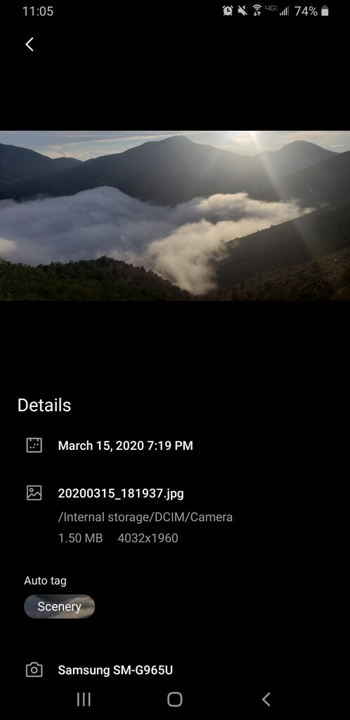
Yet, I was rewarded with beautiful vistas for all my effort. To those of you who haven’t met me yet, I love hiking in the desert. I could see small canyons and hills that extended for as far as I could see. What are even borders, in a place like this? Most of the trail is true to its namesake, and stays along a ridgeline that crests the Guadalupe Ridge.
For an unbeaten path, the trail was easy to follow so far. As the day wore on, the sky got darker and darker. A whisper of thunder hung on the horizon.
“You know there’s no water, right?”
The climb continued as the ridge became quiet...right before a torrent of rain and thunder hit.
Fuck my life.
I quickly deployed my umbrella, and bolted underneath two trees. Usually that’s a big no-no as trees are the tallest objects on a bare mountain, but the lightning seemed to be coming from behind me to the East. I leaned my umbrella into the cold sideways rain.
It was a moderately effective maneuver, and it gave me enough cover to look on Gaia for a decent place to bunker down in. Putnam's Cabin, one mile ahead. After five minutes, there was a slight lull in the storm. I reached for my rain jacket, and moved forward under increased rain pressure.
I climbed for what seemed forever, crossed a small canyon along the ridge, and climbed some more. If I could just make it to the cabin, I’d stop for the day and hunker down for what was sure to be a dreary wet night. Eventually I reached the top of this climb to find the rain beginning to putter out. After a minute or so, it ceased completely and I caught sight of a rainbow off in the distance. But alas, there was no cabin. It had all been a lie, but I was lucky that the rain had stopped for the moment at least.
The time eventually came to take a side trail to Horse Spring, but I was trekking through thickets of trees and couldn’t find the path. Future hikers who wish to take this side trail to Sitting Bull Falls should note that I found a small game trail that led off the Guadalupe Ridge; just look for giant rocks in the trees. Although, I’m not one hundred percent sure this was what I was looking for.
Right when I was about to give up looking for the side trail, the view opened up to my left, and I saw low black clouds rapidly making their way to me. I immediately gave up finding the trail to Horse Spring, and rushed to set up my tarp. I barely made it, and enjoyed my dinner to the splatter of rain kissing dyneema composite fiber.
Day 2; 16.92 miles
“You know there’s no water, right?”
My first thought of the morning was, “f*****ck, my sh*t is all wet.” Mostly just my tarp from rain and condensation, in addition to my sweaty clothes. It was then that I decided that I really didn’t want to take a 30 mile side trip just to go for a swim. I was wet enough, and I really didn’t want to give up the sweet views from the ridge.
I made the right call. The clouds parted early in the day, and I got to see some of the best views of the trip. Previous hikers have stated that the Lincoln National Forest section was the crummiest of the trail, but I’d disagree. I’m a glutton for that classic expansive desolate desert view.
There were also plenty of water tanks and cattle troughs in this section. I found an unmarked tank within the first hour and filled up on rain water. I was running low, so the tank provided me enough water to make it safely into Texas the next day.
I reached Dark Canyon Lookout by 11 AM, and continued after a short break. I took it really casual on this day since I knew I couldn’t legally cross into GUMO and find a place to camp for the night. I hadn’t reserved any campsites this early into the trip, and dispersed camping is not allowed, so I had to cross the length of the park in one go.
After noon, a pack of hunting dogs started to leapfrog me along the trail. As a dog lover, I welcomed the company. Of course, I grew attached too fast, and got misty eyed as they peeled off to do their own thing. Yet one good girl stayed with me for a few more hours.
Eventually I started to get worried that she was unintentionally getting separated from her pack, as she continued to follow me further and further. What if she didn’t make it back to her pack? I couldn’t legally take her into GUMO. Was I gonna have to sneak her in? Would the rangers help find her owner? Would I have to drive her back across the state to my place? Would my dog like her? Is there a no kill shelter along the way? What is your name? Why won’t you drink my water?
I found yet another water tank and trough, brand new in fact, and She finally pulled a long drink. I checked my phone for signal and called my fiance to brainstorm ideas about our newest family member. It was then that I found out how stark the Covid-19 situation had become. The markets were crashing, Spring Break was extended to facilitate social distancing, school was closed for the foreseeable future, more cases of the virus were breaking in our area, and...people were hoarding...toilet paper?
I needed to head home as soon as feasibly possible. In the next moment, a man pulled up in a Polaris full of hunting dogs. “Is this your dog?,” I yelled out.
No it wasn’t, but he did work for the New Mexico Game and Fish Department and was headed towards Dark Canyon Lookout. Of course he was happy to take the dog, the more the merrier! I scratched Her chin, and whispered goodbye. She was clearly unaffected by our afternoon together and merrily sauntered over to the Polaris and jumped right in. She was off to reunite with her true family.
It wasn’t too much further to the state line. The winds began to rustle as I peeked glimpses into Texas’ tallest mountain range. I got into camp way too early, but I took the extra time to dry all my stuff and enjoy the view of one of the best campsites I’ve ever experienced.
Day 3; 30.5 miles
“You know there’s no water, right?”
My first thought on the last morning was, “...are you f*cking kidding me?” Mountain and desert weather can be quite demented, and this morning was no exception. Everything besides my quilt was utterly f*cked with condensation. I couldn’t see more than a few feet in front of me, as I crossed the border into Texas. The fog was a particularly sour point for me, as I had positively looked forward to viewing the far flung Chihuahuan Desert as I descended the Camp Wilderness Ridge.
As I lost 2000 feet in three miles, the fog turned into mist, and then into rain. I had mistaken the dense fog for a cloud back at camp. As I entered the McKitterick Visitors Center area, I made sure to keep my distance from the rangers and pedestrians as I emptied my pack of all unnecessary weight for the upcoming climb. I had no idea how this corona thing worked at the time, I had previously been studying for my exam for a whole week and so largely ignored the news altogether. I played it safe since I was utterly clueless.
McKitterick Canyon was mesmerizing, despite the heavy mist and light rain. The first four miles into the canyon were as flat as a pancake (mmmm.... I could really go for some town food), but the last four were a brutal 2000 foot slog up the canyon wall. I passed the most amount of people during this section of trail, but I streaked passed them as I was unaccustomed to speaking lengthy sentences after three days. Add my Covid-19 misunderstandings, and you get an awkward bearded brown fellow, carrying a sack made of extravagant fabrics and full of cheap plastics, shambling past your family of four as fast as humanly possible.
I didn’t break the clouds or the ridge until 2:30 PM. I was drained, but I still had about twelve miles to go. I put on some Toto, blessed the rains of the GRT, and got to werk. I was honestly in a sh*tty mood. All that work for zero views. Despite my grumpiness, II did try to enjoy the last few hours of the trip. GUMO is significantly underrated, and I encourage anyone willing to make the drive to lose themselves for a few days there.
I made it to my car right around twilight, and beat the rain into Pine Springs. I scampered into clean clothes, set up my quilt inside my car, and ate a box of three day old gas station chicken. Still reading? I was fine, nothing to worry about. Take care, and thanks for stopping by!