I initially planned to make this attempt in March 2023, but there is a 1 mile section of the trail which closes every year from Feb-May to protect nesting falcons. After balancing weather and work/life demands, I was left with only the Dec 8-10 weekend if I wanted this to happen in 2023.
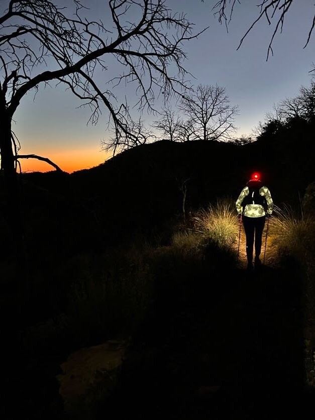
Preparations: I visited the parks 3 times in the last 2 years in order to see sections of the trail which I was unsure about. In the SP, I hiked a few miles from both Chilicote and East Contrabando Trailheads, and confirmed the location of several potential crew access points. In the NP, I hiked the Mesa de Anguila from both sides, seeing all but the middle 10% of this section. I also saw the east side of Chimneys and the rim loop from Chisos Basin. My main regret is that I did not scout the area south of Chilicote down to Madrid House, since this area proved to be very difficult to navigate. While you could argue that going East to West might be faster with it’s net descent, you’ll see that I stuck with the original path starting on the West side. The prospect of seeing hikers on the trail in the final miles and then finishing at a Visitor’s Center (with SNACKS!) instead of finishing in the middle of nowhere, far outweighed that net downhill. I also decided to begin my attempt near sunset, even though this would mean being moderately sleep deprived. I did this for a few reasons: 1) I would have time to secure the necessary permits & passes that morning, since this must be done in person; 2) I would be able to maximize the cooler night temperatures and avoid sun exposure; and primarily 3) this would put me on the Mesa during daylight hours, making navigating this difficult area easier. I set a 30 hour goal for myself, but knew that navigation and lack of sleep would likely mean a longer effort.
Support: I had initially secured a large support team for a March effort, but after having to postpone, I waited to recruit support for my December attempt. My crew of 3 remained unchanged, but I had all new pacers. This was really for the best, since I connected with a couple guys who had seen a good portion of the route on their own FKT attempt(s). Crewing: Herman & Sara Warrington, Andrew Marvin. Pacing: Kenneth Anderlitch (84m), Roel Gonzalez (9m), Andrew Marvin (9m). I only did 6 solo. For their own safety, the crew travelled in 2 vehicles (both 4wd high clearance). They met me at 9 places along the route to provide aid, using 2-way radios to communicate between each other. I carried a Garmin inReach Mini 2 for tracking/messaging, and the crew had a Garmin Messenger for communicating with me when lack of cell service prevented them from monitoring the tracker.
Sections:
- Start to Botella TH: Double track, likely old jeep road, with a minor hills. On fresh legs, it was pretty runnable. I had good energy and was feeling chatty, which Kenneth tolerated well. The crew had to walk ¼ mile to meet us. 10 miles in 1:47, 3 minute break.
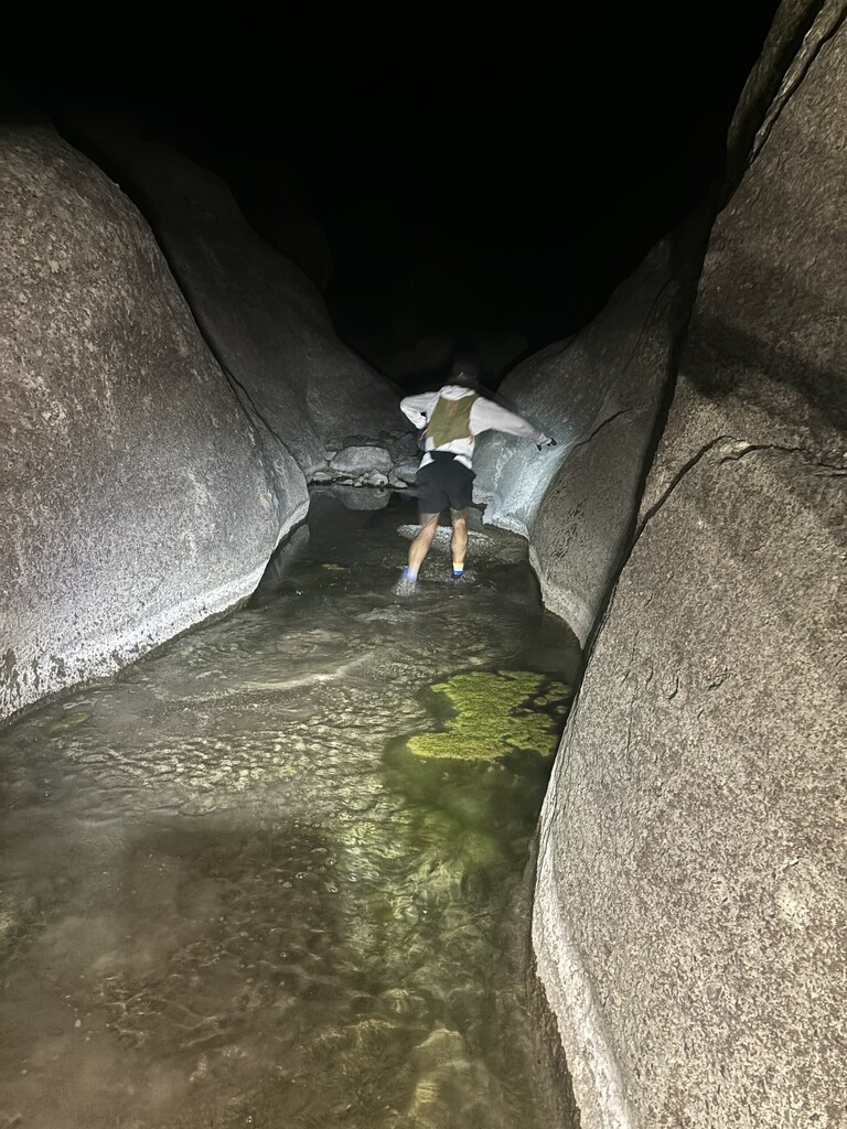
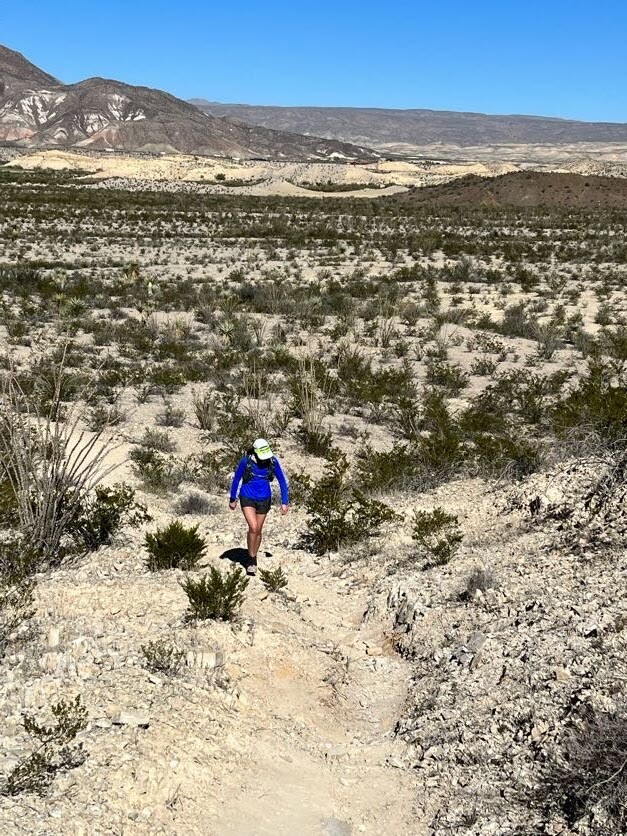
- Botella to Cinco Tinahas: This wasn’t really a trail. The route follows Terneros Creek (a dry wash) then heads SE down more dry wash, finally ending with 1 mile of actual trail. The creek bed was dry but so soft and silty that it was impossible to go fast. Kenneth and I maintained a steady trot as best we could, which often felt like kneading bread underfoot. A few miles in, we got off track on what I believe was Leyva Creek. Consulting Gaia, we determined to continue forward instead of backtracking, as this would eventually re-connect us to the route with only a slight addition of distance. Since we weren’t on designated trail through here anyway, I did not consider it to be a real digression from the course. Unfortunately, the terrain on this section got rather technical in spots and we even had to scramble over boulders a few times to avoid getting the feet wet. We ended up with wet feet anyway before finally getting back on the original route. Arriving at the crew stop, a 10 minute nap in the warm truck was in order, along with a sock change. The crew had also made me a backpacker meal, so I enjoyed some hot butternut squash. 15 miles in 4:15, 41 minute break.
- CT to Puerta Chilicote: Kenneth decided to take an extended rest, so I did this easy section alone. It was all on dirt road, relatively flat and easy to run. Somehow I did manage to briefly go down a side road in the dark, but quickly realized my mistake and backtracked to the main road. I stopped once to turn off the headlight and do some stargazing. 1 minute wasn’t going to hurt anything. I arrived at the next TH for another 10 minute nap and some serious refueling. Also, this is the only TH on the entire route with a vault toilet. 6.5 miles in 1:25, 40 minute break.
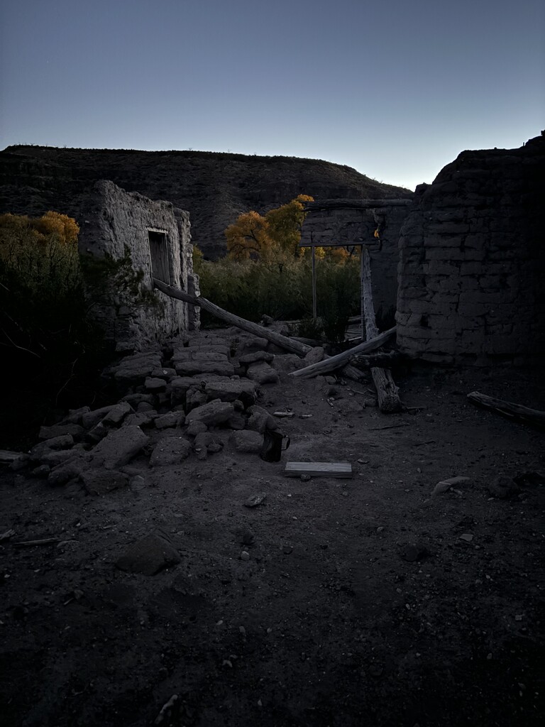
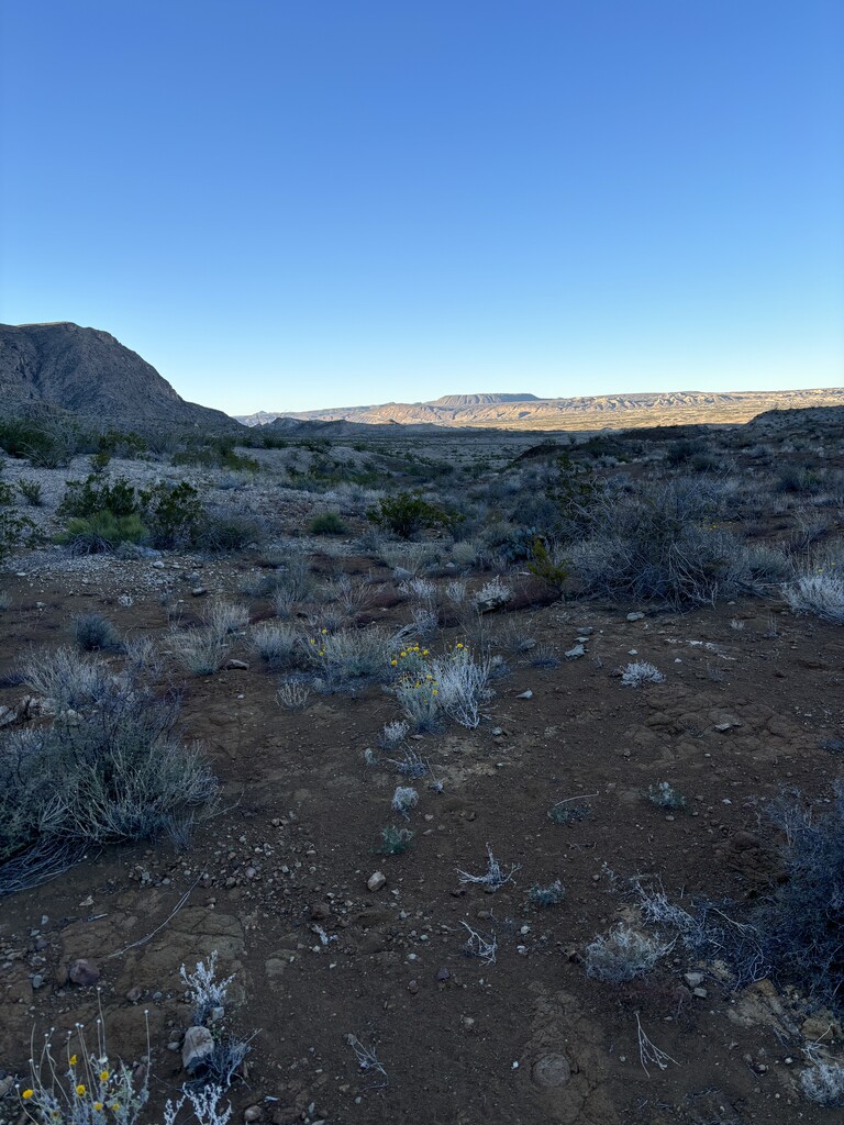
- PC to East Contrabando: Oh the terrors! Going in, I knew it might be difficult to stay on route in the first 5-8 miles, but the rest should be easier. Cairns here were small and far apart. In the dark they were practically impossible to find. In some places a faint path could be discerned and we’d get to run a few yards before having to stop and assess our location. Kenneth had rejoined me for pacing duty, thankfully. We both had the route loaded to our watches, and I also had Gaia on my phone, with the GPX from several past FKT’ers loaded. This was often our best means of finding the way forward. At one point there was a squiggle with one GPX; in the dark we were blind to our broader surroundings and moved forward, slightly right of the path; our location kept getting higher as the elevation to our left dropped off gradually and we eventually found ourselves on a bit of an outcropping. After looking around, Kenneth convinced me to scramble down to the right, which further away from the route but we were able to reconnect once we got down. I remember shortly after this sending a message via inReach to the crew that we’d only gone 7.5 miles in 3 hours. We made a small detour to catch a shot of the Madrid House in the dawn, then almost immediately encountered a fallen tree in the path. This thing and the mess it’d created was impossible. We went right, we went back, there was no going left, we went right again, then forced our way through the cracking limbs and ivy to the other side, only to discover after that we could have just shimmy’ed under the big trunk; from the other side this hadn’t been so obvious. From here the trail finally got better. We were soon on old jeep. This section was the first time where I started getting that sleep-walking feeling. I struggled to maintain a reasonable pace, getting frustrated feeling like I should be running this better. Reaching the East Contrabando TH right off of FM 170 was such a relief! The crew met us there with encouragement and high energy. Since it was only another 1.8 mile road run to the Mesa TH, I decided to make this stop super quick so I could rest at the Mesa TH away from the highway traffic. My crew fetched me a sandwich from a nearby convenient store and I took a long nap. On a side note, my plans had included an optional crew stop at Madrid Falls TH but when talking to the park staff to get our passes, they strongly advised against this on account of it being dark; boulders and $1200 recovery charges were also mentioned. We had 2 capable vehicles but no one had ever driven that road, and seeing us at Madrid would have required the crew to split up since it’s a 3 hour drive around to FM170. 15.4 miles on paper (22.6 on my watch) in 6:35, 1 hr 32 min break.
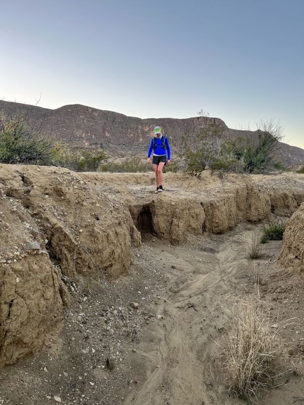
- Mesa de Anguila: Doing this section in daylight was my primary motivation for starting at 7pm the night before. If only I’d know the prior section would be so hard, I may have adjusted to an early morning start instead. Kenneth was eager to see the Mesa, so I got to keep my pacer. We followed the signs and cairns across the Lajitas Golf Course then out and up. This trail is no longer printed on some maps, but it’s still marked reasonably well so that Gaia wasn’t needed much. If it had been dark I think the story might have been different, especially since the trail became more faint once we turned northward. Crossing this northbound section became monotonous for me and I really struggled in the heat. At one point we were able to find some shade and we stopped for about 10 minutes so I could cool down. Kenneth kindly helped me stretch the legs. We eventually reached the Mesa’s ridge on the north side and followed the cairns to stay on the path down. I know there’s a lot of conflicting information about descending from the Mesa, so I want to emphasize that no rope or technical mountain gear is needed for this descent! I may have put a hand on a rock for stability, but it’s very hike-able. I think the fact that this trail T’s off to the south and hits the top of Santa Elena canyon is why there is confusion in some circles (namely Facebook Groups). Soon after getting to the bottom, what’s left of the Mesa trail actually turns more north and heads out of the park. The route, however, goes southeasterly. Having seen this area before, I knew to just keep an eye on my watch map and keep us heading in the correct general direction. The terrain varies out here and in some sections is an interesting soft pillowy dirt surface. Eventually we came to the dry wash that we would follow for the rest of the way to our next stop at Terlingua Abajo. A couple notable things along this stretch include a small pouroff which is easy enough to shimmy down, and a grassy patch which in training was thick chest high grasses for about a football field; fortunately for this trip we just had a lot of annoying dead patches to navigate over. Right before reaching the campgrounds, the route crosses Terlingua Creek, which has had water flowing both times I’ve been there. Immediately before reaching the creek, the dry wash becomes muddy – and I mean suck you down knee-deep muddy. We came up to this quicker than I expected, and since it was now dusk I promptly found myself in the middle of the very muck I’d been talking about being careful to avoid all week! Kenneth convinced me to rinse my shoes in the creek, then we followed the brush line around to a shallow section where we could cross the creek without hitting the deep part. Well, I saw the shallow water and wanted to rinse my shoes again. But here the creek-bed was all sand and mud at the bottom. Two steps and I was instantly in muck over my knees having to suck myself back out; I nearly lost the shoes. I hit a real low here and got angry with the whole situation, but my fabulous crew got me over to the cars, rinsed me off, dry socks, and put to sleep in the warm truck. 17 miles on paper (18.4 on watch) in 6:39, 2 hr 19 min rest break.
- Old Maverick Road: After some hot food and a nap where I legit passed out, I was still sleepy, but feeling optimistic knowing the worst was behind me. Kenneth was resting up for the final section, so Andrew jumped in to pull me up the Old Maverick Rd to the Chimneys TH. This was an easy non-technical section but slightly uphill the entire way. We also had a fierce cold front blowing in. Andrew tried to stay well ahead of me so I wouldn’t be in his dust cloud, but it made me feel disconnected and I kept losing motivation in the dark, finding any and every possible reason to stop or walk. After what seemed like an eternity, we reached the crew for a quick re-fueling. 5.5 miles in 1:15, short break which I failed to note.
- Chimneys Trail: Roel jumped in for pacing duty here. We had turned slightly out of the wind, but the gradual uphill continued as we approached the Chisos Basin. Roel has lots of experience on the route and hopes to make an FKT attempt next year, but he’d never actually met me prior to this weekend. I felt extra pressure to keep myself together in front of this guy who had driven halfway across the state to help someone he barely knew. He was a good companion and it gave me a little chuckle at one point when he did a little parkour move on a rock sitting near the trail; something much needed as I started getting that sleepwalking feeling again. The wind was still pretty fierce, but when we got next to the Chimneys they were blocking it a little so I laid down for a 2 minute trail nap. It was enough to get me to the next TH. In spite of my fatigue at what was now 1am on night two, I wanted to keep this stop short and sweet, but I still took a 12 minute nap. 8 miles in 2:21, 30 minute break.
- Chimneys to Blue Creek TH: This was all on paved asphalt to connect the 2 trailheads, but was steeper than the last 14 miles. Andrew resumed pacing duty here, and was alert enough to keep watch on my safety on the road, since I was too tired to care. It was 2 in the morning so thankfully the only vehicles we saw were those of our crew. I will note that had this been daytime, traffic would have presented a hazard. Cars regularly go 55 mph, there is no shoulder, blind corners, and frequently a guardrail, thick brush, or a dropoff preventing a quick exit from the pavement. Andrew also saw some a few sets of eyes watching us at one point. It’s amazing how effective fatigue can be in removing all fear from the mind. As planned, I took a longer break when we reached the TH down to Homer Wilson Ranch and the Blue Creek Trail, getting a solid 30 minute nap and hot food. 4.5 miles in 1:37, with a 1 hr 13 minute break.
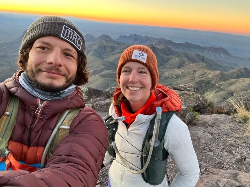
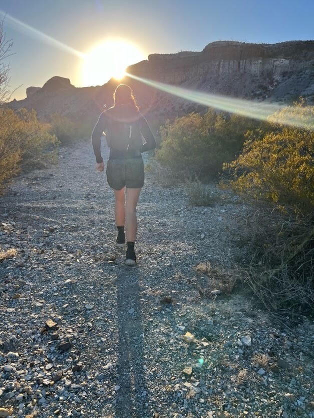
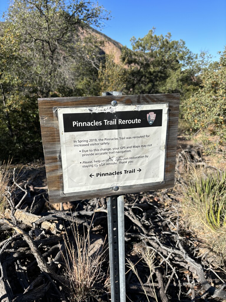
- BC to Finish: Kenneth had been resting up so he was fresh and ready to get me through the final stretch. Honestly I still don’t know how he did 85 miles of this with me; I’m so fortunate to have had the support of such an outstanding athlete. I tried to minimize the warm layers, mindful that the sun would be coming up soon. I had never been on Blue Creek Trail, but expected that it’d be solid dirt singletrack, given what I’d seen of the Rim trails and knowing it was a steep ascent, but I should have paid more attention to the actual trail name! We ascended for 5 miles in a dry river bed. There was no running here, just trudging through the loose rock surface. I started coming unglued toward the end but Kenneth was confident and steady, calming me down. Finally, we reached the Laguna Meadow Trail. Having just run the 16 mile rim loop in October, the rest of the route was familiar territory, and it boosted my spirits to be back on it. The sun was coming up, which also elevated my mood. As we progressed around the rim and then down Pinnacles Trail to the finish, it was nice to finally see other people on the trail for the first time all weekend. The last 4 miles are downhill so we were able to run most of it. In spite of my tired legs, bouncing down the trail and hitting all the steps was a fun challenge that woke me up and kept me engaged. In the last half mile, I’d like to point out that the park has altered the path of the trail. I’ve included a picture of the sign at this point for reference. It only adds about 0.25 miles to the original route. Finishing was as sweet as I’d hoped, and I enjoyed a candy bar and coffee from the Chisos Visitor Center. 15.5 miles in 6:13.
I’ve never done this long a distance and instantly knew that I wanted to do it again someday, but there’s something truly magical about the Big Bend region. This route is definitely not the kind of thing that can be done on a whim. Heck, it’s not really even a trail. It takes careful planning, even when done supported as I have. I hope this super long report can offer some useful guidance, and inspire future successful attempts!