North East 115 speed effort trip report
The training (if you can call it that)
I went into this project in a condition that I definitely thought was severely undertrained. I had been doing my normal training hill repeats, these though were unweighted though because I would not need to be carrying a pack more than a vest for any of the effort. I was not doing these training sessions nearly as often as I should have been though. I got over to the white mountains for a few days with friends, did a presidential traverse that felt really good, and three weeks before the speed attempt I did a week full of inclined treadmill time. This consisted of 10k vertical gain everyday for an entire week, almost entirely on a treadmill due to the heat wave we were currently in. I found myself putting time into other aspects of my life and not having the time for training, motivation also just wasn’t entirely there this year for whatever reason. I took an entire week and a half off from any real exercise before the speed attempt. I figured that if I wasn’t going into this well trained I should at least go into it fresh and well rested.
The general route
For efficiency I wanted to either start in the Catskills or in Baxter State Park and work my way from there. There was a large portion of driving between Baxter and the next mountains and also from the Catskills and the Adirondacks. I didn’t want to do either of those drives twice. I ended up starting in Baxter so that I would not need to have perfect timing at the tail end of the effort to make a reservation at the park. To me the only logical order was to start in Baxter, work my way through Maine, then New Hampshire, then Vermont, then the Adirondacks, then finally the Catskills. I had what I thought to be as close to perfect of a route planned out that I could have for what each and every day would entail and in what order (shout out to Scott Benerofe for helping me come up with and tweak this route). This plan did change some throughout the effort as the weather forecast would come out and change. There were some days that were more conducive to doing in the rain than others, so I juggled things around a bit and added a bit of drive time, but in the grand scheme of things that didn’t make my elapsed time any longer really, it just made some days a bit longer than they would have been otherwise, but I wouldn’t change this at all. Plans need to be flexible, and weather is a really important factor that cannot be planned for. When the effort is this long you need to assume you’ll have some bad weather days, and just hope you have more good weather days.
The format
I planned and succeeded in doing this effort in a self supported manner as defined by the rules on the fastest known time website. For this type of route a car is allowed for driving between peaks. I am allowed to resupply as long as I do it myself. I can accept aid from strangers, but not from anyone providing it specifically for me. I cannot line up to have anyone pace me. What I think sums it up pretty good is I was not able to receive support that would not be available to everyone.
“Housing”
For the duration of the effort I was living out of my 2012 Toyota Corolla. This was not my first time using the ol’ Corolla camper, and I thoroughly enjoy sleeping in it. I have removed the back seats and replaced them with a twin bed that I sleep very soundly in. Some nights definitely started off too hot, but a small fan makes a world of difference.
Food
Before the trip started I bought in bulk the majority of my food to avoid having to stop to buy groceries along the way
Breakfasts- Oats and chia seeds which I would soak each night then add maple syrup to in the morning. Originally this also involved craisins and walnuts, but I wasn’t easily able to force that all down in the morning, and once I removed those from the equation I thoroughly enjoyed my breakfast. I think it helped that by removing those ingredients I made room in the breakfast container for more maple syrup.
Lunch- the plan was to do cold soaked couscous and tuna for lunch. This did not last long. I found on trail I’d much rather drink my precious water rather than use it in food. For lunches I would usually just snack if I was on trail for lunch time, but when back at the car for lunch time I would eat a can of Campbells chunky soup with tortillas ripped up and tossed in for added calories.
Snacks- Welch’s fruit snacks (of course), nature valley sweet and savory granola bars, beef jerkey, m&m’s, tomato basil wheat thins, single serving applesauces,
Dinner- The same soups that I mentioned in the lunch section. My favorite was the chili mac. The chunky soups have good amounts of protein in them and I thoroughly enjoyed them for the entire 20 days. I ate these when I was doing the 14ers a few years ago and enjoyed them then too for the 37 days that project took. In my mind the biggest drawback to these canned soups is the sodium, and boy did I need as much salt as I could get. Many days my shirt would be covered in visible salt.
Liquid enhancers-
I used a mix of Skratch and Mortal Hydration for electrolytes. The Skratch was in a multi serving bag and was good for when I was refueling in the car. The Mortal Hydration was in individual serving pouches and were better used on trail. These were life savers on this effort with how hot and humid it was.
I also used protein powder just mixed with water each night.
For water I had a 6 gallon jug, two gallon jugs, two camel backs, two smart water bottles, and another small bottle just for good measure. I was pretty easily able to find places to fill these when needed. Once near the end I opted to buy an extra gallon of water instead of find a place to fill up.
Occasionally I would stop at a gas station and grab a piece or two of gas station pizza and a milkshake or smoothie.
Notice about stats
All distances throughout this trip report will be estimates from Gaia or Alltrails as I recorded each hike in UltraTrac mode on my watch because of its battery which in this stage of its life leaves a lot to be desired, and the distances it gives in UltraTrac mode are far from accurate. From what I can tell though, elevation gain is tracked pretty well in UltraTrac mode, so for that I will give my recorded amount of elevation gain. Drive times will be estimates taken from Google Maps
Maine
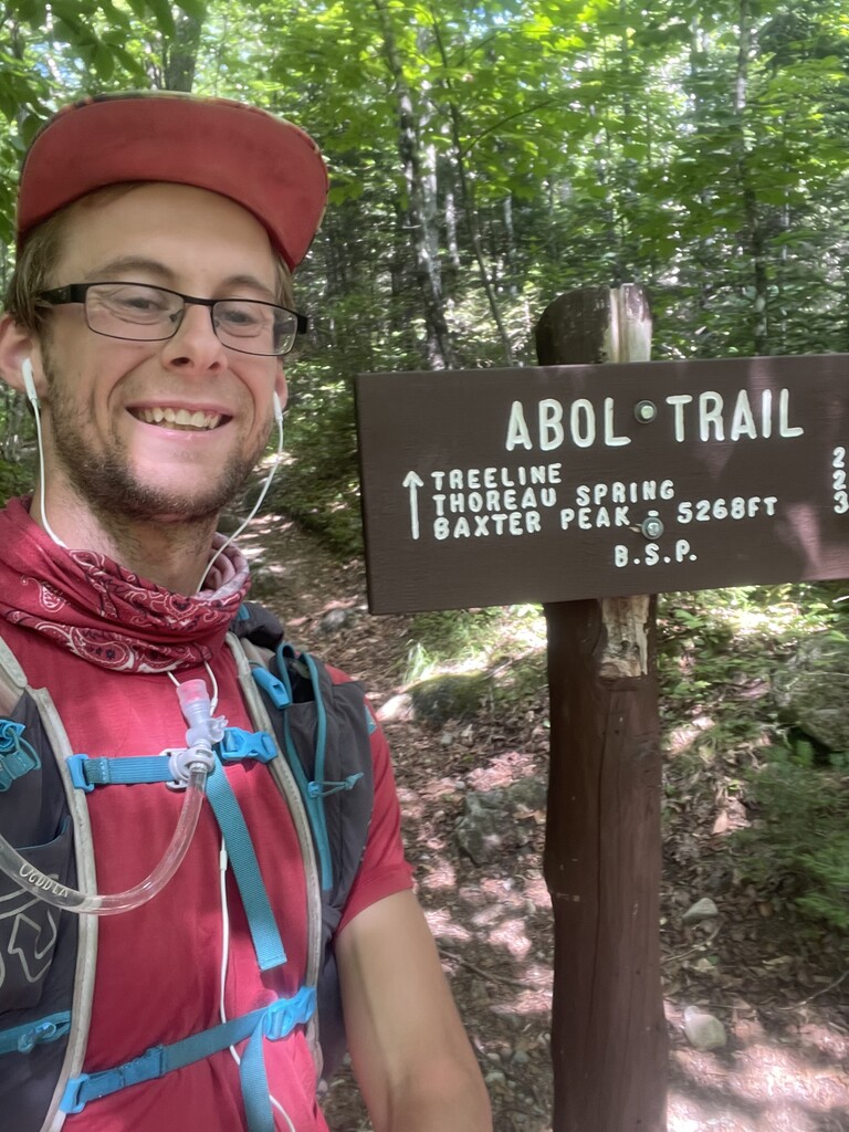
As mentioned before I started in Baxter State Park. I arrived July 6th, one day before my start time so that I was not doing the drive on the same day as my start. I did the majority of my drive on the 6th and car camped in millinocket that night. I found beach area to hangout for until it was time for me to head up to the park for my afternoon start. I had planned for a 3pm start time on July 7th to then give me until 3pm on my last day (which in theory if all went well would be the 27th) to come in under the 20 days elapsed time that was my goal from the very beginning. On paper it seemed possible, but you can make a lot seem possible in theory, when in reality a lot can go wrong. I had a few days reserved in Baxter just in case weather did not line up in my favor for Baxter and Hamlin which are both much preferred to do in good weather due to how much time is spent above tree-line. Thankfully weather worked out for me my first day in the park and I started on the 7th at 3pm as planned.
Weather in Maine was good other than the heat and humidity. That started off strong. Electrolytes were my friend and I was very thankful for the cover of trees and that it’s always a bit cooler higher up.
Overall, Maine went flawlessly.
July 7th
Total daily stats:
Miles hiked- 12.6
Feet of elevation gain- 4,770
Time on trail that day- 4 hours 40 minutes
Baxter and Hamlin
Start time 3pm
12.6 miles
4,770 feet of gain
4 hours 40 minutes
July 8th
Total daily stats:
Miles hiked- 17
Feet of elevation gain- 6,416
Time on trail that day- 7 hours 36 minutes
Drove 34 minutes to the Marston Trailhead.
North Brother
Start time 5:56am
8.1 miles
3,066 feet of gain
3 hours 28 minutes
Drove 4 hours and 11 minutes to the trail for the Bigelows.
Avery and Bigelow
Start time 2:00pm
8.9 miles
3,350 feet of gain
4 hours and 8 minutes
Drove an hour and 24 minutes to the next trailhead and nearly ripped off my exhaust on the final road to the trailhead.
July 9th
Total daily stats:
Miles hiked- 23
Feet of elevation gain- 6,821
Time on trail that day- 9 hours 10 minutes
Crocker, south Crocker, Reddington, Abraham, Spaulding, and sugarloaf
Start time 5:28am
23 miles
6,821 feet of gain
9 hours 10 minutes
Drove an hour to saddleback.
July 10th
Total daily stats:
Miles hiked- 22
Feet of elevation gain- 8,488
Time on trail that day- 9 hours 19 minutes
Saddleback and The Horn
Start time 5:22am
6.3 miles
2,874 feet of gain
2 hours 36 minutes
Drove an hour and 28 minutes to old speck trailhead.
Old Speck
Start time 9:46am
6.5 miles
2,792 feet of gain
2 hours 56 minutes
Drove an hour and 8 minutes to the Bunnell notch trailhead.
New Hampshire
New Hampshire starts here, midway through July 10th. I was looking forward to New Hampshire because arguably it was the area that I knew the best.
Weather through this section continued with the high heat and humidity again which would eventually fade away for some more normal temperatures and humidity levels. In New Hampshire I ran into some rain that would lead to changing my initial plans, but honestly it would have been unrealistic not to expect there to be changes to the initial plan.
Cabot
Start time 2:39pm
9.2 miles
2,822 feet of gain
3 hours 47 minutes
Drove 53 minutes to the Starr King trailhead.
July 11th
Total daily stats:
Miles hiked- 21.8
Feet of elevation gain- 9,380
Time on trail that day- 10 hours 34 minutes
Waumbek
Start time 5:25am
7.1 miles
2,641 feet of gain
3 hours 4 minutes
Drove 42 minutes to Lafayette Place.
North Kinsman, South Kinsman, and Cannon
Start time 9:18am
10.5 miles
4,603 feet of gain
5 hours 40 minutes
Drove 35 minutes to Hale Brook Trailhead.
Hale
Start time 3:54pm
4.2 miles
2,136 feet of gain
1 hour 50 minutes
Drove 45 minutes to Stony Brook Trailhead to drop off my bike and then drove 13 minutes to the Wildcat Ski resort. (I accidentally did this bike drop backwards and had an uphill bike ride at the end of my hike which was not ideal since I am not a strong biker).
July 12th
Total daily stats:
Miles hiked- 27.5 miles
Feet of elevation gain- 9,901
Time on trail that day- 12 hours 9 minutes
Wildcat A, Wildcat D, Carter, Carter Dome, Middle Carter, Moriah
Start time 4:25am
17.6 miles
6,440 feet of gain
8 hours and 6 minutes
Biked back to car then drove 36 minutes to the highland center. Locked up my bike around here for the next time I would need it after my presi traverse later.
Willey, Tom, field
Start time 2:42pm
9.9 miles
3,461 feet of gain
4 hours 3 minutes
Drove 49 minutes to the Hancock overlook.
July 13th
Total daily stats:
Miles hiked- 21.3
Feet of elevation gain- 7,828
Time on trail that day- 9 hours
Hancock and south Hancock
Start time 5:22am
9.6 miles
2,654 feet of gain
3 hours 43 minutes
Drove down the road to Greeley Ponds.
Osceola and East Osceola
9:18am
6.8 miles
3,035 feet of gain
3 hours 23 minutes
Drove 43 minutes to Waterville Valley Resort.
Tecumseh
1:44pm
4.9 miles
2,139 feet of gain
1 hour 54 minutes
Drove an hour and 13 minutes to Appalachia trailhead.
July 14th
Total daily stats:
Miles hiked- 19.7
Feet of elevation gain- 8,553
Time on trail that day- 9 hours 11 minutes
Madison, Adams, Jefferson, Washington, Monroe, Eisenhower, Pierce, Jackson
Start time 5:27am
19.7 miles
8,543 feet of gain
9 hours 11 minutes
Grabbed my bike and started my way back to my car. Got a flat bike tire about halfway through the bike ride. Quickly double checked the rules and confirmed that hitchhiking was allowed for self supported efforts such as this. I then hitched back to my car, returned for my bike, and drove 30 minutes to Rocky Branch trailhead.
July 15th
Total daily stats:
Miles hiked- 27.4
Feet of elevation gain- 7,103
Time on trail that day- 10 hours 11 minutes
Isolation
Start time 5:23am
13.3 miles
3,396 feet of gain
5 hours 8 minutes
Drove 25 minutes to Sawyer River Road parking for Carrigain’s winter lot. The road to the regular lot was closed due to road damage.
Carrigain
Start time 11:10am
14.1 miles
3,707 feet of gain
5 hours 3 minutes
Drove an hour and 8 minutes to the Moosilauke Ravine Lodge.
July 16th
Total daily stats:
Miles hiked- 22.5
Feet of elevation gain- 7,655
Time on trail that day- 9 hours 44 minutes
Moosilauke
Start time 5:21am
7.1 miles
2,425 feet of gain
2 hours 56 minutes
Drove 47 minutes to Pine Bend trailhead to lock up my bike then drove 5 minutes to Olivarian Brook trailhead.
Passaconway, Whiteface, Middle Tripyramid, North Tripyramid
Start time 10:05am
15.4 miles
5,230 feet of gain
6 hours 48 minutes
Biked back to my car and then drove 29 minutes to the price chopper in Lincoln where I spent the night.
July 17th
Total daily stats:
Miles hiked- 37
Feet of elevation gain- 11,286
Time on trail that day- 14 hours 56 minutes
Drove 8 minutes to Lincoln woods.
Flume, Liberty, Lincoln, Lafayette, Garfield, Galehead, South Twin, North Twin, Zealand, West Bond, Mount Bond, Bond Cliff
Start time 4:13am
37 miles
11,286 feet of gain
14 hours 56 minutes
Drove 8 minutes back to price chopper for the night.
July 18th
Total daily stats:
Miles hiked- 15.6
Feet of elevation gain- 3,045
Time on trail that day- 5 hours 39 minutes
Drove 8 minutes back to Lincoln woods. Today was considered my rest day after the extended pemi which historically has taken a lot out of me and left me not able to hike much the next day.
Owls Head
Start time 7:05am
15.6 miles
3,045 feet of gain
5 hours 39 minutes
Drove 12 minutes to the notch hostel for a shower, the first of the trip so far, and MUCH needed. Before this I had jumped into a murky lake after Willey, Tom, Field, but that’s not nearly the same as a shower!
Drove 2 hours 11 minutes to just shy of Underhill State Park.
Vermont
Vermont only took a day. I had been wanting to do the Vermont 5 in a day for a while now, so it was fun to be able to cross that off my list along the way on this effort. I lucked out with good weather this day. Mostly socked in summits, but no rain and reasonable temperatures.
Mid day on this day my friend Jo messaged me saying she thought I was on pace to set the self supported FKT for the New England 67. Up until then I was not aware of this. I did end up shaving ~15 hours off of the previous time.
July 19th
Total daily stats:
Miles hiked- 21.9
Feet of elevation gain- 9,750
Time on trail that day- 8 hours 27 minutes
Drove 7 minutes to underhill state park
Mansfield
Start time 5:24am
4.1 miles
2,516 feet of gain
2 hours 5 minutes
Drove 52 minutes to the Burrows trailhead.
Camels Hump
Start time 8:29am
4.5 miles
2,201 feet of gain
1 hour 50 minutes
Drove 40 minutes to sugarbush and dropped my bike before driving 11 minutes to Mount Ellen.
Ellen and Abraham
Start time 11:33am
9.2 miles
3,379 feet of gain
3 hours 14 minutes
Biked back to my car then drove an hour and 10 minutes to Killington Resort.
Killington
Start time 4:35pm
4.1 miles
1,654 feet of gain
1 hour 23 minutes
Drove 2 hours 34 minutes to the south Meadows trailhead to sleep for the night.
New York
New York…. This was by far the hardest part of the effort. I’m not sure how much of that was because I was nearing the end and my body might have been a bit fatigued by then, but the days out there were LONG. Big elevation gain days and rough terrain made for long days. Each day though I woke up rested up enough to continue on for one more day. In the Adirondacks it was always all I could do to get through the next day. I’m always surprised by what a nights rest can do. I can go to bed exhausted and sore, but wake up feeling pretty decent and do another huge day. I never once WANTED to get up and out of bed in the Adirondacks though. Weather wasn’t too bad, a bit of rain, but not as much as was forecasted. One thing that made this entire effort so hard was the ease at which I could quit. When I thru hiked the North East 115 last summer it would have taken some coordination to get off trail if I wanted to quit. With this challenge I woke up in my car every morning and could have easily driven home. At one point in Vermont I was less than 10 miles from my apartment. It would have been so easy to quit, but each day I had to make the decision to push on.
July 20th
Total daily stats:
Miles hiked- 27.5
Feet of elevation gain- 12,119
Time on trail that day- 15 hours 46 minutes
Drove 2 minutes to the Adirondack Loj.
Tabletop, Phelps, Colden, Cliff, Redfield, Marshall, Iroquois, Algonquin, Wright
Start time 5:35am
27.5 miles
12,119 feet of gain
15 hours 46 minutes
Drove 34 minutes to The Garden Trailhead.
July 21st
Total daily stats:
Miles hiked- 22.9
Feet of elevation gain- 8,468
Time on trail that day- 11 hours 11 minutes
Big Slide
Start time 5:38am
7.7 miles
3,133 feet of gain
3 hours 36 minutes
Locked up my bike which I would need here tomorrow then drove 45 minutes to Elk Lake.
Macomb, South Dix, Grace, Hough, and Dix
Start time 10:24am
15.2 miles
5,335 feet of gain
7 hours 35 minutes
Drove 39 minutes to the Roostercomb trailhead.
July 22nd
Total daily stats:
Miles hiked- 26.4 miles
Feet of elevation gain- 12,334
Time on trail that day- 15 hours 21 minutes
Lower Wolfjaw, Upper Wolfjaw, Armstrong, Gothics, Sawteeth, Saddleback, Basin, Haystack, Gray, Skylight, and Marcy
Start time 4:31am
26.4 miles
12,334 feet of gain
15 hours 21 minutes
Biked back from the Garden Trailhead and then drove 3 minutes to the Roaring Brook trailhead for the night.
July 23rd
Total daily stats:
Miles hiked- 23.9
Feet of elevation gain- 9,889
Time on trail that day- 11 hours 52 minutes
Drove across the street to the hiker parking for access to the ausable club. (This parking area required a reservation at this time, and parking reservations were very limited, so I was somewhat forced to do this hike on this day).
Colvin, Blake, Nippletop, and Dial
(I initially accidentally went past Blake and added on maybe a mile to my day… I thought I remembered what the summit looked like, but was mistaking it with Nippletop…)
Start time 5:58am
18.3 miles with the navigational error
7,543 feet of gain
9 hours 13 minutes
Drove 19 minutes to the trailhead for Cascade and Porter.
Cascade and Porter
Start time 4:01pm
5.6 miles
2,346 feet of gain
2 hours 39 minutes
Drove 51 minutes to the Seward range trailhead.
July 24th
Total daily stats:
Miles hiked- 21.5
Feet of elevation gain- 6,706
Time on trail that day- 12 hours 8 minutes
Seward, Donaldson, Emmons, and Seymour
(This was supposed to be an easy/short day. It was by far not)
Start time 3:20am
21.5 miles
6,706 feet of gain
12 hours and 8 minutes
Drove 54 minutes to South Meadow Trailhead.
July 25th
Total daily stats:
Miles hiked- 25.3
Feet of elevation gain- 11,020
Time on trail that day- 12 hours 14 minutes
Drove 2 minutes to the Adirondack Loj.
Street and Nye
Start time 5:17am
8.3 miles
2,772 feet of gain
4 hours and 2 minutes
Drove 34 minutes to Marble Mountain Trailhead.
Whiteface and Esther
Start time 10:19am
9.5 miles
3,760 feet of gain
4 hours and 2 minutes
Drove 33 minutes to the Ridge Trail.
Giant and Rocky Peak Ridge
Start time 3:23pm
7.5 miles
4,488 feet of gain
4 hours 10 minutes
Drove 51 minutes to the Santanoni trailhead.
July 26th and 27th (no sleep between the two days)
Total daily stats:
Miles hiked- 44.7
Feet of elevation gain- 12,530
Time on trail that day- 20 hours 19 minutes
Panther, Couchasagra, and Santanoni
Start time 4:25am
16.8 miles
4,915 feet of gain
8 hours 40 minutes
Drove 2 miles up the road to Mount Allen trailhead.
Mount Allen
Start time 1:35pm
18 miles
3,671 feet of gain
8 hours and 3 minutes
Drove 3 hours 13 minutes to Becker Hollow Trailhead in the Catskills.
Hunter
Start time 2:18am
4.7 miles
2,215 feet of gain
1 hour 58 minutes
Drove 39 minutes to Slide Mountain Trailhead.
Slide Mountain
Start time 5:05am
5.2 miles
1,729 feet of gain
1 hour 38 minutes
Finished ~10 seconds past 6:43am on July 27th with 19 days 15 hours 43 minutes and ~10 seconds elapsed.
Maine stats:
65.4 miles
23,673 feet of gain
26 hours 58 minutes of hiking time
New Hampshire stats:
202 miles
67,573 feet of gain
85 hours 11 minutes of hiking time
Vermont stats:
21.9 miles
9,750 Feet of elevation gain
8 hours 27 minutes of hiking time
New York stats:
192.2 miles
73,066 feet of elevation gain
98 hours 51 minutes of hiking time
Total stats:
Miles hiked- 481.5
Feet of elevation gain- 174,062
Time hiking- 219 hours 27 minutes
Average stats per day:
Miles hiked- 24.1
Feet of elevation gain- 8,703
Time on trail- 10 hours 59 minutes