'The Queen of the Belgian rivers'. Deep in the Ardennes and Gaume, the most beautiful wild river in Belgium and northern France flows into countless wild twists: the Semois/Semoy. It originates on the plateau of the Arelerland (Pays d'Arlon) in the middle of the capital of the province of Luxembourg, Arlon. In the gently undulating Gaume, the Semois turns from a stream into a river and gently flows through green meadows, on the way to the hard Ardennes massif. When the Semois reaches the Ardennes, just after Jamoigne, its course begins with a huge winding around the hard slate mountains, running wildly in many meanders. After countless turns and twists, her name changes at the French border in Semoy. A little further is the Semoy water in the Meuse in Monthermé.
The origin of the Sentier de la Semois dates back to the 1920s. Members of the 'Touring Club de Belgique' then started to develop a path along the banks of the Semois and over the viewpoints. This was the case, for example, between Sainte-Cécile and Herbeumont (1922). Local tourist services (usually created from the grouping of local hoteliers) also installed infrastructure themselves. Hiking paths then had to be cut often from the rocks above the shore, really pioneering work.
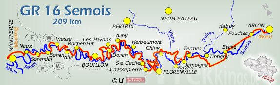
The route starts in Arlon (Belgium) and goes through Chiny - Florenville - Bouillon - Vresse-sur-Semois and Failloué to finish in Monthermé (France). The total distance is 209km with approximately 6000m of elevation.
http://www.trekkings.be/gr16.html
Maps: http://grsentiers.org/topo-guides/13-gr-16-sentier-de-la-semois.html
Dutch page: https://wandelen.groteroutepaden.be/nl/wandelroutes/waalse-gr-netwerk/gr-16-sentier-de-la-semois-2
French page: http://grsentiers.org/topo-guides/13-gr-16-sentier-de-la-semois.html
Main GR Page for Belgium:
https://www.groteroutepaden.be/ (Dutch)
http://grsentiers.org/ (French)