Location
Nevada,
US
Distance
8 mi
Vertical Gain
1,779 ft
Description
GPS Track
cat-in-the-hat103121-84817-am.gpx291.65 KB
Mescalito_ direct.gpx1.7 MB
FKTs
Male
| Jason Hardrath | 2h 25m 44s |
Male
| Stephen Lindsay | 1h 22m 40s | ||||
| Christopher C Gorney | 1h 34m 52s |


Comments
Travis,
Looks like they accidentally deleted my submitted route and kept yours.
here is my original submission
Submitted by Jason Hardrath… on Thu, 03/26/2020 - 08:52am
Location
Nevada, US
Description
Submitted by Jason Hardrath:
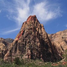
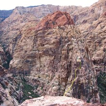
Mescalito is the pyramid-shaped formation splitting the Pine Creek Canyon within the Red Rock Canyon National Conservation Area (approximately 20 minutes driving time from downtown Las Vegas). From the approach trail, Mescalito looks like a miniature version of its near neighbor, Rainbow Mountain. Both share similarily colored characteristic rock bands - grayish lower portions and redish upper regions.
This FKT is for Pine Creek Canyon Trailhead->Mescalito Summit->PCC Trailhead, the route you choose up and down the Mescalito is up to you (feel free to include your Car-Summit time in your notes) there is an ammo box for a summit register at that top.
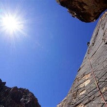
You can find various routes from 5.5 - 5.7 (or greater) on Mountain Project that will allow you to climb/scramble the rest of the way to the summit. Regardless this is an adventure climb full of hard scrambling no matter which way
You can also look through a class 3/4 descent (or maybe ascent too?) option on both Mountain Project and Summitpost.
Excited to see how ascent-descent routes get refined (new hybrids?) to optimize efficiency on both the Mescalito and the bushwhacky trails and washes below
https://www.summitpost.org/mescalito/151383
https://www.mountainproject.com/v/105732159
Hey Jason, sorry to not run this by you. Travis submitted the same route & I failed to recognize that we already had it. You did not provide a GPS track so it was easier to keep his route and switch your FKT over to that. Also, you had said "any route", but you did Cat-in-the-Hat, so it seemed appropriate to make a TH-TH FKT for ascending via that route. So, long way of saying the deletion was intentional to avoid redundancy and clarify the route.
No worries Peter! Appreciate the explanation!
I am really curious about this route. I see Travis is credited with submitting the route, although the description and current FKT are from Jason Hardrath? I am curious to know if Mescalito has to be climbed via Cat-n-the-Hat? I believe I can scramble the descent route up and down faster than the current time, but don't want to go for it if it wont count as an FKT. Can someone please clarify the current FKT and if its an open route to Mescalito or if it has to be climbed via CITH? Thank you!
It's not for me to decide, but I'd like to see it be TH-to-TH by any route, perhaps broken down by route if/when it sees enough attention. It's more interesting when people can choose whichever route plays to their strengths.
It was my original submission to leave it open to any route. Due to some errors my original submission was "unfindable" so Travis repeated this via the classic Cat in the Hat, submitting his route upon completion, but then finding my time was still faster.
It is now my opinion that two variations should exist for this route "Any Route" and (due to its ultra-classic status) "via Cat in the Hat"
I think this allows for optimal engagement with the most people. both for those willing to attack the most classic line and those who want the scramblers routes.
This is how the neighbor "Rainbow Mountain" has been handled. and I think it has been quite effective.