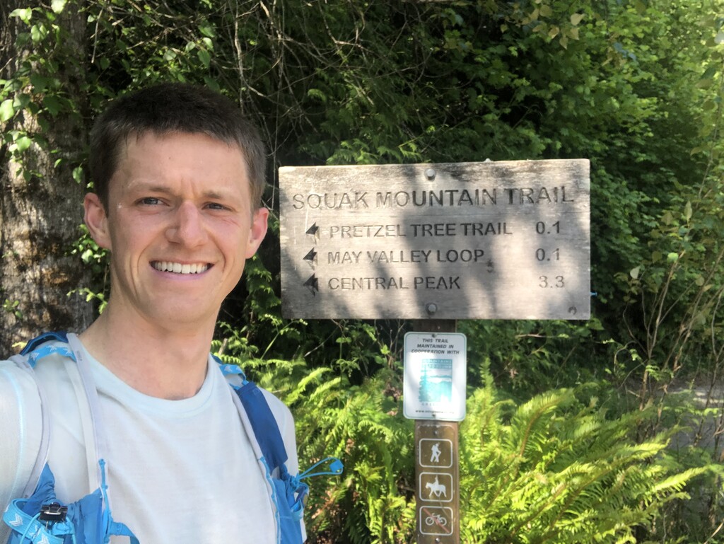
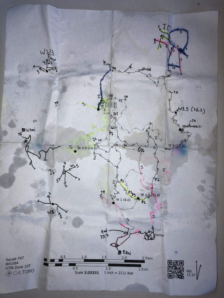
Route: I ran a different sequence of the trails than the one given in the description, with the effect of shaving off a good chunk of elevation and some distance. I hadn't run on Squak before I did some scouting starting ~1 month ago, so I leaned heavily on the Strava heat map and my scouting trips to build a picture of which trails were fast (and therefore good candidates for downhills or doubling up) and which were slow (best to only do once, going up). I picked start and finish points on the mountain, and I also used roads to link up some trailheads. The time I spent on roads is included in the total. These variations seem acceptable based on the description and FKT guidelines. I covered all the trails and roads that Ben and Kevin did. The description states the route is single track in Squak Mtn State Park, however it actually includes some gravel/dirt road and covers King County, City of Issaquah, and some private land (presumably with a public access easement). An expanded route might include the trail under the power lines below Mountainside Drive as well as more of the named-and-marked road-turned-singletrack near the Margaret Way TH. In the absence of another rigorous definition, "at least what Ben and Kevin covered" makes for a great route (thanks to them for putting it together!).
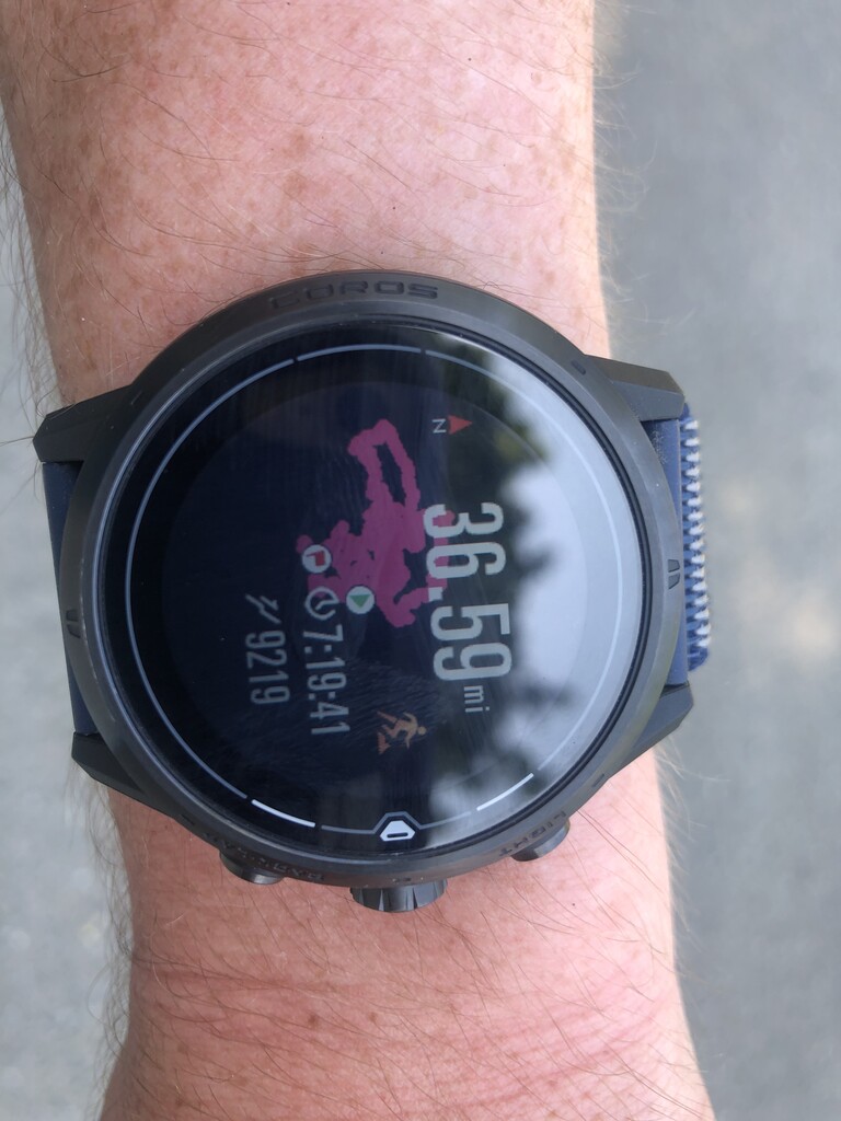
My run: I wasn't sure this would work in the spring, especially with the hot and sunny May we've had. The trails are getting brushy, and the streams are getting low. Nonetheless, I left the trailhead around 6 to get to the beginning of my route at the southeast summit, starting the clock at 6:55 am. I covered the south half of the mountain first (before those trails got sunny and hot), then headed to Margaret's Way (using SR900), then did the north half as the day warmed up (using Wildwood Dr), finishing with the central peak and a quick descent on the gravel road. I primarily used my watch for navigation (I didn't carry my phone), but as a backup I scratched some notes onto a poor-quality printout of the route; I somehow didn't make any big mistakes, only losing a minute or two figuring out which way to go. Looks like I missed 50' of trail in the Equestrian loop (the map is missing the trail segment), but I added 100' on the Maple trail off of Margaret's way TH, so please accept my apology! I ran unsupported and alone, carrying snacks and a filter bottle to drink from streams. It was 75 F with a dew point approaching 60 F when I finished, so hydration was the biggest challenge; I cramped a bit heading up Margaret's Way before I could rehydrate sufficiently, then things felt fine the rest of the run. I filtered a dozen times and drank ~5 L of water. I carried a soft flask with super-strength Tailwind to keep the salt and glucose flowing. The stats ended up being 36.6 miles with 9220' gain and 10270' loss.
Water Conditions: I had used my scouting trips to rate each stream for filterability and was surprised to find about a dozen good options on the mountain, even into May. The water was noticeably lower today than my last scouting trip 6 days ago. There's a USGS stream gauge downstream of the north side of the mountain called "Issaquah Creek Near Mouth" which measured 40 ft^3/s today; it was 60 ft^3/s only 6 days ago, and it's still dropping fast. You might have trouble getting enough water when it drops below 20 (it's far from a direct relationship, be warned). I only lost a minute or two today messing about trying to find water deep enough to scoop, but I wouldn't have wanted to wait much later.
Trail Conditions: The brush mostly consists of soft stuff (if you count trailing blackberry and salmonberry (?) as soft) which isn't quite at an annoying density yet, although there's quite a concentration of stinging nettle along the outer Equestrian Loop east of May Valley. I managed to avoid the nettle today, but it took some dancing. Ideally, I would have done this about a month earlier when there's better stream flow and less brush. The trails are well-drained, so mud wouldn't be too much of a concern. There's been some recent trail work (only a few blowdowns remaining) as a consolation for my poor timing.
See my planned route with water filtering spots and a bunch of other research notes (mostly about water) here: https://caltopo.com/m/E17UF