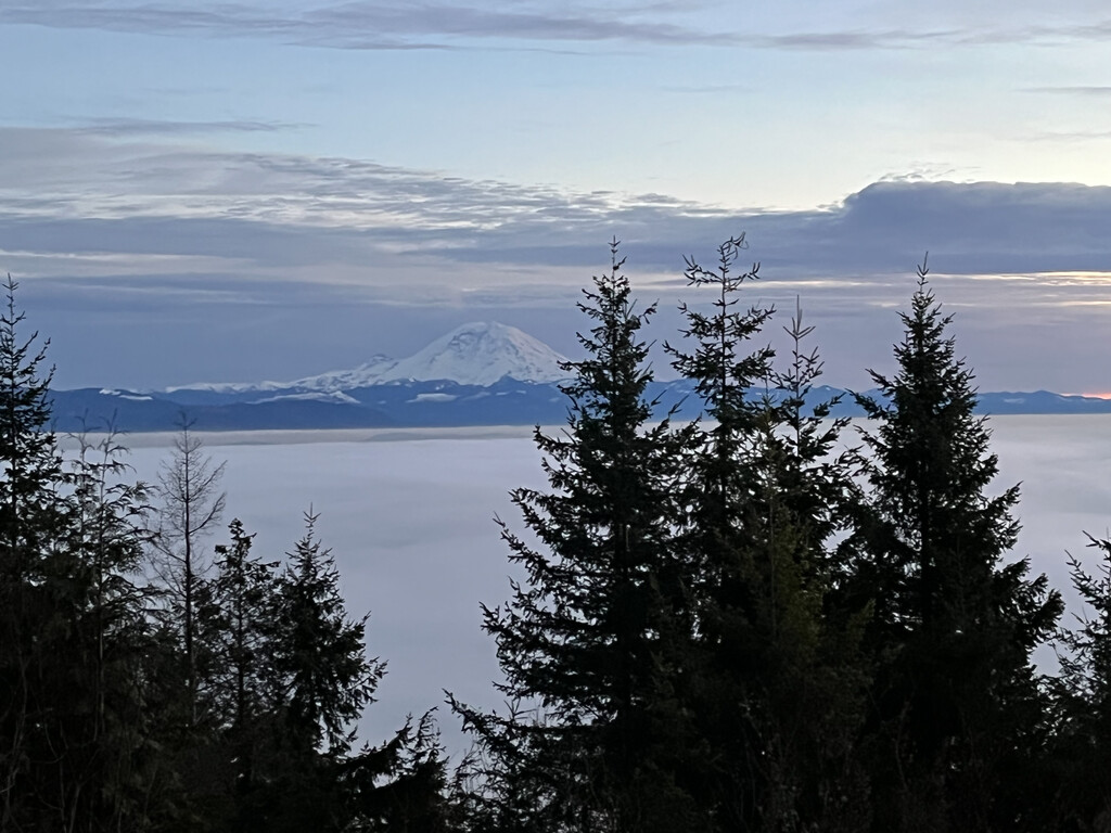
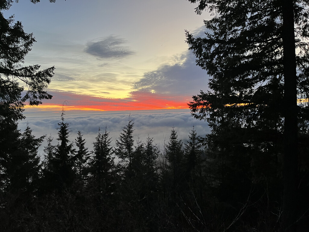
All of Squak is the shortest route that covers all of the publicly accessible single track trails in Squak Mountain State Park in Issaquah Washington. It is a mountainous 66km route, with 3895+ meters of elevation gain and loss, with multiple sustained climbs and descents. Enjoy literally all that Squak Mountain State Park has to offer with beautiful views of Mount Rainier and the Olympics (at Debbie’s views), as well as Tiger mountain (from the E Ridge Trail) to lush and solemn forests, to tranquil open areas (viewpoint on Margaret’s way), as well as amazing and well maintained trails and bridges across the entire mountain.
A suggested route is described below, broken up into five big climbs/descents. Should another runner choose a different route to cover all the trails at Squak faster, they can run that alternate route instead, but they must still cover all the trails.
Part I
This version of the route starts at the trailhead on Sunrise Pl. First you ascend Squak mountain access trail then take a left on Sycamore access trail, and do an out and back to the road. Continue up the E ridge and take a left to do an out and back to Southeast Squak peak. Continue on the E ridge trail until the intersection with Phil’s creek trail. Take a left on Phil’s creek trail and head down and take a right on the Equestrian loop. Continue on the Equestrian loop for 1.2 miles then take two immediate rights, and then a short steep descent, pass an intersection, then turn around at the next intersection, and take a right at the intersection you just passed. Run 0.2 miles until a three way intersection, and take the trail going north until you reach a right turn (may have to do a little extra ~100 m to the left to intersect where you were before). Go right and then return to the intersection above the bridge on the equestrian loop. Continue across the bridge on the Equestrian loop trail, and cross Squak Mtn Road, then stay left on May Valley Loop to the May Valley trailhead. Run the Pretzel tree loop.
Part II
Run up the Squak Mtn Road then take a right on Phil’s connector. Stay left on Phil’s connector at the intersection with the Equestrian loop and at the intersection with Phil’s Creek trail. Take a right on Squak mountain Road and continue to the summit of Central Squak Peak. Start descending C1- Central Peak Trail then take an immediate left (<100 m). Take a right on the Bullitt Fireplace Trail, then a left on C1- Central Peak trail until it intersects Bullit Fireplace Trail. Turnaround go 0.2 miles, then take a left. At intersection with E side trail take a right, then an immediate left and do an out and back on the Huckleberry trail. Take a right on the East side trail, then go straight when it turns into the Bullitt Fireplace trail. Descend to Mountainside Drive trailhead.
Part III
After touching the trailhead take an immediate right on an unnamed trail and do an out and back to a powerline cut below. There are also two short out and backs off this trail, but don’t cross over onto private property. Continue back up Bullitt Fireplace Trail, then take a right on the Coal Mine Trail, and then a right on the W Access Trail. Descend to SR900, then turnaround, and ascend the W Access Trail until the intersection with the Bullitt Fireplace Trail, take a left to hit the intersection with E side trail, then turnaround and continue ascending the Buillitt Fireplace trail. Take a right at the Chybinski Loop, then a left on Margaret’s Way. Descend 1.9 miles, then do a short out and back to the viewpoint. Continuing descending to the Margaret’s way trailhead.
Part IV
Turn around, and on the ascent stay straight on Juniper, turn left on Highland, then right on Madrona, with a little out and back on Maple (<200m), and continue on madrona until you reach an intersection. Turn around and return to Highland, and take a right on Juniper, and another right on Laurel to return to the Margaret’s way trail. Ascend Margaret’s way, take a right on the Chybinski Loop, than an immediate right on the W Peak Trail. Continue over West peak, then take a left on the Buillitt Gorge Trail, and an immediate left on the Buillitt Fireplace Trail. Continue down until you intersect with the Chybinski Loop, turn around, and ascend back up, then take a right on the Bullitt Gorge Trail. Descend on the Bullitt Gorge Trail until you intersect the Perimeter Loop Trail, then turn around ascend back upp the Bullitt Gorge Trail, then take a right at the Bullitt Fireplace Trail. Run past the Bullitt Fireplace, stay on the Bullitt Fireplace trail until you reach the intersection with the C1- Central Peak Trail. Take a Right on the C1- Central Peak Trail, run up ~ 0.25 miles until you reach the trail intersection past the metal gate near the top of Central Peak, turn around, then descend 100+ meters, then tak ea right on Old Griz Trail. Descend Old Griz trail, then take a left on Phil’s Creek Trail, and run until you intersect with the E Side Trail. Turn around, and continue on Phil’s Creek Trail until you reach the intersection with the E Ridge Trail. Turn around, go <100m then turn left on the Summit Trail until you reach Squak Mountain Road. Turn right on the road, and descend until you take a right to do an out and back on the Horse Connector. After returning to the road, continue descending about 0.6 miles, then take a right. Take a right on the May Valley Loop, cross a stream then stay straight and do an out and back to SE 122nd st. Return to Squak Mountain Rd. Descend until you take a right on the Equestrian Loop (half a mile), then an immediate right on May Valley Loop.
Part V
Ascend on May Valley loop until you reach the intersection with the Bullitt Gorge Trail, and take a right on the Bullitt Gorge Trail. Continue ascending then take a left on the Perimter Loop Trail. Ascend the Perimeter Loop Trail until you reach the turn for Debbie’s view. Do an out and back to Debbie’s view, then a left on the Perimeter Loop Trail. Take a left on the Chybinski loop, and an immediate right on the Chybinski Trail. Descend the Chybinski Trail until it reaches the Buillitt Fireplace trail, then take a left and an immediate right to do a short out an back to the Sierra Ct SW Access. Turn left on the Bullitt Fireplace Trail and ascend until it turns into the E Side Trail. Continue on the E side Trail until you intersect the E Ridge Trail, then descend to Sunrise Pl.