


Bartram Trail FKT Report (Female, supported):
Most parts of the Bartram trail are between 45 minutes and 2 hours from my home in Northeast Georgia. I became aware of this trail after moving here in 2021 and the idea of attempting an FKT has been slowly brewing ever since. I have enjoyed many hikes and runs on this trail over the last few years and was excited for the opportunity to take on the whole trail from end to end this spring.
After reading previous trip reports and scoping out the trail, I elected to camp at the top of Cheoah Bald the night before, rather than hike up the day of my attempt. I was very happy with my decision, even though it added some logistical complexity. For me, it was worth it to have a full night's rest after the long, steep climb (over 3300 feet of climbing in a little over 5 miles), enjoy a relaxed morning on the mountain, and start my FKT attempt on fresh legs.
Weather conditions were about as close to ideal as I could have hoped. I had been mentally preparing for a run in the heat, but the weekend ended up surprisingly cool for this time of year. The forecast showed possible rain for Saturday morning, but Cheoah Bald just had clouds and a light mist. During the day sections, it was generally partly cloudy to sunny and warm, but not overly hot with temperatures in the 60s to lower 70s. Saturday and Sunday nights were both clear with temperatures quickly dropping down into the 30s.
I woke up around 7, so I had a couple of hours to pack up my gear and enjoy an unhurried breakfast of oatmeal and coffee while soaking up the views. Watching the mountains fade in and out of view in the mist as I enjoyed my hot coffee was very peaceful and helped put me in a good headspace before my run. I don't often have the opportunity for such a relaxed start before races or big runs and I think this really contributed to good energy levels and a positive experience.
Part 1: Cheoah Bald to Nantahala Lake: Miles 0 to 23, May 2nd, 9:00am-4:15pm
I started my watch at 9am and set off down the mountain. CJ took pictures as I started and carried my camping gear down after I departed. I made good time running down from Cheoah Bald and was able to maintain a steady pace at an easy effort. I had my first support crew stop at Duke Energy (mile ~7.5) right around 11:00, where Hannah met me with snacks and Gatorade, plus sunscreen.
The following climb wasn't too steep and I was able to make very good time power hiking this section. The last few miles before Apple Tree Campground were one of the only sections I hadn't been able to preview in training, but fortunately the trail was well marked and not difficult to follow. Colleen and her family were camping at Appletree (mile ~18) and she met me at the gate around 2:28pm with more snacks, hydration, and sunscreen.
I had run the following section in training, but still ran into a few small navigation issues. This part included some unpaved roads and I did have to pull up my maps a few times to check my location or spot a turn. Fortunately, I didn’t lose more than a few minutes and was still making good progress. Before long, I met Colleen again at Lake’s End Cafe around 4:15pm (mile ~23). I reapplied sunscreen and stocked up on snacks and hydration for the long climb up Wayah Bald.
Nanthala Lake to Wallace Branch: Miles 20-41.5, May 2nd, 4:15pm-Midnight
The climb up Wayah Bald was a tough one. I had been very pleased to be averaging over 5k an hour up until this point, accumulating a small buffer above my goal pace, but that dissolved rapidly in the first mile or two of climbing. I had planned for a slower climb, but it was still a psychological challenge to watch my average pace drop so dramatically. Even so, it was a beautiful section and I had the memorable experience of seeing a black bear running through the trees in the distance. By the time I reached Sawmill Gap (~mile 27), the wind had picked up and temperatures were dropping. Even with the steep climb, I needed to get out a long-sleeved shirt to stay warm.
Shortly after the Bartram Trail joined the AT, I saw my pacer, CJ, who had run down to meet me. Seeing a friendly face had me feeling energized and I was able to power through the last mile to the top in good time. We met my dad at the top of Wayah Bald (mile ~31) at 7:33. By this time, it was really getting cold. I warmed up with a cup of hot coffee, changed into long pants, and put on a fleece, hat, and gloves. After grabbing food and water, CJ and I set off for the ~11 mile downhill to Franklin.
I remembered from training that this section was slower than expected. The hike down from Wayah Bald looks mostly downhill on paper, but actually includes substantial climbing along the way. Every time I thought the climbing must be finished, we would come across another steep uphill. I think we measured something like 2500 feet of climb on this “decent”. I think we spent almost as much time climbing as actually descending! It really wasn’t until the last two miles that it felt like we were losing elevation consistently. It was midnight by the time we arrived at Wallace Branch.
Part 2: Wallace Branch to Hickory Knoll: Miles 41-62, Sunday, May 3rd 12:00am – 4:44am
At the trailhead (mile ~41.5), Selena and a few others were there to meet us with hot coffee, cookies, and ramen. They had even made a sign to cheer me on! I think this was the first time someone has made a sign for me; I always felt like having signs from supporters was something that happened to other people. It made me feel very loved and supported to know they had made it for me.
CJ returned to his car with plans to get a few hours of rest before rejoining me on the trail at Hickory Knoll. I stopped briefly to put some Compeed on a hot spot that had formed on one of my feet, put on a high-vis vest, and then I was ready to get moving on the road section. I left my pack in the car, took my cup of ramen and set off at a power walk along the road.
Even while eating my noodles, I was able to keep moving between 5 and 6 kilometers an hour. They followed along in the car and I was able to pass my noodle cup and fork back once I was finished. I continued to power walk along for a while downing a cup of coffee. Once that was finished, I was able to actually run along the road. My legs were fortunately on board with running and I was able to make good time through the following section.
We met my father at Big Bear (mile ~45.5) around 1am and I quickly grabbed my pack again before starting off on the greenway section. I was moving well, but did have some difficulty navigating between the end of the greenway and Macon County Fairgrounds. I had practiced this section in training, but I’d only had the opportunity to do it once and it was more difficult in the dark with the fatigue of having run nearly 50 miles so far. I probably lost 10-15 minutes and tried my best to stay calm as I backtracked and searched for blazes to get back on route.
Once I reached the fairgrounds, I had another section of road running. I met my dad and stowed my pack in his car. This was the ~50 mile (~80k) mark and I chose this point to switch watches. My dad was able to charge the first watch in his car after I turned it off. He drove next to me with his headlights on and I felt strong and steady as I ran the road section. I was able to maintain a consistent pace of right around 15 minutes a mile (9 minutes per kilometer) for the next seven miles to Hickory Knoll.
Part 3: Hickory Knoll to Rabun Bald, Miles 57-82, Sunday, May 3rd 4:44am-3:20pm
We arrived at Hickory Knoll (mile ~57) around 4:30am. CJ was there to meet us and we took a few minutes to fuel up and gather our gear for the long climb up to Jones Gap. This took a little time and we departed at 4:44am. This was approximately the halfway point, distance-wise, and I was just under 20 hours. I knew a 40 hour finish wouldn’t be realistic at this point, but I was optimistic that I was still on pace to make it in under the previous record (44 hours, 36 minutes).
I picked up my hiking poles for this section, which turned out to be a good choice. The climb was long, but didn’t feel as steep or difficult as the previous climb up Wayah Bald. As we ascended towards Jones Gap, we also had a beautiful sunrise to enjoy. It was a relief to take my headtorch off and watch the glow on the horizon slowly brighten and fill the sky. I think the sun came up right around the time we reached the Bus (an old abandoned school bus on the mountain).
We didn’t have crew meeting us at Jones Gap (~mile 66), but we did finally have a break from the climbing. We had a brief wrong turn down a side path to an overlook, but we quickly recovered and found the correct trail. Trilliums were still in bloom on the ridge and walking through expansive fields of flowers in the early morning light was beautiful. There was still frost on the grass, so it must have been cold up there overnight.
The following stretch to Osage Overlook was beautiful, with some of my favorite views on the trail. However, I had made an error in my plans for pacing and meeting crew, so I had set my expectations for this section to be 2 to 3 miles shorter than it actually was. I was moving well, but falling behind my expected timings. Even though I felt energetic, I just couldn’t get my sleep-deprived brain to do the math to figure out what had gone wrong in my calculations. All I could do was keep moving forward at the best pace I could and hope it would be enough.
Elizabeth had been patiently waiting for us at Osage Overlook (~mile 73), where we arrived on the very late end of my expected timings. I was concerned about finishing under the record at this point, but convinced I was moving well. After a much needed breakfast sandwich, I took a few minutes to look at maps and my pacing chart. I figured out that the following section to Rabun Bald was a few miles shorter than I had written, but the math was still feeling pretty muddled in my brain. I knew Rabun Bald was just about 31 miles (50k) from the finish and that there were no major climbs after that point. We decided that the plan was to push forward to Rabun Bald and that I wasn’t allowed to attempt any more math until I arrived there. CJ returned to his car (which my father had left at Osage Overlook for him), so that he could rest before rejoining me for the final 18 miles at Warwoman Dell.
Once I settled on a plan, I had a burst of energy and charged off towards Rabun Bald, moving faster than I had in hours. I flew by Hale Ridge Road (~mile 77) and then continued on for Beegum Gap (mile ~81), where Elizabeth had planned to meet me again. I didn’t see anyone there at just before 2:30, so I made a quick evaluation of my supplies. I had enough snacks in my pack and I knew I could filter water, so I decided to continue on up to Rabun Bald.
I pulled out my phone to quickly text my crew so they wouldn’t worry and a quick glance at my messages showed that my InReach was no longer sending my location. It had run out of battery, so my crew hadn’t been able to track me. I lost some time texting on the way up, but was able to get a message out. I later found out that my father had tried to meet me at Hale Ridge Road when he realized the tracker wasn’t working, but I had blown through so quickly that I had missed him.
Part 4: Rabun Bald to Russell Bridge, Miles 82-112, May 3rd, 3:20pm-May 4th 4:44am
I made it up to Rabun Bald (~mile 82) and chose that time to switch watches. I started my watch at 3:20, which was 30 hours and 20 minutes from when I had started. I knew this meant I had well over 14 hours to run the final ~31 miles (~50k). At this point, I felt confident that as long as I could avoid any major disasters, I would be able to finish under the record.
The 12 miles down the Warwoman Dell took a little longer than I hoped, but I was still moving well, especially considering how far I had already come. I could feel several more blisters forming on my feet, but didn’t want to stop, so just tried to push through to my next crew stop. I made a brief stop to filter water at a creek and made it a few hundred feet down the hill before I realized I had left my poles on the ground. Fortunately, I didn’t have to backtrack for long, but I could tell my brain wasn’t firing on all cylinders anymore and simple tasks were taking longer than they should.
When I was about an hour away, I tried to send out a text with an update of my progress, but I was concerned that crew waiting for me at Warwoman Dell might not have signal. The last few miles from Becky Branch Falls seemed to stretch on forever as night slowly began to fall. These were very familiar trails to me, but after something like 90 miles and 35 hours on the trail, my perception of time and distance were feeling muddled.
I arrived at Warwoman Dell (mile 94) around 8:30, just as night was falling. My dad was waiting for me and I could tell he had been worried because he hadn’t been able to receive my messages. CJ was also ready to rejoin me on the trail for the final stretch. I took a few minutes to regroup and change into warmer clothes. I also need to take some time for foot care, cleaning out my socks and applying more compeed to my feet. I had several blisters, but I just got them covered up and tried not to think about them too much. With less than 20 miles to go, I felt confident that I could push through. At about 8:40, I was ready to depart.
The going was a little slower than I had hoped through the small hills out of Warwoman Dell, but I was able to keep up a reasonable power walk for the most part. We reached Pool Creek Road (mile ~99) right around 11:40pm. It took a minute for my father and I to find each other the dark, but we were able to make a quick stop for coffee and a few bites of instant noodles.
It was only 4 miles to the next stop at Sandy Ford (mile ~103) and we were very ready to push for the finish. The trail was smoother going and mostly downhill, so I was flying (at least by the standards of 100+ miles trail runs). We covered the distance in just over an hour, arriving at 12:50 for a very quick stop. At this point, we were down to single-digit miles remaining and I started to let myself feel excited. This was really happening!
The final crew stop was at Earl’s Ford (mile ~106). We made good time again and arrived just after 2:00am. We took a few minutes to make sure we had enough warm clothing and head torch battery life. We had 3 and a half hours to run the final 6 miles, which we knew would be plenty of time. Of course, I was still eager to finish as quickly as I could.
This section of the trail had a few more hills, so I wasn’t able to run as quickly as I would have liked, but I was still moving and it was clear that the record was within reach. I was able to enjoy the full moon reflected on the Chattooga River and the glow of Mountain Laurels in my head torch light.
I remembered making a mental note in training of crossing a bridge just before reaching the highway, telling myself that once I reached the bridge, it would be time for a celebratory sprint to the finish. What I had forgotten was just how many other bridges I crossed in the last few miles. I think there were at least 5 or 6. Every bridge I crossed, I kept wondering if it was the last one. I was sure there had been something distinctive about the final bridge, but I was too tired to remember what. Time was feeling distorted and this section measured a little longer than I was expecting. At long last, we crossed a much larger bridge that stretched all the way across the west fork of the Chattooga River and I knew I was just minutes from the finish.
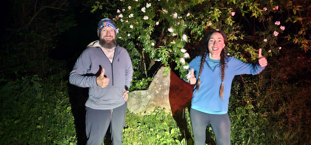
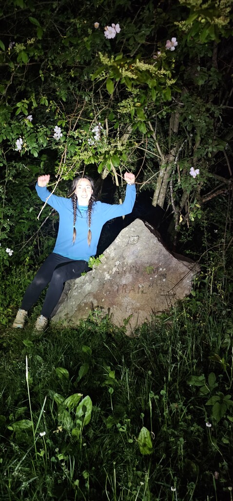
Once I reached Highway 28, I quickly checked for cars and sprinted across, stopping my watch when I touched the rock marking the southern terminus of the Bartram Trail. CJ excitedly announced that it was 4:44am and 44 seconds by his watch. This put our finish time at 43 hours and 44 minutes, or 52 minutes under the previous record. My father was there to meet us, and we took a few quick pictures.
For the first time in over 40 hours, I finally allowed myself to relax. The whole situation felt surreal and I could barely believe all that had really happened. It was just the three of us there in the dark, off the side of the highway, quietly celebrating an extraordinary moment.
Gear (run):
Ultimate Direction running vest Signature Series 6.0
Ultimate Direction soft flasks
Katadyn BeFree water filter
Altra Lone Peaks
Injinji Toesocks
Petzl Nao RL headtorch, with two additional spare battery packs
Garmin InReach Mini2 (As a note to future runners, battery life was not sufficient for 10-minute live tracking, at least with my specific device and conditions. Despite a mostly new device and starting at full charge, battery was only sufficient for ~24 hours of continuous tracking.)
Garmin Fenix 6
Garmin Forerunner 55
Lululemon shorts
Zenash Sports Bra
High-Vis Vest
Compeed
Gear (camping):
Gossamer Gear The 2 tent
Therm-a-rest NeoAir Xlite
Therm-a-rest camping and backpacking pillow
Mountain Warehouse Extreme Lightweight Down Sleeping Bag
Nutrition:
Gu gels
Gu stroopwaffles
Revvies energy strips
Beverages: Coffee, Gatorade, and water
Packaged snacks: oatmeal cream pies, fruit snacks, peanut butter cups, potato chips
Other food: Cup noodles, turkey and cheese sandwich, egg and bacon biscuit, cookies
Other notes:
Distances are approximate, which is to be expected, especially for a trail of this length. Different sources list slightly different distances for the full trail, between 111 and 115 miles. The route has had some changes since the previous female FKT, but to the best of my knowledge, the overall length is similar. I attempted (to the best of my ability) to follow the most current version of the route, following yellow blazes and official paper maps purchased in 2026. My personal experience, based off of watch measurements, is that the trail measures on the long side of these estimates I would recommend assuming closer to 115 miles for pacing and planning purposes.
As a note, the time I entered is the sum of elapsed time of my three recorded activities from my watches. This is very slightly different than times based off what I calculated from time of day, since my stop/start times may not be 100% precise.
The starting point at Cheoah Bald is not located at, or even very near, a road crossing. I chose to camp at Cheoah Bald the night before in order to avoid a long hike in on the day of my FKT attempt. I was very happy with this option and would recommend it to future runners.
Thank you:
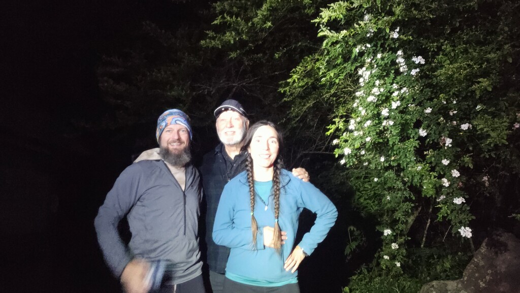
This run would not have been possible without all the family and friends who supported me, both during training, and during the run itself. Thank you to my mother and husband for holding down the fort at home and taking care of our two-year old son while I was running. Another thank you to Hannah, Colleen, Selena and co., Elizabeth for taking the time out of their weekend to crew. Special shout out to my dad (crew chief) and CJ who carried my camping gear down from Cheoah Bald and paced me for close to 50 miles.