Foster's Report:
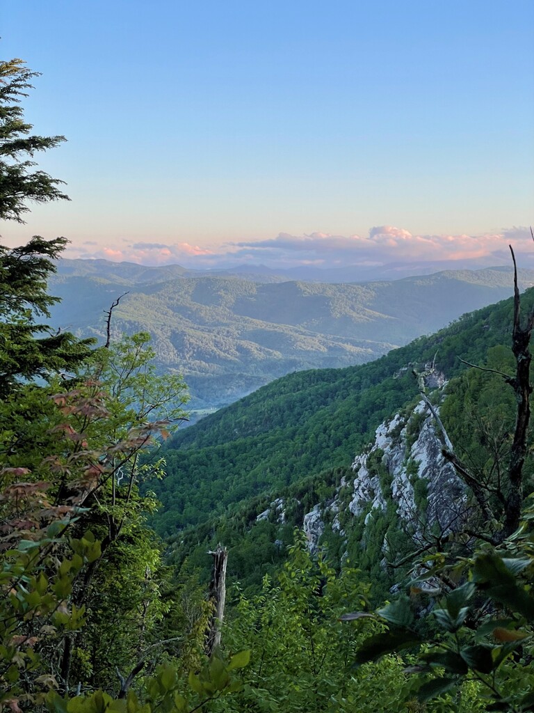
We would confidently put this route up there as one of the most scenic and rugged 99-milers you could put together in the southeast. Starting first with 7 miles up and over Grandfather, the route follows sections 5, 4, and 3 of the Mountains-to-Sea Trail (MST) for the remaining, ending at the highest point on the east coast, Mt. Mitchell. We had previously trained for this route in 2023, but got sidelined with injuries, and so a Spring 2024 start was booked. We decided on an “Unsupported” attempt for a variety of reasons: plenty of water access, not having to retrieve our cache drops at the end, reducing the burden on family and friends helping to crew, and the logistical challenge of being reliant on just yourself (and the other person feral enough to do it with you). Really, how hard could it be? Just a long day(s) in the woods.
Training: This started for me right after the holidays. Always a convenient time for me to add discipline in my life. Unlike previous training plans where I would put some time into speed, I pretty much solely focused on increasing time-on-feet and elevation gain. Lots of Z1 and Z2 activities. Workouts were substituted for specificity training. Hiking became a daily activity and gear strategies were being constantly vetted. My biggest weeks were less than 60 miles volume, +/- 12 hours’ time-on-feet, and over 10,000 ft of vertical gain. That said, I felt good for the start. Not burnt out mentally, nor beat up physically.
Weather: With an abrupt taper, we started a week earlier than planned to take advantage of cooler weather and less rain. This was critical in reducing our gear weight, keeping our feet and bodies intact (as best as you can), and maintaining a positive morale. Temperatures ranged between mid-40’s at night and mid-70’s during the day, with intermittent cloud cover and a slight breeze. For the exception of the heat from a few exposed sections after Woods Mountain, the weather was a dream. Coincidentally, it did feel like a dream on the climb up to Table Rock as we witnessed a red aurora in the sky that had us questioning how we were hallucinating only 12 hours in. Per usual, we finished in the mist and gusty winds that always seem to accompany Mt. Mitchell.
Nutrition/Water: This is what made up the bulk of our pack weight. We each carried over 12,000 calories split into six 6-hour bags. Each bag was somewhat catered to what we thought we might need during certain times of day or after so many miles, each with a balanced combination of carbs, fats, protein and sodium. I thought this strategy worked well in breaking down the enormity of the run on the nutritional level. It also helped in keeping loose track of whether you were over or under on caloric intake. What I didn’t get right was some of my food choices and the way I consumed. Hindsight, I should have drunk more calories during the day and saved more solids for the slower evening miles. When I started, I was set on eating 90 carbs an hour and did so for the first 12 hours, but my body couldn’t digest it fast enough and slowly started to get nauseous and disengaged with food. This made for a tough next 12 hours until I balanced back out and could eat normally again. Best food choices were gummy bears, granola, Biscoff cookies, and Ramen. Skratch hydration and recovery saved my life. I will never try another backpacking meal no matter how enticing it sounds. I used the Salomon XA filter for all my water. Water was well supplied along the route with only a few questionable sources around Dobson Knob and Mt Mitchell that we pulled from (still no signs of the poopies). However, we did have a roughly 12-mile section starting near Woodlawn that we had to mule up for.
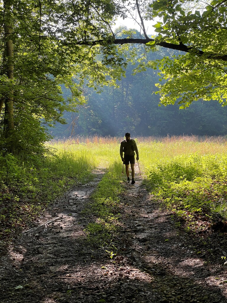
Trail Conditions: The trail less traveled. The MST is quite a contrast to the AT. Feels like the difference between skiing backcountry vs resort groomers. Harpers Creek (over a dozen creek crossings), Table Rock to Shortoff (severely overgrown), Dobson Knob to Catawba River (primitive), Toms Creek to Woods Mountain (thigh high poison ivy), and Neals Creek Road to South Toe Campground (very few trail markers) were the crux sections.
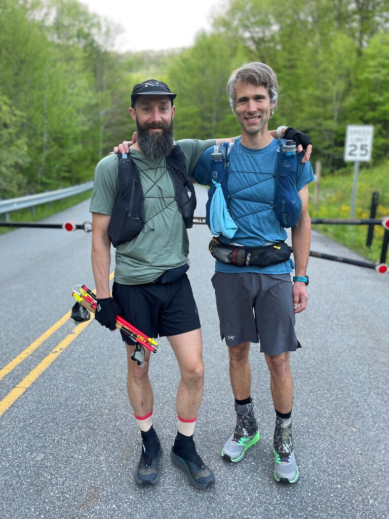
Gear: I used the Salomon Advanced Skin 12 and a Naked Belt for all my supplies. With probably around 12lbs of gear, the pack did incredible holding everything and not chaffing or bouncing while moving. Outside of food, I carried an extra pair of insoles, three pairs of socks, small tubes of Gold Bond foot powder and Squirrel Nut butter, a poop kit, emergency kit, Salomon rain gloves and trash bag, extra Salomon shirt and shorts, Patagonia Airshed Pro, Kogalla light with two batteries, Toaks pot, IPhone, wired headphones, Black Diamond trail gloves and Leki Ultratrail poles. Shoe choice was the Salomon Genesis with Altra Gaiters over Injinji socks. Nnormal hat and Coros Apex Pro round out the kit.
High Points: Ha! Too few to recall really. The one obvious one was getting to the South Toe campground and knowing how close the finish was, especially with how demoralizing the last section had been. The red aurora sky was really cool on Friday night. Never seen anything like that. Kind of thought Drew and I had already died, and our purgatory was to climb Table Rock under a blood red sky for eternity. Ramen was always a high point as was coffee with Skratch Horchata Recovery. The sunrise on Saturday was special too as we descended down from Bald Knob looking out at Woods Mountain and Mt. Mitchell and my stomach was finally coming around. Lastly, not sure if this was a high point but it was comical. There had been a lot of talk about creek crossing strategy to manage potential foot issues. Drew’s plan was to take socks and shoes off at every water crossing (miles 20 – 40) while I would take a more game time decision approach. On the first creek crossing, I confidently rock hopped most of the way using my poles to balance. My last jump though ended in disaster as I fell face first into the creek having slipped on the takeoff. Made worse by the audience that was crossing at the same time. My decision had been made for the rest of the “Waterworld” section.
Low Points: Ha! Too many to recall. At the 12-hour mark we hit Steels Creek. It was starting to get dark; we wanted something warm, and our feet needed some maintenance. After crossing a wide feeder stream, we made Ramen, filtered water, dried out our feet and changed socks thinking we wouldn’t see another large stream crossing until the Linville River. Not even 50 yards from our stop we were forced to cross over Steels Creek again, and then again, and again, and again, and probably again. This was a huge chunk of time lost and left us feeling foolish as we approached the huge climb up to Table Rock. My other low point was just after we crossed the Linville River and stopped along the bank to make our backpackers meal. The “crown jewel” of our nutritional supply. The thing that would bounce us back into the energetic optimists we started out as. What we got instead were flavorless bags of soup I can only describe as a type of animal feed. Mine didn’t quite reconstitute forcing me to chew, swallow what I could, and spit the rest out towards the side of the trail the way a small child might spit out sunflower seeds. To top it off I also found out I was missing one of my backup socks. How do you lose just one sock?!? The type of item worth its weight in gold on this type of adventure. This forced me to finish the run in a pair of ankle socks I had only run in once before (you can guess how that turned out). As I sat on the bank of the river putting my dirty pair of socks back on, a water snake came within a few feet of me moving toward the light of my waist light. I’m pretty sure it took pity on me and let me go unscathed, knowing that I still had the Pinnacle climb to further break the spirit.
Final Thoughts: Wow! That was hard. I like hard but dang that was hard. Cut and dry, this was the most challenging thing I’ve ever done, and I’m glad I got to suffer in it with a good friend. I’m beyond grateful to have the health to do this, the family to support me in it, and the friends to help me train for it. On the final climb, I remember thinking “this wasn’t fun”. On the drive home, I thought “that was crazy”. The next day I was trying to figure out ways to shave off time for the next attempt.
****
Drew's Report
Our original plan was to attempt Gritchell in May of 2023 in a self-supported style, stashing all sorts of gear and food along the route that we could access ourselves, just without the help of any crew. During my last high mileage training week in 2023 I rolled my ankle several times on a morning run then decided to make the day a double with some hill repeats. Turns out that was too much and even with poles in hand my left ankle rolled, popped and I immediately recognized the pain as an avulsion fracture. Bummer. Gritchell was obviously out for me for a while, and I spent the Spring healing, and the Summer & Fall regaining strength in the ankle. Many sunrise missions up to Grandfather. Ankle took quite a while to heal “completely”. Now I run 100% of the time with ankle braces on both feet.
Foster and I caught up in the Fall of 2023 and agreed to put this objective back on the calendar for Spring 2024. Two families, different jobs, kids, etc… made our attempt windows pretty small, we agreed on a target date of Mid-May with a 4-5 day weather window to take advantage of conditions as much as possible. During the initial planning phase, Foster casually mentioned that he thought we should attempt the route unsupported. I listened to him throw the idea out and might not have vocalized it but was thinking that unsupported would be just about impossible to accomplish. How can you carry 100 miles of calories in your pack and run at all? How do you know what food you aren’t going to reject at mile 86? What if I want to change shoes since the first pair got wet at mile 20?
Somewhere in the following weeks, my thoughts of dismissing the unsupported concept as impossible turned into curiosity – “Well, what if I can carry enough food to continue through the night and next day?” “What if I just stop being picky with food and eat whatever I have and don’t complain about it?”, “I can’t switch shoes, but maybe I can pack a fresh pair of insoles to change out?”, “We can’t have hot burgers with us, but what if I bring an ultralight stove setup to cook Ramen and Backpackers meals?” Not having to drive the route to stash gear was appealing, and the unsupported style is so pure I began to put some of the larger pieces together (in my mind anyway) to make this seem like an achievable goal.
Wintertime brought short days and long work hours for me, but I was committed to keeping run mileage as high as I could during this time. Lots of night running practice, and long runs followed by a full workday seemed like good experiences for a big effort like Gritchell.
We would catch up on the phone or text semi-weekly, sharing an idea here or there, discussing potential strategies, gear and food… One of the main issues I was trying to solve was how to best carry all the gear we needed. Could we quickly filter water for electrolyte mixes? I considered using some iodine or other purification tabs as an alternative to filtering.
Spring arrived early to the High Country, and we both started a focused training block consisting of decent running mileage with emphasis on time & vert, and also incorporated a good amount of hiking. I think the hiking was good on so many levels, gaining strength and stamina while also recovering from running efforts. There are usually a myriad of school-borne illnesses rampaging through our house during this time, but fortunately this year the viral load remained low and I was able to stay healthy a majority of the time.
As the weeks flew by and the goal date kept creeping up, I think both Foster and I started to get more nervous and intimidated by the objective. For me, continuing to work on planning and logistics helped with this, documenting potential foods and their nutritional info, looking at the full gear list and what different items weigh, compiling a lightweight but comprehensive first aid/blister kit, experimenting with filtration devices, etc…
The final week before we set off came so fast. Partly because we moved the date up one weekend to take advantage of a small cool front ushering fresh air into NW NC. This was so crucial, even though the route hits two of the tallest peaks in NC (Grandfather’s Calloway Peak sits at 5946’, and Mitchell’s Summit is 6684’) a lot of the trail in between ranges from 1000’-2500’, which is an entirely different climate with much milder temperatures.
The week of, we met a couple times at Foster’s office to lay out our different gear selections and nutrition and discuss our individual strategies for both. We knew we had to figure out how to deal with all the river crossings, a variety of temperature swings, and after studying the topo – there were a few sections that we would travel a prolonged period with no access to water, most notably miles 75-90 of the route up and over Woods Mountain to the Blue Ridge Parkway. All solvable problems with proper planning.
It was a difficult exercise to select only what I felt I needed gear-wise but the limited pack space and small weight allowance forced me to whittle down what I carried. One of the items I stressed was long pants. I thought moving slow during a cool night would call for them, but ultimately decided not to bring. Ended up working out great.
Foster had an excellent idea of breaking up our nutrition into 6-hour bags so we weren’t overwhelmed with choices and could keep track of intake better when divided up. I knew that personally during most of my longer efforts, sweet food did not work for the later stages. I craved salty, real foods. For a 6-hr bag, I aimed for 250-400 calories/hr, splitting even choices between sweet or salty. Any additional calories & especially sodium would be supplemented with Skratch. We tried to include a good variety across all the bags, which during the run worked well.
We both ultimately decided to use our Salomon Adv Skin 12 packs, along with a Naked belt to carry our gear. I tried on some larger capacity packs, but felt like the Salomon fit best, bounced less, and carried more load up front - spreading weight better and allowing easy access to gear and food we would need at that time.
I took the morning of May 9 to pack all gear and food early so it would be ready the day of with no stress. This took forever. With all the items splayed out on the floor beside the Adv Skin, it looked impossible to cram into that 12L pack. I started packing a few things here, a few things in another pocket, Skratch in the naked belt, and so on. I ultimately was able to just barely fit everything with a little custom shock cord external carry system on the back of the Salomon pack. I weighed myself with and without the pack on my home scale and estimated the pack and belt together weighed about 12-14 lbs. Gulp. This seemed massive for running. I had trained with the pack and a 2L bladder of water, but that was less than half this weight! I debated taking out a few calories, but to drop any sort of appreciable weight would take lots of food. I wasn’t comfortable with narrowing my safety margin of calories to that extent. Same goes with the gear I selected.
Not sure about Foster, but my sleep the night before was essentially non-existent, full of anxiety, listening to the wind whip around our bedroom window just knowing I would be out in it all day & night with 12 lbs on my back.
We decided to set off from the Profile Trailhead at 7am on Friday, May 10. Both our Wives and families drove us to the gate in the morning. With nervous smiles we hugged our families, and they wished us well as we walked towards the trailhead and lost sight of the vehicles. I couldn’t stop wondering while crossing the Entrance Road gate and walking up the road: “What the heck is in store for us?” It’s a good feeling to get started though, as you can stop all the worrying about doing something and transition into actually doing the thing.
First mile was easy breezy, a cool wind rushing through the new neon green leaves on the Profile Trail. Almost enough to drown out the 105 traffic noise. Hopes were high and we both agreed that the stuffed packs carried the weight very well and weren’t a crazy burden, at least yet. Whew. Once Profile leaves the Watauga River and begins the ascent, Foster led and established a steady and reserved pace that allowed us to keep effort very chill. We soaked up the fresh air and greenery and ended up on Calloway Peak just shy of 1.5 hr in. We picked up the Daniel Boone Scout trail here and descended with the same reserved pace, trying to keep impact at a minimum. Roughly halfway down DBS trail meets up with Cragway which offers exceptional views, especially back up towards Calloway Peak. Cragway dead ends into the Nuwati trail, which has a small wooden trough that a feeder stream flows through, and we both stopped to filter our first water of the trip. I kept one flask with straight water and Hydrapak filter, and one flask I would filter water into with added Skratch. A few tenths of a mile after the trough, we met up with the Tanawha trail and headed south towards Linn Cove & Beacon Heights. This trail is like home to me, as our house sits adjacent to the Tanawha just 4 miles north of this intersection. No pronounced climbs on the Tanawha does not mean this is an easy trail. Some of the more technical and rocky trail on the entire route. Foster and I were feeling fine and taking our time, enjoying some good conversation and making sure we were keeping up on eating and drinking, even though neither of us felt hungry or thirsty. We passed a few people on the popular trail up to Rough Ridge overlook, then a few hikers around the Linn Cove Viaduct. We joked about whether or not using a public restroom if the Visitor Center was open would count as “support” or not lol. We also focused on gratitude, enjoying and appreciating the fact that we are able to move across these beautiful trails. The rocks became larger and rockier, we passed creek bed after creek bed, over the Stack Rock Creek boardwalk, crossed 221, and were at Beacon Heights soon enough. From here, we knew the long descent to Gragg Prong was next, so we made a conscious decision to be patient and not let gravity pull us into an unnecessarily fast pace. The feeder creeks on this section were flowing with all the rainfall over the past week so we filled water some here. Technical trail led into a more buffed out bike trail, which eventually spit us out onto Old House Gap Road. Large large gravel chunks made for careful foot placement for a mile or so before transitioning into smoother dirt roadbed surface. Gragg Prong was babbling off to our right side and looked beautiful in the morning light. Bright white mountain laurel blooms contrasted with the dark green rhodo jungles by the creek.
It just happened that we reached the Gragg Prong parking area/Trailhead right at the 6-hour mark. Time to get our next 6-hour bag of food out and ready, as well as prepare for what Foster deemed the “Waterworld” section – for the next several hours we would be river hopping constantly. My plan for this section was to remove both my ankle braces, put on some very thin ankle socks, and lace my shoes loose enough to slip on and off quickly. I was going to take off shoes and socks at every crossing, dry off feet as best I could on the other side then quickly slip socks & shoes back on. I practiced this at home a few times beforehand; found it was only a roughly 30 second process - insignificant timewise, but crucial for me since we had no way to change shoes over the course of 100 miles. This Gragg Prong / Lost Cove area was one of the highlights for me; trails that were familiar, feeling good at the time, temperature was just right, filtered sun through a dense canopy above. We made relatively good time here and my shoe strategy was working out! We noticed several downed trees on this section, which would be the normal situation for just about the rest of the trip. We arrived at Hunt Fish Falls in what felt like no time at all. No swimmers today. The small climb from Hunt Fish to Pineola Rd. was one of the only sections of the day that felt shorter than we remembered! I had signal up at Pineola Rd., so I turned on the cell and texted my wife Lauren to give her an update on progress. Short plod down Pineola until it linked up with the North Harper Creek shortcut. Always love the scenery on this section – gently traversing down the side of steep gullies covered in ferns and mayapples. Kept taking the shoes off and on, off and on during the numerous crossings. The creeks got larger, swifter and deeper. Just beautiful. Although my strategy was keeping the shoes mostly dry, wetness was definitely present and creeping in as I couldn’t dry off the feet completely every time. Still much better than fully submerging. We both felt pretty great on this section, and were gawking at all the scenery, different waterfalls, cool campsites, huge trees, sandy beaches by swimming holes. We both agreed we should come back to the area at a more leisurely time when we could enjoy it more. Fortunately, the yellow jackets and hornets usually present on this section had not been around long enough in the season to amass angry armies. No stings. We eventually came to Harper Creek Falls and knew we were relatively close to the intersection with Raider Camp Creek. We sought out the freshest water sources and dialed in the process of filtering water on-the-go to mix with Skratch. Became like second nature. Harper Creek intersects with Raider Camp Creek at a hard turn in a flat campsite area. Shortly after this was the last water source for several miles, so we drank up and filled flasks before starting the climb.
The Raider Camp Climb was one of the more frustrating sections of trail, not because it was particularly steep or difficult, but it was just steep enough that we couldn’t get into any sort of running rhythm and was long. We started feeling a bit worn down here, probably calorie related. Forced foods down on schedule and carried on. The trail eventually flattened out where we could run again, and at one point opened up to provide a view of Grandfather Mountain. Although we had been moving for quite a while at this point, Grandpa still looked relatively close to us! Singletrack linked up with old roadbed and gently meandered around different mountainsides. Finally crossed a spring and filled up again on water. Upper Creek was the last large water crossing of the “Waterworld” section; we could smell a great campfire someone had going nearby. Short but steep climb from Upper Creek to 181, mostly buffed dirt with some large mounds along the way; nothing to do but relax and take our time.
It is always odd to be deep in a forest environment then suddenly pop out on a busy road. HWY 181 was typical, we crossed but had to cut fast to avoid all the traffic coming from both directions. We reminisced about our last time on this section; we ran from my house to Table Rock on the same day that the Table Rock Ultra Races were being held in 2021, and a kind Aid Station volunteer gave Foster a Ginger Ale to help settle things down. Sure would’ve been nice to have a cold ginger ale now!
The gravel road from 181 to Steeles Creek Trail was longer than we both remembered, but slightly downhill and easily runnable. One of the few “easier” miles on the entire route. Foster had the route downloaded to his watch for navigation, otherwise we would’ve both figured we missed our turn; it felt longer than we both remembered. We did not miss, eventually found the gate denoting the start of the trail and began descending to Steeles Creek. Made a conscious effort to keep the pace in check and keep impact at a minimum. The day was getting on, shade was creeping in and we were hungry for a hot dinner! We crossed a tributary to Steeles Creek and decided to break out our mobile aid station here, address our feet and cook some Ramen. I got the stove setup and water heated relatively fast for 2 packs of Ramen. While it was cooking, I checked up on my feet - they weren’t completely dry but looked very good all things considered. I decided to swap insoles and socks anyway to be safe and let the damp ones dry for a while. We packed up our gear, felt warm and cozy in our fresh dry footwear, enjoyed the first delicious bites of Rocket Fuel… er Ramen, and started down the trail feeling aweso….. aaaaaaand there was immediately another mandatory feet wet creek crossing. F#$%!!! This was quite an unfortunate setback in our minds as we were so diligent and spent a good amount of time to get our feet and setup just right. We searched for an upstream or downstream rock hopping option to cross but there were none. Had to go ahead and take all that nice new warm dry footwear off and get the feet wet again. We then decided to wait until the actual climb began in earnest before getting our feet dry and dialed again. Wandered through and around Steeles Creek with the sky turning dusky and darker as night kept creeping in. It was somewhere in this section, around mile 40 that I noticed some irritation in my front tendon that is responsible for flexing my foot (I later id’ed as the Anterior Tibialis). I’ve had this flare up once or twice in the past, usually on a long run with more pavement than I care for. This time I attributed it to all the descending and reserved pace causing me to possibly heel strike more than I usually would and overuse that tendon. I was more than a little concerned what 60 more miles would do to the irritation, but concluded it wasn’t broken, would probably heal, and right now it would either get better, stay the same or get worse, and I would decide what to do when and if it did get worse. In the meantime, I made a mental effort to not heel strike and land flat footed as much as was reasonable. Still, I felt the landing on that foot every. single. time. For the rest of the route.
This section was frustratingly slow for us with all the water crossings, techy and wet terrain and fading light. We both wanted to be farther along at this point, but this was where we were. I think I got in a hurry and started running slightly faster, eventually stopping when I heard Foster shouting, wondering if we were beginning the climb and needed to backtrack slightly to the last spring crossing to filter water. Probably a smart idea, as the Table Rock climb was void of water for what could be an extended period of time. Turns out it wasn’t quite the last access to water, but better safe than not.
The climb finally came right as the sun set, and we settled into a nice easy pace. On and on. And on. Twilight faded and we delayed getting our lights out to both conserve battery life and to have something to look forward to when we turned the illumination on. Good plan, except at one point we crossed a small spring/drainage area covered in moss that looked easy to step on and cross, but I quickly sank through and into wetness with my left shoe. Choice expletives ensued. That’s when I busted out the headlamp, but at a low setting. Even the low setting looked amazing compared to shadow squinting. Nothing I could do about the wet shoe now, just continue.
This was absolutely one of the hardest climbs for us. We persevered, almost got lost when we missed a turn before one of the gravel road intersections, heard some campfire laughter and smelled that enticing smoky campsite smell, and eventually found ourselves on the last section of trail up to the Table Rock Parking Area. Slow slow slow and steady, this combination of technical and steep was working on us for sure. About halfway up this climb, I look North towards Hawksbill and cannot believe what I am seeing – this eerie red glow/smoke on the horizon! This, coupled with a sliver of moon was just beautiful – but what was it? I asked Foster if he saw the red light also, as I figured it was much too soon to be hallucinating! He did, and neither of us knew what the heck was going on. I thought maybe it could be the lights from a distant city but that wasn’t quite right as they wouldn’t be that bright, or in that location. I joked that maybe it was the Apocalypse. Would be wild for us to be in the woods eating snacks as the world was ending. Ok then - red space lights noted, carry on.
We finally made it to the Table Rock Parking Area, and even though it was now 10:30pm or so, campers were still milling around getting gear prepped to setup camp! Another surreal situation after all the solitary dark woods. Is using a public waste receptacle to get rid of all your plastic wrappers considered support? Maybe. We didn’t use them. Took a few minutes to get some colder weather gear on, consolidate trash, and re-up on another 6-hour pack of nutrition. Please have some good sweet snacks in there…
Table Rock Parking through The Chimneys was slow as expected, technical rocky trail, no prolonged climb or descent, but plenty of short punchy sections of both. After The Chimneys the trail became very narrow and looked to have about 3 years’ worth of unrestricted vegetation encroaching on the path. It wasn’t great to pass through, I’m just wondering how many ticks were getting free rides as I plow through all these plants. Some variety of pine tree had stiff needles that almost hurt as you brushed against and through them. Thorns also of course. Foster pointed out a new section of trail that featured a bunch of switchbacks in lieu of the old trail that pointed it straight down. I asked about our next water source since he had been on this section before and was hoping we would come across it in 15-30 minutes, but Foster estimated it would be more like 1hr minimum. That’s pushing it for me, since last fill up was before that final Table Rock climb section. Oh well. Resume slowly plowing through a ridiculously overgrown trail. Does anyone hike this section ever? It’s the MST for God’s sake! Ups and downs turned to semi-flat, but progress was still slow with the status of the trail. Saw at least a couple bearish looking poops in middle of the “path” that were very fresh. We could hear the Linville River from high up on the rim and - not gonna lie – that was an intimidating moment. It sounded roaring. From so far away. I felt like the Linville River crossing was a big step into a new section of the run. If we screwed it up and got soaked it could mean unfortunate things for the last 50 miles. It was going to be dark, could we see the bottom of the river to navigate around any slick rocks? I decided I would blast my headlamp full brightness to try and see all the river bottom features. Eventually we began the initial descent and came across a piped spring in the trail – hallelujah! I downed at least a flask and a half and refilled both flasks for the descent. Downhill aggravated my right foot more than anything, but if I leaned forward enough and was careful with foot placement it was manageable. This was a relatively steep section, but we just kept things relaxed and reserved, sort of apprehensive about the big crossing.
We came to the river earlier than I anticipated, and the trail turned downstream for a few minutes before crossing. We saw the 2 dots indicating the spot to cross and started to prep. Shoes off, socks off, shoes secured via laces through arms, gaiters up high. The question was – how deep will it be? No way to tell in the 1am dark except to start. Turned the Petzl on high and cautiously took the first steps through what would be the deepest section, not quite waist deep. Manageable! The River is very wide here so a cautious crossing took a little while. Used poles religiously to ensure every step would be secure as we couldn’t afford any mistake here. We eventually gained the other side without incident, and wow that was a good feeling. We decided to cook another meal here and regroup for the next section. No good area to post up here, just a small sandy shore scattered with rocks and river grass. I started boiling water and sat down on a rock to check the feet out. They were holding up great. Foster unfortunately lost a sock here that he was planning on using for this section coming up, not so great. I made both our meals then taped and powdered feet. A water snake swam up to the shore to check out what we were up to. When I took my ankle brace and sock off here I could see how swollen my right front lower leg had become. There was a distinct lump right across my lower shin. Pain remained manageable though, and I decided to create a makeshift compression wrap with KT tape to hopefully help with any additional swelling. Between the river crossing, cooking meals, making coffee, prepping feet, looking for lost gear and repacking, this stop took us a good while. We weren’t rushed but we weren’t fast. Doesn’t really matter. We both took our coffee and meals and started along the trail towards the Pinnacle. It was getting cold down low by the water! We both were chilly since we stopped and needed to get moving to generate some heat. Unfortunately, both camp meals we cooked were not good at all! We hadn’t tested them out before (oops) but yea, neither of us enjoyed them in any way, we just tried to get down what we could and that’s all we could do.
Took the Pinnacle climb slow and steady, it was manageable and consistent. Lots of beautiful mountain laurel blooms along the way. Heard a whippoorwill from time to time, always very noticeable in the quiet of the night. This climb went on just a little longer than it seemed it should have. Finally it started to mellow out and we came to Kistler Memorial Hwy soon enough. Another rare instance on this route of something that was non-technical and relatively runnable. We shuffled along, paying attention to the reassuring white dots on trees by the side of the road.
The trail veers off KMH on the Overmountain Victory Trail, the intersection of which is right by a campsite that was occupied that night. Some guy was awake and chilling in a camp chair close to 4am when we came by. Odd. We greeted him and stirred a large dog nearby that was in a tent with his owners. Sorry guys. Foster gained intel that this section was going to be damp, so focus turned to foot placement and finding the dry route through the marsh. The way the trail turned from the road felt like we were backtracking for a short while, which is always a little discouraging. Hopping around on the banks beside the trail, back and forth, left side, then right side, up in the trees, through Rhodos, whatever it took to not step in the wet areas, which was much of the trail. Despite all the caution, I still managed to find a soft placement that sunk down into the marsh to partially wet one of my shoes. Nooo! Eventually the trail dried up some, and on the last crossing of a running water source Foster asked if we should filter. For whatever reason we carried on and skipped it, thinking there would be more crossings soon. There were not.
This trail eventually links up with or turns into Dobson Knob Road, another area that is shuffle-able at this point. Here the road passes a few fenced-off cell phone tower looking areas, so signal was plentiful. I had my phone off most of the time until now to conserve battery in case we needed to use it in an emergency. I turned it on and got a text from our friend Ric informing us that the red light we saw at Table Rock was the aurora in the Northern Sky! Glad the world wasn’t coming to an end…
Dobson Knob Road eventually turned into double/singletrack continuing through the woods. I was hoping to see water at every turn, but nothing yet. Wishing we took advantage on the OVT. Starting to feel the effects of that, we were both getting worn down. We eventually passed through a small campsite where a girl was solo hammock camping just before dawn. Immediately after passing I could hear water flowing from somewhere! Traced it up to a very small spring coming out of the ground and filled up and filled up again and again! In retrospect I drank too much too fast here and almost didn’t hold it all down for a second. Foster unfortunately did not hold it all down and the retching could be heard loud and clear. I felt bad for camper girl and wondered what she thought we were up to just wandering around in the woods at 6am and puking! Must’ve been a sweet party.
After we stocked up on H2O, we continued on, skirting Dobson Knob proper and headed towards Bald Knob. The sun was coming up over the horizon and brought us a little surge of life. The views were incredible from this ridge; Mitchell could be seen in the distance and wow it was quite the distance! We still have some miles to go. Regardless, aside from Grandfather, these were the best views of the trip so far. The descent off Bald Knob involves more switchbacks than I can count, more rocks than seemed necessary and overgrown to the point of wondering if this is a real trail or we are just imagining it. Slow and steady. The trail eventually mellowed to become runnable right near some large boulders that looked climbable. Shortly after we crossed a spring and filtered more water. Singletrack led to a beautiful, wooded section with ground completely covered in ferns except the thin brown line of the trail. Then the trail transitioned to a more Jeep Road style trail, winding around the contours of the base of the Mtn. We heard a train horn and hoped we would time the upcoming RR crossing so we didn’t have to wait for a long train to pass. We didn’t. Crossed the RR tracks, then a large footbridge across the North Fork Catawba River. I had a slight moment of confusion on where to go after the bridge but found the correct way quick enough. This was the time I was looking at our mileage and doing some quick math to make sure we wouldn’t be pushed to make it to Mitchell summit before close. It seemed closer than I was comfortable with. We needed to move decently fast from here on to give us a time buffer to deal with whatever issues were going to greet us in the last 30 miles. We wanted to cook another hot meal but couldn’t stop down low as the temps were too chilly, we needed to keep moving. Small singletrack climbs led to old roadbed eventually, then back to singletrack trail that slowly switchbacked down and out to HWY 221.
It was a wild experience to see where on HWY 221 we crossed, as I recognized it from road trips we would take towards Asheville/Black Mountain. It made it clear how far from the start we were.
Trying to bank more time for security, we both ran quickly after HWY 221 to the Tom’s Creek crossing. I foolishly took shoes and socks off immediately to cross, while Foster, an intellectual, found a spot to cross where he could keep his feet dry. We cooked up one last hot meal to see us through and went with the tried-and-true Ramen. I had to redry, repowder and attempted to retape feet (another less than ideal decision was to put powder on my feet first, then try to KT Tape!) Oh well, they were good enough. I started off first from here, stuffing down huge bites of Ramen while walking at a decent pace. I knew according to the maps that we had one last water crossing then no water for 15 miles. Depending on our pace, that could be a looong time. This last crossing was dry-navigable with poles and a positive attitude. Got out the 2L reservoir I packed for this purpose, drank down a flask or two, then filled every container I had.
Quickly after this water crossing we came to the clear start of the Woods Mountain climb, and we both were feeling alright! Praise Ramen. We crossed over one of the biggest downed trees I’ve ever seen, and steadily continued up. And up. And up. Not sure if this is a bikeable trail or not, but it strikes me as one with its design. A fun descent anyway. A not-so-great feature of this trail was all the Poison Ivy. It was everywhere for miles; we tried our best to keep clear but in some sections it was completely unavoidable. Some of the Poison Ivy looked gigantic! Largest leaves I’ve ever seen. Very healthy. Vigorous. Ubiquitous. At this point the day was getting on and temps were rising, even though we were climbing up in elevation. I tried to ration the water we had but could quickly tell that it was going to be a long dry section for me. We hit a couple places where the trail would flatten out and wondered if we were at the end of the main climb. Sort of false summits in a way, but they kept on. I was craving sweet foods at this point and could tell that I needed to ration what was left of that food supply. Once we completed the main climb, we were greeted with a series of undulating, punchy ups and downs along the ridgeline towards the Parkway. Some of the downhills were steep! It was here I could really feel the miles in the legs, as the downhill sections were getting harder and harder to travel. Foster was moving well in this section, we actually hit a point where we caught ourselves pushing it a little much and had to regroup and ease up. Glad we gained some elevation here as the sun continued heating things up, especially any section we popped out in full sun. Being under the green canopy with a slight breeze still felt amazing though. We passed only a couple people during this long section to the Parkway. One guy backpacking who said he had camped multiple days and hadn’t seen a soul until us. He said he was maybe heading to Table Rock. Closer to the Parkway we saw a couple girls with a dog. The section approaching BRP was increasingly exposed and HOT. We started feeling worn down with the heat and sun and vert that seemed to continue on and on. At one point something on my leg catches my eye, upon further inspection it’s a fairly large tick that had just started to feed. Yanked him off, and found another, and another, and more, ending up plucking 7 ticks off both legs! Looking at our watches, we questioned the accuracy of the vert reading so far, felt like it had to be more than 17K of climbing at that point. We would catch quick glimpses of the Parkway, but neither of us had been on this section so we didn’t have any idea of the length left or where exactly the trail crossed it. Water supply was really dwindling at this point, I was getting thirsty watching the 2L dry out fast. Pretty sure at this section Foster checked his watch battery to see what was left since he had the route and navigation turned on. It was at 3%! Yikes, we got the battery out of his pack but the watch powered down before he could plug it in. At least we were redundant with recording, and I still had battery left on my watch. But we would be without Nav for the rest of the route. MST should be well signed though. Eventually the trail turned to a mellow descent that was getting close to the Parkway, we could hear and then see traffic below. The trail led towards an exit at an overlook parking lot. I did not see any signage to take the bridge before the parking area, but Foster called it out once I was already past. He said we could take the parking lot though and up the connector to the Parkway. A little bummed to add any additional steps that weren’t necessary, but oh well. We looked both ways to find the MST trail spur off the road, I realized here that having Fosters watch navigation was very helpful when we had it. I fired up Avenza for the first time on my cell to help confirm our route.
From here, I knew the trail eventually descended to the Campground at the base of Mitchell but did not have a proper appreciation for the length that the MST followed the Parkway and traversed a relatively steep mountainside. Back and forth across the Parkway. Slight climbs that are indistinguishable on the overall route profile. I knew we had 5 ish miles on this section before water. It could not come fast enough. Mouth was too dry to get much food down but did it anyway. As much as I could. Kept checking my watch mileage, stunned every time what little ground we had covered. Still nothing to do but keep moving. Passed through a gnarly patch of stinging nettle here which was not great. Little things like this started to feel like big things in our world. This trail was generally off camber, techy, seemed either flat or slightly uphill, wandered some and did not feel like the easy descent I was hoping for. So it goes. Soon I started to see some signs of springs brewing out of the ground, but not quite enough for filtering. On the topo it looked like we would cross a major creek soon, but I wasn’t waiting for that, and the minute we passed an area that had a small trickling stream I stopped immediately and filled up, chugged, filled up, chugged, repeat. Fosters foot/ankle was really bothering him at this point and the off-camber trail wasn’t doing any favors. I took the brace off my “good” foot and let him use it which helped on this section. My other foot was sore with every single step but to me did not feel much worse than the initial pain at mile 40. Probably no permanent damage. I would keep looking towards Mitchell in the distance, and half the time it felt like we were going the wrong way if we wanted to get to the base of it. Eventually we began the descent in earnest, and navigated through woods and switchbacks, back and forth, repeat. Slight downhill shuffle. The MST pops out at Neals Creek Rd. closer to the Black Mtn. Campground and I remembered this spot from Hellbender. It crosses the road here and proceeds to follow and eventually cross Neals Creek. Luckily we could keep dry feet at this crossing. Speaking of feet, it was around here that mine really started yelling at me. I should’ve been smarter back at Tom’s Creek area and kept everything dry like Foster! Ugh. We were getting so close though, no point in trying to fix any of that. Once the trail crosses Big Lost Cove Creek (which was super pretty), it intersects an old roadbed that seems like the logical way to proceed. It was not part of the MST. Without the watch navigation, we had to keep a keen eye out for the white dots, which seemed unnecessarily sparse in this section. Please nail a few more up, this has to be a popular spot! The trail traverses slightly uphill through a beautiful forest but it seemed like we were climbing uphill when we needed to be down by the creek. Nervous after several minutes of not seeing a blaze. Check Avenza on my phone. Yep it says we are on the right path, even though it feels wrong. Saw a younger black bear up near a small rock outcropping here! Eventually I could see on Avenza that the MST diverges and descends to Black Mountain Campground from the Green Knob Trail intersection. We both had been at this intersection during Heartbreaker and Hellbender, but I was still not quite 100% on where we were exactly. Found the white dots, and slowly made our way down and around to the parking area across from the Campground! Another great milestone - this is approaching home stretch.
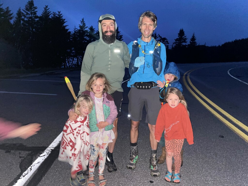
For whatever reason both Foster and I remembered the Mitchell summit trail as being 5 miles long. We quickly learned from the 1/2-mile informational posts that it was in fact 6 miles. Well then. We debated filtering water from the South Toe River at the base, but both remembered the Mitchell climb having lots of water on it. Here we both broke out the headphones for the first time on the route. Try to get in the zone and pass the time. We kept a slow and steady pace for the entirety of the climb basically. There were no crazy moments or anything wild, just moderate consistent progress. Gosh the .5 mile markers felt like they were spaced too far apart. Passed several groups of hikers coming down the Mtn, as it was a little past 5pm and getting late in the day. I remember just wanting to see some spruce/fir trees as that would mean we were getting close, well closer to the summit. Found a marginally acceptable water source and filtered what would be the last water of the journey. Full of moss and dirt and leaves and everything. But water. I was down to one Ziploc of Skratch gummies as the sole sweet option. They were ok, but nothing was really great at this point. Started feeling slightly dizzy so I threw everything I could at putting some food down. Jerky, chips, those gummies, Skratch mix. I was feeling real gratitude for the chance and ability to make the journey that we did, and feeling proud about what we were about to complete. Here we are at the Fir Forest! Winds were picking up and getting downright chilly honestly. Some cool looking campsites dotted right along the trail. Boom, another .5 mile marker. Tic Tac with the poles, step up step around, switchback. Crossed the power line for the first time, another benchmark of uphill progress. Some of the power line crossings provided an amazing view back east towards Table Rock, which we could identify in the distance. It looked very distant. Foster and I both viewed and took pride in moving across all that terrain, plus another 47 miles before Table Rock. Somewhere along the climb we discussed how we might respond when someone asked us “How was your run?” It seemed impossible to give an answer that could convey what we both just experienced. Sun was waning, winds increasing, temps dropping – we both put on our Airsheds somewhere along the way. Eventually we reached the Buncombe Horse Trail intersection - now we are getting close! Lauren called – her, the kids and Foster’s family were at the top waiting for us. We can’t climb this last section fast enough. It was getting dark enough in the forest that I rummaged around for my Kogalla waist light to illuminate the last few moments. Finally through the last .5 marker, the trail almost mellowed out a bit, crossing some very rocky crag-like areas, then started passing some informational kiosks – those signs are a good sign! Darkness creeping on us fast now, the trail finally opened up to the cobblestone walkway, we busted out of the dark forest and both broke into a sprint – a full-on sprint for the final few hundred feet to the top of the Observation area at the Summit. Right at last light, we were there, we were done. Stopped the watch and saw mileage read 99.84. Our families weren’t at the summit but there were several people up top, some asking us if we were part of the race (as Hellbender was going on that same day but had already wrapped up). We told them we weren’t, they asked where we started from, to which we proudly declared “Grandfather Mountain”.
We celebrated together briefly before hobbling down to the upper parking area, so ecstatic to have succeeded in our goal. Lauren called again; she had expected us to come out via the Crest Trail, so everyone was down lower. We slowly made our way to the families, greeted them with wide smiles, hugged everyone, snapped a couple photos, and hopped in our vehicles to head back to normal life. Outside temp reading was 43 degrees, I knew it was chilly! Everyone seemed ready to get in the car and leave. A surreal and very brief ending to a long, difficult, and amazing route.
After being distanced from the experience for a while, many of the more difficult and frustrating parts have been either forgotten or remembered in a sugar-coated kind of way. But all in all, it was an incredible adventure to be a part of, and the training, logistics planning, and execution ultimately came together well. It is a beautiful route that has special meaning and significance for me, and I am so proud to have been able to make it happen.