


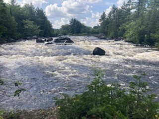


In short, the Maine section of the International Appalachian Trail was a challenge, crossing the line from Type 2 to Type 3 fun. When I submitted the route, I’d assumed it would be an easier extension of the well-traveled Appalachian Trail and would be similar in character. The elevation profile is mild, and appears to be a seemingly fast mix of road and trail. In reality, the Maine section of the International Appalachian Trail is a crazy mix of road walking, ATV trails and bushwacking. The road walking sections seem endless (stretches of 26 miles and 15 miles) as do some of the ATV paths (30 miles from Houlton to Mars Hill on a multi-use railroad bed). A roadrunner would destroy these flat sections in an FKT attempt. Though, interspersed are patches of trail that require route finding and tolerance of knee-deep bogs, bugs, tall brush and seemingly unmaintained, insect-dense trail. One common in the FarOut app labeled the trail sections as “guided bushwacking.” I couldn’t have described it any better. The IAT is also a lonely affair; I encountered no other hikers and saw only the footprints of moose and deer.
The bipolar nature of this route tested me mentally and physically. The road sections were mind and body numbing while the bushwacking was anxiety-inducing and physically exhausting. My feet and lower legs were destroyed by the end, a vicious combo of constantly wet shoes, flat pavement and minimal cushion trail runners. Blisters and swamp foot for the win, LOL.
Logistically, I completed the IAT Maine section solo and self-supported. I carried all of the gear and food I needed, but did stop at little camp stores for bonus food, soda and human contact; I also visited at a little maple syrup shop for water during a lengthy 26 mile road walk with few safe, natural water sources. All flowing water seemed to be agricultural run off.
I navigated using my Coros watch, the FarOut app, and a GPX file in Gaia. It seems like an overkill, but I honestly feel like I needed all these resources during the minimally marked trail sections. Using the maps/route feature on my COROS helped me save battery life on my phone. I left it on the mapping screen for peace of mind during long, unmarked sections.
The route started at the Canadian border at US Customs Station in Fort Fairfield, Maine. As recommended, I had contacted the border agents in advance– their radio room needs your description and times of travel. They will see you on camera as you hike. Despite this, the start was a little rough. My husband and I didn’t know where to park at the station and accidentally went into Canada (big whoops). Canadian customs asked for our passports and then let us U-turn. US customs decided that our big, white, Dodge Promaster camper van with NM plates was a little sketch and potentially needed to be searched. We tried to calmly explain that we had been in Canada all of 2 minutes and couldn’t find the IAT trailhead. The agent didn’t seem to know the IAT existed (he was new) and proceeded to open all our doors and survey all with suspicion. Eventually his supervisor seemed to step in and indicated he should just let us through; we were given permission to park in the US station lot for a limited time. Relieved, we quickly parked, and I hurriedly put water in my bottles and grabbed final snacks. Neither my husband Jeff nor I wanted to hang out there any longer than needed. I said goodbye to him and our trail dog Gracie, started my Coros and Garmin and took off running…
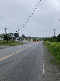
The first stretch of 3 miles was on road and/or mowed grassy “sidewalk” beside the road. I got up close and personal with potato fields and incredible yellow birds. The river of pre-trip anxiety flowed away as my body started moving and remembering the feeling of a solo, FKT adventure.
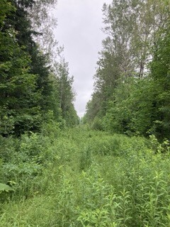
Next came the Border Trail section, otherwise known as the “slash.” This is basically a 10 ft swath of clear cut no-man’s land between the US and Canada. The “slash” alternated between runnable 2-track and unmaintained trail with waist high brush, bogs, and streams. The “trail” undulates for 14.5 miles along this Border trail. At one truly low point, I stepped on some moss and sunk to my thighs in mud. Praying my shoes stayed on, I managed to pull myself out of the muck and crawled out on all fours to avoid sinking again. While on the Border Trail, II kept myself entertained looking for US and Canadian border markers as well as cameras and sensors.
After 14.5 miles, I passed my last border fence and started a road walk toward the community of Mar’s Hill. Right as I was about to leave the road for another trail section, a US Customs truck pulled over beside me. The agent rolled down his window and cheerfully stated, “I’ve been looking for you for a while.” I had tripped all their sensors, and it took him all morning to catch me. He commended my pace and sent me on my way with a big smile and wish of happy hiking/running. My faith in US Border agents was restored.
The Border Trail section was a novel trail hurdle and interesting to experience, though I do not feel the need to hike the “slash” again. Calling it a “trail” is definitely a stretch.
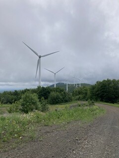
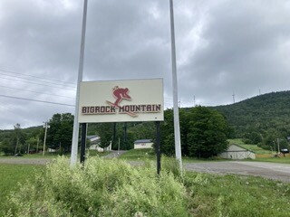
Next was a short section of bushwhacking guided by blue flagging tied around tries. It slowly climbs up the backside of Mar’s Hill and is entirely within a wind farm for about 5 miles. The trail then transitions into gravel service road. I really enjoyed walking/jogging uphill under the giant turbines and was calmed by their creaking songs. Eventually, the ridge line crested at the top of the Big Rock Ski Hill, and the trail heads downslope. This was something I had trail run prior, so it was really nice to be in familiar territory. The ski hill transitioned to 2-mile road walk to the bustling community of Mar’s Hill. I made it here around 2pm, perfect timing for a pick-me-up Dr. Pepper and a little bag of BBQ chips at their community IGA. I had contemplated doing this route unsupported but acknowledged how nice a quick soda stop in a small community can be for morale and blood sugar.
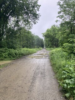
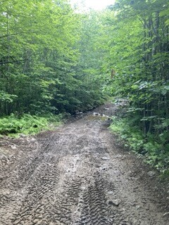
At this point, I started my long-term relationship with the Southern Bangor and Aroostook Trail, an old railroad bed converted to multi-use trail. Utilized primarily by ATVs, it was especially busy over the 4th of July weekend. I encountered no other hikers but saw countless ATVs decked out with flags and patriotic LED lights. I was on this ATV trail until the town of Houlton, 29ish miles away. Options for both camping and water were limited as the trail is bordered by private property, bogs and beaver ponds. This section also started my battle with mosquitos. Toward the end of the day, my legs were worked, though I kept jogging to avoid the buzz and bites of black flies, mosquitos, and deer flies. It had also started to rain steadily. At mile 41, I stealth camped behind a closed restaurant. Wet and cold and sore, I ate a package of Ritz peanut butter crackers and called it a night. For a road runner, this flat section would be lightening fast, but, for a slow trail runner who avoids roads and wears Lone Peaks, this section was brutal for my shins, knees, and feet.
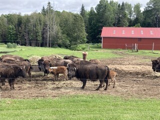
Up early the next morning, I continued on the rail trail/ ATV trail for 10 miles to the booming town of Houlton, the commerce center of Aroostook county. The IAT walks directly past a large Hannaford’s grocery store and a Dunkin’ Donuts. This was a major boost in a long day to come. After a deli sandwich, triple cream-triple sugar dark roast coffee, and new bottle of insect repellant, I was on the road again, literally, for the next 26 miles. This is where I lost my shit and nearly quit. A marathon on the shoulder of busy roads isn’t my normal wheelhouse. I listened to podcasts, I listened to music, I called my mom and husband, texted my best trail running buddy, and I lamented my fate, focusing solely on how much my feet hurt. I contemplated hitch-hiking to my car when I crossed over I-95. But, somehow I kept walking and running downhill when I could. The game-changer for the day was a phone conversation with my thru-hiking bestie and triple crowner Flow. He agreed that my day sucked and then shared the amount of road walking he did on the CDT, especially in New Mexico. This changed my mindset. Flow walked hundreds of road miles on the CDT and didn’t quit. I could make it through this day. I also recognized that my husband and I had shuttled my car over 2 hours down bumpy gravel roads so I would have it at the end of the trail; I was pretty sure he wasn’t going to help me get it back. So, my attitude changed, I embraced my road time. It also helped that it started to get quite hilly. Time passed quickly with the challenge and stimulation of ups and downs. I guess flat roads are my Kryptonite. The long road section had some highlights too– Relatively few bugs, cool farms to look at, Amish guys riding past on bicycles, families in horse-powered buggies, buffalo farms, strawberries, interesting rural businesses. A downfall of a busy road walk– no water and no place to pee. 20 miles in, I stopped at a maple syrup shop; the gracious owner filled my bottles and let me use her bathroom.
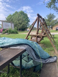
I pushed my miles into the late evening because I literally had no place to camp; everything was private property along the roadways. I finally made it to an ATV path as the sun started to set and pitched camp along an abandoned logging road. I fell asleep to the sound of far-off fireworks and the glow of fireflies.
Dawn arrived at 4:30am, and I was up and already packing my gear. My legs and feet were throbbing all night, so sleep wasn’t so great. I was also jazzed that I was down to 58 miles. Deep down, I hoped that I could make it back to my parked car and the end of the trail that day. Odds were not in my favor, but a girl can hope. My spirits were high, and I also realized I had 3 tiny stores along my route! 10 miles or so of muddy ATV trails started the day. They rolled by pleasantly, and I found myself running all the downs and some of the flats and enjoying the views along the way. I ran into Sasquatch (see picture) and he reminded me it was the 4th of July. The ATV trails ended abruptly at the Wilderness Variety Store on the paved Shin Pond road. In front of the store sat 6 old gentlemen drinking coffee. When I rolled up, they made the comment, “Sure are a lot of women hiking the trail this year.” This was a surprising statement as I had seen no other hikers nor footprints (besides moose and deer) the whole trip. Literally minutes before, a female hiker had been at the store. She had gotten a ride ahead to the entrance of Katahdin Woods and Water National Monument to avoid the next road walk of 17 miles. I guess she had killer blisters. Leaving the old Maine gentlemen to their coffee, I checked out the little store and chatted with the owner. She was kind and friendly. I got a milk and sugared coffee to go and continued down the road to another camp store (.5 miles away) where I used the wifi to check in with family and picnic tables to dry out my wet tent. The tiny slice of civilization (and hot caffeine) was like rocket fuel; the road section was transformed into a chance to make miles rather than an obstacle.
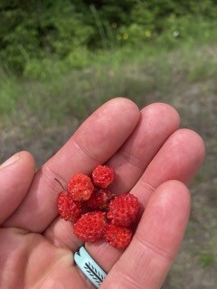
This Shin Pond section of road was more remote than the road experience of the day before. Few houses and few cars besides tourists and river shuttles, it ended at the gates of Baxter State Park and the Katahdin Woods and Water National Monument. Curvy and rolling, it offered opportunities to power walk ups and run downs. I also was treated to bountiful wild strawberries, beautiful patches of lupines and daisies and the coldest piped spring. It’s the little things that keep you going in a big adventure.
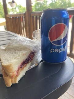
The day got warmer and sunnier and the road walk a little tougher as the asphalt heated up. I finally arrived at the end of the road and my final camp store. This meant I had 30 miles of trail and monument roads to the finish. At the Matagamon Wilderness Campground, I took a quick break, filling my water bottles and celebrating with a Pepsi, chips and divine PB&J on homemade bread. Though delicious, I could only stomach ½ of the sandwich and wrapped up the rest for dinner.
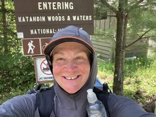
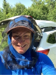
I said goodbye to the awesome owners of the campground/store and began my final leg. Crossing into the Katahdin Woods and Waters National Monument at the Matagamon Gate, I made contact with the park ranger I had met days back when my husband and I dropped off my car at the trail’s start/end. She was surprised to see me and I was happy to see her, a familiar face. The park started with easy gravel roads but the bugs were pretty bad. Finally, it was time to wear a head net full time, evening while running; the gnats and black flies were making it to my face despite a year’s worth of DEET sprayed any exposed skin. The insects proved to be a major obstacle for the rest of the route, I needed a headnet constantly, even in the pouring rain that was to come.
Time on gravel road was short, and soon I was jogging down winter ski trails. Eventually, I made it to the East Branch of the Penobscot River and a series of campsites for boaters. The trail conditions went downhill from here—boggy, brushy, wet and slow. Thunderstorms also arrived. Chances of finishing tonight were low, so I went to Plan B– the Lunksoos Mountain Lean-to 12 miles from the end of the trail. Even getting to this point was tough, the storms continued, and despite being built on an old road bed, the trail got harder and harder to find in the deep brush. I was panicked at the thought of bushwacking in the dark in this remote stretch of park. So, I moved as fast as I could. Mosquitoes also helped to motivate my rate of travel. They were so bad I couldn’t even bend down to tie my shoelace without them swarming my hands and face. Yikes! I needed my headlamp the last mile, but made it to the shelter right as the sky opened up and a truly torrential downpour began. I dumped my wet gear and surveyed my home for the night, nice and dry but incredibly buggy (no surprise). I pitched my little Plexamid inside the shelter (titanium shepherd hook stakes fit magically in floor gaps) and hung wet things to dry as much as possible. Then, I dove into the tent, put on warm clothes and listened to rain as I shoveled down the rest of my sandwich. It tasted even better after 17 miles.
The rain continued throughout the night. I didn’t sleep well… I was excited and anxious about getting the last 12 miles done. I knew my final obstacle was a river ford ½ way through this distance. The night's rain added even more water to already swollen streams. Despite my anxiety, I needed to stay put until first light as I needed some natural light to make it safely through a few more miles of bushwacking through brush and alder thickets.
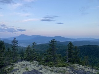
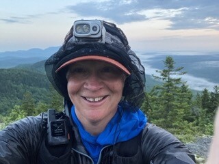
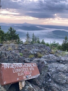
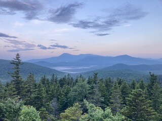
Up before 4am and my alarm, I packed my gear in the dark. I started off with a headlamp to supplement the low light provided by overcast skies, but within 30 minutes, things were a little brighter. The early morning started with climbs up 2 mountains (Lunksoos and Deasey) and best views of the entire trip. Fog shrouded the valleys while the mountains, including Katahdin glowed in the morning light. Hard earned, it was one of those moments on an FKT when you say to yourself, “Fuck yah, I did this!”
Though beautiful, the morning terrain and route finding contributed to some of my slowest miles of the trip. The trail down from Deasey Mountain seemed to be a little more traveled, so my pace picked up. I made it to the river ford after an appetizer of walking through a knee-deep beaver pond. At that point I was soaking wet, so I plunged in without even considering taking off shoes, socks or rain gear. The current was thankfully not strong, but the river went to my waist at the deepest. I moved slowly and carefully and made it to the other side without incident. I exhaled and realized I was going to finish despite many obstacles.
With 5 miles left, I navigated another old, overgrown road bed and ran when I could. It was surprisingly wet for a while– at one point a family of ducks was paddling down the trail (not joking) but nothing was going to stop me. The end, my car, dry clothes, a soda…. All were waiting for me.
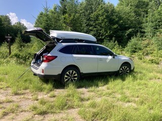
The roadbed climbed steadily uphill, and the sun came out. I encountered a lot of snakes in the last few miles and listened to an inspiring podcast about a badass woman who hand cycled to CRT in under a month; both kept my adrenaline and motivation high. I ran past the Barnard Mountain trailhead and then the Katahdin Stream lean-to and realized I had only .5 miles up a small hill to the finish. Finally, I saw my car and the end of the IAT. Holy shit! I hit stop on my Coros and Garmin and punched the air. My Subaru hatch opened (thank god I didn’t lose the key), and I was reunited with clean clothes and flip flops. The remote trailhead was empty and miraculously bugs were gone, so I stripped right there and put on my town clothes. Soda and chips in hand, I sat in the driver’s seat and looked in the mirror. The woman who looked back was dirty and bug bitten but had a big smile across her face and a glow of exhausted accomplishment.
I honestly didn't think I would finish this one, and it made the end all the sweeter. The IAT was hard. I cried on an endless stretches of road. I screamed when the trail dissolved into bogs and alder thickets yet again. I maniacally swatted swarming mosquitos from dawn until dusk. I lost my shit and found it again. As I reflect a few days after finishing, I realize how vital this hard, solo FKT stuff is to me. Life is sweeter, and the sky is the limit once again.