We started out of White City a little after midnight on Friday, December 9th, walking through the campground up to the Guavo Road trailhead. From there, it was approximately 3.7-4 miles to the visitor center, which is where previous FKTs had started/ stopped. We had read on the FKT site, however, that the official route started at Guavo and wanted to include this extension.
Our anticipated completion time was between 14-16 hours. We expected the majority of the route to be on more cruisy singletrack/ roads that we could maintain a steady shuffle pace on. Our expectations were quickly shattered after we finished running the road on the Carlsbad side. Between approximately miles 10-22, we were bushwhacking through dense cactus and thornbushes on a very broken “trail” that had clearly not been traveled on for quite some time. This was both mentally and physically taxing. Had it not been for the map downloaded on Chris’ Coros watch, the route would have been nearly impossible to navigate during the night. While Chris was wearing tall socks, Erin was not and her legs got very scratched up, causing discomfort for the remainder of the effort. Fortunately, we did not encounter any mountain lions in the night but did cross paths with 3 skunks.
By the time we reached the jeep road around mile 22 (end of Carlsbad NP side), the sun had begun to rise and our spirits were feeling higher. We put on some music and got some faster miles in, though anybody considering this route in the future should know that the road consists of uneven cobblestone, which presents a high risk for tripping. Erin tripped once on the road. No injuries were sustained but this was a low point for her mentally. We shared a Yerba Mate before exiting the road portion of the trail, which helped to elevate our spirits, albeit our hip-flexors were feeling tight for both of us from the awkward road running cadence.
As we cleared the forest, the skies also began to clear and the route turned into a singletrack trail. We were able to see spectacular views of Guadalupe NP along the ridge. At this point begins the first major descent of the GRT. The trail is even more cobbled here than on the road. Chris’ right foot began to bother him here. We saw several bighorn sheep, which was a cool treat. Temperatures rose significantly as we dropped down to the McKittrick Canyon visitor center. We decided to make the extra detour and go to the visitor center for about 10 minutes to use the restrooms, refill on water, and rest our feet.
After the visitor center, the trail is a flat cobblestone track for a few miles before beginning the first major climb. The views looked more like a jungle landscape than something you would expect in west Texas. Erin was feeling decent at this point, but it was evident that Chris had entered the pain cave. Although the mountains were breathtaking during the steep climb, we were both mentally and physically drained from a day that was taking much longer than expected. The climb up felt endless (and this comes from two people who love vert more than anything). There is a neat cave you pass on the way up, which is something others should look out for.
Once we reached the forest at the top of the climb, we stopped for a couple minutes to discuss the concerns about pushing into the night- headlamps low on battery, low on calories, low on water, etc. We also drank a NOM drink mixture, which rejuvenated us for the remainder of the descent before sunset. Surprisingly, our legs felt good enough here to put in a few speedier miles. At sunset, we had service and hopped on the phone with Chris’ dad to inform him of our whereabouts and options for the remainder the traverse. During the final cobblestone switchbacks leading to the Guadalupe visitor center, Chris was leaning towards not finishing the final climb up Guadalupe Peak due to potential injury in his foot. Although exhausted, Erin was committed to making it to the end of the traverse. We decided to make it to the visitor center and evaluate there.
Upon arriving at the visitor center, we retrieved a bin where we stored extra gear, food, and water. Originally, we intended for the effort to be unsupported and to not get the bin until the traverse was completed. We decided it would not be safe to proceed the final climb up Guadalupe without resupplying, thus making it a self-supported effort. Chris hopped on a phone call with Jason Hardrath at this point, asking for advice on what to do. Because we only had a little over 4 miles and 3,000 feet of climbing left to the top of Guadalupe, we knew we would regret not finishing after all we had been through. In the back of our minds, we also knew that we had a surplus of time to work with. Even if the climb up Guadalupe was slow, we would still shave a significant amount of time off the previous records. Furthermore, because the FKT route ended at the top of Guadalupe, we also knew that we had the option to bivy up there if we were too fatigued to hike down that night.
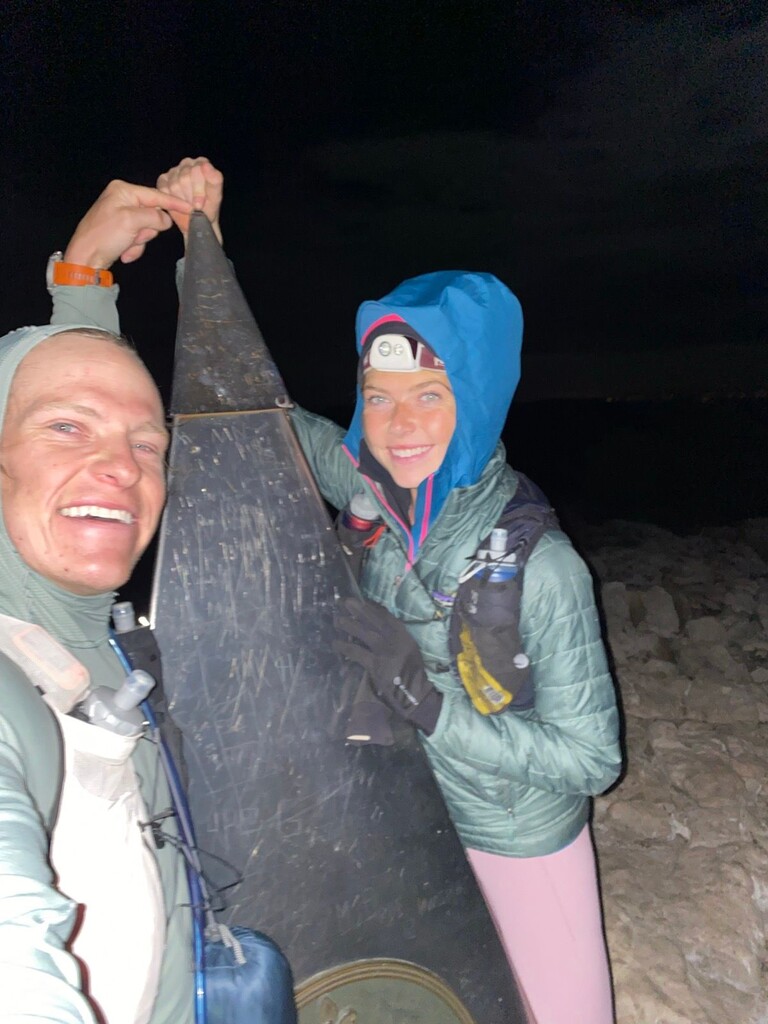
The decision had been made, and after we got our packs together, we hobbled out of the visitor center and campgrounds. Once we got moving again, some of the soreness in our feet began to wear off and we were moving faster than expected. The trail up Guadalupe is highly trafficked and therefore in great condition for more cruisy miles. The full moon was also out, making it so that headlamps were unnecessary. We reached the summit of Guadalupe before 11pm, completing the traverse in 22 hours and 33 minutes. This makes it the first known sub-24 hour completion of the route. After snapping a couple quick pictures with the summit marker, we found a spot shielded from the wind to bivy for the night. Ultimately, because of the cold, we only spent 4 hours up there trying to sleep before hiking down that night. We rested for a few hours at the visitor center before sunrise. Our efforts to hitch from Guadalupe back to Carlsbad where the truck was parked proved fruitless. Thankfully, Chris had staged his bike at Guadalupe and made the 35 mile ride up to the truck. He then went to retrieve Erin and the two drove exhausted and hungry up to Carlsbad for milkshakes and fries at Becky’s. Highly recommend.
Summary/ Conclusion paragraph
Would we recommend this route to others? Yes, but wait until the trail on the Carlsbad side is cleared. According to the park service, this should be done around spring 2023. Once this occurs, there is the room to shave off hours from the record. Moreover, others considering this route should also choose a time when it is not too hot outside.
Comments
Great time, but the official route was not followed. Like many people who hike the GRT, these hikers stayed on the 201 above Agua Dulce Tank, shaving 1.93 miles and around 1000' up/ 1000' down off of the official route. Check the official route map on the NRT database for verification.