So it turns out I can’t count. When I finally decided to tackle this monster part of what appealed to me was that I could bag 14 peaks along the way. That seemed like a fitting follow on to completing 13 peaks in Cape Town in 2021. But when I sat down after all the dust had settled and went through the selfies I took on each of the peaks and counted them I realized 14 peaks had somehow turned into 16.
I blame Ian. He was the one who sent me a write up of something called Cove to Cove. I’d been casting around for a race or goal for the year but nothing really grabbed me. After reading the write up I had a sinking feeling I was hooked. Sinking because the route they were describing was slightly crazy, and I had planned on making 2023 a recovery year after tackling the WAM 100 the year before. The best laid plans and all that.
The course itself was going to be really tough. It covered about 90km, around 8000m of climbing, and some ridiculously technical trail (most of the North Shore seems to be designed to help you plant your face in the mud). But what I really had no idea how to think about was spending the night in the North Shore back country. I’ve done plenty of overnight running before, but it was either under the watchful eye of race marshals, or in a place where the wildlife was slightly more tame and was something I felt like I had a handle on. The back country here has coyotes. And bears. And cougars. And while I’ve had a few encounters with coyotes and bears I had no real idea how likely I was to encounter them at night, or how they were likely to behave if I did. And cougars? I suspect by the time you see the cougar its too late. I had also rolled my ankle a couple of weeks prior and while it was feeling mostly recovered I was a little worried it would blow up under pressure.
Support was going to be a challenge. The second half of the route was completely inaccessible by car and the only points where I could feasibly meet people required either hiking or cycling out to meet me. Fortunately I have people who either love me enough to do that, or at least who need me alive enough to be willing to put up with this silliness. Timing would be tricky because it didn’t help if I came through one of the stops where someone hiked out to me in the middle of the night. So the plan was to stop and try to sleep if I needed to shift the timing. Fortunately I hit my timing pretty much bang on so the whole plan mostly held together. Communication would also be a challenge because there’s not a lot of cell reception in the back-country, so I’d be using a Garmin inReach Mini to publish my location every 10 minutes, and to send and receive messages. I kept expecting locals to try to talk me out of it, but no one did. In retrospect I half suspect I projected enough (unwarranted?) confidence so that everyone just kind of assumed I knew what I was doing.
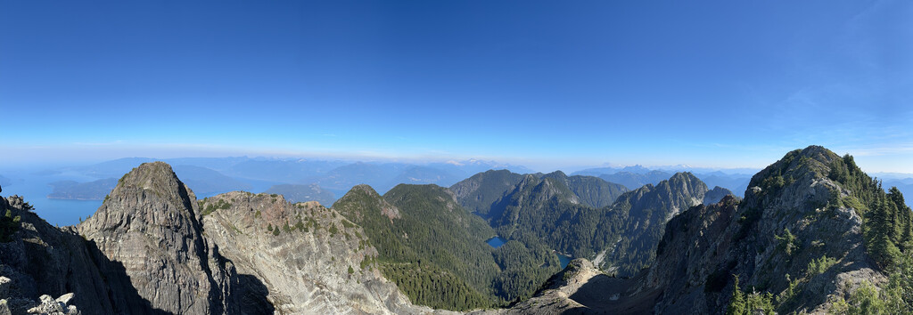
The actual “run” went well. Between the elevation changes and the technical nature of the route there was way more fast hiking than running. Claire and headed out to Porteau Cove at 5am to be ready for a 6am start. After a couple of kilometers on the highway I finally got onto the start of the Howe Sound Crest Trail (HSCT). The first 15km is a slow climb up to Brunswick Mountain, circling Deeks Lake, Hanover Lake and passing Brunswick lake. It’s a really beautiful stretch. Brunswick itself is the highest mountain on the North Shore at 1788m, but you tick off a lot of that elevation slowly as you make your way up around the lakes. The view from the top is pretty spectacular. I’d forgotten how much scrambling there is at the top (it’s not crazy hard but it’s definitely not for anyone with a fear of heights).
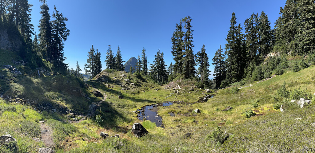
From Brunswick you pass through Magnesia Meadows, which is a favorite spot for camping (hikers will often do the HSCT over two days). There’s a marvelous outdoor toilet here with a view to die for. It’s the most Canadian thing I think I’ve come across so far.
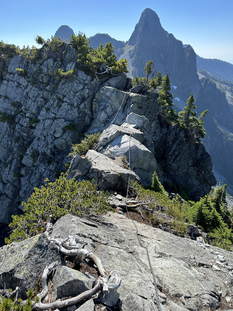
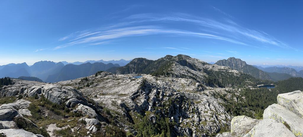
When I think of the HSCT I think of up-down-up-down. You’re following a ridge-line technically, but you continually throw away elevation only to have to climb to get it back. I also think of technical trail, especially around the pair of Unnecessary mountains. I think they are named that for exactly the reason you’d expect: every time you hit them on this route they feel totally unnecessary (like why spoil a good trail with these two bastards?). On this section of the Cove to Cove route you traverse David Peak (1480m), James Peak (1466m), Thomas Peak (1540m) and then you pass through the two Lions before encountering Unnecessary Mountain (1548m) and Unnecessary Mountain South (1548m) and skirting Saint Marks Summit (1371m). From here it’s “all downhill” (hah) to the Cypress Ski Resort parking lot where I met Ian and Claire for some food and a failed attempt at some sleep before getting kicked out of the parking lot because the gate was closing an hour earlier than we thought.
Onwards. Passing through Hollyburn I came across a “bear activity in area” sign with a “last sighting: 10/25” at the bottom. That was only a week earlier, and the sun had just set, so this was my first leg in the dark. That sign was not the kind of reassurance I needed. But I knew these trails pretty well and felt a little more comfortable as a result. It didn’t take long to get to Cleveland dam and from there it was a short 2km hike up to the Grouse Mountain parking lot where I met Claire for more food, a top up and a lie down. Sleep remained elusive but taking some weight off my feet felt marvelous. We obviously looked suspicious because some of the Grouse Mountain staff came over to find out what we were up to. When Claire explained that I was doing a run through the mountains they asked if I had safety gear and then basically said “ok, be careful, have fun” and just left me to it. Another missed chance for the locals to inject some sanity into this situation and instead they cheerily set me on my way. There is something very Canadian about casually heading out into the wilderness for the fun of it.
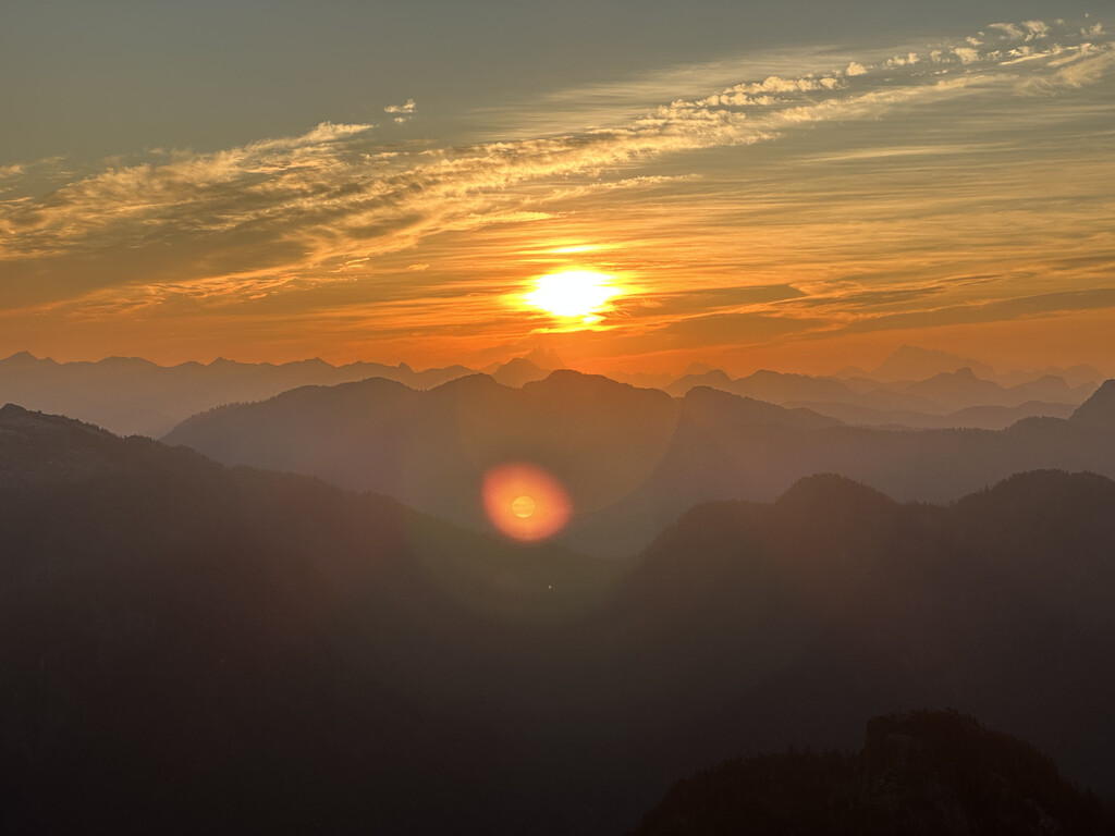
This was the leg in the dark I was most anxious about. I figured if I was going to bump into wildlife anywhere it would be between the Grouse Mountain chalet and Crown Mountain. I have no really good reason to believe that, just that in my head that was where I pictured rounding a corner and bumping into a bear. It was also the first time I’d try sleeping in the back-country at night. I had the Outdoor Research Helium Bivy in my pack and I was going to test drive it for real on this run. I found a flat clear spot almost literally on the top of Dam Mountain (1349m) and decided to stop there. Setting the bivy up was pretty simple but once I was inside it was like every mosquito on the North Shore wanted in as well and I swear I could hear them ricochet off the tent wall. And they sounded big. And mad. I think I’d have preferred the sound of a bear sniffing around outside my tent at that point! Between that and cooling down because I’d stopped moving sleep proved impossible. So I gave myself about an hour to lie down and then packed up and headed out. That was at about 3:30am and I figured it left me enough time to get to the top of Crown Mountain in time for the sunrise. The route to Crown Mountain passes over Little Goat Mountain (1323m) and then drops down a couple of hundred meters to a saddle before ascending up to the peak of Crown Mountain (1504m). Crown is the highest peak visible from the North Shore and the view from the top is spectacular. I managed to make it just before sunrise so I got to watch the sun come up from the top of Crown, which is something else. Against all odds I had cell reception on Crown and so I got to share the sunrise with my support team as it happened.
Nutrition had been fine up to this point but here my stomach started to give me some hassles. That’s pretty unusual, I’ve only had nausea once before and I was using the same nutrition that had worked well for me through WAM. So it was a bit of a surprise and meant an already challenging run was going to be harder. But nutrition never really turned into a problem. I think that is mostly a result of the amazing support I had and the sheer volume of watermelon, soup, potatoes and myriad other kinds of real food everyone carted out for me in backpacks and on bicycles. I also found snacking on huckleberries, which were still plentiful in the mountains, helped a lot. I was worried about water going into the run because most of the route is pretty dry by now, but that turned out to be totally fine. Timing helped a lot with water because I was overnight on the driest stretch.
From Crown it’s down into Hanes Valley which is a slow, tricky descent through a loose rock field that just never seems to end. But I started passing people at this point, and it was only a couple of hours from here to just after Norvan falls where I met Claire and Tracy for more food, water and a bit of a rest. I was extremely warm anytime I was moving, but when I stopped I quickly cooled down and Tracy hauled out an emergency space blanket and wrapped me in it. A side effect of that was every single person who passed stopped and asked us if everything was ok, and at least one person offered to hike back and call help. Tracy shooed them all away with a word that Canadians seemed to understand immediately: “race!” but it was amazing how helpful everyone tried to be.
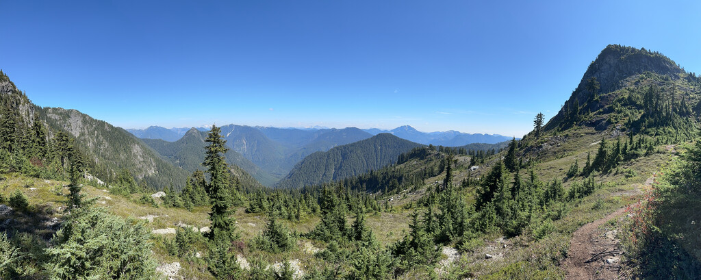
Next up was the climb to Coliseum Mountain (1441m) which feels like it will never end, and gets pretty technical as you get higher up. It also teases you with anywhere from 3 to 5 false summits, including one that is followed by a pretty significant elevation drop which you then need to regain. But it’s one of my favourite peaks on the North Shore because it looks so different to the other peaks. It’s like a moonscape at the top. The descent from here into Seymour valley is just unpleasant. There’s almost nothing good to say about it. It’s super steep, super technical, and even the detour out to Paton Peak (1057m) isn’t particularly pretty. But once I was down at the bottom I only had the climb up to Vicar Lake and Vicar Ridge before I was “basically” done. I met Ian at the bottom for more food and a rest. We timed it a little badly and I ended up waiting a bit there but the rest was honestly welcome. And it came with a portaloo and a nice flat bench to lie down on so I had nothing to complain about.
I left Ian as it was starting to approach sundown, which meant doing the climb to Vicar Lake in the dark. It’s a pretty scrambly, technical climb, with a lot of route finding, which is even harder in the dark, so it was pretty slow going. I have always been intrigued by people who report hallucinating during long endurance events like these. I am disappointed to say that I have not yet experienced full blown hallucination (and from what I’ve read you are either someone who does, or someone who doesn’t). But I definitely started to see things out of the corner of my eye, and my brain would map shapes onto something improbable (like the bulldozer on top of the big rock). I almost took a photo of a really cute chipmunk that turned out to be a tree root. I never experienced anything that was a clear hallucination that persisted when I looked closely at it, but my brain’s pattern matching was definitely in overdrive. Climbing up to Vicar Lake was quite surreal. The whole way up I kept waiting for the person behind me to catch up, before remembering that there was no one behind me.
From Vicar Lake it’s a “straight” ridgeline to just beyond Mount Seymour. It’s pretty technical and there’s a lot of route finding, so it was slow. It also shares the up-down-up-down quality that anyone familiar with the HSCT knows and loves. You hit Vicar Peak (1247m) first, traverse across to Curate Peak (1266m), and then on to Rector Peak (1270m). They’re all at roughly the same elevation but each time you leave a peak you drop down 50-70m and the climbs back up to the next peak are all pretty steep. After Rector you head over to the trail up to Mount Elsay, hang a sharp right and throw a bunch of elevation away again. And then you gain it all back (and a bit more) to get up to the Mount Seymour trail. Once I hit this trail I knew I was good. I’d been waiting for this point since starting because from here I knew it was pretty straight forward to get to the Seymour parking lot and from there it was all downhill to Deep Cove and the finish. But I had two more (small) peaks left. I met Andrea and Brie below Pump Peak at around 3am. They had hiked out and set up camp to meet me as a I came through overnight and had the most delicious hot chocolate I suspect I will ever taste waiting for me. We climbed to the top of Pump Peak (1407m) together and hiked back to the parking lot, detouring briefly to walk up to the top of Brockton Point (1265m).
In the Seymour parking lot, just before leaving Andrea and Brie to finish the last 10km to the finish we bumped into one of the staff members at Seymour who also wanted to know what we were up to. He mentioned that he’d seen a bear in the area that day and again, instead of trying to talk me out of anything, he basically just said “keep an eye out, look over your shoulder every couple of seconds, and if you bump into a bear try not to spook it”. And then he basically just sent me on my way.
This last bit was some new trail for me and was supposed to be “runnable” downhill. Hah. I should have known better. It was a murderous, technical, rocky descent. And my ankle, which had so far managed the whole weekend largely unscathed, was the first victim. First because I rolled both ankles on the way down that gnarly descent. But damned if that was going to stop me this close to the finish. The last couple of kilometers of the Baden Powel trail felt like they would never end. I would have sworn I circled Deep Cove 20 times but I looked at the map afterwards and it doesn’t look like I did?
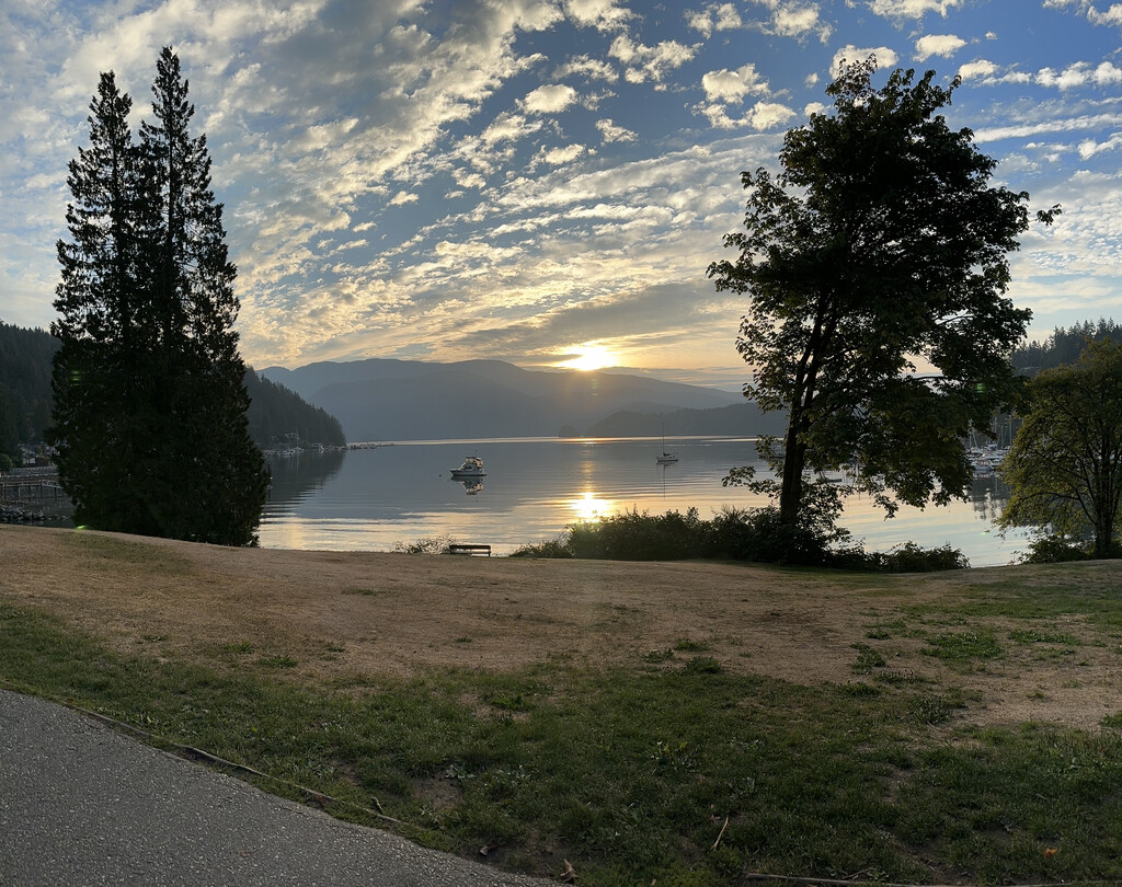
49 hours after starting out, running on fumes and zero sleep, I hit the water at Deep Cove to be met by Andrea, Brie and Claire, and a very welcome bench to sit down on.
This crazy adventure would not have been possible without years of investment from my running coach, Rebecca, multiple strength trainers and physiotherapists (hi David! hello Meredith! thanks Andrea!) and the support of friends and family. I am still kind of surprised no one seriously tried to talk me out of it, but I’m really glad they didn’t.