Jeff's trip was east-to-west. He coordinated the car shuttle with Faye Norby, who ran the women's FKT west-to-east at the same time.
Border Route Trail East to West FKT Trip Report
Start Time - 6:38 AM - 6 October 2018
Finish Time - 8:25 AM - 7 October 2018
Total - 25:47:20
Unsupported
Drove up to the East Trailhead at Otter Lake Road on the evening of October 5th through a steady rain, and lingering evidence of snow from the previous day. Car camped at the trailhead, and the alarm went off around 5:30 AM, luckily without any more rain falling. The logistics of this attempt meant that I would be leaving from the east side, while Faye drove to the West trailhead, and she would start her attempt a few hours after I began. After eating breakfast and checking and rechecking my pack, I started my GPS tracker, and my watch at 6:38 AM and started heading west on the trail.
I made it almost 0.25 miles before my feet started getting wet, and those same wet feet, socks and shoes stayed wet the rest of the run. About an hour into the run, I sent Faye a text through my Garmin to let her know that tree blow-downs seemed manageable, and the trail conditions were wet but not too muddy, as she would be starting and we would be without communication until we hopefully crossed each other on the trail 12+ hours later. I soon realized that my glove selection was a terrible choice as they started to soak through with water, and turn my hands cold. I had another pair of gloves in my pack, but knew it wouldn't take them too long to become wet and useless as well, so I decided to attach my trekking poles to my pack, and just keep my hands inside the sleeves of my jacket to keep them warmer.
12.6 miles in, I came to the McFarland Lake trailhead, and saw sunshine for 30 seconds while eating some leftover pizza and adjusting layers, and shortly after getting back onto the trail, entered the Boundary Waters Canoe Area, where I would be for the next 40 miles or so. The BWCA area of the trail is pretty remote, so very limited bail out options if things go poorly. There are also restrictions within this area on the use of motors, mainly for boats, but it applies for chainsaws as well, so I prepared myself to scramble over, under or around more trees for a while.
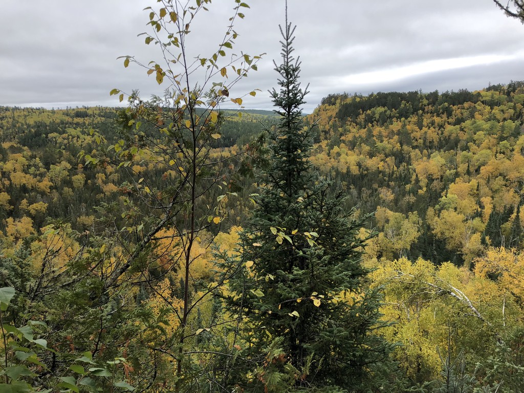
For the next 25 miles, the trail makes its way between lakes, through forests, up to the top of ridgelines, usually with an amazing overlook, and then back down the other side for more time in the forests. I came across three hikers who were staying at a campsite just west of the Mountain Lake overlook, and outside of them and Faye, they were the only people I saw until reaching the West trailhead.
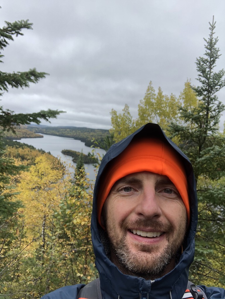
Around 6:30PM, and 35 miles in, I made it to the most runnable portion of trail, a 1.5 mile section which follows along a small stream flowing out of Rose Lake, and is the border between Canada and the USA. Around that time I also decided it was time to get ready for the overnight hours, so I put on my headlamp, and down jacket under my rain jacket which just a short time later a long climb to the overlook above Rose Lake made this seem like a bad idea, but I was able to adjust zippers and ventilation to not get too overheated. The overlooks on Rose Lake are some of the best views along the whole trail, but with sunset this time of year being around 6:30PM, the overlooks were just my headlamp pointing down into the abyss.
I saw a headlamp coming towards me around 7:30PM, and sure enough it was Faye on her West to East attempt. We spent a few minutes comparing notes on the miles behind us, and went our own separate ways. The trail continued the pattern of up - ridgeline - down - forest - up repeat for quite a while. Faye mentioned that the area around Bridal Falls where the Ham Lake fire from 2007 had quite a few spots where underbrush, and growth that was bent onto the trail made for a pretty tough slog. She certainly was not wrong, and when I got to that area, I spent the majority of it with my trekking poles being used for shield my face rather than stability.
I left the BWCA about 1:30AM and at 2:30AM I saw the first road since the McFarland Lake trailhead. This meant that I was getting into a fairly confusing trail area near some of the resorts that are in the area. The majority of the BRT is marked with blue flagging on trees, but when I got to this area, I found myself with my GPS in my hand most of the time to ensure I stayed on track. The last few miles puts you back on singletrack, with bare rock hilltops, using cairns to mark your way, with the 40 foot tall Magnetic Rock being the biggest cairn of them all, letting me know I had just 1.5 miles to the West trailhead.
As I got to the end, I met a backpacker who was going out for 8 days on the trail, and I think he had the right idea on the pace you should be experiencing this trail at.
Once I finished, I changed into dry clothes at the trailhead, and ate the last of my leftover pizza that was in the vehicle. A quick drive down the road to stop into one of the resorts for WiFi access allowed me to check in on Faye's progress, and a 2 hour drive later, I had made it back to the East trailhead in enough time to pick Faye up after her successful West to East FKT.
I did a pretty good job of eating, but was not doing a good job staying hydrated (I think I only had about 1.7L of water for the entire trip). I also decided that I would be done eating and drinking with 15 miles to go, again, a poor choice brought on by being tired and the single focus of just getting done. I think in dry conditions a sub 24 hour crossing is possible, but a lot of that depends on the trail conditions, temperature, and the amount of times the all volunteer trail maintenance crew has been out. I know I will be adding my name to the volunteer list to help keep this rugged and remote trail as passable as it can be.
Gear List:
Mountain Hardware SummitRocket 20L Pack
Mountain Hardware Finder Rain Jacket
Patagonia Houdini Jacket
Brooks Cascadia 12
Dirty Girl gaiters
Wrangler Performance Quick Dry Pants
PEP Shevlin Merino Wool long sleeve
Quick dry shirt
neck gaiter/buff
Down hooded jacket
Compression Shorts
Black Diamond FLZ poles
Homemade adventure/good luck bracelet
Garmin InReach Mini
Garmin Fenix2
Garmin Oregon 650t