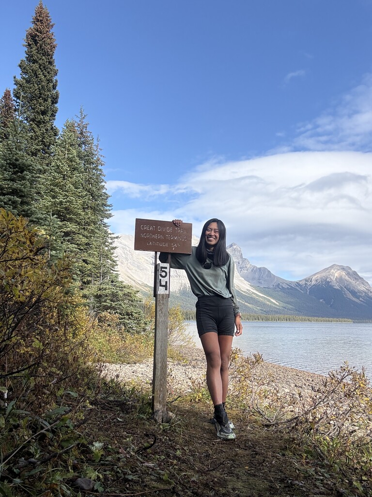
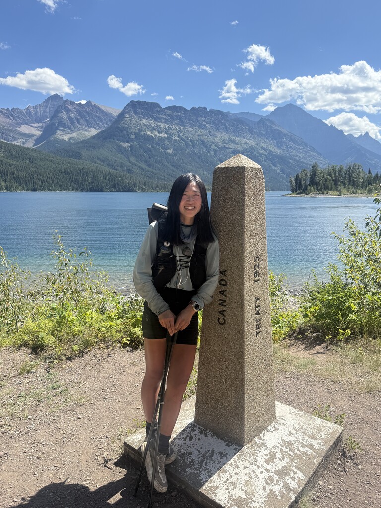
I started this hike northbound on April 21st, 2025 from the Crazy Cook terminus of the CDT at 9:51 am. I finished this hike on September 19th, 2025 at the terminus marker for the 54th parallel at Kakwa Lake at 10:40 am (almost exactly 152 days!). I reached the terminus of the CDT after 114 days and 3 hours with two zeroes in Breckenridge, CO and Lander, WY. I reached the terminus of the GDT after 38 days and 2 hrs 20 minutes, with one zero in Canmore, AB.
In my hike, I've attempted to set a 'first known time' as opposed to a 'fastest known time': I took advantage of scenic, more difficult, higher elevation alternates off the 'main' track for both trails. I also took some alternates that were known to be safer (e.g., quieter roads than the main highway roadwalk or lower routes) or that got me through a town instead of hitching to a town. I walked every roadwalk marked as part of the trails where it was needed to maintain a continuous footpath.
At times the conditions forced me to reroute around dangerous terrain especially in the snow, notably in Colorado when I was hiking alone in the Front Range. This was a low snow year in southern Colorado, yet I received 10 inches of fresh snowfall in a late-season snowstorm on my third day in Colorado and had to adjust. Much of my mileage in the Colorado section does not line up exactly with the red line as I cut up and down ridges and into valleys to find the safest path north.
Total Stats: In total, my mileage for the combined hike was 3,550 (5713 km) with 588,700 feet (179,450 m) of elevation gain. Of that total, 2,786 miles (4484 km) and 424,559 feet of elevation gain were on the CDT. On the GDT, my total mileage was 764 mi (1,230 km) and my total elevation gain was 164,141 feet (50,030 m).
---
Alternates: This is a full inventory of the named and self-drawn alternates I took, below, with the assumed impact to my mileage as compared to the red line where known. A notable alternate I did not take on the CDT was the Big Sky cutoff; I chose to hike through Idaho on the main CDT instead. A notable alternate I did take on the CDT was the linkup of three high routes that I did through Wyoming in the Wind River range, the Gros Ventre range, and the Teton range before circling back via a connected footpath to Parting of the Waters on the CDT, which added significant time, elevation, difficulty, and mileage.
You can see the exact .gpx tracks and each of my daily campsites in the folders on the Caltopo map.
Continental Divide Trail alternates:
- Gila River Alternate (-68.2 mi)
- Govina Canyon Alt (-1.1 mi)
- Pie Town Alt (-7.6 mi)
- Cebolla Alt (-35.8 mi)
- Narrows Rim Alt (equivalent mileage)
- Ghost Ranch Alt (-2.9 mi)
- Twin Lakes Cutoff (-7.4 mi)
- (Self-drawn) Silverton / Stony Pass cutoff (~ equivalent mileage but lower elevation): my hiking partner Slide was feverish for several days with intense gastrointestinal issues, so I mapped a lower route on forest roads towards Stony Pass to exit to Silverton. He ended up feeling better by then and we stayed on the red line from there.
- Frisco bike lane alt with Silverthorne / Dillon Alt (-46 mi)
- Mirror Lake Alt & Old CDT with Texas Creek ford cutoff (-1 mi)
- (Self-drawn) Vasquez Pass / Winter Park cutoff from Stanley Mtn jct (-13 mi)
- Rocky Mountain National Park cutoff (-17.2 mi): I wasn't sure I'd be able to get through the national park under the snowy conditions within a day and did not have a bear can to meet the requirements for backcountry camping in the park
- (Self-drawn) Grand Lake alt: unknown mileage impact
- Rawlins Highway Roadwalk - Sage Creek Rd (-3 mi)
- Riverview cutoff south of Lander (-5 mi): no trail on redline
- Wind River High Route (Skurka version with exit via Knapsack Col; includes Cirque of the Towers -- total mileage impact of WRHR, GVHR, and Teton Crest Center Punch was approximately +150 mi)
- Gros Ventre High Route
- (Self-drawn) Teton Crest Center Punch - modified with roadwalk exit
- (Self-drawn) cutoff to Benchmark Ranch (-6 mi, but I also walked the road to/from Benchmark Ranch which added 6 mi)
- Backtracking for Parting of the Waters (+30 mi, I think)
- Island Park / Mack's Inn Alt (-37.8 mi)
- Nicholia-Deadman Alt (+5 mi)
- Anaconda Cutoff (-85 mi)
- Spotted Bear Alt (-14.4 mi):
- (Self-drawn) Forest Service road cutoff to the highway before East Glacier (-9 mi)
Great Divide Trail alternates:
- Akamina / Mt Rowe - Sage Pass (-7 mi)
- Barnaby Ridge Alt (-1 mi)
- Rawson Lake detour (+2 mi)
- Kananaskis / Northover Ridge Alt (+6 mi)
- Kiwetinok Alt (+1.3 mi)
- Ensign / Amiskwi Ridge (equivalent mileage)
- Collie Creek Alt (-5.4 mi)
- (Self-drawn) Howse River Floodplain Fords / Glacier Lake Outlet Alt (-6 mi)
- (Self-drawn) Six Passes High Route Alt (equivalent mileage)
- Mt Robson side quests: Snowbird Pass, Mumm Basin viewpoint (+19 mi)
- Perseverance High Route with self-drawn exit to Jackpine River Valley, instead of standard Meadowlands exit (+5 mi)
- Surprise Pass / Wapiti Mountain (-0.7 mi)
Support: I received support as a normal thru-hiker would, in the form of hitchhiking as well as pre-arranged rides or stays and resupply / gear packages mailed or hand-delivered to me. I also accepted trail magic (e.g., snacks, drinks) when it was presented. I relied heavily on mailed pre-prepared resupply packages in order to ensure sufficient nutritional value. I spent at least a third of the trip buying locally. For Idaho and parts of Canada, I prepared resupply boxes myself and mailed them ahead or to friends. Some places in Canada I was able to find friends who bought my resupply for me and met me on trail with it.
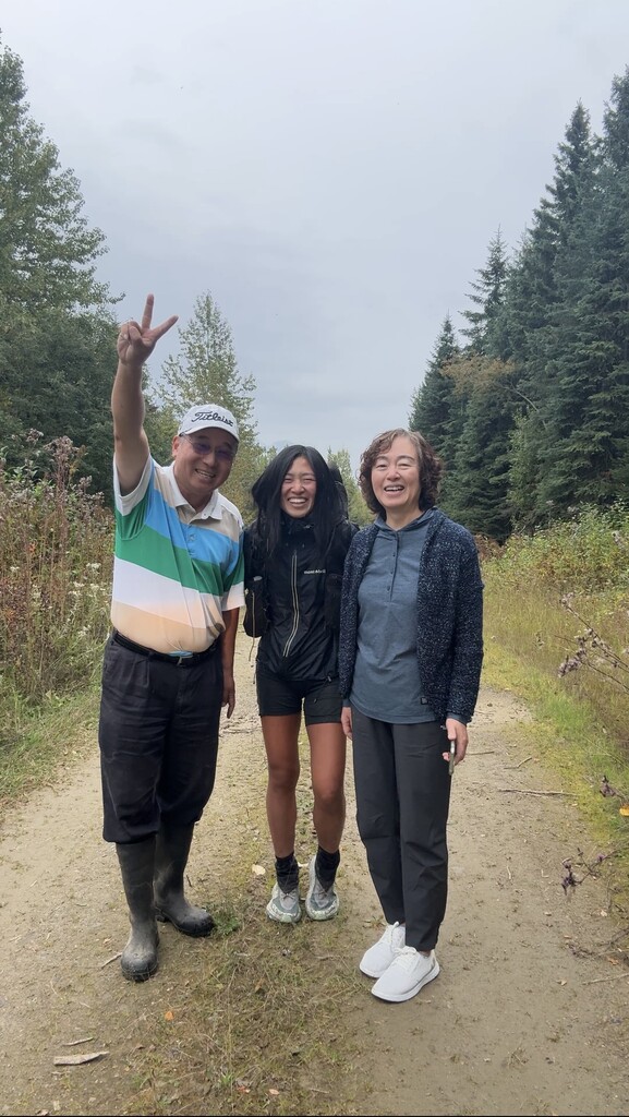
Hiking Partners: I hiked almost all of this alone, apart from two weeks (~280 miles) I spent with my hiking partner Slide through the San Juans range of southern Colorado from Chama (Cumbres Pass) to Monarch Pass. I spent a few hours hiking with two CDT hikers on my sixth day (Pickles & Freight Train) in early New Mexico, hiked a mile with my friends Pickle (different Pickle) and Pin Cushion north of Helena on the CDT (MacDonald Pass), hiked about seven miles with my friend Lucy Barnard into the town of Coleman on the GDT (section A), and did about 2 miles on the ridgeline and descent from the Perseverance High Route on the GDT (section G) with two hikers Sagi and George whom I'd met at the summit. Due to the timing of both hikes and the generally limited numbers on these trails, I passed the two major CDT NOBO bubbles by Pie Town and then in Chama and was probably a week or so behind the primary GDT hiking season. In total I spent 28 days seeing absolutely zero people, 41 days seeing zero people on trail (but seeing people in town), and 22 days seeing only one other person.
Conditions / Gear: I encountered continuous or extended patches of snow from approximately 30 miles south of the Colorado border till approximately 5 miles north of Encampment, as well as consistently at the passes in the Wind River range on the high route. I carried microspikes, crampons, and an ice axe from Chama, NM; added snowshoes at Pagosa Springs, CO (but could have used them before!); sent back the crampons and ice axe in Breckenridge, CO (if I'd kept them, I likely would have taken the Argentine Spine and Pfiffner Traverse route on the main CDT); sent back the snowshoes at Steamboat Springs, CO; and sent back the microspikes from Encampment, WY. In total, I walked in snow or extended patches of snow for 39 days. I did not carry spikes, crampons, or an ice axe for the Wind River High Route but would have found spikes and an ice axe to be helpful reassurance. I did not carry a bear can but I did carry an Ursack and bear spray from Lander, WY through the end of the GDT.
Pace: On the CDT, I averaged 24.5 miles per day including town stops and zeroes (which breaks down to 28.3 mpd in New Mexico, 18.4 mpd in Colorado, 23.8 mpd in Wyoming, 29 mpd in Idaho, 29.2 mpd in Montana). On the GDT, I averaged 19.5 miles per day including town stops and zeroes. I relied heavily on nearos ranging from 4 - 36 miles in length in order to have enough time in town to get all my chores done, including documenting my hike which took significant effort / time in town and on trail. In general, my daily goal for mileage was high 20s to low 30s in New Mexico as a warm up, 20s in the snow in Colorado and mid to high 30s on snow-free sections, mid 30s in Wyoming and 15 - low 20s on the high routes, mid 30s in Idaho, and mid to high 30s in Montana. Ideally I would have liked to do higher mileage (e.g., low 40s) in Wyoming through the flatter sections such as the Basin and Yellowstone, but I was nursing anterior tibialis tendonitis due to the stress of the extended snowshoe usage in Colorado through the Basin and then was dealing with an allergic reaction to mosquito bites in Yellowstone / early Idaho. I did have one 42 mile day through Yellowstone, which was my longest day on trail. On the GDT, I was aiming for 20 - 29 miles per day.
Timing I entered Colorado on May 15 and exited on June 19. For the GDT, I wanted to enter Canada by early to mid August and booked several permit itineraries ranging from 24 - 36 days that all started on August 11 (I entered Canada one day later than planned due to Glacier permit availability). My goal was to be finished with both trails by September 20 to exit before snowfall became more likely (though you can get snowfall in these parts at any point in the summer season). This ended up working out well because in the week following my exit, sections F and G of the GDT received two snowstorms. On the CDT, my time breaks down into 25 days in New Mexico, 35 days in Colorado, 26 days in Wyoming, 11 days in Idaho, and 17 days in Montana.
Resupplies: I resupplied at the following places:
CDT
- Lordsburg, NM - shipped
- Silver City, NM
- Doc Campbell's, NM - shipped
- Pie Town, NM - shipped
- Grants, NM
- Cuba, NM
- Chama, NM - shipped
- Pagosa Springs, CO
- Lake City, CO - shipped
- Monarch Pass, CO - shipped
- Twin Lakes, CO - shipped
- Silverthorne / Dillon / Frisco / Breckenridge, CO
- Grand Lake, CO
- Steamboat Springs, CO - shipped
- Encampment, WY - shipped
- Rawlins, WY
- Lander, WY
- Green River Lakes TH, WY - I was met here with food
- Jackson, WY
- Flagg Ranch, WY - I was met here with food
- Old Faithful Village, WY - shipped
- Lima, MT
- Leadore, ID - shipped
- Wisdom, ID
- Anaconda, MT
- Helena, MT
- Benchmark Ranch, MT - shipped
- East Glacier, MT - shipped
GDT:
- Waterton Lakes
- Coleman / Blairmore
- Boulton Creek - I had food brought here
- Banff / Canmore - I had food brought here
- Field / Golden - I was met here with food
- The Crossing Resort - I was met here with food
- Jasper
- Blueberry Lake Trailhead - I had food brought here
---
Conclusion:
I submitted this route after being unable to find much detail online about other attempts to link up these two trails. If you are reading this hoping to do this same link-up, I highly recommend it. It's an incredible opportunity to walk along the spine of North America. You will start in the barren high desert of New Mexico and end in the high peaks of the Canadian Rockies among glaciated peaks. It's beautiful and very isolated and remote. It will challenge you mentally and physically in its tedium and in the fast-changing conditions and tough terrain, and you will cry with wonder at the open expanses and rugged beauty -- and you will feel honored to be walking along the source of the water that serves so many millions of people and creatures and ecosystems across so many landscapes.
I will be sharing more detailed trip reports and planning resources / reviews on my blog at The Trek and Substack. You can also watch this hike day-by-day on Instagram or TikTok at @whereisjessi.ca. I hope this helps someone else follow in my tracks :)
This was one of the most incredible adventures I've ever been on. I'm very grateful I was able to make the space and time in my life to go after this, and very grateful to all the people who helped me both on and off the trail, and both on and offline. Thank you!
-- jess / stitches
Comments
Incredible. I learned about this route yesterday and begin planning today. Thanks so much for your epic chronicling of this effort. And big kudos for completing the route!