yesterday I saw a weather window to see what I could do at the moment on a route I’ve spent a lot of time on the past couple years, the Lion’s Head Winter Route on Agiocochook (Mt. Washington). After a season of ice climbing and walking at a variety of speeds with a pack on, running/jogging still feels weird. I feel like I haven’t fully dove back into trail running since my kneecap break this past fall, but here we are!! Gotta hop back in the saddle at some point…
My intention was to try to move efficiently on the ascent and to hike the descent. With an Alaska trip and a season of guiding in the Tetons coming up, there’s no way I’d forgive myself if I went down going bananas on the downhill.
I didn’t look at my watch til the alpine garden and when I did, realized that I was near or maybe slightly ahead of Abby's time, so I kept plugging along. Stopped to add a layer at Split Rock, took my microspikes off on the currently rocky (but not for much longer!) summit cone and immediately regretted it upon arrival to the summit, which was a complete sheet of ice 😂😅.
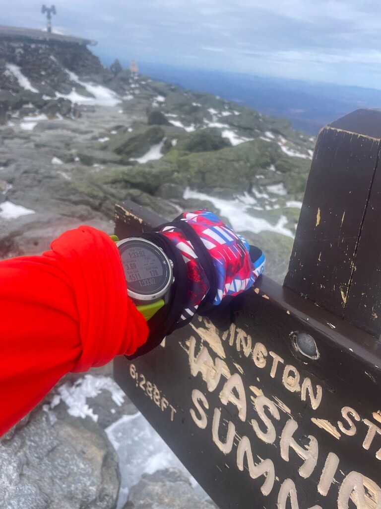
Booped the summit sign in 1:33 (pending verification, new LHWR fkt), maybe a little under because it took me a sec to get my phone out to take a photo of my watch for proof aaand my headphones proceeded to break in that moment. Thrilled to lower the time for another woman to go snag it! My time from Pinkham to the summit via the full Tuckerman Ravine Trail is 1:24, so for a more technical route to not be too far behind I was surprisingly pleased :) I didn’t see another soul above the Winter Route turnoff, so the solitude up there was damn near spiritual.
A few thoughts: The LHWR is considered a 4th class mountaineering route. Being familiar with its current conditions, extremely confident in my knowledge of the route and the forecast for the day, I was comfortable wearing Goretex trail runners and microspikes. If I had been going any slower, that would’ve been too minimal, and margins for error there get small. I carried an emergency bivy kit, the lightest @blueiceclimbing ice axe I have, a midlayer, a puffy jacket, 3 pairs of gloves, a variety of snacks, a balaclava and about a liter of water distributed between 2 soft flasks. As a guide and mountain rescue personnel, I tend to now think of the “what if I were to go down out there?” question, and I’d suggest folks going to try this route also think through and prepare for what they’d do if something were to go awry. I also *highly* encourage not forgoing an ice axe on this route in the name of minimalism. The potential for a long sliding fall on the snowfield (where you could potentially LSF your way all the way down into Tucks) or down the Wilcox Step is real. I found myself not using the ice axe on the way up due to my familiarity with the route, but would’ve been quite gripped without it on the way down, was caning with it the entire bulletproof snowfield and swung it a few times while downclimbing on the Wilcox Step.