
The 35ers have captivated me for years. I’ve done a self-supported effort with a car but I really wanted to link them all on foot. I tried this last year in October. It did not go well. I had really bad stomach issues and was going so slow I was pretty sure I wouldn’t be done when I needed to.
This spring was going to be different. I did more route and nutrition prep, tinkered with more gear, and arranged a car shuttle. A few days ahead of time however the forecast started calling for heavy rains and my car shuttle backed out. I knew I probably wouldn’t have another window until fall, so I added more rain gear, reversed my planned direction, and stashed a bike in the woods at the end. With the forecast I also decided to bring a tent, unlike last year when I relied only on a bivy. By the time I drove to the Catskills and took care of the bike drop, it was already after 9:00am.
I started with Bearpen and Vly, where it actually snowed a little. There are a number of ways to link all of the peaks together. I’m not sure starting/ending with Bearpen and Vly is the most efficient (I’m not aware of anyone else who has), but it’s close. I’ve spent hours staring at maps trying different routes. Some people who have done this route before have used shortcuts through private property (sometimes with permission) but I wanted to stick to public land to the best of my ability. This definitely adds some mileage but in many cases avoids some tricky bushwhack sections. After Bearpen and Vly I proceeded in a largely counterclockwise direction, roadwalking to Balsam Lake, then the Big Indian Range, the Catskill 9, Panther, Halcott, the Other 9 plus Rusk, KHP and finally the Windham Blackhead Range.
It rained a little on day 1, but the heavy rain came on day 2. This is also when my phone got wet and died (I blame the cheap ziplock bag lol). This presented some issues. I had told more people than usual that I would be in the mountains and I didn’t want anyone to worry or call SAR. I only had a few numbers saved on my inReach, but I was able to connect to everyone I needed to (as well as arrange a car shuttle for the end!) I had also downloaded some podcasts, books, and music I had planned on using as motivation later on. And besides losing my camera, the pictures I had taken the first two days were gone. My feet were also wet for most of days 2 and 3. This led to more blisters than I had ever experienced. At least there was plenty of water to filter. Also starting on day 2 I began experiencing stomach issues again, not as bad as last year, but I was only able to eat roughly 9000 of the 14,500 calories that I started with.
I was hoping to get through the Devil’s Path before darkness on the 3rd day. I made it through Hunter, but I got to tackle the more challenging eastern half in the dark. I would not recommend this. The last day seemed to drag on forever. Windham has several false summits. I made it up there in time for a beautiful sunset, then “ran” down the mountain, trying to make it down before 3 ½ days elapsed. My friends were there with cowbells waiting to great me. My car wouldn’t start, but they gave me a ride home.
For sleeping I brought a 14oz tent, a small pad, and a small puffy blanket. I carried all of my gear in a 15L vest, with the tent attached to the chest straps in front. I slept the first night at the base of Fir for roughly 3 hours, then a very indulgent 7 hours after Panther when I was trying to decide if I should drop (and when I didn’t have a working alarm anymore), and another 2 hours after Plateau when I was again feeling determined to finish.
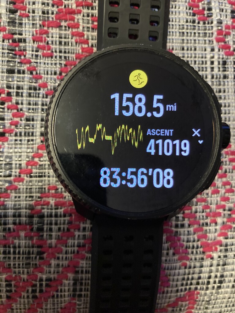
My watch failed me again. The activity is still “on” the watch, you can see starting time, elapsed time, elevation gain, etc. but according to three people I’ve talked to at Suunto there doesn’t seem to be a way to load the activity to their app. The wireless sync gets to “99%” then crashes. I’ve tried this a couple dozen times. One of the downsides I guess of relying solely on Bluetooth for data transfer. Apparently this watch is not capable of hardwiring into a computer. Fortunately I tracked the entire thing with my inReach as a backup (which I started a little before and ended a little after). The elapsed time on my inReach is slightly more than on my Suunto, so I’ve included a picture of the activity screen from the watch. The final stats were 158.5 miles with 41,019' of gain.
I believe the previous best time without support was 4 days, 13 hours, 5 minutes by Cory Delavalle and Jan Wellford in May 2011. I would love to know what route they took. I know of at least 3 others who have attempted this, but I’m not aware of any faster unsupported efforts.
Comments
Hi Matthew, I’m interested in doing this FKT in the spring 2027. I’m sure I’m not even going to be close to your time. I can’t find a female FKT on this one. I have a few questions.
your watch is 158 miles but your garmin says 132 that a big difference. Which one is correct?
I assume you only used public land and the route that from the garmin I reach is the correct route
just like you have spend hrs on routes. Which route planning program/app did you use
thank you Antonia
That’s awesome! Yeah, I haven’t found any female times either. 158 is very close, my InReach was set to 10 min intervals so it underestimates mileage. Yes, I only used public land. There are definitely some ways to cut mileage, but I think this is close to the most efficient route. I mostly used Gaia for route planning, but also a lot of in person scouting.
Thank you!