Athletes
Route variation
Standard route
Multi-sport
No
Gender category
Male
Style
Unsupported
Start date
Finish date
Total time
5h
31m
33s
Verification
GPS track(s)
Morning_Run_101.gpx4.86 MB
Report
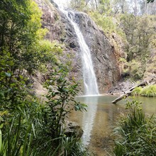
I started near Boundary Fall Picnic area at 7am in anti clockwise direction. I walked the first km and reached Gwydir Hwy after 3km. The next 15km section until Mulligans campground was mostly flat with small hills. Getting out of Mulligans towards Gwydir Hwy is the longest climb of the trail followed with a long downhill, both on wide trail/road for about 9.5km. Ater that I ran a bit slower as it was getting hotter around 11am. The last part from Coombadjha camping grounds back to Boudary Falls is about 17.5km with a lot of hills. It was a beautiful trail with diffrend landscapes every few km's and creeks to refill my water bottles. Thank you to the NSW National Parks to hire out PLB's for free!


