Location
United Kingdom
Distance
81 km
Vertical Gain
1,878 m
Description
GPS Track
activity_5040101920.gpx5.34 MB
FKTs
Male
| Dan Evans | 9h 26m 14s | ||||
| Allen Davis | 12h 44m 18s |


Comments
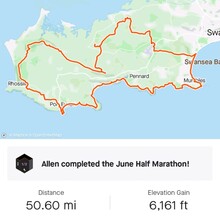
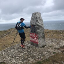
The route is run in a clockwise direction starting at the Gower Society Monument on top of Port Eynon Point, Gower Peninsula, South Wales, UK. The trig point sequence is as follows:
1. Port Eynon (108m) SS453861
2. Rhossili Down (193m) SS419888
3. Llanmadoc Hill (186m) SS430924
4. Ryers Down (115m) SS457921
5. Reynoldston (154m) SS486902
6. Cefn Bryn (186m) SS518889
7. Cil Ifor Top (118m) SS506923
8. Penclawdd (103m) SS544952
9. Fairwood (104m) SS570923
10. Clyn Golf Course (131m) SS598909
11. Black Pill (11m) SS621908
12. Mumbles Hill (77m) SS624875
13. High Penard (97m) SS570866 - Trig point inaccessible from coast path as on private land you can see it from the coast path at Pwlldu Head.
14. Oxwhich (86m) SS505856 - Via the church and up the steps.
This looks like a brilliant route!