Introduction
The RATT Ultra would be a notable route based solely on the fact that it covers the entire length of Cape Cod's beaches; what makes it particularly noteworthy is that it is only possible to run it if timed to the tides, which otherwise make several sections impassible. The tides also determine the start and stop points, which rise and fall twice a day. The course shaped by the gravitational pull of the moon on the tide represents a unique challenge to even the most experienced runner. It requires a different type of planning, preparation, and approach than other runs.
The available infrastructure makes this destination an ideal challenge for runners looking for solo and unsupported runs and or bringing crew along with them, who can have access to comfortable beds, fantastic food, and views while supporting their favorite runner.
This route connects the North Atlantic Ocean with Cape Cod Bay, and since both coasts are East and West facing, the runner is also rewarded with watching an ocean sunrise and sunset on the same day. This route is a true hidden gem that can be used as a weekend training spot for accomplished NYC and Boston ultra-runners, as well as being the perfect destination for anyone who dreams of running an ultra solo and unsupported.
Article about the route & Alex's initial run: https://www.capecodtimes.com
Run Description
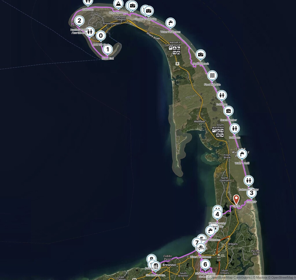
The run has eight gates and is divided into four distinct sections.
1. Capecod National Seashore Park (Gates 0-3)
Mile 0 The run starts in Provincetown (Gate 0) at Pilgrim’s First Landing Park. Parking is difficult to find during the high season. I arranged with a taxi service to drop me at this point. It is only possible to cross here with the mid-low tide.
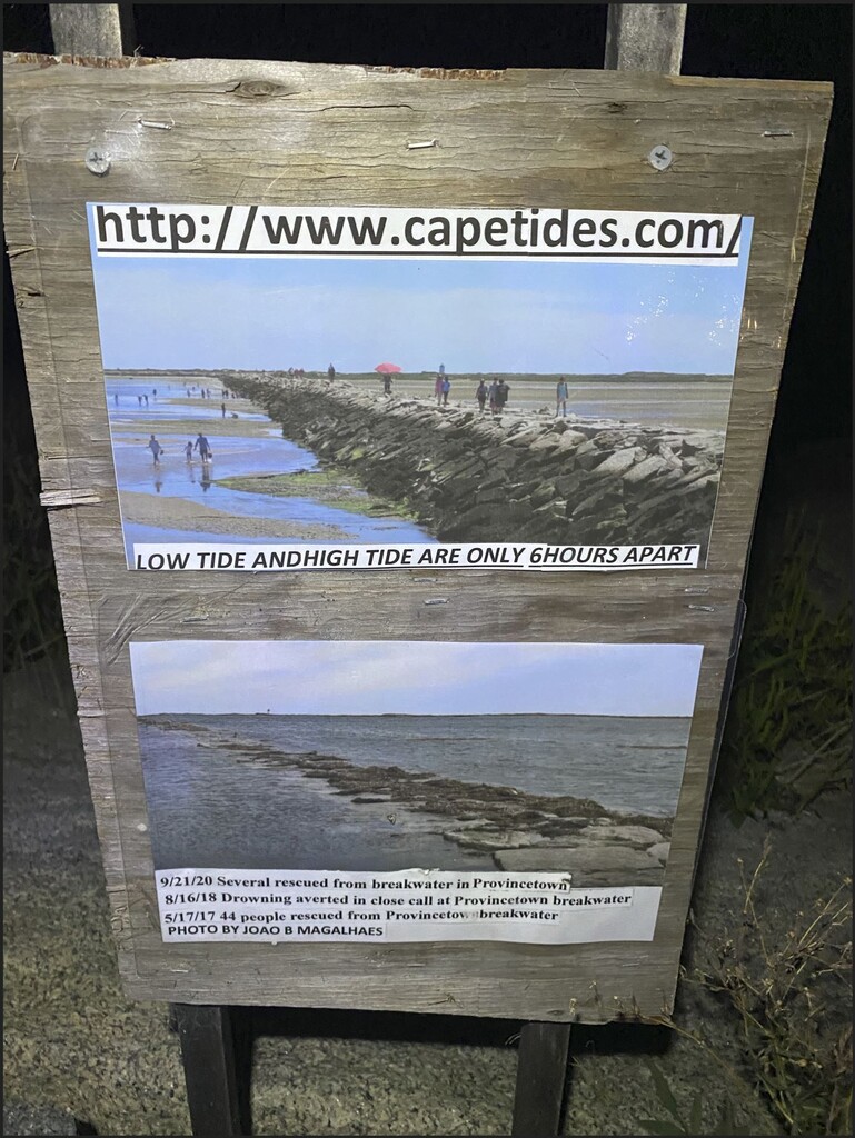
From there, I jumped on to Provincetown Breakwater (Causeway) and walked-ran over the rocks for about 1 mile to the Wood End sand bar until (Gate 1) and turned north toward Wood End Lighthouse. Follow the coast for 2.3 miles to find the first bathroom and water stop at Herring Cove Beach facilities. This is the first section that gets under water 90 minutes before high tide, as noted in the warning sign at the breakwater entrance.
Be aware that there are several sources for Tide Charts, but be careful that some of these sites are there to collect advertising money and their information can be quite off. I found that NOAA tides and current predictions are the most accurate.
Mile 5.3 Hatches Harbor (Gate 2) is the second challenge. At high tide, this section will get swamped with head-high water and possible undertows. I timed the run to pass this section 1’ 46” after low tide and I only needed to go over a small 5-10 yard section with knee-deep water, from there an additional mile running towards Race Point Lighthouse. The lighthouse marks the point of departure of Cape Cod Bay to the outer side of the cape facing the North Atlantic Ocean.
On mile 10, I took a detour to get a glance of the Dunes of the Provincelands for about 3 miles, then returned to the seashore on mile 13. I ran 21 miles straight through the seashore, battling soft sand as the high tide started to corner me against the park’s cliffs. Soft sand, sun, and wind factors had an incredible impact on speed and the ability to keep on top of water and salt intake. Along this section, I witnessed hundreds of seals, one shark, several dozen types of birds, beautiful wind-sculpted sand patterns, and a nudist beach. There are five water, shower, and bathroom stops, which are part of the National Park Service infrastructure.
2. Nauset Trail traverse to First Encounter Beach (Gates 3-4),
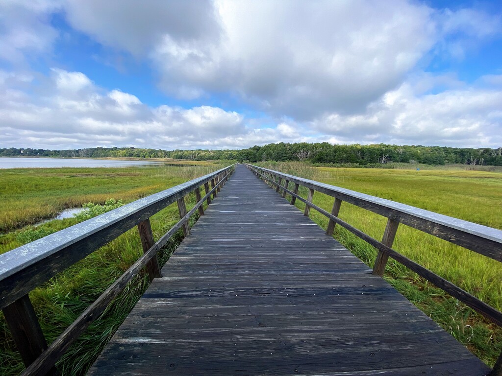
Mile 34 marks the National Seashore exit (Gate 3). The run goes westbound towards Cape Cod Bay through the Nauset Trail. The trail is 3 miles long and winds along the edge of the Nauset Marsh through a recovering forest that ends in the Salt Pond Visitor Center. I stopped in this spot early in the morning and left a food cache hidden behind the bathrooms. On my way back after 12 hours running, I was happy to see that my food was intact, and the chicken wrap, frozen oranges, and watermelon were still fresh and ready to be devoured. This is an excellent place to refill all water bottles since there is no water for the next 8 miles. There is a small 3 mile run through local roads from the Center to connect with First Encounter Beach (Gate 4).
3. Brewster Salt Flats and (Gates 4-5)
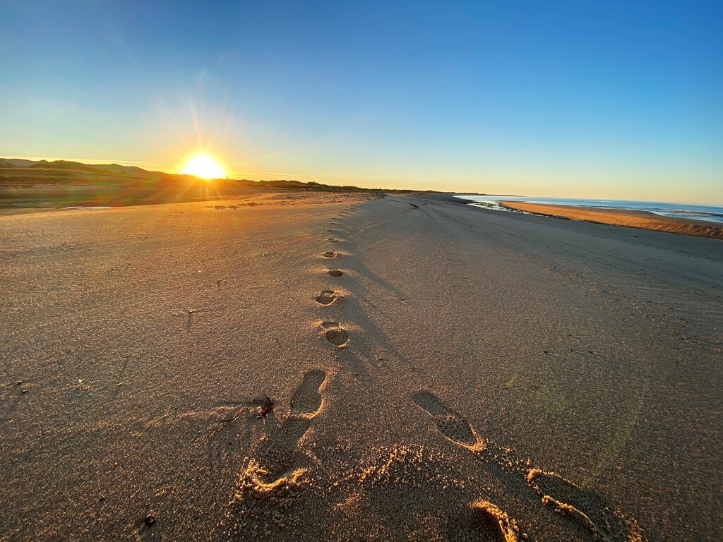
Mile 40, First Encounter Beach, marks the third pass that depends on tides. At high tides, water is deep enough for mid-size fishing boats, and barely any water at low tide. There is no internal trail since the coast is flanked by marshes. At 6 pm, the place welcomed me with a magnificent sunset and 3 miles of hard-packed (and wet) sand. At this time, in some sections, the water may be knee-deep, but for the most part, it is runnable. The exit of this section is a car road named Crosby Landing (Gate 5).
Note: running in Brewster flats during low tide is a safe activity; getting inside the marshes can be dangerous. What appears to be sand bars next to the rivers are often quick sands instead. Vegetation is overgrown, and there are not many people around, so it is possible to get stuck there, without readily available help. There is cell coverage in that section, but dealing with quick sand after long hours of running is no fun. Take my word for it.
4. Nickerson State Park and finish line (Gates 5-8)
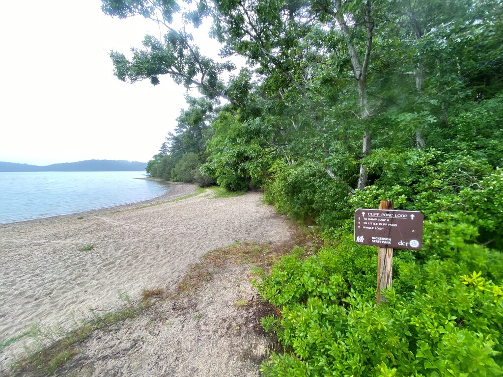
Mile 43 marks the Entrance of Nickerson State Park, a beautiful six-mile loop around three kettle ponds surrounded by woodlands and sandy shores. Trails are very well kept and also extensive. The trail system is very complex. I relied on both my Garmin watch and Gaia GPS app to keep track of the trail since it is very easy to get disoriented and take the wrong turn. Gate 6 marks the outer part of the loop as a reference point. From there, I ran back to Crosby Landing (Gate 7) to tackle the final section of Brewster Flats towards the end of the run; Nickerson Park is the last water fountain.
Mile 52, Crosby Landing (Gate 7) marks the last section of the run. This section of the beach is perfect for running a final sprint towards Paines Creek Landing at mid to low tide. At high tide, most of the section is doable, however, there are many private jetties from coastal homes that need to be sorted out. In some cases, locals may not be happy with the idea of having runners passing by their property boundaries with their ubiquitous private beach signs. Another alternative is to get a little bit wet. This is ok in summer and fall, but spring water can still be in the low 60s to upper 50s.
After a short run through a local street, Mile 57 marks the end of this incredible run. There is an open mall (Lemon Tree Shops) with ample parking and a good food selection. If you are lucky enough to stay a few yards down the road at the Sea Meadow Inn, your crew, a hot shower under the stars, and a warm bed will be waiting for you after a long day of running.
Alex.-

Comments
Super cool route! Would love to try it someday!
Our Sea Meadow Inn is now open to host runners who aim to break the current record. The tentative date for the event is September 24th. First week sept 16 is sold out. For more information, kindly visit https://ultrasignup.com/register.aspx?did=99570.
On Tuesday, September 26th, 2023, I will attempt to break the course record by starting half an hour before the first low tide at 12:01 AM. My Garmin InReach tracker is share.garmin.com/ratt50.
Alex
Done. Waiting for FKT team to validate the new course record