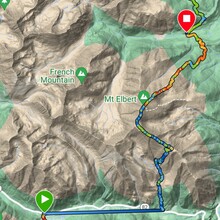
Traversing across a skyline's worth of ridges, and piling up over 30 miles of foot travel, bagging 3 of the 5 tallest peaks in Colorado in under 24 hours, the Cloud City Highline is believed to be a new high altitude link-up in the Colorado Rockies, and it ain't for the faint of heart.
Named after the nickname given to the nearby city of Leadville, this route totals over 14,000ft of total gain on the day with over 10 miles of exposed ridge lines. It begins with an out-and-back of La Plata Peak, Colorado's 5th tallest peak. Next is Mt. Elbert, the tallest peak in the state, via the southern ridge. Descending Elbert on the opposite leaves you right at the Mt. Massive trailhead to tackle your 3rd 14er of the day, Colorado's 2nd tallest. Your day wraps up back at camp on Halfmoon Rd.
***the attached GPX includes one discrepancy. There is a few miles of driving, one stretch, between two trailheads, and those miles are included in the total milage of the activity. The total distance BY FOOT is 30.93 miles.
***I am an amateur in this space. The planning, training and logistical figuring of this challenge began over 2 years ago and was largely fueled by the diagnosis of a chronic health condition. To my knowledge, this is a bespoke route, and new challenge. Any claims proven to be false will be changed and apologies issued accordingly!
Garmin course can be found here.
Editor's note: there will be two variations of this route, for the consideration of athlete safety. The "transition by foot" variation requires the athlete to shuttle themselves from the La Plata trailhead to the Elbert trailhead by foot (about 4mi on Cottonwood Pass). The "transition by car" variation allows the athlete to drive this stretch, while taking particular care to adhere to speed limits and rules of the road.


