This 7.4 mile run of 505 ft. elevation gain starts in Historic Ellicott City, MD and takes you on foot through the heart of Catonsville, aka "Music City, Maryland." It transits a series of old rail line converted to hiking and biking trails into Ellicott City and through Catonsville.
You may have heard of the catastrophic flooding that pummeled Old Ellicott City on May 27, 2018, less than two years after another torrential rainfall flooded the same area on July 30, 2016. The Main Street area continues to recover to this day, but through it all has remained vibrant with a strong community that represents small town America at its best.
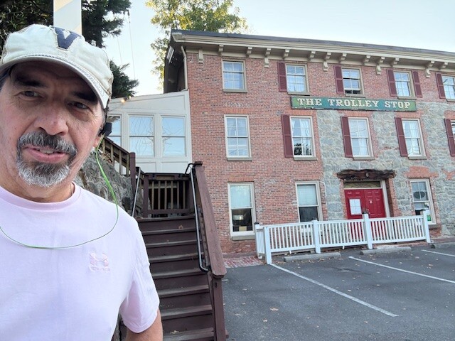
The run starts at the bottom of the steps that let out in the parking lot of the Trolley Stop Restaurant. The Trolley Stop restaurant was named for the #9 trolley which made its final stop at this historic 1833 building. That building served as a tavern and inn on the Ellicott City to Catonsville line. The trolley stopped outside the restaurant's second-floor dining room from its service start until its last run on June 18, 1955.
The steps in the restaurant parking lot lead to the bottom of the #9 Trail. The historic Ellicott City/Catonsville Trolley Line #9 Trail is a 1.25-mile boardwalk and paved trail. (In 1991, Aaron Tomarchio of Boy Scout Troop 456, organized the effort to clear and pave the #9 Trolley Line for a bike/hike trail as part of his successful Eagle Scout project. It has since provided scenic and shady enjoyment and exercise for hundreds of thousands walkers, joggers, and bikers of all ages.)
The top of the trail will lead you out onto Edmondson Ave, where you will continue uphill past Catonsville Middle School and across North Rolling Road where you will start a decent through a short section of shops and restaurants.
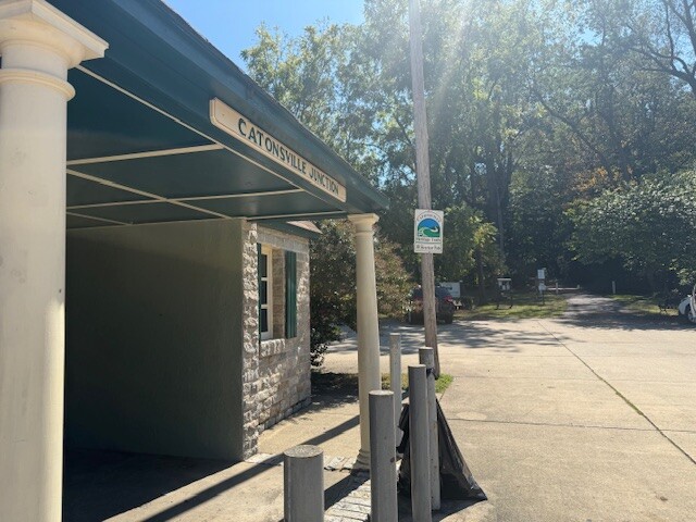
At around the 1600 block of Edmondson Ave, just past Scittino's Italian Deli and before reaching 7-eleven, you will cross Dutton Ave. and angle to the right towards the still standing Catonsville Junction built at this intersection. The Junction was a key trolley transfer point for the #8, #9 and #14 lines. The last streetcar in Baltimore ran on this rail in the early morning hours of November 3, 1963. (It's a little over a mile from the #9 Trolley Trailhead to the Junction.)
Just past the junction is the bottom end of the historic #8 Streetcar Path. This paved trail through woods behind houses is about .4 miles, but can feel longer as it is all uphill.
That trail ends at Frederick Road. Head left down the sidewalk past Hilcrest Elementary School and South Rolling Road and into the downtown Catonsville. Cross the street at your earliest (safe) convenience after you pass the Catonsville Library on your left. You may not a memorial tribute to the Catonsville 9, famous Vietnam War protesters that burned the draft files of many young Catonsville men back in the day.
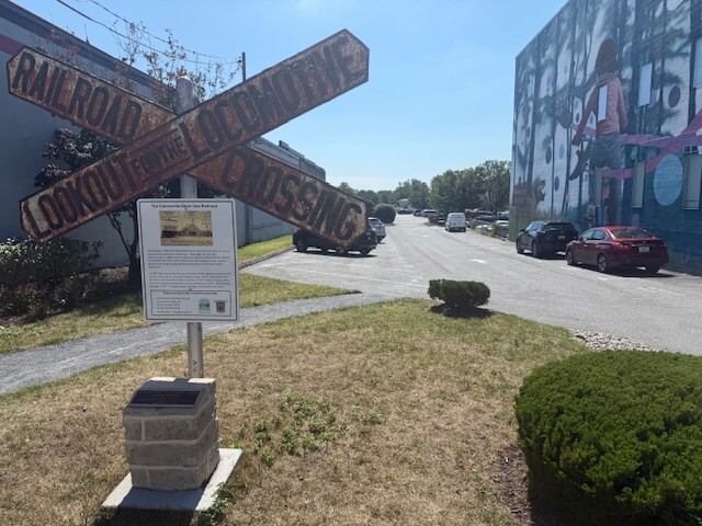
Around the 800 block of Frederick Road, you will cross Mellor Ave. (This is just under a mile from the #8 Streetcar Path.) The Catonsville Fire Station will be on the left as you cross Mellor. Just past the corner building on your right, and directly across the street from the Fire Station, turn right and you will see the big old Railroad Crossing Sign marking the trail. A big mural will be on the side of the building to your right.
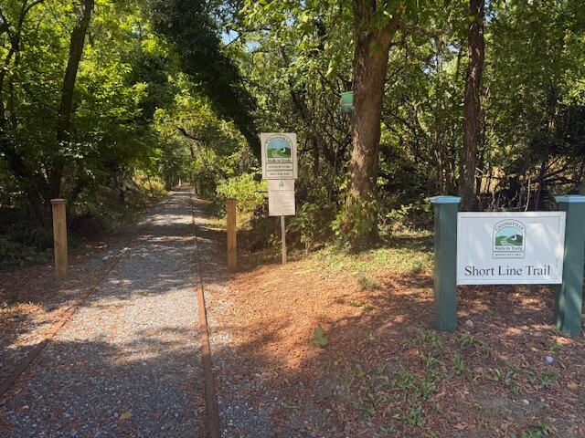
You are now on the Short Line Trail. It begins across the street from the Catonsville Fire House and meanders through a dozen Catonsville neighborhoods, Spring Grove State Hospital Center and the neighborhoods of Paradise, past Charlestown Retirement Community, and into the Kensington neighborhood. (Once on the Short Line Trail you have about 3.45 miles to the end of the run.)
Run through that parking lot with shops to your right and the music legends to your left. As you get to the end of the lot, cross the street and angle a little to your left. The Short Line Connection Trail begins with a boardwalk that runs past the pickleball courts and above the Catonsville Elementary School grounds. This connects to a gravel path that re-enters the woods for a short stretch before hitting some stairs and a ramp that brings you up to Bloomsbury Ave. Cross the street and head down Asylem Lane.
You'll be heading down towards Spring Grove Hospital Center, the second oldest continuously operating psychiatric hospital in the United States, founded in 1797. It provides mental health services to patients from across the state, including forensic evaluations and treatment for the seriously mentally ill. The 180-acre campus features numerous buildings, including a community garden and a historical research facility. Don't worry though, you won't be entering the hospital grounds!
At the bottom of the hill, you will turn left and pass the sign for Short Line Trail, Spring Grove Section. This gravel path runs between the hospital grounds and the Cinnamon Tree Court neighborhood. You will pass the old power plant for the Hospital on your right as well as a number of other structures. You may also see some feral cats, deer, or fox, depending on the time of day as you run through those woods. Follow the trail to the small wooden bridge and take the ramp to the right down the railed section. The rails are well maintained with gravel so your footing is fine.
That trail lets out on Wade Ave. Turn left and head up the street to where it ends at Frederick Avenue. Turn right and head over the bridge that crosses over the Baltimore Beltway. Be careful crossing the on ramp to the Beltway before you get on the bridge.
About 100 feet past the off ramp from the Beltway on the other side of the bridge, you will bear right down a little path just before you get to the houses. This path will weave onto an alleyway behind some row homes. Follow that to the end and go left up to the street. Turn right on Blakeney Road and then a quick left on Altamont. In about 250 feet, you will hit the first cross street. Turn right on Shady Nook Ave and follow that down and around to the right until you see a train mural to your right and a sign on your left for Catonsville Heritage Trails Short Line R.R. Go left onto the gravel trail and keep following that straight through the woods.
You will cross a small street and at one point may notice Western Tech High School through the woods to your right. Be careful crossing Maiden Choice, which is a busier road further down the trail. There is a crosswalk there for the trail, but you should still look both ways twice.
You will pass the Baltimore National Cemetery on your left, a little past that road. This was one of seven national cemeteries created between the World Wars, 1934- 1939. It was the Army's first major expansion since the Civil War, directed at serving a growing veteran population and rapidly depleting burial space at existing national cemeteries. It definitely has a military feel, but doesn't look that old. Plenty of residents there.
The trail may look like it is coming to an end a little further on, but run past the bench at the end and you will see that it continues. Follow this dirt trail around, with the fence to your right. On the other side of that fence is the property of Charlestown Retirement Community, a senior living facility. This section of the trail is not yet developed but it is runnable. It is a little narrow in spots and does have a lot of roots, so watch your step.
That section finally opens up to the newest section of the trail project, the Beechfield Track Section. This is a pretty straight, about 350-yard section of tightly packed rock that is great to finish out on a sprint. The trail currently ends at Beechfield Avenue, 7.4 miles from the Trolley Stop steps where you started.
If you have two, I recommend leaving a car near S. Beechfield Ave. and S. College Rd. (not far from Wilkens Ave just inside the Beltway) and then driving to Ellicott City to the free public lot just past the Trolley Stop to do the run. Then, when you are done the run, drive back and have a nice lunch or grab a beer in Historic Ellicott City and check out the scene there. If you are here in the summer, be sure to check out Frederick Road Fridays Live Outdoor music stage or the Lurman Woodland Theater concert venue on Saturdays and Sundays: https://lurman.org. :)
Note- The run is a little easier from the top (i.e. Beechfield) down, but it doesn't hit 500 ft. elevation gain going that direction.
Special shout out to the committed individuals that spearheaded the Catonsville Rails To Trails project and work tirelessly to keep the trails in excellent shape.
The mission of the Catonsville Rails to Trails, Inc. (CRTT) is to unite individuals, businesses and organizations in the community around the common theme of promoting healthy living through hiking/biking trail enhancements in the greater Catonsville area.
For more on Catonsville Rails To Trails or https://crtt.org/catonsville-mural-virtual-tour/


Comments
How is this an FKT? It's just someone's route. The idea is that the route itself is supposed to be historic. Not that you run through an area that has history -- every area has history. This route doesn't even follow a historic rail line. It intersects part of a very minor local rail line