Starting at the northernmost point of Sicily, this route primarily follows the island's entire east coast, passing some of the most breathtaking historic cities, mountain crossings, majestic cliffsides, both white and black sandy beaches, and prominent structures originally erected by the ancient Greeks thousands of years ago. And then there's Mt. Etna, Europe's most active volcano, visible for much of the route. You can literally watch as smoke billows from the top all throughout your attempt.
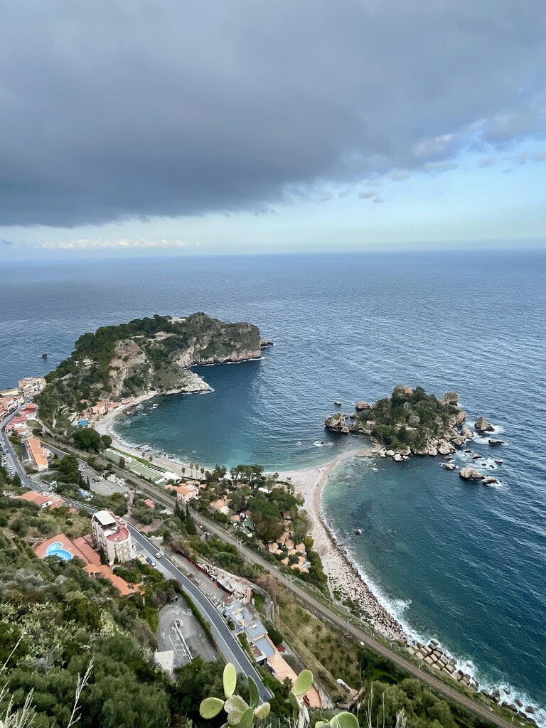
This seaside route is as gorgeous as it is steeped in history. It starts just north of the famous port town of Messina, one of the main connection points to the rest of Italy. It then follows the coast through everything from sleepy fishing villages to monumental municipalities of quintessential Sicilian life and culture. This includes the cliff-top city of Taormina and its incredible views of the coast, its many castles and churches, the volcano, and Teatro Antico di Taormina (ancient Greek theatre). Another highlight is the regional capital and ancient port city of Catania with its richly adorned cathedrals, the famous Fontana dell'Elefante (Fountain of the Elephant), and its spacious town square Piazza del Duomo. Next, the route puts the stunning panoramic views of Mt. Etna and its hilly coastline behind you as you head for Syracuse and its quaint old town island Isola di Ortigia. This region is famous for many things, but none stand out as much as its ancient Roman and Greek architecture, including highlights such as the Neapolis Archaeological Park, the Roman Amphitheatre, the Ear of Dionysius, and, of course, the Temple of Apollo, which dates back to the 6th century B.C. Finally, the route winds its way down through picturesque seaside villages until it reaches the sandy beaches of its southernmost point. Just like notable destinations such as Rio and Lisbon, this historic location is marked by a statue of Christ the Redeemer (Statua del Cristo Redentore), although this rendition is a bit smaller. The statue also includes a plaque declaring this exact spot as the southernmost point of both Sicily AND Italy. It also just so happens to be the exact spot where the Ionian Sea meets the Mediterranean, meaning this route passes by three separate seas in total. With thousands of years of rich history, there are simply too many locations and landmarks to mention. This coastline has been visited, inhabited, attacked, and defended by everyone including, the ancient Phoenicians, the Greeks, the Romans during their height, Germanic tribes, Muslim warriors from North Africa, and even Vikings. In more recent history, Sicily played a pivotal role during WWII, and the route even passes by old military dugouts and bunkers facing out at sea. Not to mention the route's endpoint, which lies a few short kilometers from the Monument of Operation Husky, also known as the landing spot for Allied Troops before their eventual takeover of the island.
This is a linear, Point to Point route (Open Course), where the goal is to cross the entire length of Sicily as fast as possible. The northernmost point of Sicily lies just past the northeastern corner of the island. The precise location can be seen on the map, or by going just a few meters east of Sparta Beach. This is a Point to Point route, meaning you can take the shortest route possible. That leaves the door open to some revisions of the course. The cliffside road sections were very tight without much room for safe running.
The first half of the route starts near Messina and ends in Catania. This is where the majority of the elevation gain and descent can be found. After the last "large" climb into Acireale (just before Catania), the route becomes very flat, even including large sections where you can choose to run directly on the beach. One thing you definitely need to look out for, however, is the river crossings. There are multiple locations where rivers and estuaries meet the beach, and in some places, create impassable sections. However, it's important to remember that these impassable sections are subject to change, often depending on the time of year, the amount of rainfall, if the regional authorities decide to open certain floodgates, etc.
And the last section of the route is perhaps the best. Starting in the beach town of Lido di Noto, the route leaves the road and follows a beautiful, well-maintained dirt and sand path, even passing through the gorgeous and relatively secluded nature reserve of Riserva naturale orientata Oasi Faunistica di Vendicari. It then rejoins the road in San Lorenzo and continues along the seaside villages all the way to the Statua del Cristo Redentore statue and its "Southernmost Point of Sicily" plaque.