About the Faroe Islands:
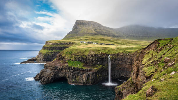
The Faroe Islands is a self-governing archipelago, part of the Kingdom of Denmark. It comprises 18 rocky, volcanic islands between Iceland and Norway in the North Atlantic Ocean, connected by road tunnels, ferries, causeways and bridges. Hikers and bird-watchers are drawn to the islands’ mountains, valleys and grassy heathland, and steep coastal cliffs that harbor thousands of seabirds.
No one has ever run across the Faroe Islands as far as the FKT site is concerned or the internet as far as I can see per my research. As a matter fact there is no FKT at all on the Faroe Islands as of now. The plan is to do this Route fully supported as a father and son (me Thomas Reiss age 57 and my son Luke Reiss age 20) duo with the rest of the family (mother and other son) crewing. The Faroe Islands are one of the most beautiful landscapes on the planet and deserve to be having a run across them. The plan is to attempt this FKT on June 20,21,22 or 23 all weather dependent.
There are several tunnels we need to take a ride to get through them (Running or cycling through these tunnels is both hazardous and prohibited). We will keep our GPS watches running but most likely will loose signal but will have an overall time. We will also track the time spent driving versus running to have a run time and distance and a total time including the driving portion. All assuming we will loose Satellite connection on our GPS watches in the tunnels. Please advice if you have a better idea as far as tracking the effort. Thanks for your advice.
The Route:
The route will begin in the town of Sandavágur.
https://en.wikipedia.org/wiki/Sandav%C3%A1gur
The starting point is specifically at the steps of the historic and distinctive red-roofed Church that was built in 1917, which should be easily identifiable.
From the church, the route will head out of town and onto Faroe Island Route 11. The initial direction of travel will be northbound, moving towards the main part of the island. The route continues on Route 11 turning eastbound. You will then reach the first of several tunnels (Vagartunnelen) located along the course. Here you will have to get a ride in a car since all designated auto tunnels are long and you can not run through them (there are several on this route). Running or cycling through these tunnels is both hazardous and prohibited.
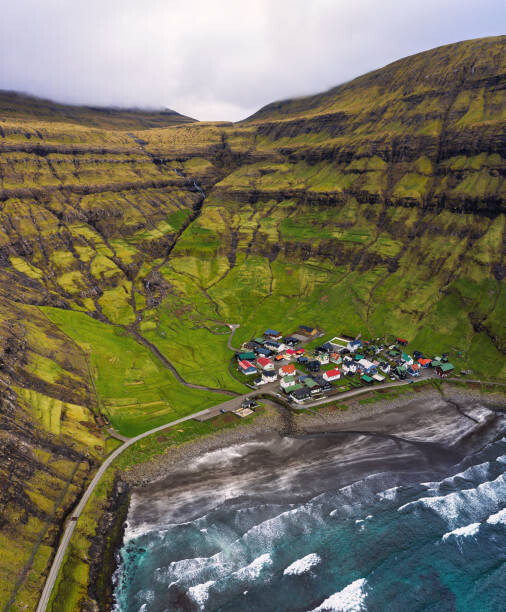
A little while after exiting the initial tunnel, the route arrives at a traffic circle. At this junction, you will need to transition onto Route 40, which leads towards the town of Oyrareingir. Route 40 briefly turns into the 11 before connecting to Route 10 (northbound) taking you towards the town of Kollafjørður and then the town of Hósvík. You will subsequently reach the 20-mile mark of the run in Við Áir.
Next is Hvalvík; Soon after, you will cross the water on a bridge (still on Route 10), which signifies your arrival onto another island and the town of Oyrarbakki, still following road Route 10. After town make sure to make the right turn to stay on the 10 and do not go straight onto Route 62.
This road will continue to be your path until you reach Skipanes at the 35-mile mark. Here, a sharp left turn at the traffic circle to follow Route 10 will direct you towards Gøtugjógv.
After the tunnel the route continues directly through the town of Leirvík.
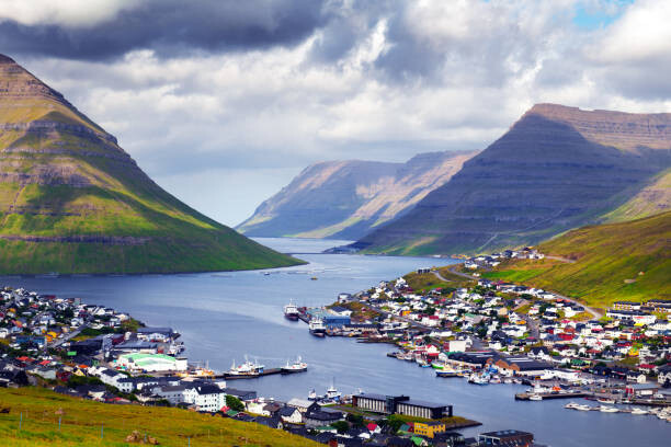
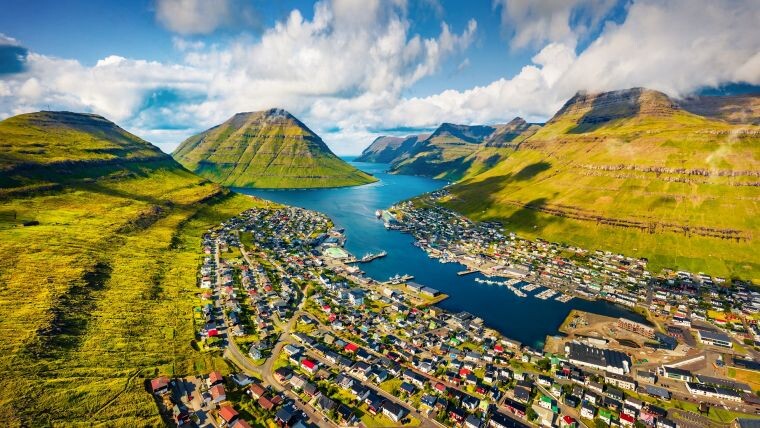
Upon exiting Leirvík, you will stay on Route 10. Another tunnel will be encountered here (Norðskálatunnilin), leading onwards in the direction of Klaksvík. Travel through the fishing town of Klaksvík, and you will then transition onto Route 24, which will quickly connect you to Route 70. Shortly after passing the 50-mile mark, a set of two tunnels will be reached. Continue on road number 70 in the direction of Hvannasund, proceeding north until you arrive at the town of Viðareiði (do not turn right into the tunnel).
When you arrive in Viðareiði a sharp left turn will guide you directly to the finish line, which is located at the small church (Viðareiði Kirkja).
Finish: https://commons.wikimedia.org/wiki/Vi%C3%B0arei%C3%B0i
The total route is about 60 miles with approximately roughly 11miles of unavoidable tunnels.
Turn by Turn (from mapmyrun):
Head north on Gamlivegur toward Sjóberið
0.00
mi
Head northwest on Hammershaimbsvegur toward Dalsbøur
0.14
mi
Head north on Hammershaimbsvegur
0.23
mi
At the roundabout, take the 1st exit onto Giljavegur/Route 11Continue to follow Route 11Destination will be on the right
0.23
mi
Head north on Vágavegur/Route 11 toward Route 93Destination will be on the right
3.54
mi
Head northeast on Vágartunnelen/Vágavegur/Route 11
5.19
mi
Head northeast on Vágartunnelen/Vágavegur/Route 11Continue to follow Vágavegur
7.71
mi
At the roundabout, take the 3rd exit onto Frammi í Dal/Route 11Destination will be on the left
7.81
mi
Head east on Frammi í Dal/Route 11Continue to follow Frammi í Dal
8.24
mi
At the roundabout, continue straight onto Inni í Firði/Route 10Continue to follow Route 10Destination will be on the right
11.29
mi
Head northeast on Route 10
12.95
mi
Head north on Route 10Destination will be on the right
14.67
mi
Head west on Route 10 toward BryggjanDestination will be on the right
17.77
mi
Head north on Route 10 toward ÁarvegurDestination will be on the right
18.08
mi
Head north on Sundalagsvegur/Sundalsvej toward vìð Áìr
18.24
mi
Head north on Sundalagsvegur/Sundalsvej toward vìð Áìr
18.57
mi
Head northwest on Sundalagsvegur/Sundalsvej toward vìð Áìr
19.80
mi
Head northwest on Sundalagsvegur/Sundalsvej toward Úti við NeystContinue to follow SundalagsvegurDestination will be on the right
20.34
mi
Head north on Sundalagsvegur toward Víkavegur
23.79
mi
Continue onto Tunnilsvegur við Norðskála
24.04
mi
Head northwest on Tunnilsvegur við Norðskála
24.99
mi
At the roundabout, take the 1st exit and stay on Tunnilsvegur við NorðskálaDestination will be on the right
25.25
mi
Head east on Tunnilsvegur við Norðskála
25.66
mi
Continue onto Norðskálatunnilin
26.26
mi
Head east on Norðskálatunnilin
26.87
mi
Continue onto Millum FjarðaDestination will be on the left
27.83
mi
Head east on Millum Fjarða
27.86
mi
Continue onto Skipanesvegur
29.50
mi
Head southeast on Skipanesvegur toward SkálafjarðarvegurDestination will be on the left
30.93
mi
Head southeast on Skipanesvegur
34.19
mi
Head southeast on Skipanesvegur
34.67
mi
Enter the roundabout
35.04
mi
Head southwest toward Skipanesvegur
35.08
mi
Exit the roundabout onto Route 10
35.12
mi
Head north on Route 10 toward Kinnarvegur
35.35
mi
Head northeast on Route 10 toward Kinnarvegur
36.46
mi
Head north on Route 10 toward við GjónnaDestination will be on the left
37.05
mi
Head north on Route 10 toward MortansstovubrekkaDestination will be on the right
37.57
mi
Head northwest on Route 10
37.94
mi
Head northwest on Route 10
38.21
mi
At the roundabout, take the 1st exit
38.31
mi
Continue onto Route 10Destination will be on the right
38.35
mi
Head northeast on Route 10 toward Líðarvegur
38.80
mi
Head southeast on Route 10 toward LíðarvegurDestination will be on the left
39.98
mi
Head south on Route 10 toward BiskupsmerkurGo through 2 roundabouts
40.28
mi
Head east on Route 10
40.68
mi
Head east on Route 10
41.07
mi
Head southeast on Eysturoyarvegur/Route 10
41.37
mi
Head east on Eysturoyarvegur/Route 10 toward MækjuvegurContinue to follow Route 10Destination will be on the right
43.96
mi
Head north on Mækjuvegur/Route 10
45.43
mi
At the roundabout, take the 2nd exit onto Mækjuvegur/Route 24Destination will be on the right
45.56
mi
Head north on Mækjuvegur/Route 24 toward Oyrarvegur
45.76
mi
Turn left onto Oyrarvegur
45.79
mi
Continue onto GeriagotaDestination will be on the left
45.94
mi
Head northwest on Geriagota
46.13
mi
At the roundabout, take the 1st exit onto Biskupsstodgota
46.15
mi
Head north on Biskupsstodgota
46.29
mi
Continue onto Nolsoyar Pals gota
46.30
mi
Continue onto StangavegurDestination will be on the right
46.49
mi
Head northeast on Stangavegur/Route 24 toward Route 71
47.57
mi
Continue onto Route 70Destination will be on the left
47.77
mi
Head east on Route 70 toward í UrðiniDestination will be on the right
49.23
mi
Head north on Route 70 toward Fossávegur
52.52
mi
Head east on Route 70 toward SundsvegurDestination will be on the right
52.80
mi
Head north on Route 70Destination will be on the left
53.06
mi
Head north on Route 70Destination will be on the right
53.76
mi
Head north on Route 70 toward BakkavegurDestination will be on the left
54.78
mi
Head east on Route 70 toward Bakkavegur
57.23
mi
Head northeast on Route 70 toward Bakkavegur
57.46
mi
Sharp left onto Bakkavegur
57.46
mi
Head northwest on Bakkavegur
57.55
mi
Head northwest on Bakkavegur toward Kirkjugøta
57.75
mi
Head west on Kirkjugøta
57.89
mi
Head on Kirkjugøta
57.95
mi
FKTs