This run is about more than pace. I’m doing it with my son to establish a new route—one that, to our knowledge, has never been attempted on foot in its entirety. Tórshavn to Eiði is a dramatic line across the Faroes, stitched together by road but shaped by wind, weather, and elevation.
It’s not just a test of endurance—it’s a shared effort to create something lasting. A first. A Fastest Known Time where none yet exists.
The Route:
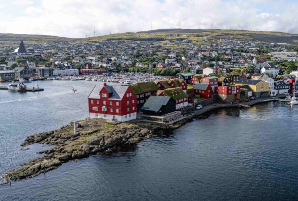
A paved, road route northbound traverse across Streymoy, connecting Tórshavn, the Faroese capital, with the northern village of Eiði. This point-to-point includes long, steady climbs, fast descents, and wide-open exposure to the North Atlantic elements. The route begins in the heart of Tórshavn, heads north along highway 10 and 11, and climbs toward the central highlands before descending into the coastal village of Eiði.
---
Turn by turn from MapMyRun:
Head northwest on Bryggjubakki toward Mylnugøta
0.00
mi
Turn left onto Tórsgøta
0.03
mi
Turn right to stay on Tórsgøta
0.04
mi
Turn left onto Niels Winthers gøta
0.16
mi
Continue onto Jóannesar Paturssonar gøta
0.20
mi
Turn right onto Dalavegur
0.29
mi
Head north on Marknagilsvegur/Vestari Ringvegur
0.74
mi
Direct/offroad route segment
0.76
mi
Head north toward Turnmasargøta
0.77
mi
Head southwest toward Turnmasargøta
0.81
mi
Slight right onto Skotarók
0.82
mi
Continue straight onto Írarók
0.85
mi
Head northeast on Hjaltarók
0.90
mi
Sharp left
0.90
mi
Head southwest
0.98
mi
Head southwest
1.04
mi
Head southwest
1.07
mi
Head northeast toward Oyggjarvegur/Route 50Partial restricted usage road
1.08
mi
Head northeast toward Oyggjarvegur/Route 50Restricted usage road
1.10
mi
Head west on Oyggjarvegur/Route 50
1.12
mi
Head west on Oyggjarvegur/Route 50 toward uden navn
1.15
mi
Head west on Oyggjarvegur/Route 50 toward uden navn
1.29
mi
Head northwest on Oyggjarvegur/Route 50 toward Undir HúsareyniDestination will be on the right
2.10
mi
Head northwest on Oyggjarvegur/Route 50
2.86
mi
Head northwest on Oyggjarvegur/Route 50Destination will be on the right
3.60
mi
Head northwest on Oyggjarvegur/Route 50 toward Norðradalsvegur
5.06
mi
Head west on Oyggjarvegur/Route 50 toward MjørkadalurDestination will be on the left
6.38
mi
Head northeast on Oyggjarvegur/Route 50Destination will be on the right
8.48
mi
Head northwest on Oyggjarvegur/Route 50Destination will be on the right
10.38
mi
Head northwest on Oyggjarvegur/Route 50 toward Frammi í Dal/Route 11
12.38
mi
Turn right onto Frammi í Dal/Route 11Destination will be on the left
12.71
mi
Head southeast on Frammi í Dal/Route 11
12.72
mi
Head southeast on Frammi í Dal/Route 11Continue to follow Frammi í Dal
13.73
mi
At the roundabout, take the 1st exit onto Inni í FirðiDestination will be on the right
13.99
mi
Head northeast on Inni í Firði/Route 10 toward Í LíðiniContinue to follow Route 10Destination will be on the left
14.92
mi
Head east on Route 10 toward Á Kjalnesi
16.63
mi
Turn leftDestination will be on the left
17.51
mi
Head southeast toward Route 10
17.51
mi
Turn left onto Route 10Destination will be on the right
17.52
mi
Head west on Route 10 toward BryggjanDestination will be on the left
20.23
mi
Head northwest on Sundalagsvegur/Sundalsvej toward Úti við Neyst
23.10
mi
Head northeast on Sundalagsvegur/Sundalsvej toward SundhøvdiContinue to follow Sundalagsvegur
25.41
mi
Head north on Sundalagsvegur toward VíkavegurDestination will be on the left
26.48
mi
Head east on Brúgvin um Streymin
26.60
mi
Head east on Brúgvin um Streymin
26.67
mi
Direct/offroad route segment
26.74
mi
Direct/offroad route segment
26.76
mi
Direct/offroad route segment
26.79
mi
Direct/offroad route segment
26.82
mi
Direct/offroad route segment
26.84
mi
Head northeast on Tunnilsvegur við Norðskála
26.88
mi
Head north on Tunnilsvegur við Norðskála
26.97
mi
Head north on Tunnilsvegur við Norðskála
27.08
mi
Head north on Tunnilsvegur við Norðskála
27.37
mi
Head northwest on Tunnilsvegur við Norðskála
27.76
mi
Head northwest on Tunnilsvegur við Norðskála
27.83
mi
Slight left to stay on Tunnilsvegur við Norðskála
27.92
mi
At the roundabout, take the 1st exit onto EiðisvegurDestination will be on the left
27.96
mi
Head northwest on Eiðisvegur toward Svínáavegur
28.03
mi
Head northwest on Eiðisvegur toward SvínáavegurDestination will be on the right
28.47
mi
Head northwest on Eiðisvegur
29.37
mi
Head north on Eiðisvegur toward Mylnuvegur
30.32
mi
Head north on Eiðisvegur toward MylnuvegurDestination will be on the right
31.49
mi
Head northwest on Eiðisvegur toward Í BarmiDestination will be on the left
32.09
mi
Head northeast on Eiðisvegur
33.28
mi
Head northwest on Eiðisvegur toward Yviri i Gjogv/Yviri í GjógvDestination will be on the right
33.95
mi