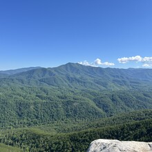
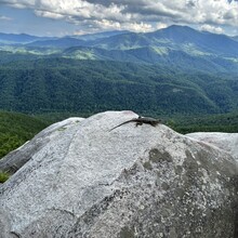
This route starts at a pull-off on Hartford Rd. It is a public (small) access point to the Pigeon River. From there, you will cross the road and take the only trail (Stone Mountain FS Trail #9) and begin the first and hardest climb to the Buzzards Roost. This is roughly 1.2 miles with a gain of 1400'. There view is a reward in itself from the Buzzards Roost (2 pics/both with Mt. Cammerer-GSMNP in the view and a large fence lizard). From there you will have a few steep rollers before you start the last climb to the summit. When there leaves are off the trees, as you climb on the ridge line, you have an amazing view of the rocky outcrops on Panther Mountain to the south. Before the summit, there is a 19th century cemetery (Halls Top) you will pass then immediately after, you will meet FS Road 207. Take a left and continue the climb for the summit (less than 1/2 mile). At the summit is a historical fire tower (4 pictures from inside the cab); this is the finish of the climb. On the descent, be mindful of your tracks around the cemetery, it is easy to follow an abandoned trail (as indicated in my tracks-easy to correct and get back to the main trail). This a great route for anyone looking to venture into the Cherokee National Forest while being able to enjoy the Great Smoky Mountains National Park only minutes away. Beautiful and isolated vistas are all over this route.
https://caltopo.com/m/U9AAGH7

